- Mount Royal, Quebec
-
Mount Royal
Ville de Mont-Royal— Town — Town of Mount Royal Motto: Regium Donum
(Latin for Royal gift)Location of Mount Royal on the Island of Montreal.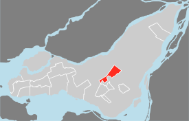
(Grey areas indicate demerged municipalities).'Coordinates: 45°30′58″N 73°38′35″W / 45.51611°N 73.64306°WCoordinates: 45°30′58″N 73°38′35″W / 45.51611°N 73.64306°W Country Canada Province Quebec Region Montréal Founded 1874 Incorporated 1912 Electoral Districts
Federal
Mount RoyalProvincial Mont-Royal Government[1][2][3] - Mayor Philippe Roy (interim) - Federal MP(s) Irwin Cotler (LIB) - Quebec MNA(s) Pierre Arcand (PLQ) Area[4] - Total 7.66 km2 (2.50 sq mi) Population (2006)[4] - Total 18,933 - Density 2,471.0/km2 (6,399.9/sq mi) - Change (2001-06)  1.3%
1.3%- Dwellings 7,377 Time zone Eastern (EST) (UTC-5) - Summer (DST) EDT (UTC-4) Postal code(s) H3P to H3R Area code(s) 514/438 Access Routes[5]
 A-15
A-15
 A-40
A-40
 A-520
A-520Website www.town.mount-royal.qc.ca Mount Royal (French: Mont-Royal) is a town located on the northwest side of Mount Royal, north of downtown Montreal, on the Island of Montreal in southwestern Quebec, Canada. The town is completely surrounded by Montreal. The population was 18,933 at the 2006 census (Statistics Canada, 2006).The town will celebrate its 100th anniversary in 2012.
Contents
Name
The town is commonly referred to as the Town of Mount Royal, or by the abbreviation TMR.
History
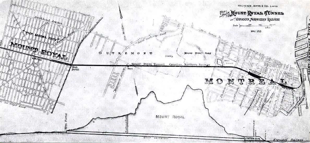
The town was founded in 1912. It was created at the initiative of the Canadian Northern Railway. The town was designed by Frederick Todd, a planner who was heavily influenced by the likes of Ebenezer Howard and incorporated many aspects of the Garden City Movement as well some elements of the earlier City Beautiful movement into his design.[6] The plan was to build a model city at the foot of the mountain. The company bought 4,800 acres (1,900 ha) of farmland, and then built a rail tunnel under Mount Royal connecting their land to downtown Montreal. The profits from the venture helped finance the development of Canadian Northern's transcontinental railroad, which eventually became a significant constituent of the Canadian National Railway system. The town was designed by Canadian Northern's chief engineer, Henry Wicksteed, based loosely on Washington, DC.
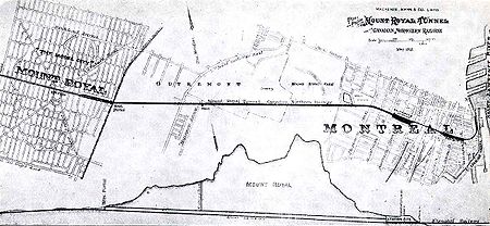 Plan of “Model City” and of the railroad tunnel
Mount Royal has always been an upper-income community, and until the 1960s its population was majority Anglophone. This began to change after the Quiet Revolution, as francophones gained access to better-paying careers. Mount Royal became popular and today the community is 46% francophone and home to many visible minorities.
The town was merged with the city of Montreal on January 1, 2002. On June 20, 2004 the residents of the town voted to demerge from Montreal following the calls for de-amalgamation. Mount Royal was re-established as a town on January 1, 2006.
Starting in June 2006, the town began to convert the designations on their bilingual street signs to French only signs, as mandated by law. This came after repeated requests from the Quebec French-language office, a provincial agency aimed at promoting French (the official language since 1977) in the province of Quebec (where 80% of the population is French-speaking), and limiting the use of English in public signs and official communications to situations where the Anglophone minority is sufficiently high. Some residents complained and the town agreed to reinstate the English lettering on the signs. The new English designations are now smaller than their official French equivalent, in compliance with the 1993 amendment to the Charter of the French Language. For unknown reasons, there are still street signs for several major boulevards for which the lettering has not been changed back to bilingual.
One notable feature of the town is the naming of some of its streets, and also its occasionally idiosyncratic numbering system. Some streets which pass through the town may thus bear two names (in whichever language). For example, Jean-Talon avenue, a large East-West thoroughfare crossing Montreal for kilometres, goes a few hundred meters through Mount Royal under the name of Dresden Avenue, only to recover its Montreal name on the other side of town. This situation has been recently ameliorated by putting the two names on the street signs. On these few hundred meters, Mount Royal uses a house civic numbering totally different from that of Montreal on either side. This sort of change in the numbering system also occurs on smaller streets shared by both Montreal and Mount Royal (for example, Trenton, Lockhart and Brookfield avenues, where the Mount Royal numbering system decreases from East to West, only to jump from 2 to 2400 on the few meters of the street that still belong to Montreal).
Geography
Two main thoroughfares, Laird Boulevard and Graham Boulevard, cut across the borough diagonally and meet at Connaught Park, a green space located in the centre. Mount Royal Train Station (Gare Mont-Royal) is located adjacent to this park, a commuter train station on the AMT Deux-Montagnes Line. Trains going through the Mount Royal Tunnel link the station to downtown Montreal in nine minutes.
Mount Royal is surrounded on three sides by a highway, a rail line and a fence.
The highway is Metropolitan Boulevard, a major constituent of Autoroute 40. It was built as an elevated highway throughout, except when it passes through Mount Royal (between Sainte Croix Avenue and L'Acadie Boulevard), since the town council requested that it be built on the ground, in order to separate the town from the industrial area to the north.
The rail line is the last portion of Canadian Pacific's Adirondack subdivision. It originally ran through the northern part of the district of Côte-des-Neiges. However when the town became part of the City of Montreal on Jan 1, 2002, the part of Côte-des-Neiges north of rail line was incorporated into the Mount Royal borough. When the town demerged on Jan 1, 2006 this part, known as Glenmont, reverted to Côte-des-Neiges.
A fence runs along the eastern border with Park Extension at L'Acadie Boulevard. The stated purpose of the fence is to prevent children and house pets from running into the busy thoroughfare but some have contended that it was built to keep residents of the working-class Park Extension neighbourhood out of the town.[7][8]
Government
Municipal
Town mayor Vera Danyluk stepped down in July 2010 due to illness - She passed away on Thursday, October 14, 2010. Philippe Roy was elected mayor by acclamation . Town council has six councillor seats: candidates run for a specific seat and are elected by the entire town electoral population (a ward system is not used). Only the town mayor sits on the agglomeration council of Montreal.
- Erin Kennedy (Seat No. 1)
- Fouad Sahyoun (Seat No. 2)
- John Miller (Seat No. 3)
- Minh-Diem Le Thi (Seat No. 4)
- Melpa Kamateros (Seat No. 5)
- Philippe Roy (Seat No. 6)
2005 Municipal Elections
The 2005 election, which took place on November 6, involved a three-way race for mayor between incumbent borough mayor Suzanne Caron, former mayor Vera Danyluk, and Brigitte Mack-Arsenault, president of a municipal watchdog association. The election also involved municipal political parties for the first time. Both Danyluk and Mack-Arsenault formed parties, and Caron, although officially running as an independent, affiliated herself with a group of independent candidates for town council.
Danyluk won the election.
Federal and Provincial
The entire borough is located within the federal riding of Mount Royal, and within the smaller provincial electoral district of Mount Royal.
Demographics
Note: Percentages may not add up to 100 percent due to rounding of data samples.
As of the census of 2001,[9] there were 18,682 people, 7,065 households, and 5,215 families residing in the city. The population density was 2,438.90/km². There were 7,267 housing units at an average density of 948.69/km². The racial makeup of the city was 84.51% White, 1.71% Black Canadian, 0.08% Aboriginal, 6.66% Asian Canadian, and 0.84% Latin American.
Languages
Knowledge of Official Languages (Statistics Canada: 2006,[10] 2001[11]) Language(s) 2006 2001 Percentage (%) Percentage (%) Both English and French 77.6% 76.9% English only 10.1% 11.6% French only 11.1% 10.1% Neither English nor French 1.2% 1.4% The 2006 census found that, counting single responses only, French was spoken as a mother tongue by 43.9% of the population, which was a decrease from 46.4% in 2001. English was spoken as a mother tongue by a total of 21.8% of the population in 2006, which was a decrease from 26.2% in 2001. Counting single responses only, the next most common mother tongues were Arabic (7.3%), Greek (3.1%), Italian (3.0%), Armenian and Chinese (2.5% each), and Vietnamese (2.4%).[12]
Mother tongue Population Percentage French 8,185 43.86% English 4,060 21.76% English and French 225 1.21% English and a non-official language 210 1.13% French and a non-official language 160 0.86% English, French and a non-official language 55 0.29% Arabic 1,355 7.26% Greek 570 3.05% Italian 555 2.97% Armenian 465 2.49% Chinese languages 460 2.47% Vietnamese 445 2.38% Romanian 280 1.50% Spanish 155 0.83% Persian 155 0.83% Russian 145 0.78% Mother tongue Population Percentage German 125 0.67% Korean 95 0.51% Polish 85 0.46% Hungarian 80 0.43% Tagalog 75 0.40% Creole 60 0.32% Tamil 60 0.32% Gujarati 45 0.24% Ukrainian 45 0.24% Portuguese 40 0.21% Hebrew 35 0.19% Yiddish 35 0.19% Bulgarian 30 0.16% Czech 25 0.13% Kurdish 25 0.13% Slovak 25 0.13% Home language (2006) Language Population Percentage (%) French 9,145 49.02% English 6,375 34.17% Both English and French 395 2.12% Other languages 2,745 14.71% Age
In the city the population was spread out with 18.7% under the age of 15, 11.6% from 15 to 24, 24.8% from 25 to 44, 26.0% from 45 to 64, and 19.0% who were 65 years of age or older. The median age was 41 years. For every 100 females there were 89.2 males. For every 100 females age 15 and over, there were 85.9 males.
Households
There were 7,065 households out of which 33.7% had children living with them, 57.6% were married couples living together, 7.2% had a female lone-parent as a householder, and 25.8% of all households were made up of individuals. The average married-couple family size was 3.2.
Religion
As of 2001, Christians made up 71.9% of the population, or 53.2% Catholic, 6.0% Protestant, 10.9% Orthodox, and 1.8% other Christian. Other religions in the city include 12% Jewish, 5.5% Muslim, 2.3% Buddhist, and 0.6% other religions. 7.6% of the population claimed to have no religious affiliation.[13]
Income
As of 2006, the median income for a household in the city was $86,743 CAD, and the median income for a family was $112,449 CAD. Males had an average income of $86,428 CAD versus $41,883 CAD for females. About 4.5% of the labour force was unemployed. The largest occupation categories were 20.7% employed in management occupations, 20.3% business, finance, and administration occupations, and 17.9% in sales and service occupations.
References
- ^ Ministère des Affaires Municipales et Régions: Mont Royal
- ^ Parliament of Canada Federal Riding History: MOUNT ROYAL (Quebec)
- ^ Chief Electoral Officer of Québec - 40th General Election Riding Results: MONT-ROYAL
- ^ a b 2006 Statistics Canada Community Profile: Mount Royal, Quebec
- ^ Official Transport Quebec Road Map
- ^ Sewell, John. "The Shape of the City: Toronto Struggles with Modern Planning" page 52 University of Toronto Press Inc. 1993
- ^ Kristian Gravenor, "Segregation fence to live on." Montreal Mirror, November 8, 2001.
- ^ Photographer gets hassled by municipal security.
- ^ Statistics Canada (2007-01-02). "2001 Community Profiles: Community Highlights for Mont-Royal". Statistics Canada. http://www12.statcan.ca/english/profil01/CP01/Details/Page.cfm?Lang=E&Geo1=CSD&Code1=2466070&Geo2=PR&Code2=24&Data=Count&SearchText=royal&SearchType=Contains&SearchPR=24&B1=All&Custom=. Retrieved 2007-12-01.
- ^ Statistics Canada. "2006 Community Profiles: Community Highlights for Mont-Royal". Statistics Canada. http://www12.statcan.ca/english/census06/data/profiles/community/Details/Page.cfm?Lang=E&Geo1=CSD&Code1=2466072&Geo2=PR&Code2=24&Data=Count&SearchText=Mont-Royal&SearchType=Begins&SearchPR=01&B1=All&GeoLevel=&GeoCode=2466072. Retrieved 2007-12-04.
- ^ Statistics Canada. "Language Composition of Canada: Knowledge of Official Languages". Statistics Canada. http://www12.statcan.ca/english/census01/products/highlight/LanguageComposition/Page.cfm?Lang=E&Geo=CSD&View=1b&Code=0&Table=2a&StartRec=377&Sort=2&B1=Distribution&B2=Both. Retrieved 2007-12-01.
- ^ "Mont-Royal, V". Detailed Mother Tongue (103), Knowledge of Official Languages (5), Age Groups (17A) and Sex (3) for the Population of Canada, Provinces, Territories, Census Divisions and Census Subdivisions, 2006 Census - 20% Sample Data. Statistics Canada. 2007-11-20. http://www12.statcan.ca/english/census06/data/topics/RetrieveProductTable.cfm?ALEVEL=3&APATH=3&CATNO=&DETAIL=0&DIM=&DS=99&FL=0&FREE=0&GAL=0&GC=99&GK=NA&GRP=1&IPS=&METH=0&ORDER=1&PID=89202&PTYPE=88971&RL=0&S=1&ShowAll=No&StartRow=1&SUB=701&Temporal=2006&Theme=70&VID=0&VNAMEE=&VNAMEF=&GID=773023. Retrieved 2008-02-06.
- ^ "2001 Community Profiles - Population". Canada 2006 census. Statistics Canada. 2001. http://www12.statcan.ca/english/Profil01/CP01/Details/Page.cfm?Lang=E&Geo1=CSD&Code1=2466070&Geo2=PR&Code2=24&Data=Count&SearchText=mont-royal&SearchType=Begins&SearchPR=01&B1=Population&Custom=. Retrieved 26 July 2010.
See also

 Ahuntsic-Cartierville (Montreal) Villeray–Saint-Michel–Parc-Extension (Montreal) Saint-Laurent (Montreal)
 Outremont (Montreal)
 Mount Royal
 Cote-des-Neiges--Notre-Dame-de-Grace (Montreal)Categories:
- Cities and towns in Quebec
- Former Montreal boroughs
- Island of Montreal municipalities
- Quebec communities with significant anglophone populations
- Populated places established in 1912
- Planned cities in Canada

Wikimedia Foundation. 2010.