- Crémazie (Montreal Metro)
-
 Montreal Metro Station

Borough Ahuntsic-Cartierville and Villeray–Saint-Michel–Parc-Extension City Montreal Opened 14 October 1966 Line  Orange Line
Architect Adalbert Niklewicz Artist Georges Lauda, Paul Pannier, & Gérald Cordeau Platform Depth 16.8 metres Rank 27th deepest Traffic 3,744,890 entrances in 2006 Rank 21st busiest Interstation
Distance825.60 metres to Jarry
1279.60 metres to SauvéAddress of
Entrances505, boul. Crémazie
490, boul. CrémazieNearby Main
Intersectionsboul. Crémazie (Autoroute 40) / rue Berri
boul. Crémazie / rue St.-Dénis [1]
Crémazie is a station on the Orange Line of the Montreal Metro rapid transit system, operated by the Société de transport de Montréal (STM). It is located on the border between the boroughs of Ahuntsic-Cartierville and Villeray–Saint-Michel–Parc-Extension in Montreal, Quebec, Canada [2]. The station opened October 14, 1966, as part of the original network of the metro.Contents
Overview
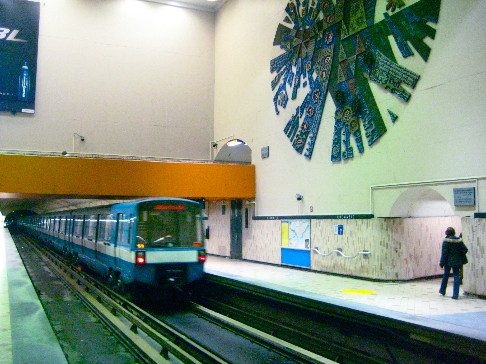
The metro station, designed by Adalbert Niklewicz, is a normal side platform station, built in tunnel. A large volume serves as the transept, with three of the four platform stairways in enclosed tunnels. The mezzanine serves two entrances, one on each side of the Autoroute Métropolitaine, and both integrated into buildings; the northern access has doors both in front of and behind the building.
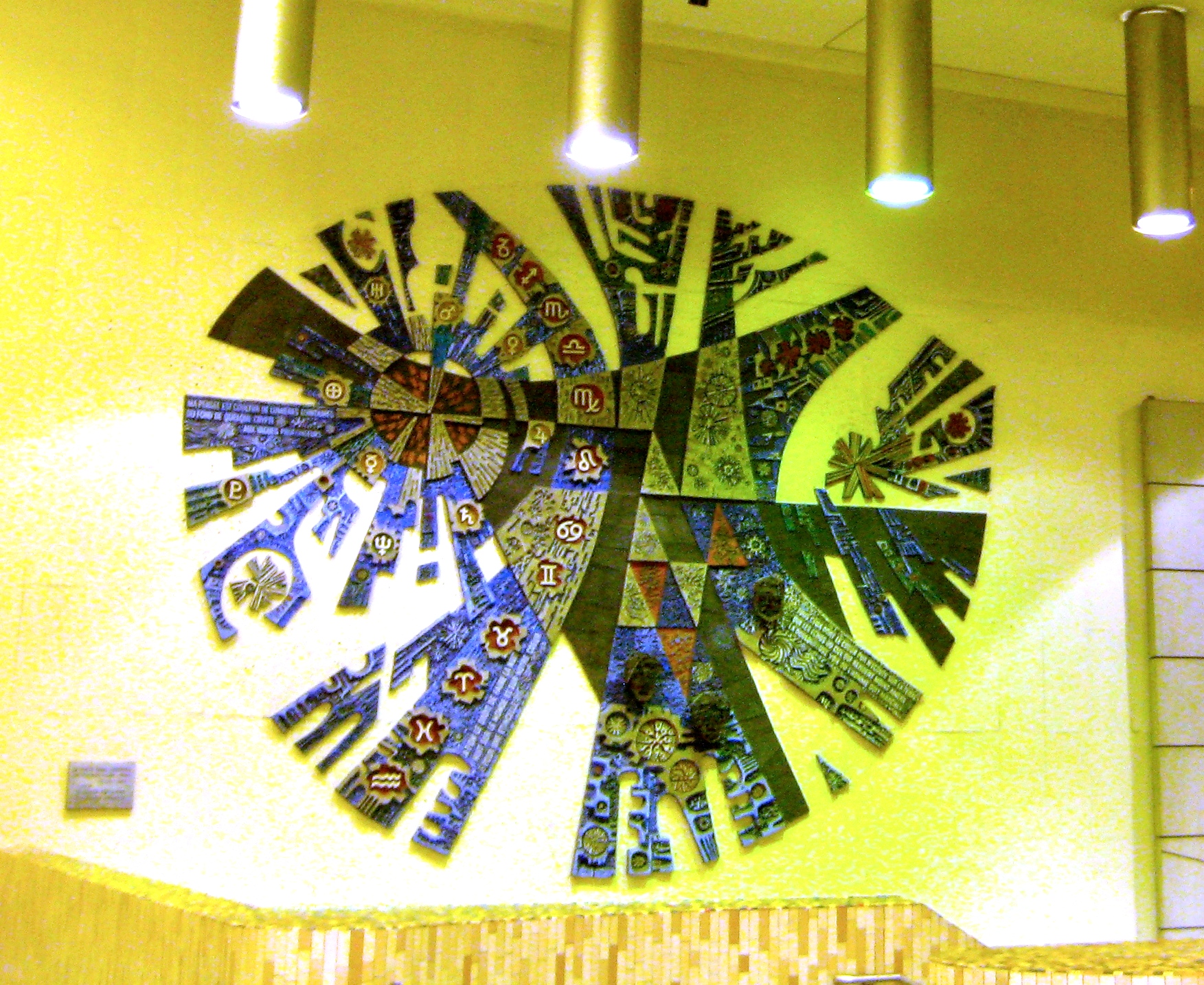
A large ceramic mural by Georges Lauda, Paul Pannier, and Gérald Cordeau, Le poète dans l'univers ("the poet in the universe"), is located on the wall of the large volume, over the Montmorency platform. It commemorates three famous Quebec poets, Octave Crémazie, Émile Nelligan, and Hector de Saint-Denys Garneau, represented by wrought iron masks on the mural.
Origin of the name
This station is named for boul. Crémazie, in turn commemorating Octave Crémazie (1827–1879), one of Quebec's most important poets and the author of "Le Drapeau de Carillon." The street was so named in 1914.
Connecting bus routes
Main article: List of Montreal Bus RoutesRoute Service Times Map Schedule Société de transport de Montréal  19 Chabanel/Marché Central
Evenings Monday-Friday Map Schedule 31 Saint-DenisAll-day Map Schedule 52 LiègeRush Hour Monday-Friday Map Schedule 53 Boulevard Saint-LaurentAll-day Map Schedule 54 Charland/ChabanelAll-day Monday-Friday Map Schedule 56 Saint-HubertSchool Year Service Map Schedule 100 CrémazieAll-day Map Schedule 135 De l'EsplanadeRush Hour Monday-Friday Map Schedule 146 Christophe-Colomb/MeilleurAll-day Map Schedule 192 RobertAll-day Map Schedule 460 MétropolitaineAll-day Monday-Friday Map Schedule  361 Saint-Denis
Overnight Map Schedule Nearby points of interest
- Complexe FTQ
- Collège Ahuntsic
- Collège André-Grasset
- Complexe sportif Claude-Robillard
References
External links
- Crémazie Station — official site
- Montreal by Metro, metrodemontreal.com — photos, information, and trivia
- 2008 STM System Map
- Metro Map
Line 1 Green Angrignon • Monk • Jolicoeur • Verdun • De L'Église • LaSalle • Charlevoix • Lionel-Groulx • Atwater • Guy-Concordia • Peel • McGill • Place-des-Arts • Saint-Laurent • Berri-UQAM • Beaudry • Papineau • Frontenac • Préfontaine • Joliette • Pie-IX • Viau • Assomption • Cadillac • Langelier • Radisson • Honoré-BeaugrandLine 2 Orange Côte-Vertu • Du Collège • De La Savane • Namur • Plamondon • Côte-Sainte-Catherine • Snowdon • Villa-Maria • Vendôme • Place-Saint-Henri • Lionel-Groulx • Georges-Vanier • Lucien-L'Allier • Bonaventure • Square-Victoria • Place-d'Armes • Champ-de-Mars • Berri-UQAM • Sherbrooke • Mont-Royal • Laurier • Rosemont • Beaubien • Jean-Talon • Jarry • Crémazie • Sauvé • Henri-Bourassa • Cartier • De La Concorde • MontmorencyLine 4 Yellow Line 5 Blue Snowdon • Côte-des-Neiges • Université-de-Montréal • Édouard-Montpetit • Outremont • Acadie • Parc • De Castelnau • Jean-Talon • Fabre • D'Iberville • Saint-MichelCoordinates: 45°32′46.15″N 73°38′18.38″W / 45.5461528°N 73.6384389°W
Categories:- Montreal Metro Orange Line
Wikimedia Foundation. 2010.