- Namur (Montreal Metro)
-
 Montreal Metro Station
Borough Côte-des-Neiges–Notre-Dame-de-Grâce City Montréal Opened January 9, 1984 Line  Orange Line
Architect Labelle, Marchand et Geoffroy Artist Pierre Granche Platform Depth 24.1 metres Rank 7th deepest Traffic 1,931,107 entrances in 2006 Rank 45th busiest Interstation
Distance768.70 metres to De La Savane
988.47 metres to Plamondon
Address of
Entrances7405, boul. Décarie Nearby Main
Intersectionsboul. Décarie (Autoroute 15) / rue Jean-Talon [1]
Namur is a station on the Orange Line of the Montreal Metro rapid transit system, operated by the Société de transport de Montréal (STM). It is located in the Côte-des-Neiges area of the borough of Côte-des-Neiges–Notre-Dame-de-Grâce in Montreal, Quebec, Canada [2]. This station has a total of 428 parking spaces in two nearby parking lots [3].Contents
Overview
The station is a normal side platform station with an entrance at the north end. It was planned in such a way as to allow an additional entrance to be built on the other side of the Décarie Autoroute, but this has not yet happened. A redevelopment plan for the area is under discussion.
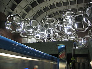
The station was designed by the firm of Labelle, Marchand et Geoffroy. The station's mezzanine contains a giant suspended illuminated aluminum sculpture, entitled Système, by noted Quebec artist Pierre Granche.
Origin of the name
This station is named for rue Namur, the former name for a portion of rue Jean-Talon; the road had been renamed by the time the station was opened, so a nearby road (rue Arnoldi) was renamed Namur in 1980 to allow the station to keep its name. Namur is a city and province in Belgium.
Connecting bus routes
Main article: Société de transport de MontréalMain article: List of Montreal Bus RoutesRoute Service Times Map Schedule Société de transport de Montréal  17 Décarie
All-day Map Schedule 92 Jean-Talon OuestAll-day Map Schedule 115 ParéRush Hour Monday-Friday Map Schedule  368 Mont Royal
Overnight Map Schedule 369 Côte-des-NeigesOvernight Map Schedule 371 DécarieOvernight Map Schedule 372 Jean-TalonOvernight Map Schedule 376 Pierrefonds/DowntownOvernight Map Schedule 382 Pierrefonds/Saint-CharlesOvernight Map Schedule Nearby points of interest
- Décarie Autoroute
- Hippodrome de Montréal
- Dollar Cinema
- Gibeau Orange Julep
- Decarie Square Mall
- Wal-Mart
- Montreal SPCA
See also
References
External links
- Namur Station - official web page
- Namur metro station geo location
- Montreal by Metro, metrodemontreal.com
- Parking (Métroparc)
- 2008 STM System Map
- Metro Map
Line 1 Green Angrignon • Monk • Jolicoeur • Verdun • De L'Église • LaSalle • Charlevoix • Lionel-Groulx • Atwater • Guy-Concordia • Peel • McGill • Place-des-Arts • Saint-Laurent • Berri-UQAM • Beaudry • Papineau • Frontenac • Préfontaine • Joliette • Pie-IX • Viau • Assomption • Cadillac • Langelier • Radisson • Honoré-BeaugrandLine 2 Orange Côte-Vertu • Du Collège • De La Savane • Namur • Plamondon • Côte-Sainte-Catherine • Snowdon • Villa-Maria • Vendôme • Place-Saint-Henri • Lionel-Groulx • Georges-Vanier • Lucien-L'Allier • Bonaventure • Square-Victoria • Place-d'Armes • Champ-de-Mars • Berri-UQAM • Sherbrooke • Mont-Royal • Laurier • Rosemont • Beaubien • Jean-Talon • Jarry • Crémazie • Sauvé • Henri-Bourassa • Cartier • De La Concorde • MontmorencyLine 4 Yellow Line 5 Blue Snowdon • Côte-des-Neiges • Université-de-Montréal • Édouard-Montpetit • Outremont • Acadie • Parc • De Castelnau • Jean-Talon • Fabre • D'Iberville • Saint-MichelCoordinates: 45°29′41.05″N 73°39′9.98″W / 45.4947361°N 73.6527722°W
Categories:- Montreal Metro Orange Line
- Railway stations opened in 1984

Wikimedia Foundation. 2010.