- Charlevoix (Montreal Metro)
-
 Montreal Metro Station
Borough Le Sud-Ouest City Montreal Opened 3 September 1978 Line  Green Line
Architect Ayotte et Bergeron Artist Pierre Osterrath & Mario Merola Platform Depth 24.4 metres (Angrignon platform)
29.6 metres (Honoré-Beaugrand platform)Rank Deepest Traffic 1,660,156 entrances in 2006 Rank 49th busiest Interstation
Distance707.25 metres to LaSalle
1077.31 metres to Lionel-Groulx
Address of
Entrances2600, Centre Street, corner Charlevoix Street Nearby Main
IntersectionsCentre Street / Charlevoix Street[1]
Charlevoix is a station on the Green Line of the Montreal Metro rapid transit system operated by the Société de transport de Montréal (STM). It is located in the district of Pointe-Saint-Charles in the borough of Le Sud-Ouest in Montreal, Quebec, Canada[2].The station opened on September 3, 1978, as part of the extension of the Green Line westward to Angrignon.Contents
Architecture and art
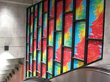 Stained-glass windows at the station.
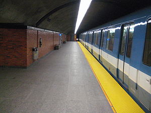
Designed by Ayotte et Bergeron, it was built as a stacked platform station, in order to reduce the width of the station owing to the weak Utica shale in which it was built. The lower (Honoré-Beaugrand) platform is 29.6m below the surface, making this the deepest station in the network, as well as the lowest in altitude (the lower platform is below sea level).
The station has one ticket hall and one access. The long stairways to the platforms, built around a light shaft, are brightened by two stained-glass windows by Mario Merola and Pierre Osterrath.
Origin of the name
This station is named for rue Charlevoix. François-Xavier de Charlevoix (1682–1687) was a French Jesuit historian and explorer of New France.
Connecting bus routes
Main article: Société de transport de MontréalMain article: List of Montreal Bus RoutesRoute Service Times Map Schedule Société de transport de Montréal  57 Pointe-Saint-Charles
All-day Map Schedule 101 Saint-PatrickRush Hour Monday-Friday Map Schedule 107 VerdunAll-day Map Schedule  350 Verdun/LaSalle
Overnight Map Schedule Nearby points of interest
- Centre Saint-Charles
- St. Columba House
- Clinique communautaire de Pointe-Saint-Charles
- Carrefour d'éducation publique
- Parc du Canal-de-Lachine
References
External links
- Charlevoix Station - official site
- Montreal by Metro, metrodemontreal.com - photos, information, and trivia
- 2008 STM System Map
- 2008 Downtown System Map
- Metro Map
Line 1 Green Angrignon • Monk • Jolicoeur • Verdun • De L'Église • LaSalle • Charlevoix • Lionel-Groulx • Atwater • Guy-Concordia • Peel • McGill • Place-des-Arts • Saint-Laurent • Berri-UQAM • Beaudry • Papineau • Frontenac • Préfontaine • Joliette • Pie-IX • Viau • Assomption • Cadillac • Langelier • Radisson • Honoré-BeaugrandLine 2 Orange Côte-Vertu • Du Collège • De La Savane • Namur • Plamondon • Côte-Sainte-Catherine • Snowdon • Villa-Maria • Vendôme • Place-Saint-Henri • Lionel-Groulx • Georges-Vanier • Lucien-L'Allier • Bonaventure • Square-Victoria • Place-d'Armes • Champ-de-Mars • Berri-UQAM • Sherbrooke • Mont-Royal • Laurier • Rosemont • Beaubien • Jean-Talon • Jarry • Crémazie • Sauvé • Henri-Bourassa • Cartier • De La Concorde • MontmorencyLine 4 Yellow Line 5 Blue Snowdon • Côte-des-Neiges • Université-de-Montréal • Édouard-Montpetit • Outremont • Acadie • Parc • De Castelnau • Jean-Talon • Fabre • D'Iberville • Saint-MichelCoordinates: 45°28′42.99″N 73°34′10.26″W / 45.4786083°N 73.5695167°W
Categories:- Montreal Metro Green Line


Wikimedia Foundation. 2010.