- Montmorency (Montreal Metro)
-
 Montreal Metro Station

Borough Laval-des-Rapides City Laval Opened 26 April 2007 Line  Orange Line
Architect Guillermo Farregut Artist Hélène Rochette Platform Depth 20 metres Rank 18th deepest Traffic Rank Interstation
Distance847.60 metres to De La Concorde Address of
EntrancesMain entrance: 1800, rue Jacques-Tétreault
Bus terminal: 555, rue Lucien-PaiementNearby Main
Intersectionsrue Jacques-Tétreault / rue Lucien-Paiement
rue Lucien-Paiement / rue Claude-Gagné
Autoroute 15 / Boulevard de la Concorde ouest
Boulevard de la Concorde ouest / Boulevard le Corbusier
Boulevard de la Concorde ouest / Boulevard de l'Avenir
Boulevard du Souvenir / Boulevard le Corbusier.
Boulevard du Souvenir / Boulevard de l'Avenir [1][2]
Montmorency is a station on the Orange Line of the Montreal Metro rapid transit system, operated by the Société de transport de Montréal (STM). It is located in the Laval-des-Rapides area of Laval, Quebec, Canada [3]. The station is part of an extension to the line to Laval and opened on April 28, 2007, becoming the northern terminus of the Orange Line. With the addition of the new metro stations, the Montreal Metro system now generates an extra 60,000 daily passengers. As of 2010, 1,050,000 daily passengers use the Montreal metro.[4]Contents
Overview
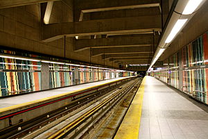
It is a normal side platform station. This station has the highest ceilings of any station in the network. The wall panels are decorated with tiling in diagonal stripes of retro shades of cyan, navy, straw yellow and brick red.
The station is equipped with the MétroVision information screens which displays news, commercials, and the time till the next train.
Station Features
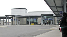
The station boasts a large bus terminal with 10 platforms and an indoor waiting area. The building features an AMT ticket counter as well as a convenience store and a coffee shop. In addition, the station has parking for 1342 cars — 644 free outdoor park and ride spaces and 698 paying spaces (54 outdoor, 644 indoor) [5]. The indoor spaces cost $6 a day or $80 per month (if a user purchases a monthly parking pass).
Origin of name
The station is located across the street from Cégep Montmorency. The CEGEP got its name from François de Montmorency-Laval (1623–1703), the first bishop of Quebec and New France from 1674 to 1688.
Connecting bus routes
Société de transport de Laval (STL)
STL Regular routes No. Route Description Route Map Schedule 26 Gare Sainte-Dorothée - Metro Montmorency Map Schedule 33 Métro Montmorency - Métro Cartier Map Schedule 39 Auteuil - Terminus Le Carrefour Map Schedule 40 Chomedey - Metro Montmorency Map Schedule 42 Saint-François - Terminus Le Carrefour,
via Metro De La Concorde, see note no. 1Map Schedule 45 Gare Vimont - Metro Montmorency Map Schedule 46 Laval-Ouest - Metro Montmorency Map Schedule 50 Saint-Vincent-de-Paul - Terminus Le Carrefour Map Schedule 56 Sainte-Dorothée - Metro Montmorency Map Schedule 61 Sainte-Rose - Metro Montmorency Map Schedule 63 Gare Ste-Rose - Metro Cartier, see note no. 2 Map Schedule 65 Gare Ste-Rose - Metro Montmorency Map Schedule 70 Métro Montmorency - Métro Cartier Map Schedule 76 Gare Sainte-Dorothée - Metro Montmorency Map Schedule 903 Gare Sainte-Dorothée - Metro Montmorency Map Schedule STL Night route No. Route Description Route Map Schedule 2 Night route between Henri-Bourassa and Metro Montmorency via Metro Cartier & Metro De La Concorde, see note no. 3 Map Schedule Notes
- STL route No. 42 no longer enters the terminus proper but stops on boulevard de l'Avenir and rue Jacques-Tétreault outside of the terminus[6][7].
- STL route No. 63 no longer enters the terminus proper but stops on boulevard de l'Avenir and rue Jacques-Tétreault outside of the terminus[8][9].
- STL route No. 2 offers a late night and early morning connection between stations Montmorency and Henri-Bourassa, Monday to Saturday only.
Inter municipal buses
No. Transit Agency Main Destination Route Map Schedule 8 CIT Laurentides Express to Terminus Saint-Eustache in Saint-Eustache West Zone Schedule 9 CIT Laurentides Terminus Saint-Jérôme in Saint-Jérôme Center Zone Schedule 19A MRC Les Moulins
(CRT Lanaudière)Terminus Terrebonne in Terrebonne Map Schedule Nearby points of interest
See also
References
- ^ Neighbourhood Map
- ^ STL Neighbourhood Map[dead link]
- ^ Montmorency Metro Station
- ^ Radio Canada
- ^ Parking
- ^ STL 42
- ^ Map 42
- ^ STL 63
- ^ Map 63
External links
- AMT Montmorency Terminus
- AMT Page on inter municipal bus services
- Montmorency Station web page (French)
- Agence métropolitaine de transport - Métro à Laval (French)
- Montreal by Metro, metrodemontreal.com
- STL website (English)
- 2005 Service map (before opening of metro extension) (French)
- 2008 Current STL System Map (French)
- 2008 STM System Map
- Metro Map
- Pictures of the new Laval Metro - (English)
- STL Schedules
- Interactive STL map
- CIT Laurentides
- Interactive map of Laval
- Shows both the borders and names of the 14 former municipalities (purple) and the borders only of the
current 6 sectors (maroon), tick off both boxes
beside "Limite administrative".
- Shows both the borders and names of the 14 former municipalities (purple) and the borders only of the
Line 1 Green Angrignon • Monk • Jolicoeur • Verdun • De L'Église • LaSalle • Charlevoix • Lionel-Groulx • Atwater • Guy-Concordia • Peel • McGill • Place-des-Arts • Saint-Laurent • Berri-UQAM • Beaudry • Papineau • Frontenac • Préfontaine • Joliette • Pie-IX • Viau • Assomption • Cadillac • Langelier • Radisson • Honoré-BeaugrandLine 2 Orange Côte-Vertu • Du Collège • De La Savane • Namur • Plamondon • Côte-Sainte-Catherine • Snowdon • Villa-Maria • Vendôme • Place-Saint-Henri • Lionel-Groulx • Georges-Vanier • Lucien-L'Allier • Bonaventure • Square-Victoria • Place-d'Armes • Champ-de-Mars • Berri-UQAM • Sherbrooke • Mont-Royal • Laurier • Rosemont • Beaubien • Jean-Talon • Jarry • Crémazie • Sauvé • Henri-Bourassa • Cartier • De La Concorde • MontmorencyLine 4 Yellow Line 5 Blue Snowdon • Côte-des-Neiges • Université-de-Montréal • Édouard-Montpetit • Outremont • Acadie • Parc • De Castelnau • Jean-Talon • Fabre • D'Iberville • Saint-MichelCoordinates: 45°33′28.78″N 73°43′16.71″W / 45.5579944°N 73.7213083°W
Categories:- Montreal Metro Orange Line
- AMT bus stations
- Railway stations opened in 2007
- Transportation in Laval, Quebec
Wikimedia Foundation. 2010.


