- Côte-des-Neiges (Montreal Metro)
-
 Montreal Metro Station

Borough Côte-des-Neiges–Notre-Dame-de-Grâce City Montreal Opened 4 January 1988 Line  Blue Line
Architect Tétreault, Parent, Languedoc Artist Bernard Chaudron, Claude Bettinger Platform Depth 17.6 metres Rank 24th deepest Traffic 3,524,127 entrances in 2006 Rank 26th busiest Interstation
Distance959.60 metres to Snowdon
764.60 metres to Université-de-Montréal
Address of
Entrances5316, chemin de la Côte-des-Neiges
5351, chemin de la Côte-des-NeigesNearby Main
IntersectionsCôte-des-Neiges Road / Lacombe Avenue [1] Côte-des-Neiges is a station on the Blue Line of the Montreal Metro rapid transit system, operated by the Société de transport de Montréal (STM). It is located in the Côte-des-Neiges area of the borough of Côte-des-Neiges—Notre-Dame-de-Grâce in Montreal, Quebec, Canada [2].
Contents
Overview
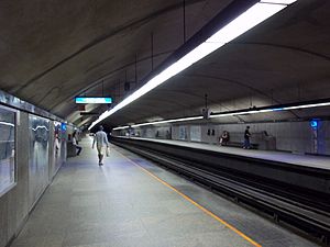
It is a normal side platform station built in tunnel. A ticket hall, also in tunnel, diverges to two entrances, one on each side of Ch. de la Côte-des-Neiges. The western entrance is housed in an imposing building containing a stained glass window by Claude Bettinger, while the eastern one is integrated into another building and includes a suite of sculptures by Bernard Chaudron. A second stained-glass mural by Bettinger is found in the transept leading to the platforms.
Origin of name
Côte-des-Neiges metro station takes its name from the road on which it lies: Côte-des-Neiges Road.
Côte-des-Neiges Road takes its name from the settlement originally on this location, the Village of Côte-des-Neiges, which was created in 1862, and annexed by Montreal in two parts in 1908 and 1910.
The name for the area, Côte de Notre-Dame des Neiges (Our Lady of the Snows Hill), dates from the early 18th century. The name lives on in the church and the school in the centre of the former village.
Connecting bus routes
Main article: List of Montreal Bus RoutesRoute Service Times Map Schedule Société de transport de Montréal  119 Rockland
All-day Map Schedule  165 Côte-des-Neiges
All-day Map Schedule  535 Reserve Lane Parc/Côte-des-Neiges
Rush Hour Monday-Friday Map Schedule  369 Côte-des-Neiges
Overnight Map Schedule Nearby points of interest
- St. Mary's Hospital
- Maison de la culture Côte-des-Neiges
- Centre communautaire de la Côte-des-Neiges
- École Notre-Dame-des-Neiges
- Église Notre-Dame-des-Neiges
- Collège Notre-Dame du Sacré-Coeur
- Saint Joseph's Oratory
- Notre Dame des Neiges Cemetery
- Université de Montréal (Jean-Brillant building)
- École des hautes études commerciales
(HEC) (Décelles building)
- École des hautes études commerciales
- Collège Jean-de-Brébeuf
- Hôpital Sainte-Justine
- Jewish General Hospital
References
External links
- Côte-des-Neiges station information on STM website
- Montreal by Metro, metrodemontreal.com
- 2008 STM System Map
- Metro Map
Line 1 Green Angrignon • Monk • Jolicoeur • Verdun • De L'Église • LaSalle • Charlevoix • Lionel-Groulx • Atwater • Guy-Concordia • Peel • McGill • Place-des-Arts • Saint-Laurent • Berri-UQAM • Beaudry • Papineau • Frontenac • Préfontaine • Joliette • Pie-IX • Viau • Assomption • Cadillac • Langelier • Radisson • Honoré-BeaugrandLine 2 Orange Côte-Vertu • Du Collège • De La Savane • Namur • Plamondon • Côte-Sainte-Catherine • Snowdon • Villa-Maria • Vendôme • Place-Saint-Henri • Lionel-Groulx • Georges-Vanier • Lucien-L'Allier • Bonaventure • Square-Victoria • Place-d'Armes • Champ-de-Mars • Berri-UQAM • Sherbrooke • Mont-Royal • Laurier • Rosemont • Beaubien • Jean-Talon • Jarry • Crémazie • Sauvé • Henri-Bourassa • Cartier • De La Concorde • MontmorencyLine 4 Yellow Line 5 Blue Snowdon • Côte-des-Neiges • Université-de-Montréal • Édouard-Montpetit • Outremont • Acadie • Parc • De Castelnau • Jean-Talon • Fabre • D'Iberville • Saint-MichelCoordinates: 45°29′47.22″N 73°37′24.31″W / 45.49645°N 73.6234194°W
Categories:- Montreal Metro Blue Line
Wikimedia Foundation. 2010.
