- De La Concorde (Montreal Metro)
-
 Montreal Metro Station
Borough Laval-des-Rapides City Laval Opened 26 April 2007 Line  Orange Line
Architect André Marcotte Artist Yves Gendreau Platform Depth 15 Metres Rank 25th Traffic Rank Interstation
Distance2073.60 metres to Cartier
847.60 metres to Montmorency
Address of
Entrances1200, boul. de la Concorde Ouest Nearby Main
IntersectionsBoulevard De la Concorde Ouest / avenue Ampère (east of station)
Boulevard De la Concorde Ouest / Boulevard Laval (west of station) [1] [2]De la Concorde is a station on the Orange Line of the Montreal Metro rapid transit system, operated by the Société de transport de Montréal (STM). It is located in the Laval-des-Rapides area of Laval, Quebec, Canada [3]. It is part of an extension to the line to Laval and was opened on April 28, 2007.
The station is intermodal with the Agence métropolitaine de transport (AMT)'s De La Concorde station on the Blainville-Saint-Jerome commuter train line, which replaces the Saint-Martin station which was located 1.65 km to the north.
Contents
Overview
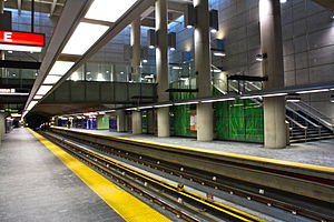
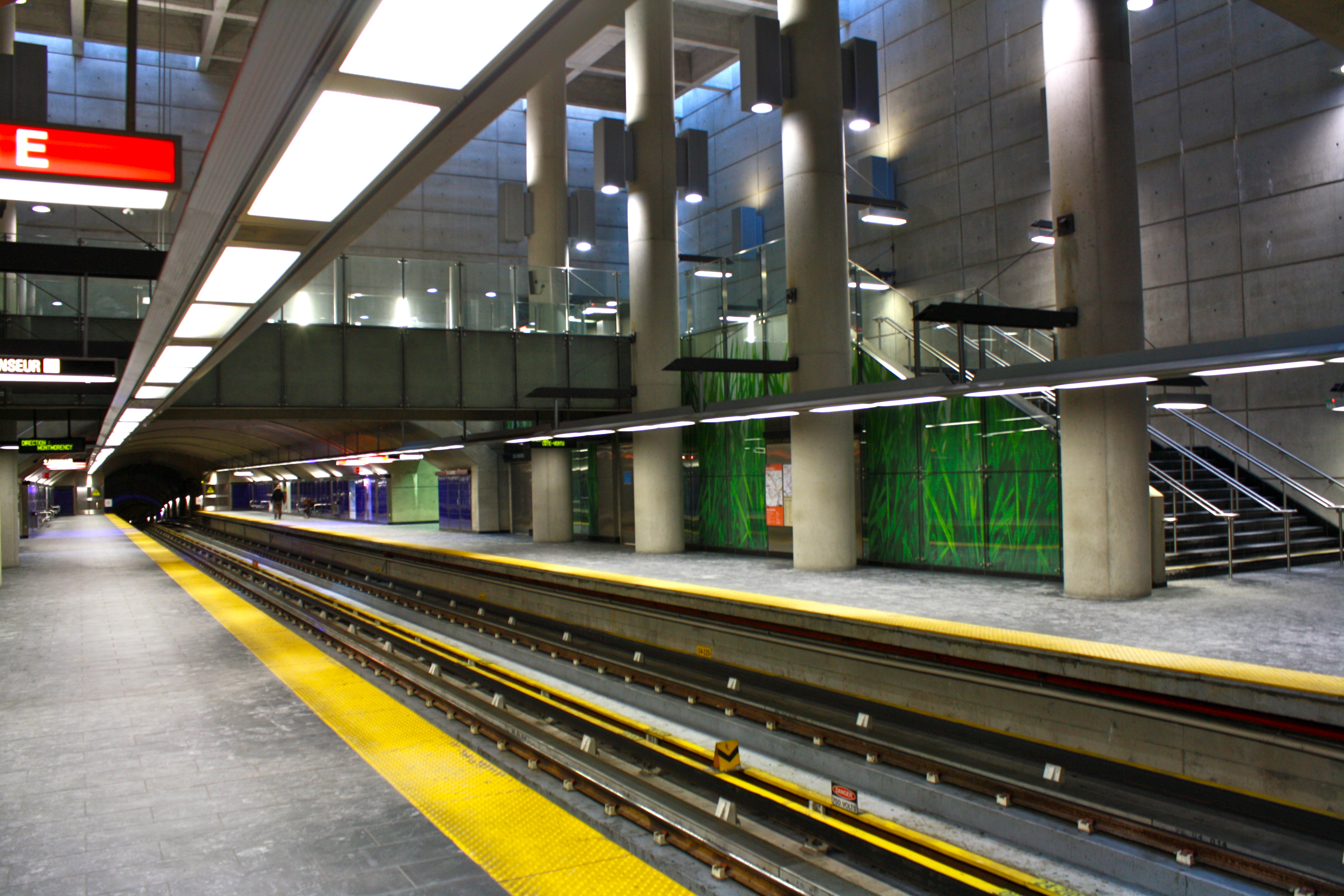
 A train stop at De La Concorde station.
The metro station is a side platform station, built in tunnel with an open-pit central section in the shape of a cube. The upper surface of the cube protrudes out of the earth and is rimmed with skylights, producing a sundial-like effect as the progress of the sun changes the light within the cube. The station's decor is primarily bare concrete, metal, and steel, with the platform's ultramarine tiles and enlarged photographs of grass providing colour.
The escalator shaft from the entrance building to the ticket hall also protrudes out of the earth as a glazed cylinder reminiscent of Norman Foster's "fosterito" metro entrances in the Bilbao metro. The entrance building is split-level, one level providing access to the metro station and the other to the train station; its glazed front is decorated with a large metro logo.
The train station is located at an upper level and the platforms continue onto a viaduct over Boul. de la Concorde. Also at this level is a park and ride loop and bicycle trail access.
The area to the east of the station entrance is landscaped, with benches and a terrace provided on top of the station cube. The footpath leading to the station is the site of the station's artwork, Nos allers-retours by Yves Gendreau. The sculpture is a series of tangled metal tubes, in the colours of the metro lines plus purple for the commuter trains, atop a series of poles, representing the paths taken by the users of public transit.
Origin of name
The station is named after boulevard de la Concorde, which in turn is named for the Place de la Concorde in Paris.
Connecting bus routes
Société de transport de Laval (STL)
STL Regular routes No. Route Description Route Map Schedule 33 Metro Montmorency - Metro Cartier Map Schedule 37 Industrial Park Centre - Metro Cartier Map Schedule 42 Terminus Le Carrefour - Saint-François Map Schedule STL Night routes No. Route Description Route Map Schedule 2 Night route between Henri-Bourassa via
Metro Cartier and Metro MontmorencyMap Schedule - Route 2 offers a late night and early morning connection between Metro Montmorency and Henri-Bourassa , Monday to Saturday only.
Nearby points of interest
- Parc Montmorency
See also
References
External links
- Pictures of the new Laval Metro - (English)
- Interactive STL map
- Interactive map of Laval
- Shows both the borders and names of the 14 former municipalities (purple) and the borders only of the
current 6 sectors (maroon), tick off both boxes
beside "Limite administrative".
- Shows both the borders and names of the 14 former municipalities (purple) and the borders only of the
- Metro Map
Line 1 Green Angrignon • Monk • Jolicoeur • Verdun • De L'Église • LaSalle • Charlevoix • Lionel-Groulx • Atwater • Guy-Concordia • Peel • McGill • Place-des-Arts • Saint-Laurent • Berri-UQAM • Beaudry • Papineau • Frontenac • Préfontaine • Joliette • Pie-IX • Viau • Assomption • Cadillac • Langelier • Radisson • Honoré-BeaugrandLine 2 Orange Côte-Vertu • Du Collège • De La Savane • Namur • Plamondon • Côte-Sainte-Catherine • Snowdon • Villa-Maria • Vendôme • Place-Saint-Henri • Lionel-Groulx • Georges-Vanier • Lucien-L'Allier • Bonaventure • Square-Victoria • Place-d'Armes • Champ-de-Mars • Berri-UQAM • Sherbrooke • Mont-Royal • Laurier • Rosemont • Beaubien • Jean-Talon • Jarry • Crémazie • Sauvé • Henri-Bourassa • Cartier • De La Concorde • MontmorencyLine 4 Yellow Line 5 Blue Snowdon • Côte-des-Neiges • Université-de-Montréal • Édouard-Montpetit • Outremont • Acadie • Parc • De Castelnau • Jean-Talon • Fabre • D'Iberville • Saint-MichelCoordinates: 45°33′39.06″N 73°42′34.84″W / 45.56085°N 73.7096778°W
Categories:- Montreal Metro Orange Line
- Transportation in Laval, Quebec
- Rapid transit stubs

Wikimedia Foundation. 2010.