- Newfoundland and Labrador Route 1
-
Route 
Highway system Highways in Newfoundland and Labrador
← Route 520 Route 2 → Route 1 is a Canadian highway in the province of Newfoundland and Labrador.
Also carrying the designation Trans-Canada Highway in the province, Route 1 is the primary east-west surface road on the island of Newfoundland.
The eastern terminus of Route 1 is St. John's. From there, the highway crosses the island 903 kilometres (561 mi) to Channel-Port aux Basques, its western terminus.
From there, the Trans-Canada Highway is carried across the Cabot Strait by ferry to North Sydney, Nova Scotia.
Route description
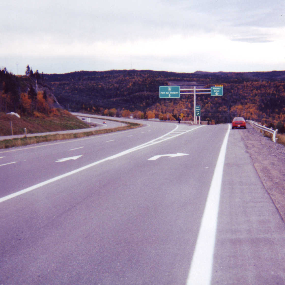
 Trans Canada Highway Route 1 at Corner Brook. This is a 4-lane section at this point in the highway's 903-kilometre length.
The following description details the highway from its eastern terminus to its western terminus.
Route 1's official eastern terminus is at the interchange with Logy Bay Road in the northeastern part of the city. The highway proceeds west on the Outer Ring Road, a 4-lane expressway. Route 1 maintains the name Outer Ring Road, intersecting with St. John's roads such as Aberdeen Avenue, Portugal Cove Road, Torbay Road, Allandale Road, Thorburn Road, Topsail Road and Kenmount Road until the interchange with Pitts Memorial Drive, 20 km to the west.
Route 1 proceeds in a generally southeastern direction for another 25 km as it follows the southern shore of Conception Bay (several kilometres inland) until it reaches the interchange with Route 13 where it turns west and then northwest, continuing for another 29 km on a 4-lane expressway to Whitbourne where the divided highway ends at the interchange with Route 80/81.
Route 1 transitions to a 2-lane controlled access highway and continues northwest from Whitbourne along the isthmus of the Avalon Peninsula and 188 km north to Glovertown, bypassing Clarenville, small communities like Arnold's Cove, Goobies and passing through Terra Nova National Park; park admission is not required to use Route 1. The Bonavista Peninsula and Burin Peninsula can be accessed via interchanges near Clarenville and Goobies, respectively.
From Glovertown, the highway proceeds northwest 182 km to Badger, bypassing Gander, Glenwood. Lewisporte (about 11 km north on Route 340), Norris Arm Bishop's Falls and Grand Falls-Windsor; Route 1 has a 6 km 4-lane section through Grand Falls-Windsor. As of August 2008, there are no gas stations along the highway between the towns of Gander and Bishop's Falls. The Isles of Notre Dame region of the province, which includes Fogo, the Twillingate Islands, New World Island and surrounding areas, can be accessed via Route 340 at the Notre Dame Junction interchange near Lewisporte, Newfoundland and Labrador. The Bay d'Espoir region can be accessed via the Bay D'Espoir highway near Botwood. Botwood, Point Leamington and Leading Tickles can be accessed via the Botwood Highway, officially Route 350 at an interchange in the Bishop's Falls-Grand Falls-Windsor area.
From Badger, Route 1 heads due north for 64 km to Springdale where the highway swings southwest for 137 km to Pasadena, passing through Deer Lake.
At Pasadena, the highway transitions to a 4-lane expressway and continues southwest along the south shore of Deer Lake before following the Humber River through the narrow Humber Valley. The 4-lane section proceeds for 29 km in a southwest direction, where it transitions back to a 2-lane controlled access highway west of the interchange with Confederation Drive, southwest of Corner Brook.
From the Confederation Drive interchange, Route 1 proceeds for 213 km in a southwest direction, bypassing Stephenville (accessible via Route 460 and Route 490) and passing through the Codroy Valley (where it is a 2-lane uncontrolled access highway) to Port aux Basques. It terminates southeast of the town at the Marine Atlantic ferry terminal.
New alignment
New highway construction during the 1990s extended Route 1 on what is called the Outer Ring Road to the interchange with Logy Bay Road in the northeast part of St. John's. Prior to this construction, Route 1 and the Trans-Canada Highway designation began at St. John's City Hall on New Gower Street and proceeded west on Pitts Memorial Drive and then on the current alignment of Route 1 to the southwest. It is for this reason that the city named its hockey arena and convention centre Mile One Centre, adjacent to the city hall.
To follow an unofficial alignment of Route 1 from St. John's City Hall, one must head geographically east for 1.5 km into the southeastern part of the city, continuing onto Duckworth Street (Route 60). Proceed north for 1 km on Ordnance Street and King's Bridge Road before turning east for 1.5 km along the north shore of Quidi Vidi Lake on The Boulevard.
Continue north on East White Hills Road, which becomes controlled access several hundred metres north of its intersection with The Boulevard. The East White Hills Road transitions into the Outer Ring Road 4 km to the north at the interchange with the Logy Bay Road.
Exit list
Location km Exit Intersecting Roads Notes Port aux Basques 1 1 Route 470 Stephenville Crossing 144 2 Route 490 – Stephenville Trout Brook 168 3 Route 460 (White's Road, Hansen Highway) – Stephenville Corner Brook 212 4 Route 450 (Lewin Parkway) 215 5 Massey Drive 217 6 Lewin Parkway 221 7 Route 440 (Riverside Drive) Steady Brook 224 8 Marble Drive Marble Mountain Humber Village 230 9 Marble Drive Little Rapids 234 10 Bonnell Drive 237 11 Berkshire Road Pasadena 241 12 Main Street 244 13 Stentaford Avenue St. Jude's 260 14 Ridgeview Road Deer Lake 264 15A Glide Lake Road 265 15 High Street 267 16 Route 430 Grand Falls-Windsor 474 17 Main Street 477 18 Cromer Avenue 478 19 Union Street 479 20 Scott Avenue Bishops Falls 491 21 Main Street 495 22 Route 350 Notre Dame Junction 526 23 Route 340 – Lewisporte, Twillingate Gambo 612 24 Route 320 Glovertown 629 25 Route 310 George's Brook 701 26 Route 230 – Bonavista Peninsula Whitbourne 816 27 Route 100 – Placentia 817 28 Route 80 Baccalieu Trail Ocean Pond 827 29 Ocean Pond Road Grand Pond 830 30 Route 71 (Hodgewater Line) Roaches Line 834 31 Route 75 (Veterans Memorial Hwy.) Baccalieu Trail Brigus Junction 837 32 Brigus Junction Road Middle Gull Pond 842 33 Middle Gull Pond Road Avondale 844 34 Route 63 Holyrood 848 35 Route 90 856 36 Route 62 Butter Pot 858 37 Route 13 (Witless Bay Line) – Bay Bulls 862 38 Butter Pot Provincial Park Conception Bay South 875 39 Route 61 (Foxtrap Access Road) St. John's 880 40 Paddy's Pond/Cochrane Pond 886 41 Route 2 (Pitts Memorial Drive) 888 42 Kenmount Road 889 43 Route 60 (Topsail Road) 893 44 Route 50 (Thorburn Road) 895 45 Route 3A (Team Gushue Highway) 899 46 Allandale Road 901 47 Route 40 (Portugal Cove Road) 902 48 Route 20 (Torbay Road) 903 49 Aberdeen Avenue, Stavanger Drive 905 50 Route 30 (Logy Bay Road) 1.000 mi = 1.609 km; 1.000 km = 0.621 mi Preceded by
NS Highway 105Trans-Canada Highway
NL Route 1Succeeded by
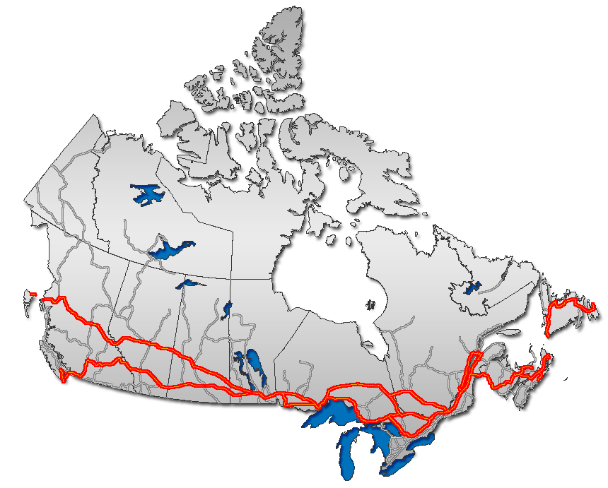
terminus Portions of the Trans-Canada Highway
 British Columbia: Highway 1 • Highway 5 • Highway 16 | Alberta: Highway 1 • Highway 16
Saskatchewan: Highway 1 • Highway 16 | Manitoba: Highway 1 • Highway 16 • Highway 100
Ontario: Highway 17 • Highway 69 • Highway 400 • Highway 12 • Highway 7 • Highway 71 • Highway 11 • Highway 66 • Highway 417
Quebec: Autoroute 40 • Autoroute 25 • Autoroute 20 • Autoroute 85 • Route 185 • Route 117 • Autoroute 15
New Brunswick: Route 2 • Route 16 | Confederation Bridge | Prince Edward Island: Route 1 | Nova Scotia: Highway 104 • Highway 105 • Highway 106
Newfoundland: Route 1Categories:- Roads in Newfoundland and Labrador
- Trans-Canada Highway
Wikimedia Foundation. 2010.