- Deer Lake, Newfoundland and Labrador
-
Deer Lake — Town — The sun sets over Deer Lake, Newfoundland, June 2003.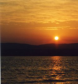
SealLocation of Deer Lake in Newfoundland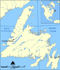
 Deer Lake
Coordinates: 49°10′28″N 57°25′37″W / 49.17444°N 57.42694°W Country  Canada
Province  Newfoundland and Labrador
Census division 5 Settled 1864 Incorporated 1951 Government – Type Liberal - M.H.A Dwight Ball – Mayor Dean Ball Area – Total 73.23 km2 (28.3 sq mi) Elevation 30 m (98 ft) Population (2006) – Total 4,827 – Density 65.9/km2 (170.7/sq mi) Time zone Newfoundland Time (UTC-3:30) – Summer (DST) Newfoundland Daylight (UTC-2:30) Postal code span A8A Area code(s) 709 Highways Route 1 Website Official web site Deer Lake is a Canadian town in the western part of the island of Newfoundland in the province of Newfoundland and Labrador.
The town derives its name from Deer Lake and is situated at the outlet of the upper Humber River at the northeastern end of the lake.
Contents
History
The first settlers in the area arrived from Cape Breton Island in Nova Scotia in 1864. Originally loggers and trappers, the settlers later took up farming.
In 1922, a work camp was set up to support the International Pulp and Paper company. The camp would later become the town of Deer Lake. A formal townsite was constructed in 1925 and included a railroad terminal, churches and a small hospital. The town was incorporated in 1951.
The airport was built in 1955 and is one of the town's major employers. In 2004, Deer Lake Regional Airport began plans to redesign the airport terminal, completed in June 2007. The primary population that the airport serves is approximately 55,000. The effect was from Rocky Harbour to Corner Brook and around Deer Lake.
Economy
The town is located in Division No. 5 and is the gateway to the Great Northern Peninsula, owing to an important highway interchange on the Trans-Canada Highway. It is the closest major community to Gros Morne National Park and is home to the Deer Lake Regional Airport.
A hydroelectric plant was established on the Humber River in 1925 to provide electricity to a pulp and paper paper mill in Corner Brook.
Demographics
Population, 2006: 4,827[1]
Population, 2001: 4,769
2001 to 2006 population change: 1.2 percent
Number of dwellings: 1,470
Land (square kilometers): 73.23
Climate
Climate data for Deer Lake Month Jan Feb Mar Apr May Jun Jul Aug Sep Oct Nov Dec Year Record high °C (°F) 14
(57)14
(57)19
(66)23
(73)28
(82)31.7
(89.1)35.6
(96.1)32.2
(90.0)29
(84)23.3
(73.9)21.1
(70.0)16.7
(62.1)35.6
(96)Average high °C (°F) −3.3
(26.1)−3.9
(25.0)0.7
(33.3)6
(43)12.5
(54.5)18.1
(64.6)22
(72)21.3
(70.3)16.4
(61.5)10
(50)4.5
(40.1)−0.5
(31.1)8.6 Average low °C (°F) −11.8
(10.8)−13.6
(7.5)−8.9
(16.0)−2.6
(27.3)1.6
(34.9)6.4
(43.5)11
(52)10.9
(51.6)7
(45)2.3
(36.1)−1.9
(28.6)−7.7
(18.1)−0.6 Record low °C (°F) −33.9
(−29.0)−37.2
(−35.0)−35
(−31)−22
(−8)−10.6
(12.9)−4.4
(24.1)−0.6
(30.9)−2.2
(28.0)−5
(23)−10.5
(13.1)−20.6
(−5.1)−29.4
(−20.9)−37.2
(−35.0)Precipitation mm (inches) 107.5
(4.232)72.7
(2.862)78.2
(3.079)72.6
(2.858)85.1
(3.35)87.4
(3.441)95.8
(3.772)105.3
(4.146)102.3
(4.028)114.8
(4.52)106.7
(4.201)98.8
(3.89)1,127.3
(44.382)Source: Environment Canada[2] See also
References
- ^ Population and dwelling counts
- ^ Environment Canada Canadian Climate Normals 1971–2000, accessed 15 July 2009
External links
 Subdivisions of Newfoundland and Labrador
Census divisions Cities Other communities Bishop's Falls · Bonavista · Botwood · Carbonear · Channel – Port aux Basques · Clarenville · Conception Bay South · Deer Lake · Ferryland · Fogo · Gander · Grand Bank · Grand Falls-Windsor · Happy Valley – Goose Bay · Harbour Grace · Hopedale · Labrador City · Marystown · Nain · Norris Arm · Pasadena · Peterview · Placentia · Red Bay · St. Anthony · Stephenville · Twillingate · Torbay · Woody Point · Makkovik Category:Newfoundland and Labrador ·
  Portal:Newfoundland and Labrador ·
  WikiProject:Newfoundland and Labrador
Coordinates: 49°10′28″N 57°25′37″W / 49.17444°N 57.42694°W
Categories:- Towns in Newfoundland and Labrador


Wikimedia Foundation. 2010.