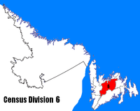
Division No. 6, Newfoundland and Labrador
- Division No. 6, Newfoundland and Labrador
-
Division No. 6 is a census division in the central part of the island of Newfoundland in the province of Newfoundland and Labrador, Canada. It is divided into 16 parts; 12 towns and four unorganized subdivisions.
The division had a population of 36,208 in both the Canada 2001 Census and the Canada 2006 Census. It was the only census division in Canada to report exactly the same population in both censuses.
Contents
Towns
Unorganized Subdivisions
Wikimedia Foundation.
2010.
Look at other dictionaries:
Division No. 8, Newfoundland and Labrador — Division No. 8 is a census division on the north coast of the island of Newfoundland in the province of Newfoundland and Labrador, Canada. It has a land area of 9,315.44 km² (3,596.71 sq mi) and a population of 42,188 as of the 2001 census.… … Wikipedia
Division No. 1, Newfoundland and Labrador — is a census division covering the entire Avalon Peninsula including the Isthmus of Avalon of the Canadian province of Newfoundland and Labrador. Like all census divisions in Newfoundland and Labrador, but unlike the census divisions of some other … Wikipedia
Division No. 5, Newfoundland and Labrador — Census Division No. 5 is a Statistics Canada statistical division composed of the areas of the province of Newfoundland and Labrador called Humber Valley, Bay of Islands, and White Bay. It covers a land area of 10,365.63 km² (4,002.19 sq mi) … Wikipedia
Division No. 9, Newfoundland and Labrador — Census Division No. 9 is composed of the area of the province of Newfoundland and Labrador called the Northern Peninsula. It has a land area of 13,526.85 km² (5,222.75 sq mi) and a population of 20,091 as of the 2001 census. The largest… … Wikipedia
Division No. 4, Newfoundland and Labrador — Census Division No. 4 is a Statistics Canada statistical division that comprises the areas of the province of Newfoundland and Labrador called St. George’s Stephenville. It covers a land area of 7087.70 km² and had a population of 22,162 as… … Wikipedia
Division No. 10, Newfoundland and Labrador — Census Division No. 10 is composed of the area of the province of Newfoundland and Labrador, Canada, called Labrador outside of Nunatsiavut. It has a land area of 269,073.3 km² (103,889.78 sq mi) and, as of the 2001 census, has a… … Wikipedia
Division No. 11, Newfoundland and Labrador — Census Division No. 11 is composed of the Nunatsiavut area of the province of Newfoundland and Labrador, Canada. Division 11 was used for the first time in the Canada 2006 Census; prior to 2006, Nunatsiavut was counted as part of Division 10. The … Wikipedia
Division No. 4, Subd. A, Newfoundland and Labrador — Division No. 4, Subd. A is an unorganized subdivision on the Southwest coast of the island of Newfoundland in Newfoundland and Labrador, Canada. It is in Division No. 4. According to the 2006 Statistics Canada Census:[1] Population: 1708 % Change … Wikipedia
Division No. 4, Subd. B, Newfoundland and Labrador — Division No. 4, Subd. B is an unorganized subdivision on St. George’s Bay on the island of Newfoundland in Newfoundland and Labrador, Canada. It is in Division No. 4. According to the 2006 Statistics Canada Census:[1] Population: 1399 % Change… … Wikipedia
Division No. 4, Subd. C, Newfoundland and Labrador — Division No. 4, Subd. C is an unorganized subdivision on St. George’s Bay on the island of Newfoundland in Newfoundland and Labrador, Canada. It is in Division No. 4. According to the 2001 Statistics Canada Census:[1] Population: 845 % Change… … Wikipedia
 Subdivisions of Newfoundland and Labrador
 Category:Newfoundland and Labrador ·
  Portal:Newfoundland and Labrador ·
  WikiProject:Newfoundland and LabradorCategories:
