- Placentia, Newfoundland and Labrador
-
Placentia
Pleasure
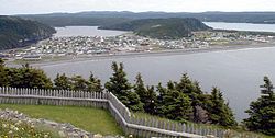
Plaisance— Town — Panorama of Placentia
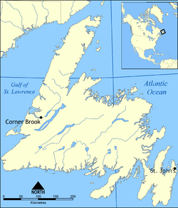
SealLocation of Placentia in Newfoundland Coordinates: 47°14′45″N 53°57′40″W / 47.24583°N 53.96111°W Country  Canada
Province  Newfoundland and Labrador
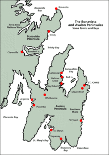
Settled early 16th century Population (2006) - Total 3,898 Time zone Newfoundland Time (UTC-3:30) - Summer (DST) Newfoundland Daylight (UTC-2:30) Area code(s) 709 Website Official Town Website Placentia is a town on the Avalon Peninsula, Newfoundland and Labrador, consisting of the amalgamated communities of Jerseyside, Townside, Freshwater, Dunville and Argentia. Common family names include Caul, Nolan, Power, O'Keefe, Collins, O'Reilly, Murphy, Williams, Gambin, Hatfield, Wyse, Barry, Mooney, and Careen.
In the 2006 census, Placentia's population was reported as 3,898, down significantly from the 2001 figure of 4,426.[1] This population decline has been ongoing since the early 1990s; in the 1996 census, Placentia was, proportionately, the 2nd fastest shrinking town in Canada,[2] dropping from 5,515 to 5,013 between 1991 and 1996.
Contents
History
It is unclear when Placentia was first settled by Europeans, but Basque fishermen were fishing in the area as early as the beginning of the 16th century, using Placentia as a seasonal centre of operations. Plazenta meaning pleasantness in the Basque language, derived from the Latin placentia is probably a name given by the Basques.[3] Placentia's large, rocky beach meant that fish could be salted and dried on the beachrocks rather than on a constructed wooden fishing stage, saving both time and effort.
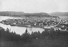
In 1655, the French, who controlled more than half of the island of Newfoundland, and most of Atlantic Canada, made Placentia (or 'Plaisance,' as they called it) their capital. The French colony at Placentia was a successful one, and launched from here the devastating raids on the English during the Avalon Peninsula Campaign (1696). Fort Royal was built here.
In 1713, the Treaty of Utrecht forced the French to abandon their Placentia Bay settlements, and Placentia became a British possession. For a time in the 18th century, it still rivaled St. John's in size and importance, as evidenced by the future King William IV's summering at Placentia in 1786 and using it as his base of operations when acting as surrogate judge in Newfoundland.[4] The town was described by the then-Prince as "a more decent settlement than any we have yet seen in Newfoundland" and was reported as having a population between 1500 and 2000 people.[4] Considering that the population of Newfoundland was reported as 8,000 11 years earlier, in 1775, Placentia's relative size and importance becomes apparent.
By the 19th century, it was more fully eclipsed by St. John's and Harbour Grace, Placentia continued to be an important town, regional centre to the southern Avalon peninsula and the eastern Burin peninsula.
From the mid-18th century through to the 1830s, numerous Irish immigrants from Waterford, Wexford, Kilkenny and Cork settled in Placentia, so that the population of the modern town is largely of a mixture of West Country English and South-eastern Irish background. In the 18th century there were also a large number of settlers from the Channel Islands, from which Jerseyside, a prominent section of the town, derives its name.
In 1940, via an agreement between the British and American governments (Newfoundland not joining Canada until 1949), a large American military base was constructed at nearby Argentia (which is now within the town of Placentia's boundaries). For a time, this was the largest American military base outside of the United States, and it played an integral role in World War II, earning the nickname "the Gibraltar of the Atlantic."
This huge development revolutionized the Placentia area both economically and culturally. Essentially, the American base introduced a widespread cash-based economy. Suddenly, people who had fished all of their lives (engaging in a type of barter system called the truck system) had access to good-paying jobs on the American base. American technology enriched the living standards of Placentia residents, while the local culture was influenced strongly by the American presence. Similarly, it prompted a huge population boom, growing from 1,900 people in 1935[5] to well over 8,000 in the 1960s (note: these figures account for the current boundaries of Placentia, which at the time consisted of 4 separate towns: Placentia, Dunville, Jerseyside, and Freshwater).
The post office was established in 1851. The first Postmistress in 1863 was Mary Morris.
Economy
The American base at Argentia was scaled back in the 1970s, and closed totally in 1994. This, along with the cod moratorium introduced by the Canadian government a few years' earlier, left the town of Placentia without an economic base for some time, although recent developments by Vale Inco are beginning to stabilize the town's rocky economic situation.
Education
Placentia is home to two primary education schools: St. Edward's Elementary, a K-8 school located in Placentia proper, which schools children from the sections of Placentia, Jerseyside, Ferndale, Southeast, Bonds Path, Point Verde, and Barasway. There is also St. Anne's Academy, a K-9 school in Dunville for students from Dunville, Freshwater, Fox Harbour, and Ship Harbour. There currently exists one high school, Laval High School, which educates students from all parts of the amalgamated communities for grades 9 to 12. Laval recently celebrated its 40th anniversary with a full reunion of all graduates, and is preparing for construction of a new high school, scheduled to open in September 2010. All schools are home to many extracurriculars, including student council, sports, drama and music, and volunteer organizations.
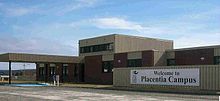
Placentia is also home to a post-secondary institution; a campus of the College of the North Atlantic, offering programs in adult basic education, college transition, heavy duty equipment technique, heavy equipment operation, welding, machinist, and industrial machinery.
Tourism and culture
Placentia has many features that make is a popular tourist attraction in Newfoundland and Labrador. It has a unique lift-bridge that spans the tumultuous tides of 'the gut' (the narrow opening to the harbour). There are many archaeological sites (some partially re-constructed), several excellent examples of late-19th century Newfoundland architecture, two museums (O'Reilly House and Castle Hill), and one of the two Marine Atlantic ferry links from Newfoundland to Nova Scotia (via Argentia). It is 130 kilometres from the capital city, St. John's, and is within easy distance of the scenic Cape Shore (including the Cape St. Mary's Ecological Reserve), the Irish Loop and St. Mary's Bay, Conception Bay, and the inner reaches of Placentia Bay.
In 2009, Placentia celebrated the opening of its Cultural Arts Center with a month of artistic events, including drama productions, art exhibitions (three shows recognizing art from elementary students, high school students, and adults), and musical performances.
The town has an established summer stock theatre troupe, Placentia Area Theatre D'Heritage (PATH),[6] which performs historical plays of significance in the Placentia area. The primary production is Faces of Fort Royale, performed at Castle Hill National Historic Site, depicting the lives of the early inhabitants of Placentia under the leadership of Governor De Broullion. They also perform a dinner theatre cabaret set in the 1950s during the Argentia Base heyday, and a ghost walk. The troupe generally consists of post-secondary students under the direction of the province's finest theatre producers.
Several natives of the Placentia area have gone on to distinguish themselves in the world at large. These include commentator and journalist Rex Murphy (born in Carbonear but raised in the area), poet and playwright Agnes Walsh, lyric poet and influential Confederate Greg Power, Newfoundland's first professional bodybuilder, Frank McGrath,professional wrestler and Alastair Ralphs (Total Nonstop Action Wrestling).
See also
- List of cities and towns in Newfoundland and Labrador
- Newfoundland Railway
- Dunville, Newfoundland and Labrador
References
- ^ 2006 Community Profiles - Census Subdivision
- ^ Census Subdivisions (Municipalities) With the Greatest Percentage Population Decline (3), 1991 and 1996 Censuses - 100% Data
- ^ Based on a map by Gérard Galliene (Quebec), illustrating the Les Basques dans l'estuaire du Saint-Laurent by René Belanger. 1971. Les Presses de l'Université du Québec. ISBN 0-7770-0026-1
- ^ a b "Prince William Henry in Newfoundland" by Hans Rollmann
- ^ The Placentia Area Blog: Population Changes
- ^ Placentia Area Theatre d'Heritage Inc.
External links
- Town of Placentia's official site
- Placentia Area Event Calendar on placentiabay.ca
- The Charter, Placentia's local newspaper
- Placentia Area Historical Society
 Subdivisions of Newfoundland and Labrador
Census divisions Cities Other communities Bishop's Falls · Bonavista · Botwood · Carbonear · Channel – Port aux Basques · Clarenville · Conception Bay South · Deer Lake · Ferryland · Fogo · Gander · Grand Bank · Grand Falls-Windsor · Happy Valley – Goose Bay · Harbour Grace · Hopedale · Labrador City · Marystown · Nain · Norris Arm · Pasadena · Peterview · Placentia · Red Bay · St. Anthony · Stephenville · Twillingate · Torbay · Woody Point · Makkovik Category:Newfoundland and Labrador ·
  Portal:Newfoundland and Labrador ·
  WikiProject:Newfoundland and Labrador
Topics of New France Subdivisions Acadia (1604–1713) • Canada (1608–1763) • Louisiana (1699–1763, 1800–1803) • Newfoundland (1662–1713) • Île Royale (1713–1763)
Towns Acadia (Port Royal) • Canada (Quebec, Trois-Rivières, Montreal, Détroit) • Île Royale (Louisbourg) • Louisiana (Mobile, New Orleans) • Newfoundland (Plaisance) • List of townsForts Fort Rouillé • Fort Michilimackinac • Fort de Buade;• Fort de Chartres • Fort Detroit • Fort Carillon • Fort Condé • Fort Duquesne • Fortress of Louisbourg • Castle Hill • List of FortsGovernment Canada (Governor General, Intendant, Sovereign Council, Bishop of Quebec, Governor of Trois-Rivières, Governor of Montreal) • Acadia (Governor, Lieutenant-General) • Newfoundland (Governor, Lieutenant-General) • Louisiana (Governor, Intendant, Superior Council) • Île Royale (Governor, Intendant, Superior Council)Justice Intendancy • Superior Council • Admiralty court • Provostship • Officiality • Seigneurial court • Attorney • Bailiff • Maréchaussée • Code NoirEconomy Society Religions War & Peace Intercolonial Wars • French and Iroquois Wars • Great Upheaval • Great Peace of Montreal • Schenectady massacre • Deerfield massacreRelated Coordinates: 47°14′45″N 53°57′40″W / 47.24583°N 53.96111°W
Categories:- Populated coastal places in Canada
- Towns in Newfoundland and Labrador
Wikimedia Foundation. 2010.

