- Perimeter Highway (Winnipeg)
-
For other meanings of Perimeter Highway, see Perimeter Highway (disambiguation).
 Portage Ave interchange
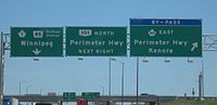
Provincial Trunk Highways (PTH) 100 and 101 (locally known as the Perimeter Highway) form a beltway around Winnipeg, Manitoba. The Perimeter is approximately 90 km (56 mi) long. It is an alternate route around Winnipeg for through traffic, as there are no freeways through the city.
Contents
History
The highway was originally built in 1955, following the cancellation of a freeway system to accommodate traffic around Winnipeg to avoid the city centre rush hour traffic. The northeast section was left unbuilt at the time, as PTH 59 had received significant upgrades, making the need for a northeast section less pressing. PTH 59 continued to serve as the de facto northeast leg of the Perimeter until the mid-1990s, when the remaining segments of the highway were completed. The highway now encircles Winnipeg.
Most of the Perimeter is a four-lane divided expressway, with interchanges and at-grade intersections. The only section that remain two-lane is in the vicinity of the PTH 59N interchange.
The southern segment of the Perimeter Highway is part of the Trans-Canada Highway, and is designated as Highway 100. The northern segment is a provincial highway designated as PTH 101.
The Perimeter Highway bridge across the Red River and roadway at Pembina Highway was constructed in 1958. The job was tendered to Peter Leitch Construction Ltd. at a cost of $188,670. In December 1957, Dominion Bridge was awarded the contract ($80,157) to supply the structural steel for the overpass.[1]
Exit list
km # Destinations Notes 0 1  PTH 1 (TCH) / Route 135 west (Fermor Avenue) – Kenora
Signed as exits 1A (west) and 1B (east) The Perimeter Highway designation is Hwy 100 south of here and Hwy 101 north of here.
2.0 Murdock Road At-grade 3.6 Symington Road At-grade 5.2 Plessis Road At-grade 6.8 8  PTH 59 / Route 20 north (Lagimodiere Boulevard) – St. Pierre-Jolys
Signed as exit 8 7.9 Melnick Road (north) / Budd Road (south) At-grade 8.0 Canadian Pacific Railway Level crossing 8.1 Aimes Road (north) / Sumka Road (south) At-grade 8.8 PR 300 south / Route 150 north (St. Anne's Road) At-grade / Traffic Signals 12.4 PR 200 south / Route 52 north (St. Mary's Road) – St. Adolphe At-grade / Traffic Signals 15.9 18  PTH 75 south / Route 42 north (Pembina Highway) – Emerson
Signed as exits 18A (north) and 18B (south) 16.2 Canadian National Railway Level crossing 17.2 Route 80 north (Waverley Street) At-grade / Traffic Signals 20.2 Brady Road At-grade 21.4 PR 330 south – La Salle, Morris At-grade 21.9 Canadian Pacific Railway Level crossing 23.1 Municipal Road 9E At-grade 24.7 Municipal Road 8E At-grade 26.4 Municipal Road 7E At-grade 26.8  PTH 2 west – Elm Creek
At-grade 28.0  PTH 3 west / Route 155 east (McGillivray Boulevard) – Carman
At-grade / Traffic Signals 29.8 Oakland Road At-grade 30.2 Central Manitoba Railway (CEMR) Level crossing 30.7 La Verendrye Road At-grade 35.3 PR 427 west / Route 145 east (Wilkes Avenue) 36.1 At-grade 37.2 Caron Road (west) No access when traveling northbound (clockwise) At-grade 38.1 40 PR 241 west / Route 105 east (Roblin Boulevard) – Headingley Signed as exit 40 clockwise Signed as exits 40A (east) and 40B (west) counterclockwise
38.6 Assiniboine River 39.3 Augier Ave (east) No access when traveling southbound (counter-clockwise) Oak Forest Cres (west) No access when traveling northbound (clockwise)
At-grade 40.0 42 PTH 1 (TCH) / Route 85 east (Portage Avenue) – Portage La Prairie, BrandonSigned as exits 42A (east) and 42B (west) The Perimeter Highway designation is Hwy 100 south of here and Hwy 101 north of here.
40.7 Assiniboia Downs (west) Maybe no access when traveling northbound (clockwise) At-grade 42 PR 425 (Saskatchewan Avenue) At-grade / Traffic Signals 42 Canadian Pacific Railway Level crossing 43.1 Paddock Road At-grade 44.0 Boychuk Road At-grade 45.6 Selkirk Avenue, Township Road 63 At-grade 47.3 Township Road 64 At-grade 48.5 PR 221 west / Route 25 east (Inkster Boulevard) – Rosser 51.2 At-grade 51.3 Canadian National Railway Level crossing 52.1  PTH 6 north (Paterson Drive) – Grand Rapids, Thompson
At-grade / Traffic Signals 52.9 Summit Road At-grade 54.6 Sturgeon Road At-grade 56.2 Klimpke Road At-grade 57.9  PTH 7 north / Route 90 south (Brookside Boulevard) – Stonewall
59.5 King Edward Street At-grade 59.8 Canadian Pacific Railway Level crossing 62.8 PR 409 north (Pipeline Road) At-grade / Traffic Signals 65.5 Second Street (south) / Holmes Road (north) 66.8 69  PTH 8 north / Route 180 south (McPhillips Street) – Gimli
Signed as exits 69A (south) and 69B (north) 69.0 Canadian Pacific Railway Level crossing 69.6 71  PTH 9 north / Route 52 south (Main Street) – Selkirk, Winnipeg Beach
Signed as exits 71A (south) and 71B (north) 70.3 Red River 70.7 72 PR 204 north / Route 42 south (Henderson Highway) – Lockport Signed as exit 72 72.5 Raleigh St (south) No access when traveling westbound (counter clockwise) / Sperring Ave (north) No access when traveling eastbound (clockwise) At-grade 73.8 PTH 59 / Route 20 south (Lagimodiere Boulevard) – Grand BeachAt-grade / Traffic signals 76.2 Wenzel Street At-grade 77.0 Central Manitoba Railway (CEMR) Level crossing 80.2 Gunn Road At-grade 83.5 Canadian Pacific Railway Level crossing 83.6  PTH 15 east / Route 115 west (Dugald Road) – Dugald
At-grade / Traffic Signals 85.3 St. Boniface Road At-grade 87.0 Niakwa Road At-grade 87.2 Great Winnipeg Water District Railway (GWWDRR) Level crossing 88.6 Navin Road At-grade 89.5 1 PTH 1 (TCH) / Route 135 west (Fermor Avenue) – Kenora, OntarioThe Perimeter Highway designation is Hwy 100 south of here and Hwy 101 north of here. Inner city beltway, the second half of the Perimeter plan
This roadway is what was to be part of a two ring road system. That being, the outer Perimeter Highway, and an inner ring. The inner ring was initially tabled in the 1960s and was slow to progress.
The inner ring, also sometimes referred to as the inner city beltway, was to be (Route 17) the Chief Peguis Trail to the north, heading west to Route 96 (the Moray Bridge), circling to Route 165 (Bishop Grandin Blvd), and from there to a point near Northern Blower on Route 37 (Regent). Several years ago a group working with a councellor, worked to stop the loop from going into the Transcona area, and had the roadway's land designated a natural prairie grass park. From this point on Regent, the road was supposed to loop north back to Route 17 (Chief Peguis). The current plan has had to move the eastern portion to Plessis Road. Plessis Road is not as suited to the required connection and space for intersections, but is the only remaining viable option.
While construction of the east west Bishop Grandin portion was done years ago, the northern portions have remained unlinked, with only the short portion between Route 52 (Main Street) and Route 42 (Henderson Hwy). This has provided an effective link over the Red River, but the short span of road leaves much of the north part of the city with difficult navigation choices on a east west basis, often pushing major cross town traffic to use residential roads and regional arteries like Inkster, MacIvor and Springfield Roads. The absence of a link between the intersection of Route 52 (Main) and Route 17 (Chief Peguis) toward Route 90 (Brookside) makes east west travel difficult, and is an important link for the north part of town to significant areas like the Airport, and Red River Community College.
The land for these links is owned by the city and simply awaits the laying of roadway. These type of major traffic arteries are designed to carry crosstown traffic efficiently with fewer environmentally damaging starts and stops. Further these roadways are designed to move traffic away from direct contact with residential streets.
References
- ^ "Giant Overpass, Bridge For City Perimeter Route". The Winnipeg Tribune. January 30, 1958.
Preceded by
MB Highway 1Trans-Canada Highway
MB Highway 100Succeeded by
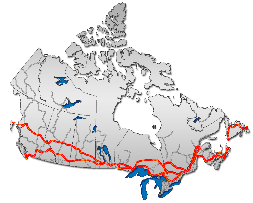
MB Highway 1Highways in Manitoba Primary Secondary Winnipeg City Routes  Portions of the Trans-Canada Highway
 British Columbia: Highway 1 • Highway 5 • Highway 16 | Alberta: Highway 1 • Highway 16
Saskatchewan: Highway 1 • Highway 16 | Manitoba: Highway 1 • Highway 16 • Highway 100
Ontario: Highway 17 • Highway 69 • Highway 400 • Highway 12 • Highway 7 • Highway 71 • Highway 11 • Highway 66 • Highway 417
Quebec: Autoroute 40 • Autoroute 25 • Autoroute 20 • Autoroute 85 • Route 185 • Route 117 • Autoroute 15
New Brunswick: Route 2 • Route 16 | Confederation Bridge | Prince Edward Island: Route 1 | Nova Scotia: Highway 104 • Highway 105 • Highway 106
Newfoundland: Route 1Categories:- Expressways in Manitoba
- Orbital roads in Canada
- Urban segments of the Trans-Canada Highway

Wikimedia Foundation. 2010.