- Manitoba Highway 6
-
Highway 6
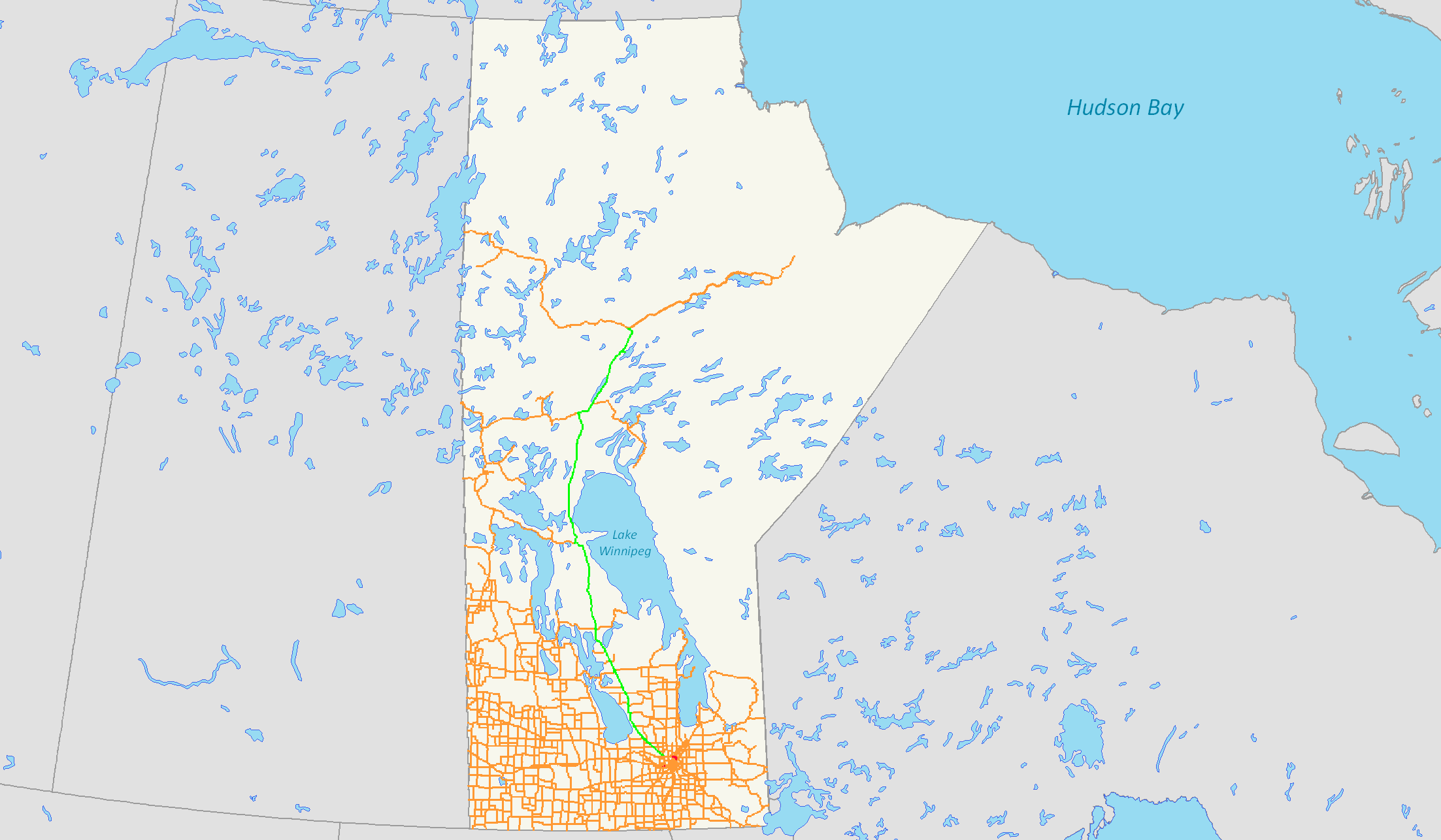
Northern Woods and Water Route (section) Route information Length: 732 km (455 mi) Major junctions South end:  PTH 101 in Winnipeg
North end: Thompson city limits
highway continues as PR 391Location Towns: Grosse Isle, Warren, Lundar, Eriksdale, Ashern, Grand Rapids Highway system ←  PTH 5
PTH 5PTH 7  →
→ Manitoba Provincial Hwy 6
Provincial Trunk Highway 6 (PTH 6) is a provincial highway in the Canadian province of Manitoba. It runs from the Thompson south city limits to the Perimeter Highway of Winnipeg. It is also the main highway connecting Winnipeg to northern Manitoba. The speed limit is 100 km/h. The route is also used to deliver nickel from the Thompson mine to the Royal Canadian Mint in Winnipeg. The portion of the highway between Ponton and Thompson was previously known as Highway 391.
There have been talks of extending PTH 6 North to Churchill and the Nunavut border. If plans to make a highway in Nunavut connecting from Churchill, and Arviat, Nunavut to Chesterfield Inlet, Nunavut go through, then the first ever major road connection to Nunavut will be made.
Connections to Winnipeg
PTH 6 only runs to the Perimeter Highway near Winnipeg, so travellers travelling to Winnipeg must take the Perimeter Highway eastbound or southbound.
Travel eastbound, then take one of these exits:
Exit (60A/B)- PTH 7/Route 90/Brookside Blvd.
Exit 69A/B- PTH 8/Route 180/McPhillips St./McPhillips Rd.
Exit (72A/B)- PTH 9/Route 52/Main St.
Or travel southbound and take:
Exit (50)- PR 221/Rosser Rd.
Exit 42A/B- PTH 1/Trans-Canada Highway/Yellowhead Highway/Route 85/Portage Ave.
- Exit numbers in brackets are unsigned and are approximate kilometre points.
- Travellers from Winnipeg do the opposite, entering Perimeter Highway, then turning at PTH 6.
Travel Route
This is the travel route for Provincial Highway 6 (PTH 6) from south to north:
km Municipality Location Interescting highway Notes 0 Rosser R.M. PTH 101 – Brandon, Portage la Prairie, Selkirk, Grand BeachPerimeter Highway
PTH 6 begins1 PR 236 north – Stonewall, Balmoral begin PR 236 west concurrence 2 PR 236 west – Rosser end PR 236 west concurrence
PTH 6 turns northwest14 Rockwood R.M. Grosse Isle PR 321 east – Stony Mountain 23 Woodlands R.M. Warren  PTH 67 east – Stonewall, Selkirk
PTH 6 turns west to bypass Warren 25 PR 227 west – Westbourne PTH 6 turns northwest 35 PR 323 east – Argyle 39 Woodlands PR 518 north – West Shoal Lake 44 PR 411 west – St. Ambroise 46 PR 248 south – Marquette, Elie 68 St. Laurent R.M. St. Laurent PR 415 east – Shoal Lakes, Teulon 91 Coldwell R.M. PR 229 east (Clarkleigh Rd.) – Inwood, Gimli 104 Lundar PR 419 – Lundar Beach, Chatfield 123 Eriksdale R.M. Eriksdale  PTH 68 east – Arborg, Riverton
PR 417 west – Scotch Baybegin PTH 68 west concurrence 134 PTH 68 west – The Narrows, Ste. Rose du Lacend PTH 68 west concurrence 162 Siglunes R.M. PR 325 west – The Narrows begin PR 325 east concurrence 164 Ashern PR 325 east – Hodgson end PR 325 east concurrence 174 Grahamdale R.M. Moosehorn PR 237 west – Watchorn Provincial Park begin PR 237 east concurrence 176 PR 237 east – Spearhill end PR 237 east concurrence 195 PR 239 west – Steep Rock 222 PTH 6 crosses the Fairford River 237 PR 513 east – Gypsumville, Dauphin River 240 PR 328 west – Homebrook, Waterhen 380 Division No. 21 (Unorganized)  PTH 60 west – The Pas
414 PTH 6 crosses the Saskatchewan River and enters Grand Rapids 415 Grand Rapids R.M. Grand Rapids 482 Division No. 22 (Unorganized) PTH 6 passes Little Limestone Lake Provincial Park Reserve 579 Ponton  PTH 39 west – Snow Lake, Cranberry Portage, Flin Flon
PTH 6 turns east 601 Dunlop PTH 6 turns northeast 610 PR 373 east – Cross Lake, Norway House 627 Wabowden Access Rd. 661 Mystery Lake PTH 6 passes Pisew Falls Provincial Park 702 PR 375 east – Paint Lake 726 North Jonas Rd. 732 Thompson City limits PTH 6 ends
highway continues as PR 391Highways in Manitoba Primary Secondary Winnipeg City Routes Categories:- Manitoba provincial highways
- Manitoba road stubs
Wikimedia Foundation. 2010.