- U.S. Route 385
-
For the former route, see U.S. Route 385 (1926).
U.S. Route 385

Route information Auxiliary route of US 85 Length: 1,206 mi (1,941 km) Existed: 1958[1] – present Major junctions South end: Big Bend National Park  I-10 at Fort Stockton, TX
 I-20 at Odessa, TX
 I-40 at Vega, TX
 I-70 at Burlington, CO
 I-76 at Julesburg, CO
 I-80 near Chappell, NE
North end:  US 85 at Deadwood, SD
Highway system United States Numbered Highways
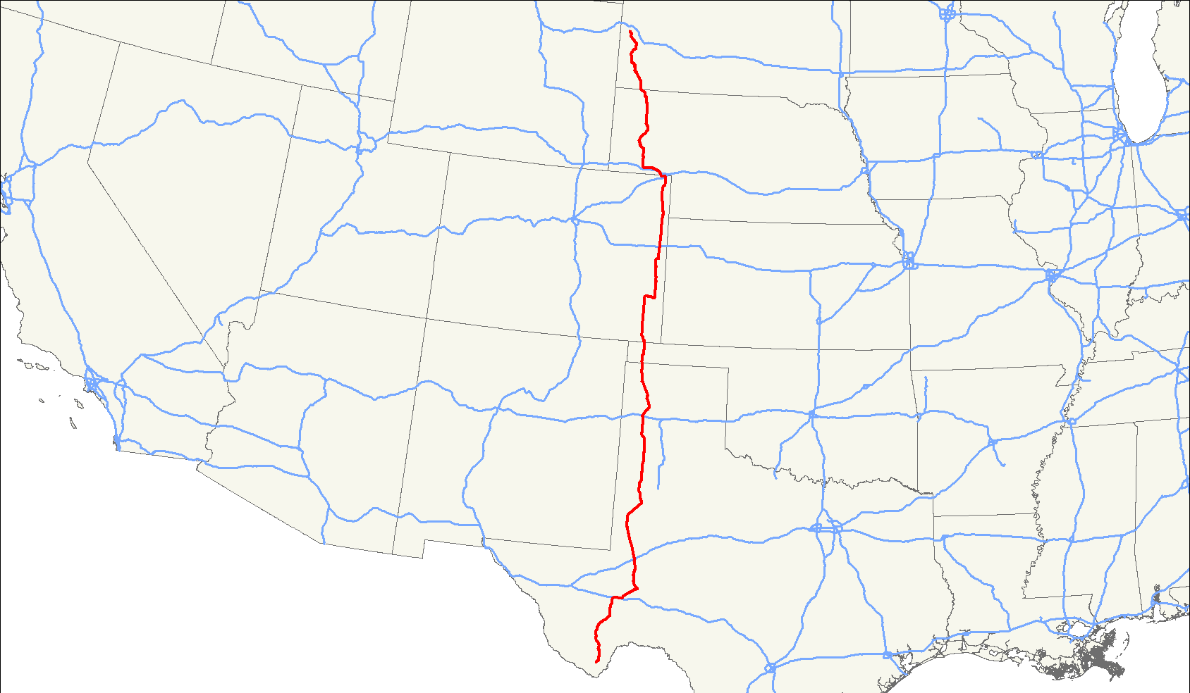
List • Bannered • Divided • ReplacedU.S. Route 385 is a spur of U.S. Route 85. It currently runs for 1,206 miles (1,941 km) from Deadwood, South Dakota to Big Bend National Park in Texas.
Contents
Route description
Lengths mi[2] km TX 545 877 OK 36 58 CO 317 510 NE 186 299 SD 122 196 Total 1206 1941 Texas
US 385 is designated as a part of the La Entrada al Pacifico trade corridor from Interstate 10 in Fort Stockton to Interstate 20 in Odessa. The section from Fort Stockton to McCamey is concurrent to US 67.

From Odessa, US 385 meets up with U.S. Highway 62 in Seminole, Texas and continues northward to Brownfield, Texas, where US 385 continues northward towards Levelland, Texas and crosses by U.S. Highway 84 in Littlefield, Texas. From Littlefield, US 385 continues northward until it crosses Interstate 40 and then goes in a half circle to Hartley, Texas where US 385 joins U.S. Highway 87. US 385 and US 87 follow a northwest track until the two meet U.S. Highway 54 and then split, with US 385 continuing northward until it exits Texas at the Oklahoma border.
On rural US 385, Speed limit is 75 mph in all counties (except Ector) going south of Gaines County starting between Seminole and Andrews down to US 90 in Marathon.
Oklahoma
In Oklahoma, US-385 runs through Cimarron County at the end of the Oklahoma panhandle. Fourteen miles north of the border, it joins with US-56, US-64, and US-412. The three highways run northeast into the county seat, Boise City. In the middle of town, the highways come to a traffic circle surrounding the Cimarron County Courthouse. The traffic circle serves seven highways (with most passing through, forming the state's only six-way concurrency): U.S. Routes 56, 64, 287, 385 and 412, and State Highways 3 and 325. Every numbered highway in the county except one meets at this traffic circle.
After leaving the circle, US-385 heads northward, overlapping US-287 and SH-3, the state's longest state highway. SH-3 ends at the state line while US-287/385 continue north into Colorado.
The section of US-385 that overlaps SH-3 is also signed as Governor George Nigh's Northwest Passage, after the governor of Oklahoma responsible for improvements to the corridor.
Colorado
U.S. 385 passes north–south through the easternmost counties of Colorado. It enters Colorado south on Campo on an overlap with U.S. Route 287. The overlap continues north until Lamar. At Lamar, the route turns east on an overlap with U.S. Route 50 and this overlap ends in Granada. The highway turns north at Granada and meets Interstate 70 at Burlington and Interstate 76 at Julesburg. The highway leaves Colorado northwest of Julesburg.
Nebraska
U.S. 385 passes north–south through the Nebraska Panhandle. It enters Nebraska south of Chappell and overlaps U.S. Route 30 between Chappell and Sidney. At Sidney, it turns north, meeting U.S. Route 26 at Bridgeport. It goes through Alliance before intersecting U.S. Route 20 at Chadron. It exits the state northwest of Chadron.
South Dakota
U.S. 385 enters South Dakota south of Oelrichs. It is overlapped with U.S. Route 18 between Oelrichs and Hot Springs It turns north and enters Wind Cave National Park before turning west to go through Pringle. At Custer, it begins an overlap with U.S. Route 16, which ends near Hill City. It gradually turns northwesterly and ends at an intersection with U.S. Route 85 at Deadwood.
Legally, the South Dakota section of U.S. 385, with the exception of concurrencies with U.S. 18 and U.S. 16 and a gap at Wind Cave National Park, is defined at South Dakota Codified Laws § 31-4-235.[3]
History
Today's U.S. Route 385 is the second route to bear the number. The original route eventually became part of U.S. 87 and the U.S. 385 designation was decommissioned around 1935.[4]
The current U.S. 385 first appeared in 1959.[5][6] Originally, the route continued along U.S. 287 north of Lamar, Colorado, splitting in Kit Carson to follow U.S. 40 east to meet up with the present-day alignment in Cheyenne Wells.[6]
References
- ^ Droz, Robert V. U.S. Highways : From US 1 to (US 830). URL accessed 22:46, 20 February 2006 (UTC).
- ^ "U.S. Route Number Database". American Association of State Highway and Transportation Officials. http://nchrp20-7-228.com/USRoute.aspx. Retrieved 2011-5-1.
- ^ South Dakota Codified Laws § 31-4-235
- ^ End of historic U.S. Highway 385 [I]
- ^ End of U.S. Highway 385
- ^ a b Colorado Routes 367-399
Browse numbered routes ←  US 380
TX I-410  →
→←  US-377
OK US-412  →
→←  SH 371
CO SH 389  →
→←  N-370
N-370NE I-480  →
→←  SD 377
SD SD 391  →
→U.S. Routes related to US 85  Categories:
- Three-digit U.S. Highways
- U.S. Highways in Nebraska
- U.S. Highways in South Dakota
- U.S. Highways in Colorado
- U.S. Highways in Oklahoma
- U.S. Highways in Texas


Wikimedia Foundation. 2010.