- Oklahoma State Highway 3
-
"OK 3" redirects here. OK 3 may also refer to Oklahoma's 3rd congressional district.
State Highway 3
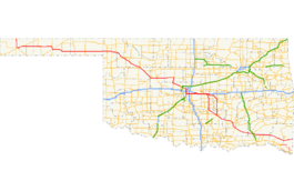
Route information Maintained by ODOT Length: 616.5 mi (992.2 km) Existed: 1939 – present Major junctions West end: Colorado state line (concurrent with US-287/385) East end:  AR-32 at the Arkansas state line
Highway system Oklahoma State Highways
Oklahoma turnpike system←  SH-2
SH-2SH-4  →
→State Highway 3, also abbreviated as SH-3 or OK-3, is a highway maintained by the U.S. state of Oklahoma. Traveling diagonally through Oklahoma, from the Panhandle to the far southeastern corner of the state, SH-3 is the longest state highway in the Oklahoma road system, at a total length of 616.5 mi[1] (992 km) via SH-3E (see below).
Contents
Route description
In the northwest
Highway 3 begins at the Colorado state line 19 mi (31 km) north of Boise City, Oklahoma. At this terminus, it is concurrent with US-287/US-385. It remains concurrent with the two U.S. Routes until reaching Boise City, where it encounters a traffic circle which contains five other highways. After the circle, US-385 splits off, and SH-3 overlaps US-287, US-56, US-64, and US-412, though US-56 and US-287 both split off within the next eight miles (13 km).
In Guymon, US-64 splits off. At Elmwood, US-270 joins US-412, coming from a concurrency with State Highway 23. SH-3 remains concurrent with US-270 through Watonga. In Seiling, US-183 leaves the concurrency but is quickly replaced by U.S. Highway 281. SH-33 joins the roadbed twenty miles (32 km) later.
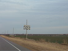 SH-3 and SH-33 concurrency between Watonga and Kingfisher.
In Watonga, SH-33 and SH-3 split off from US-270 and US-281. Highways 3 and 33 remain concurrent for 28 more miles, until Kingfisher, where SH-3 joins U.S. Highway 81. It will stay concurrent with US-81 for 13 miles (21 km), through the town of Okarche. Three miles after Okarche, SH-3 leaves US-81. This marks the first point that SH-3 has not been part of a concurrency.
Through Oklahoma City
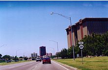
Beginning at the split from US-81, Highway 3 becomes a major artery in the Oklahoma City highway system, commonly known as the Northwest Expressway because it is a diagonal route and because it serves the northwestern part of the metro area. It skirts the northern limits of El Reno before entering the Oklahoma City limits. The often-congested Northwest Expressway passes through the suburb of Warr Acres and passes close to Lake Hefner.
At the intersection with the Lake Hefner Parkway, SH-3 again re-enters a concurrency. The Lake Hefner Parkway ends very shortly after, and SH-3 becomes concurrent with Interstate 44 through the western side of the city. Near Will Rogers World Airport, Highway 3 transfers to I-240 along the southern side of the city. After I-240 ends, SH-3 is transferred onto I-40 (also carrying US-270), which it remains concurrent with for 16 miles (26 km).
SH-3E/3W split
In Shawnee, SH-3 splits into two highways, SH-3E and SH-3W. SH-3W splits off I-40 onto U.S. Highway 177, along with US-270, at I-40 milemarker 181. It continues along with US-270 and 177 through the west side of Shawnee, and continues south of that city until Tecumseh, where US-270 splits off. South of Asher, Oklahoma, SH-3W leaves US-177 and veers southeast toward Ada.
SH-3E, the longer of the two split routes, was the original routing of Highway 3 before the two highways were split. It remains on I-40 for five miles (8 km) after SH-3W splits off. When it does split off, it soon joins SH-18. It follows a route closer to the center of Shawnee. After leaving Shawnee, it heads southeast toward Seminole. Here, it meets US-377/SH-99. SH-3E merges onto this highway, and they will remain concurrent until after they reach Ada.
In Ada, SH-3E and SH-3W are reunited and become SH-3 once again.
Ada to Atoka
SH-3 then becomes part of the Richardson Loop, a freeway around the west and south sides of Ada. Throughout the Richardson Loop, it overlaps SH-1 and US-377/SH-99 at different times. The highway then becomes two-lane once again and heads southeast to the town of Coalgate, where begins an 18-mile (29 km) concurrency with U.S. Highway 75, lasting through Atoka. In Atoka, US-75 splits off to join U.S. Highway 69.
Antlers to Arkansas
Two miles west of Antlers, the highway has an interchange with the Indian Nation Turnpike, and in Antlers it intersects U.S. Highway 271. After reaching the town of Broken Bow, Oklahoma, it turns southward and overlaps US-259 and US-70.
Near Idabel, the highway splits off after being with US-259 for 13 mi (21 km). Twenty-eight miles later, it becomes Highway 32 as it crosses the state line into Arkansas.
History
The current SH-3 was designated on 15 May 1939. The original highway included all of current SH-3 up to Antlers, where it terminated at US-271. It was extended to the Arkansas state line on 4 August 1952. SH-3 ended there concurrent with US-70 and SH-7, near DeQueen, Arkansas. On 7 January 1963, the highway was given its own alignment from near Idabel to Arkansas, taking over that of SH-21, which was eliminated at that time.
From the highway's commissioning to 1976, there was only one fork of SH-3 between Shawnee and Ada, which was the path of current SH-3E. SH-3W and SH-3E were created on 4 October 1976; the new SH-3W took over all of SH-13. Other than minor realignments, the highway remains essentially the same today.[2]
In the early 1980s, Governor George Nigh was able to obtain $97.1 million to upgrade the highway between Oklahoma City and Colorado, despite opponents labeling the project "the highway to nowhere".[3] House Concurrent Resolution 1067 labeled the highway as "Governor George Nigh's Northwest Passage." ODOT officially named the highway on 2 February 1981.[4]
Notes
- SH-3's concurrency with Interstate 44 in Oklahoma City is an example of a wrong-way concurrency - I-44 West is SH-3 East and vice-versa.
- SH-3's concurrency with US-70 is also a wrong-way concurrency, as US-70 is signed as going west and SH-3 as going east.
- The SH-3 bypass around Atoka is named the Cecil B. "Bud" Greathouse Bypass. It was designated by ODOT on 4 October 1982.[5]
SH-3A

 SH-3A
SH-3ASH-3 had one lettered spur, SH-3A, which continued the alignment of the Northwest Expressway for two more miles before ending at Interstate 44 near Penn Square Mall. It was originally known as SH-66A, a spur off U.S. Highway 66, which once ran through the area. The combined effect of US-66 being decommissioned and "3A" being a more logical name for an extension of Highway 3 led to the name change. State Highway 3A was decommissioned in 2009.
Junction list
Colorado to Shawnee
County Location Mile[1] Destinations Notes Cimarron 0.0 
 US-287/385
Colorado state line, western terminus Boise City 18.7 Boise City traffic circle (various highways) 20.5 US-28726.5  US-56
US-5634.1  SH-171
Texas Four Corners 53.0  SH-95
SH-9558.0 SH-9576.4  SH-136
Guymon 80.5  US-64
US-6481.3  US-54
US-5481.7 US-54/SH-13696.2  SH-94
SH-94Southern terminus of SH-94 Beaver Bryan's Corner 119.4  US-83
US-83Elmwood 136.3 
 US-270/SH-23
SH-23 does not concur Harper 171.5  US-283
May 179.6  SH-48
SH-48Ellis No major junctions Woodward Fort Supply 189.2  US-183
Woodward 203.0  SH-15
SH-15Eastern terminus of SH-15 205.1 
 US-412/SH-34
208.8 SH-34217.9  SH-50
SH-50Dewey 236.3 US-183Seiling 238.5 
 US-60/281
239.1  US-60/SH-51
Hucmac 247.5 US-60/SH-51Blaine 267.4 
 SH-33/58
Southern terminus of SH-58 Watonga 276.9  US-270/281/SH-8
SH-8 does not run concurrent with SH-3 Kingfisher Kingfisher 304.6  US-81/SH-33
Canadian 316.7 US-81Trumpet interchange Oklahoma City 330.4 SH-4334.0[6] Kilpatrick Turnpike Diamond interchange Oklahoma 341.3 
 SH-74/SH-3A
Diamond interchange, western terminus of SH-3A 342.9 
 I-44/SH-66/74
Stack interchange, southern terminus of SH-74, SH-66 does not concur with SH-3 346.9  I-40/US-270
349.2  SH-152
Eastern terminus of SH-152 351.4 
 I-44/240/US-62
SH-3 joins I-240 at its western terminus 355.9 
 I-35/US-62/77
I-35/US-77 do not run concurrent with SH-3 359.8  SH-77H
Northern terminus of SH-77H 368.1 I-40/240/US-270Eastern terminus of I-240 Pottawatomie McLoud 379.6  SH-102
Dale 381.3 SH-102Shawnee 384.2 
 US-177/270/SH-3W
Road separates into SH-3W and SH-3E. SH-3W leaves I-40 here while SH-3E continues along the interstate. 1.000 mi = 1.609 km; 1.000 km = 0.621 mi SH-3E
County Location Mile[1] Destinations Notes Pottawatomie Shawnee 388.3 I-40391.0  SH-18
SH-18393.0 SH-18399.0  SH-9A
SH-9A400.2  SH-99A
Western terminus of SH-99A Seminole Seminole 407.9  US-270/SH-9
SH-9 does not concur with SH-3E 410.3 
 US-270/377/SH-99
412.7  SH-59
SH-59Bowlegs 415.5 SH-59430.0 
 SH-39/SH-56
Eastern terminus of SH-39, western terminus of SH-56 Pontotoc Ada 440.8  US-377/SH-1/99
442.6  SH-3W/SH-19
SH-3E merges with SH-3W to form SH-3; interchange, eastern terminus of SH-19. 1.000 mi = 1.609 km; 1.000 km = 0.621 mi SH-3W
County Location Mile[7] Destinations Notes Pottawatomie Shawnee 388.7 

BUS US-270390.2 SH-18Southern terminus of SH-18 Tecumseh 394.6 US-270/SH-9SH-9 does not run concurrent with SH-3W Chisney 402.7  SH-59B
Eastern terminus of SH-59B Pearson 407.7 SH-59Asher 413.8 SH-39McClain 416.5 US-177/SH-59Pontotoc 422.4  SH-59A
Eastern terminus of SH-59A 433.5 SH-19Ada 434.8  SH-1/3/19
SH-3W merges with SH-3E to form SH-3; interchange, eastern terminus of SH-19. 1.000 mi = 1.609 km; 1.000 km = 0.621 mi Ada to Arkansas
- Note: mileage follows the SH-3E branch.
County Location Mile[1] Destinations Notes Pontotoc Ada 443.3 SH-1Interchange 446.5 US-377/SH-99Interchange Ahloso 448.2 US-377/SH-99Coal Tupelo 463.5 SH-48473.1  US-75
US-75Coalgate 476.8  SH-31
SH-31476.9 SH-31477.4  SH-43
SH-43Western terminus of SH-43 Atoka Atoka 490.2  US-69
US-69490.7 US-69/75Pushmataha Antlers 521.1 Indian Nation Turnpike Interchange 521.8 SH-2Southern terminus of SH-2 522.8  US-271
523.8 US-271Rattan 535.5  SH-93
SH-93Northern terminus of SH-93 Oleta 539.6  SH-147
Northern terminus of SH-147 McCurtain 567.3  SH-98
SH-98Northern terminus of SH-98 Broken Bow 578.4 
 US-70/259
Idabel 588.1 US-70/259616.5 Hwy. 32Arkansas state line, eastern terminus 1.000 mi = 1.609 km; 1.000 km = 0.621 mi References
- ^ a b c d Stuve, Eric. "OK-3". OKHighways. http://www.okhighways.com/ok3.html. Retrieved 2006-08-21.
- ^ ODOT Planning & Research Division. "Memorial Dedication & Revision History - SH-3". http://www.okladot.state.ok.us/memorial/legal/sh3.htm. Retrieved 2006-08-21.
- ^ http://www2.lsb.state.ok.us/2001-02HB/hcr1067_enr.rtf
- ^ ODOT Planning & Research Division. "Memorial Dedication & Revision History - SH-3 Northwest Expressway". http://www.okladot.state.ok.us/memorial/legal/sh3nw.htm. Retrieved 2007-05-06.
- ^ ODOT Planning & Research Division. "Memorial Dedication & Revision History - SH-3 Bypass". http://www.okladot.state.ok.us/memorial/legal/sh3bp.htm. Retrieved 2007-05-06.
- ^ Google, Inc. Google Maps – Oklahoma State Highway 3 (Map). Cartography by Google, Inc. http://maps.google.com/maps?f=d&hl=en&geocode=16418413105139565325,35.604660,-97.745290&saddr=N+Piedmont+Rd+%4035.604660,+-97.745290&daddr=35.580104,-97.688995&mra=mi&mrsp=1,0&sz=19&sll=35.579986,-97.688769&sspn=0.001261,0.002918&ie=UTF8&ll=35.608045,-97.701931&spn=0.080668,0.186768&z=13. Retrieved 2008-02-24.
- ^ Stuve, Eric. "OK-3w". OKHighways. http://www.okhighways.com/ok3w.html. Retrieved 2008-02-28.
External links
Categories:- State highways in Oklahoma
- Transportation in Oklahoma City, Oklahoma


Wikimedia Foundation. 2010.