- McClain County, Oklahoma
-
McClain County, Oklahoma 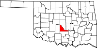
Location in the state of Oklahoma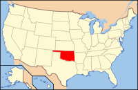
Oklahoma's location in the U.S.Founded 1907 Seat Purcell Area
- Total
- Land
- Water
580 sq mi (1,502 km²)
570 sq mi (1,476 km²)
10 sq mi (26 km²), 1.80%Population
- (2000)
- Density
27,740
21/sq mi (8/km²)Website mcclain-co-ok.us McClain County is a county located in the U.S. state of Oklahoma. The population was 27,740 at the 2000 census. Its county seat is Purcell[1]. McClain County is part of the Oklahoma City Metropolitan Statistical Area, and is in the top 3 fastest growing counties in Oklahoma with a growth rate of 21.5%
McClain County is named for Charles M. McClain, an Oklahoma constitutional convention attendee.[2]
Contents
Infrastructure
Libraries
Pioneer Library System operates branch libraries in nine cities in Cleveland, McClain and Pottawatomie counties.[3]
Major highways
The busiest highway in the county is Interstate 35, which enters the county on the north at Goldsby on the McCall Bridge. It then parallels the Canadian River through the county seat, Purcell. It eventually turns southward and leaves the county at its border with Garvin County.
Another important interstate highway is Interstate 44, which runs through the northwestern part of the county. The H.E. Bailey Turnpike Norman Spur connects this highway to the US-62/US-277/SH-9 intersection.
SH-9 enters McClain County via the McCall bridge, duplexed with I-35, and immediately turns due west, running along the northern edge of Goldsby until its intersection with U.S. Highway 62/U.S. Highway 277 south of Newcastle, Oklahoma. From this intersection the three highways, continue southwest towards Blanchard and further on to Chickasha in Grady County.
County roads
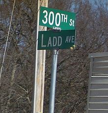 Example of McClain County road signage.
Like many counties, McClain County contains an extensive network of county-maintained roads. They form a grid with parallel roads generally placed 1 mile apart.
To dispel confusion and assist the small cities introducing new 9-1-1 systems, the county road system was recently renamed and signed throughout the county. East-west roads are numbered, with 100th St. located along the southern edge of the county, and the numbers gradually increasing toward the northern tip of the county. North-south streets are named, generally indicating the name of the road in the Oklahoma City grid that the county road best aligns with. (e.g. Santa Fe Avenue would, if extended northward, eventually connect with the street of the same name in Oklahoma City.)
Geography
According to the U.S. Census Bureau, the county, roughly triangular in shape, has a total area of 580 square miles (1,500 km2), of which 570 square miles (1,500 km2) is land and 10 square miles (26 km2) (1.80%) is water.
Adjacent counties
- Cleveland County (north)
- Pottawatomie County (northeast)
- Pontotoc County (east)
- Garvin County (south)
- Grady County (west)
Demographics
 Age pyramid for McClain County, Oklahoma, based on census 2000 data.
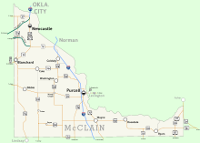 Map of McClain County
As of the census[4] of 2000, there were 27,740 people, 10,331 households, and 8,037 families residing in the county. The population density was 49 people per square mile (19/km²). There were 11,189 housing units at an average density of 20 per square mile (8/km²). The racial makeup of the county was 87.26% White, 0.66% Black or African American, 5.61% Native American, 0.22% Asian, 0.03% Pacific Islander, 2.24% from other races, and 3.98% from two or more races. 4.86% of the population were Hispanic or Latino of any race.
There were 10,331 households out of which 36.00% had children under the age of 18 living with them, 65.30% were married couples living together, 9.00% had a female householder with no husband present, and 22.20% were non-families. 19.40% of all households were made up of individuals and 8.40% had someone living alone who was 65 years of age or older. The average household size was 2.66 and the average family size was 3.04.
In the county, the population was spread out with 26.80% under the age of 18, 8.10% from 18 to 24, 29.00% from 25 to 44, 24.00% from 45 to 64, and 12.00% who were 65 years of age or older. The median age was 37 years. For every 100 females there were 98.60 males. For every 100 females age 18 and over, there were 96.10 males.
The median income for a household in the county was $37,275, and the median income for a family was $42,487. Males had a median income of $31,062 versus $21,506 for females. The per capita income for the county was $18,158. About 8.30% of families and 10.50% of the population were below the poverty line, including 13.40% of those under age 18 and 8.80% of those age 65 or over.
Cities and towns
NRHP sites
The following sites in McClain County are listed on the National Register of Historic Places:
- Hotel Love, Purcell
- McClain County Courthouse, Purcell
- James C. Nance Memorial Bridge (U.S. Highway 77/State Highway 39 Bridge over the Canadian River), Purcell/Lexington
References
- ^ "Find a County". National Association of Counties. http://www.naco.org/Counties/Pages/FindACounty.aspx. Retrieved 2011-06-07.
- ^ Oklahoma Historical Society. "McCLAIN COUNTY", Encyclopedia of Oklahoma History and Culture (retrieved April 2, 2011).
- ^ "Pioneer Library System to buy Borders bookstore building in Norman". NewsOK. The Oklahoman. September 27, 2011. http://newsok.com/article/3608103. Retrieved 2011-10-25.
- ^ "American FactFinder". United States Census Bureau. http://factfinder.census.gov. Retrieved 2008-01-31.
Municipalities and communities of McClain County, Oklahoma Cities 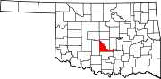
Towns Unincorporated
communitiesCriner | Payne | Stealy | Woody Chapel
Footnotes ‡This populated place also has portions in an adjacent county or counties
Municipalities of the Greater Oklahoma City Metropolitan Area Population over 500,000 Population over 100,000 Population over 50,000 Population over 20,000 Population over 10,000 Population over 5,000 Population over 2,000 Bethel Acres • Chandler • Harrah • Jones • Lexington • McLoud • Nichols Hills • Nicoma Park • Prague • Slaughterville • Spencer • StroudPopulation over 1,000 Crescent • Forest Park • Goldsby • Langston • Luther • Maud • Minco • Ninnekah • Okarche • Pink • Rush Springs • Union CityPopulation over 500 Population over 200 Population under 200 Bradley • Bridge Creek • Brooksville • Cimarron City • Etowah • Fallis • Kendrick • Lake Aluma • Macomb • Meridian • Norge • Rosedale • Smith Village • Sparks • Woodlawn ParkUnincorporated areas Regional Government Association of Central Oklahoma GovernmentsCategories:- Oklahoma counties
- Oklahoma City Metropolitan Area
- McClain County, Oklahoma


Wikimedia Foundation. 2010.