- Geography of Oklahoma
-
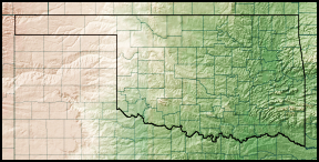
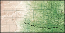 Oklahoma topographical map
The Geography of Oklahoma encompasses terrain and ecosystems ranging from arid plains to subtropical forests and mountains. Oklahoma contains 11 distinct ecological regions, more per square mile than in any other state by a wide margin.[1] One of six states on the Frontier Strip, it is situated in the Great Plains and U.S. Interior Highlands region near the geographical center of the 48 contiguous states. Usually considered part of the South Central United States, Oklahoma is bounded on the east by Arkansas and Missouri, on the north by Kansas, on the northwest by Colorado, on the far west by New Mexico, and on the south and near-west by Texas.
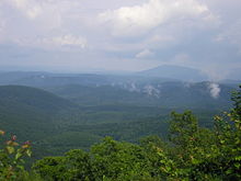
The state has four primary mountain ranges: the Arbuckle Mountains, the Wichita Mountains, the Ozark Mountains and the Ouachita Mountains.[2] Part of the U.S. Interior Highlands region, the Ozarks and Ouachitas form the only major highland region between the Rocky Mountains and the Appalachians.[3]
A portion of the Flint Hills stretches into north-central Oklahoma, and in the state's southeastern corner, Cavanal Hill is officially regarded as the world's tallest hill; at 1,999 feet (609 m), it fails the definition of a mountain by one foot.[4] More than 500 named creeks and rivers make up Oklahoma's waterways, and with 200 lakes created by dams, it holds the highest number of reservoirs in the nation.[4] Oklahoma covers an area of 69,898 square miles (181,030 km2), with 68,667 square miles (177,850 km2) of land and 1,231 square miles (3,190 km2) of water, making it the 20th-largest state in the United States.[5] Generally, it is divided into six geographical regions: Green Country, or Northeast Oklahoma, Southeastern Oklahoma, Central Oklahoma, South Central Oklahoma, Southwest Oklahoma, and Northwest Oklahoma.
Contents
Topography
 See also: Lakes in Oklahoma
Situated between the Great Plains and the Ozark Plateau in the Gulf of Mexico watershed,[6] Oklahoma tends to slope gradually downward from its western to eastern boundaries.[2][7] Its highest and lowest points follow this trend, with its highest peak, Black Mesa, at 4368 feet (1,516 m) above sea level, situated near the far northwest corner of the Oklahoma Panhandle. The state's lowest point is on the Little River near its far southeastern boundary, which dips to 289 feet (88 m) above sea level.[8]
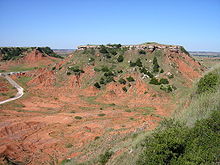
Most of the state lies in two primary drainage basins belonging to the Red and Arkansas rivers, though the Lee and Little rivers also contain significant drainage basins.[9] In the state’s northwestern corner, semi-arid high plains harbor few natural forests and rolling to flat landscape with intermittent canyons and mesa ranges like the Glass Mountains. Partial plains interrupted by small mountain ranges like the Antelope Hills and the Wichita Mountains dot southwestern Oklahoma, and transitional prairie and woodlands cover the central portion of the state. The Ozark and Ouachita Mountains rise from west to east over the state's eastern third, gradually increasing in elevation in an eastward direction.[7][9]
Flora and fauna
Forests cover 24 percent of Oklahoma,[4] and prairie grasslands, composed of shortgrass, mixed-grass, and tallgrass prairie, harbor expansive ecosystems in the state's central and western portions. Where rainfall is sparse in the western regions of the state, shortgrass prairie and shrublands are the most prominent ecosystems, though pinyon pines, junipers, and ponderosa pines grow near rivers and creek beds in the far western reaches of the panhandle.[10] Marshlands, cypress forests and mixtures of shortleaf pine, loblolly pine and deciduous forests dominate the state's southeastern quarter, while mixtures of largely post oak, elm, cedar and pine forests cover the Ozark Mountains in northeastern Oklahoma.[9][10][11]
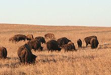
The state holds large populations of white-tailed deer, coyotes, bobcats, elk, and birds such as quail, doves, cardinals, bald eagles, red-tailed hawks, and pheasants. In prairie ecosystems, american bison, greater prairie-chickens, badgers, and armadillo are common, and some of the nation's largest prairie dog towns inhabit shortgrass prairie in the state's panhandle. The Cross Timbers, a region transitioning from prairie to woodlands in Central Oklahoma, harbors 351 vertebrate species. The Ouachita Mountains are home to black bear, red fox, grey fox, and river otter populations, which coexist with a total of 328 vertebrate species in southeastern Oklahoma.[10]
Protected lands
Oklahoma has 50 state parks,[12] six national parks or protected regions,[13] two national protected forests or grasslands,[14] and a network of wildlife preserves and conservation areas. Six percent of the state's 10 million acres (40,000 km²) of forest is public land,[11] including the western portions of the Ouachita National Forest, the largest and oldest national forest in the southern United States.[15] With 39,000 acres (160 km2), the Tallgrass Prairie Preserve in north-central Oklahoma is the largest protected area of tallgrass prairie in the world and is part of an ecosystem that encompasses only 10 percent of its former land area, once covering 14 states.[16] In addition, the Black Kettle National Grassland covers 31,300 acres (127 km2) of prairie in southwestern Oklahoma.[17] The Wichita Mountains Wildlife Refuge is the oldest and largest of nine national wildlife refuges in the state[18] and was founded in 1901, encompassing 59,020 acres (238.8 km2).[19] Of Oklahoma's federally protected park or recreational sites, the Chickasaw National Recreation Area is the largest, with 4,500 acres (18 km2).[20] Other federal protected sites include the Santa Fe and Trail of Tears national historic trails, the Fort Smith and Washita Battlefield national historic sites, and the Oklahoma City National Memorial.[13]
Climate
Oklahoma is situated in a temperate continental climate between regions of differing prevailing winds, making its weather widely different between relatively short distances. Much of the state is often subjected to extremes in temperature, wind, drought, and rainfall.[21] Most of the state lies in an area known as Tornado Alley characterized by frequent interaction between cold and warm air masses producing severe weather.[8] An average 54 tornadoes strike the state per year—one of the highest rates in the world.[22] Because of its position between zones of differing prevailing temperature and winds, weather patterns within the state can vary widely between relatively short distances.[8]
 Hickory, pine, and oak forests dominate Northeastern Oklahoma, which receives far more rain than western areas of the state.
Eastern Oklahoma has a humid subtropical climate (Koppen Cfa) heavily influenced by southerly winds bringing moisture from the Gulf of Mexico and provides hot, humid summers and generally mild winters with cold spells. This transitions progressively to a semi-arid zone (Koppen BSk) in the high plains of the Panhandle, where a drier climate prevails with somewhat colder winters and similarly hot summers but much lower humidity. Other western areas of the state, including Lawton and Enid in the transition zone, are also less touched by southern moisture and tend to be drier.[21] Precipitation and temperatures fall from east to west accordingly, with areas in the southeast averaging an annual temperature of 62 °F (17 °C) and an annual rainfall of 56 inches (1,420 mm), while areas of the panhandle average 58 °F (14 °C), with an annual rainfall under 17 inches (430 mm).[8] All of the state frequently experiences temperatures above 100 °F (38 °C) or below 0 °F (−18 °C),[21] and snowfall ranges from an average of less than 4 inches (10 cm) in the south to just over 20 inches (51 cm) on the border of Colorado in the panhandle.[8] The state is home to the National Storm Prediction Center of the National Weather Service located at Norman.[23]
References
- ^ "Oklahoma, All Terrain Vacation". TravelOK. TravelOK.com. 2006-01-12. http://www.travelok.com/atv/index.asp. Retrieved 2006-07-15.
- ^ a b "The Geography of Oklahoma". Netstate. 2007-07-31. http://www.netstate.com/states/geography/ok_geography.htm. Retrieved 2007-07-31.
- ^ "Managing Upland Forests of the Midsouth". USDA Forest Service. 2007-03-07. http://www.srs.fs.usda.gov/4159/about/HotSpringsOffice.htm. Retrieved 2007-07-31.
- ^ a b c "About Oklahoma". TravelOK.com. 2007. http://www.travelok.com/about/index.asp. Retrieved 2006-07-10.
- ^ "Land and Water Area of States, 2000". Information Please. 2000. http://www.infoplease.com/ipa/A0108355.html. Retrieved 2006-11-22.
- ^ "A Tapestry of Time and Terrain". USGS. 2003-04-17. http://tapestry.usgs.gov/physiogr/physio.html. Retrieved 2007-07-31.
- ^ a b "Oklahoma State Map Collection". geology.com. 2006. http://geology.com/state-map/oklahoma.shtml. Retrieved 2007-08-01.
- ^ a b c d e Arndt, Derek (2003-01-01). "The Climate of Oklahoma". Oklahoma Climatological Survey. http://cig.mesonet.org/climateatlas/doc60.html. Retrieved 2007-07-31.
- ^ a b c "Oklahoma in Brief" (pdf). State of Oklahoma. 2003. http://www.odl.state.ok.us/almanac/2005/3-inbrief.pdf. Retrieved 2007-08-04.
- ^ a b c "A Look at Oklahoma: A Student's Guide" (pdf). State of Oklahoma. 2005. http://www.travelok.com/about/StudentGuide.pdf. Retrieved 2007-08-14.
- ^ a b "Oklahoma Ecoregional Maps". Oklahoma Department of Agriculture. Archived from the original on 2007-10-13. http://web.archive.org/web/20071013192154/http://ok.gov/~okag/forestry-okforestshome.htm. Retrieved 2007-08-02.
- ^ "Oklahoma State Parks". Oklahoma Parks Department. 2004. http://www.oklahomaparks.com/index.asp. Retrieved 2007-08-02.
- ^ a b "Oklahoma National Park Guide". National Park Service. 2007. http://home.nps.gov/applications/parksearch/state.cfm?st=ok. Retrieved 2007-08-02.
- ^ "National Forests". United States Department of Agriculture Forest Service. 2005-05-01. http://www.fs.fed.us/recreation/map/state_list.shtml#Oklahoma. Retrieved 2007-08-02.
- ^ "Ouachita National Forest". United States Department of Agriculture Forest Service. 2005-05-10. http://www.fs.fed.us/r8/ouachita/about/. Retrieved 2007-08-02.
- ^ "Tallgrass Prairie Preserve". The Nature Conservatory. 2007. http://www.nature.org/wherewework/northamerica/states/oklahoma/preserves/tallgrass.html. Retrieved 2007-07-31.
- ^ "Black Kettle National Grassland". USDA Forest Service. 2007-07-24. http://www.fs.fed.us/r3/cibola/districts/black.shtml. Retrieved 2007-08-02.
- ^ "Refuge Locator Map - Oklahoma". U.S. Fish and Wildlife Service. http://www.fws.gov/refuges/refugeLocatorMaps/Oklahoma.html. Retrieved 2007-08-17.
- ^ "Wichita Mountains Wildlife Refuge". U.S. Fish and Wildlife Service. http://www.fws.gov/refuges/profiles/index.cfm?id=21670. Retrieved 2007-08-17.
- ^ "Chickasaw National Recreation Area". Oklahoma Wildlife Department. http://www.wildlifedepartment.com/chickasaw.htm. Retrieved 2007-08-02.
- ^ a b c "Oklahoma's Climate: an Overview" (pdf). University of Oklahoma. http://climate.mesonet.org/county_climate/Products/oklahoma_climate_overview.pdf. Retrieved 2007-08-01.
- ^ "Tornado Climatology". NOAA National Climatic Data Center. http://www.ncdc.noaa.gov/oa/climate/severeweather/tornadoes.html. Retrieved 2006-10-24.
- ^ Novy, Chris. "SPC and its Products". NOAA. http://www.spc.noaa.gov/misc/about.html. Retrieved 2007-08-01.
Geography of the United States by political division States - Alabama
- Alaska
- Arizona
- Arkansas
- California
- Colorado
- Connecticut
- Delaware
- Florida
- Georgia
- Hawaii
- Idaho
- Illinois
- Indiana
- Iowa
- Kansas
- Kentucky
- Louisiana
- Maine
- Maryland
- Massachusetts
- Michigan
- Minnesota
- Mississippi
- Missouri
- Montana
- Nebraska
- Nevada
- New Hampshire
- New Jersey
- New Mexico
- New York
- North Carolina
- North Dakota
- Ohio
- Oklahoma
- Oregon
- Pennsylvania
- Rhode Island
- South Carolina
- South Dakota
- Tennessee
- Texas
- Utah
- Vermont
- Virginia
- Washington
- West Virginia
- Wisconsin
- Wyoming
Federal district Insular areas - American Samoa
- Guam
- Northern Mariana Islands
- Puerto Rico
- U.S. Virgin Islands
Outlying islands - Bajo Nuevo Bank
- Baker Island
- Howland Island
- Jarvis Island
- Johnston Atoll
- Kingman Reef
- Midway Atoll
- Navassa Island
- Palmyra Atoll
- Serranilla Bank
- Wake Island
Categories:


Wikimedia Foundation. 2010.