- Geography of the United States Virgin Islands
-

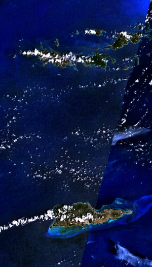 U.S. Virgin Islands - NASA NLT Landsat 7 (Visible Color) Satellite Image
Location: Caribbean, islands 1,100 miles (1,770 km) southeast of Florida, 600 miles (966 km) north of Venezuela, 40 miles (64 km) east of Puerto Rico; between the Caribbean Sea and the North Atlantic Ocean, bordering the Virgin Islands Trough and the Anegada Passage and roughly 100 miles (161 km) south of the Puerto Rico Trench
Statistics
Geographic coordinates: 18°20′N 64°50′W / 18.333°N 64.833°W
Map references: Central America and the Caribbean
Islands: Saint Croix, Saint Thomas, Saint John, Water Island, many other islands
Area:
- total: 1,910 km²
- land: 346 km²
- water: 1,564 km²
Area - comparative: twice the size of Washington, D.C.
Land boundaries: 0 km fucc Coastline: 188 km
Maritime claims:
- exclusive economic zone: 200 nmi (370.4 km; 230.2 mi)
- territorial sea: 12 nmi (22.2 km; 13.8 mi)
Terrain: Most of the islands, including Saint Thomas and Saint John, are volcanic in origin and are mostly hilly to rugged and mountainous with little level land. Saint Croix was formed by a coral reef and is flatter.
Elevation extremes:
- lowest point: Caribbean Sea 0 m
- highest point: Crown Mountain (Saint Thomas) 474 m
Natural resources: sun, sand, sea, surf
Land use:
- arable land: 5.71%
- permanent crops: 2.86%
- other: 91.43% (2005)
Irrigated land: NA km²
Natural hazards: several hurricanes in recent years; frequent and severe droughts and floods; occasional earthquakes; rare tsunamis
Environment - current issues: lack of natural freshwater resources
Geography - note: important location along the Anegada Passage - a key shipping lane for the Panama Canal; Charlotte Amalie, Saint Thomas is one of the best natural, deepwater harbors in the Caribbean; well-known beaches include Magens Bay (Saint Thomas) and Trunk Bay (Saint John); coral reefs include Virgin Islands Coral Reef National Monument and the Buck Island Reef National Monument; more than half of Saint John and nearly all of Hassel Island are owned by the U.S. National Park Service
Climate
Tropical, tempered by easterly trade winds, relatively low humidity, little seasonal temperature variation; rainy season May to November.
The U.S. Virgin Islands enjoy an arid climate, moderated by trade winds. Temperatures vary little throughout the year. In the capital, Charlotte Amalie, typical daily maximum temperatures are around 91 °F (32.8 °C) in the summer and 86 °F (30 °C) in the winter. Typical daily minimum temperatures are around 78 °F (25.6 °C) in the summer and 72 °F (22.2 °C) in the winter. Rainfall averages about 38 inches (965 mm) per year. Rainfall can be quite variable, but the wettest months on average are September to November and the driest months on average are February and March.
The islands are subject to tropical storms and hurricanes, with the hurricane season running from June to November. In recent history, substantial damage was caused by Hurricane Hugo in 1989 and Hurricane Marilyn in 1995. The islands were also struck by Hurricane Bertha in 1996, Hurricane Georges in 1998, Hurricane Lenny in 1999, Tropical Storm Jeanne in 2004, Hurricane Omar in 2008, Hurricane Earl in 2010, and Tropical Storm Otto in 2010, but damage was less severe in those storms.[1]
Climate data for Saint Thomas, VI Month Jan Feb Mar Apr May Jun Jul Aug Sep Oct Nov Dec Year Record high °F (°C) 93
(34)93
(34)94
(34)96
(36)97
(36)99
(37)98
(37)99
(37)98
(37)97
(36)95
(35)92
(33)99
(37)Average high °F (°C) 86
(30)86
(30)86
(30)88
(31)88
(31)90
(32)90
(32)91
(33)90
(32)90
(32)88
(31)86
(30)88 Average low °F (°C) 72
(22)72
(22)72
(22)74
(23)76
(24)77
(25)78
(26)78
(26)77
(25)76
(24)75
(24)73
(23)75 Record low °F (°C) 63
(17)52
(11)56
(13)62
(17)66
(19)67
(19)57
(14)59
(15)64
(18)66
(19)52
(11)62
(17)52
(11)Precipitation inches (mm) 1.89
(48)1.51
(38.4)1.52
(38.6)2.39
(60.7)3.36
(85.3)2.35
(59.7)2.42
(61.5)3.50
(88.9)5.34
(135.6)5.57
(141.5)5.28
(134.1)2.74
(69.6)37.8
(960)Source: weather.com [2] References
- ^ "Fema: US Virgin Islands State Disaster History". fema.gov. http://www.fema.gov/news/disasters_state.fema?id=78. Retrieved 21 November 2010.
- ^ "Average Conditions Saint Thomas, VI". weather.com. http://www.weather.com/outlook/travel/businesstraveler/wxclimatology/monthly/00801. Retrieved May 16, 2010.
 Territory of United States Virgin Islands
Charlotte Amalie (capital) Topics Geography | Economy | Demographics | Communications | Transportation | History | Visitor Attractions
Government Politics | Governors | Congressional Delegates | Senators | Elections
Cities Islands Parks Geography of the United States by political division States - Alabama
- Alaska
- Arizona
- Arkansas
- California
- Colorado
- Connecticut
- Delaware
- Florida
- Georgia
- Hawaii
- Idaho
- Illinois
- Indiana
- Iowa
- Kansas
- Kentucky
- Louisiana
- Maine
- Maryland
- Massachusetts
- Michigan
- Minnesota
- Mississippi
- Missouri
- Montana
- Nebraska
- Nevada
- New Hampshire
- New Jersey
- New Mexico
- New York
- North Carolina
- North Dakota
- Ohio
- Oklahoma
- Oregon
- Pennsylvania
- Rhode Island
- South Carolina
- South Dakota
- Tennessee
- Texas
- Utah
- Vermont
- Virginia
- Washington
- West Virginia
- Wisconsin
- Wyoming
Federal district Insular areas - American Samoa
- Guam
- Northern Mariana Islands
- Puerto Rico
- U.S. Virgin Islands
Outlying islands - Bajo Nuevo Bank
- Baker Island
- Howland Island
- Jarvis Island
- Johnston Atoll
- Kingman Reef
- Midway Atoll
- Navassa Island
- Palmyra Atoll
- Serranilla Bank
- Wake Island
Sovereign states Antigua and Barbuda · Bahamas · Barbados · Belize · Canada · Costa Rica · Cuba · Dominica · Dominican Republic · El Salvador · Grenada · Guatemala · Haiti · Honduras · Jamaica · Mexico · Nicaragua · Panama · Saint Kitts and Nevis · Saint Lucia · Saint Vincent and the Grenadines · Trinidad and Tobago · United States
Dependencies and
other territoriesAnguilla · Aruba · Bermuda · Bonaire · British Virgin Islands · Cayman Islands · Curaçao · Greenland · Guadeloupe · Martinique · Montserrat · Navassa Island · Puerto Rico · Saint Barthélemy · Saint Martin · Saint Pierre and Miquelon · Saba · Sint Eustatius · Sint Maarten · Turks and Caicos Islands · United States Virgin Islands
Climate of North America Sovereign states Antigua and Barbuda · Bahamas · Barbados · Belize · Canada · Costa Rica · Cuba · Dominica · Dominican Republic · El Salvador · Grenada · Guatemala · Haiti · Honduras · Jamaica · Mexico · Nicaragua · Panama · Saint Kitts and Nevis · Saint Lucia · Saint Vincent and the Grenadines · Trinidad and Tobago · United States
Dependencies and
other territoriesAnguilla · Aruba · Bermuda · Bonaire · British Virgin Islands · Cayman Islands · Curaçao · Greenland · Guadeloupe · Martinique · Montserrat · Puerto Rico · Saint Barthélemy · Saint Martin · Saint Pierre and Miquelon · Saba · Sint Eustatius · Sint Maarten · Turks and Caicos Islands · United States Virgin Islands
Categories:- Geography of the United States Virgin Islands
- Geography of the Lesser Antilles

Wikimedia Foundation. 2010.