- Geography of Nicaragua
-
Geography of Nicaragua 
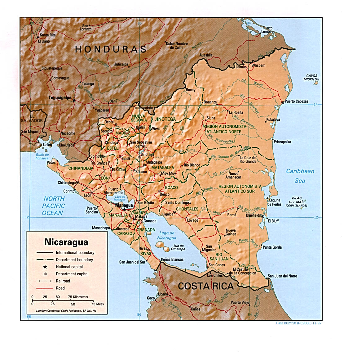
Map of Nicaragua Area Total 129,494 km2 Land 120,254 km2 Water 9,240 km2 Latitude 13 00' N Longitude 85 00'W Borders Honduras 922 km Costa Rica 309 km Coastlines 910 km Maritime claims Contiguous zone 24 nautical miles (44.4 km; 27.6 mi) Territorial sea 12 nautical miles (22.2 km; 13.8 mi)  Shaded relief map of Nicaragua
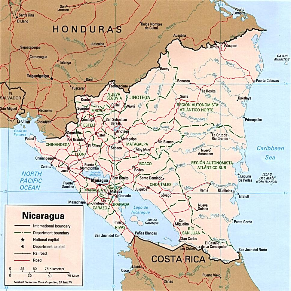
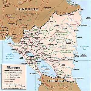 Political map of Nicaragua
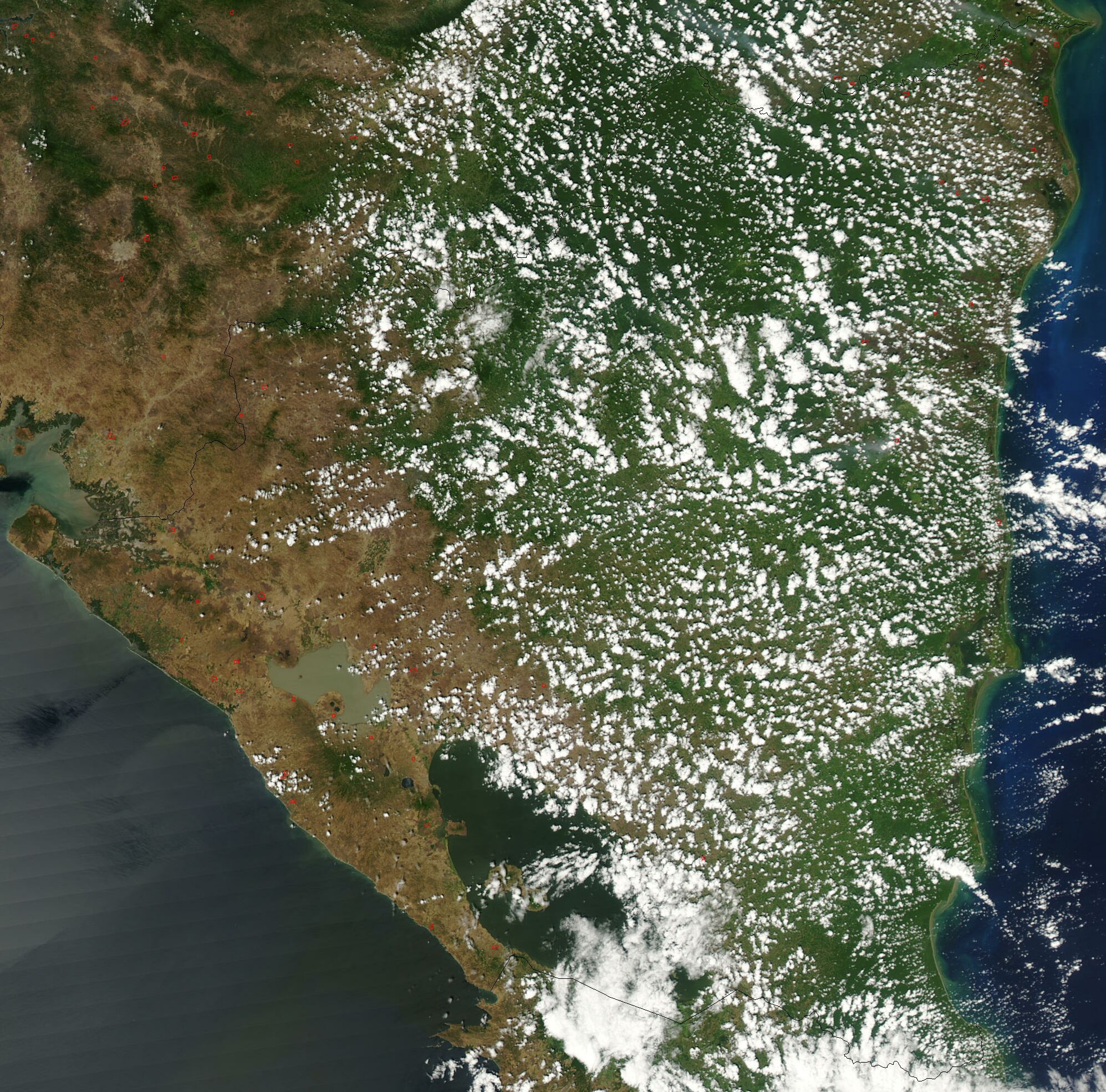
 Satellite image of Nicaragua in March 2003
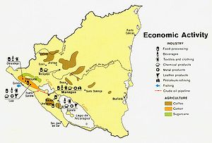 Economic activity map of Nicaragua, 1979
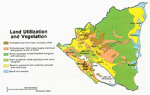 Land use map of Nicaragua, 1979
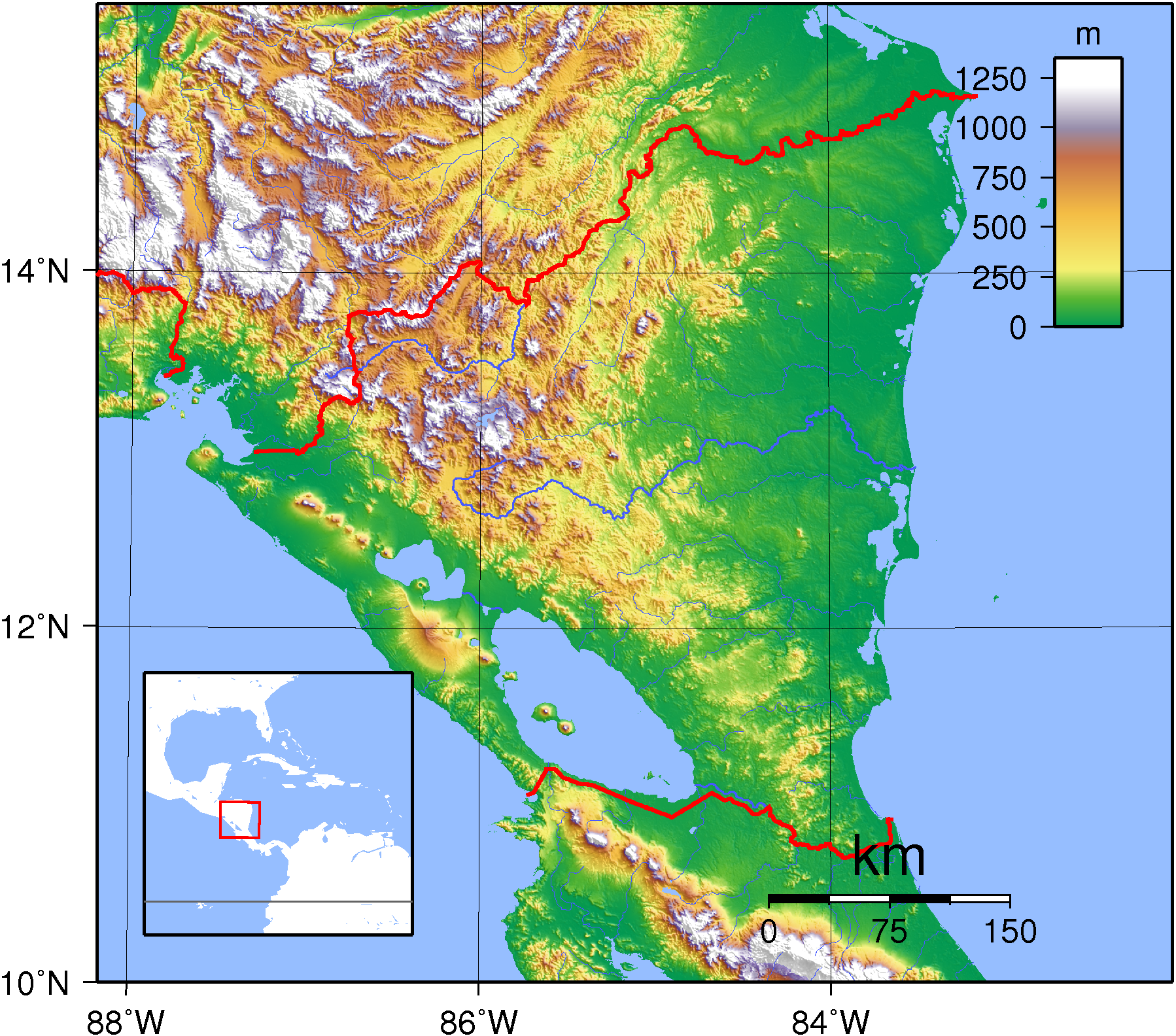
 Topography of Nicaragua
Nicaragua is a country in Central America, bordering both the Caribbean Sea and the North Pacific Ocean, between Costa Rica and Honduras. Approximately the size of Greece or the U.S. state of New York, it is the largest country in Central America. The country covers a total area of 129,494 square kilometers (120,254 square kilometers of which are land area) and contains a diversity of climates and terrains. The country's physical geography divides it into three major zones: Pacific lowlands, the wetter, cooler central highlands, and the Caribbean lowlands.
Geographic coordinates: 13°00′N 85°00′W / 13°N 85°W
Contents
Natural regions
Pacific lowlands
The Pacific lowlands extend about 75 kilometers inland from the Pacific coast. Most of the area is flat, except for a line of young volcanoes, many of which are still active, running between the Golfo de Fonseca and Lago de Nicaragua. These peaks lie just west of a large crustal fracture or structural rift that forms a long, narrow depression passing southeast across the isthmus from the Golfo de Fonseca to the Río San Juan. The rift is occupied in part by the largest freshwater lakes in Central America: Lago de Managua (56 kilometers long and 24 kilometers wide) and Lago de Nicaragua (about 160 kilometers long and 75 kilometers wide). These two lakes are joined by the Río Tipitapa, which flows south into Lago de Nicaragua. Lago de Nicaragua in turn drains into the Río San Juan (the boundary between Nicaragua and Costa Rica), which flows through the southern part of the rift lowlands to the Caribbean Sea. The valley of the Río San Juan forms a natural passageway close to sea level across the Nicaraguan isthmus from the Caribbean Sea to Lago de Nicaragua and the rift. From the southwest edge of Lago de Nicaragua, it is only nineteen kilometers to the Pacific Ocean. This route was considered as a possible alternative to the Panama Canal at various times in the past.
Surrounding the lakes and extending northwest of them along the rift valley to the Golfo de Fonseca are fertile lowland plains highly enriched with volcanic ash from nearby volcanoes. These lowlands are densely populated and well cultivated. More directly west of the lake region is a narrow line of ash-covered hills and volcanoes that separate the lakes from the Pacific Ocean. This line is highest in the central portion near León and Managua.
Because Western Nicaragua is located where two major tectonic plates collide, it is subject to earthquakes and volcanic eruptions. Although periodic volcanic eruptions have caused agricultural damage from fumes and ash, earthquakes have been by far more destructive to life and property. Hundreds of shocks occur each year, some of which cause severe damage. The capital city of Managua was virtually destroyed in 1931 and again in 1972.
Central highlands
The triangular area known as the central highlands lies northeast and east of the Pacific lowlands. This rugged mountains is composed of ridges 900 to 1,800 meters high and a mixed forest of oak and pine alternating with deep valleys that drain primarily toward the Caribbean. Very few significant streams flow west to the Pacific Ocean; those that do are steep, short, and flow intermittently. The relatively dry western slopes of the central highlands, protected by the ridges of the highlands from the moist winds of the Caribbean, have drawn farmers from the Pacific region since colonial times and are now well settled. The eastern slopes
Caribbean lowland
The eastern Caribbean lowlands of Nicaragua form the extensive (occupying more than 50 percent of national territory) and still sparsely settled lowland area known as the Costa de Mosquitos (Miskito Coast). The Caribbean lowlands are sometimes considered synonymous with the former department of Zelaya, which is now divided into the North Atlantic Autonomous Region (Región Autonomista Atlántico Norte, RAAN) and the South Atlantic Autonomous Region (Región Autonomista Atlántico Sur, RAAS) and constitutes about 45 percent of Nicaragua's territory. These lowlands are a hot, humid area that includes coastal plains, the eastern spurs of the central highlands, and the lower portion of the Río San Juan basin. The soil is generally leached and infertile. Pine and palm savannas predominate as far south as the Laguna de Perlas. Tropical rain forests are characteristic from the Laguna de Perlas to the Río San Juan, in the interior west of the savannas, and along rivers through the savannas. Fertile soils are found only along the natural levees and narrow floodplains of the numerous rivers, including the Escondido, the Río Grande de Matagalpa, the Prinzapolka, and the Coco, and along the many lesser streams that rise in the central highlands and cross the region en route to the complex of shallow bays, lagoons, and salt marshes of the Caribbean coast.
Climates
Temperature varies little with the seasons in Nicaragua and is largely a function of elevation.The"hot land," is characteristic of the foothills and lowlands from sea level to about 750 meters (2,461 ft) of elevation.And night temperatures drop to 21 to 24 °C (69.8 to 75.2 °F) most of the year. The tierra templada, or the "temperate land," is characteristic of most of the central highlands, where elevations range between 750 and 1,600 meters (2,461 and 5,249 ft).The "cold land," at elevations above 1,600 meters (5,249 ft), is found only on and near the highest peaks of the central highlands. Daytime averages in this region are 22 to 24 °C (71.6 to 75.2 °F), with nighttime lows below 15 °C (59 °F).
Rainfall varies greatly in Nicaragua. The Caribbean lowlands are the wettest section of Central America, receiving between 2,500 and 6,500 millimeters (98.4 and 255.9 in) of rain annually. The western slopes of the central highlands and the Pacific lowlands receive considerably less annual rainfall, being protected from moisture-laden Caribbean trade winds by the peaks of the central highlands. Mean annual precipitation for the rift valley and western slopes of the highlands ranges from 1,000 to 1,500 millimeters (39.4 to 59.1 in). Rainfall is seasonal—May through October is the rainy season, and December through April is the driest period.
During the rainy season, Eastern Nicaragua is subject to heavy flooding along the upper and middle reaches of all major rivers. Near the coast, where river courses widen and river banks and natural levees are low, floodwaters spill over onto the floodplains until large sections of the lowlands become continuous sheets of water. River bank agricultural plots are often heavily damaged, and considerable numbers of savanna animals die during these floods. The coast is also subject to destructive tropical storms and hurricanes, particularly from July through October. The high winds and floods accompanying these storms often cause considerable destruction of property. In addition, heavy rains (called papagayo storms) accompanying the passage of a cold front or a low-pressure area may sweep from the north through both eastern and western Nicaragua (particularly the rift valley) from November through March. Hurricanes or heavy rains in the central highlands, where agriculture has destroyed much of the natural vegetation, also cause considerable crop damage and soil erosion. In 1988 Hurricane Joan forced hundreds of thousands of Nicaraguans to flee their homes and caused more than US$1 billion in damage, most of it along the Caribbean coast.
Antipodes
Although nowhere in Central America is antipodal to another land mass, Nicaragua comes closest, with its Big Corn Island within half a kilometer of being antipodal to the South Island of the Australian Cocos (Keeling) Islands in the Indian Ocean.
Statistics
Area:
total: 129,494 km2
land: 120,254 km2
water: 9,240 km2Elevation extremes:
lowest point: Pacific Ocean 0 m
highest point: Mogotón 2,107 mLand use:
arable land: 9%
permanent crops: 1%
permanent pastures: 46%
forests and woodland: 27%
other: 17% (1993 est.)Irrigated land: 880 km2 (1993 est.)
Environment
Nicaragua is subject to destructive earthquakes, volcanoes, landslides, and occasionally severe hurricanes. It currently faces deforestation, soil erosion, and water pollution. It is a party to the United Nations Framework Convention on Climate Change, the Climate Change-Kyoto Protocol, the Nuclear Test Ban, and the Ozone Layer Protection, and has signed but not ratified the Law of the Sea.
References
 This article incorporates public domain material from websites or documents of the Library of Congress Country Studies.
- This article incorporates public domain material from websites or documents of the CIA World Factbook.
External links
Sovereign states Dependencies and
other territories- Anguilla
- Aruba
- Bermuda
- Bonaire
- British Virgin Islands
- Cayman Islands
- Curaçao
- Greenland
- Guadeloupe
- Martinique
- Montserrat
- Navassa Island
- Puerto Rico
- Saint Barthélemy
- Saint Martin
- Saint Pierre and Miquelon
- Saba
- Sint Eustatius
- Sint Maarten
- Turks and Caicos Islands
- United States Virgin Islands
Climate of North America Sovereign states - Antigua and Barbuda
- Bahamas
- Barbados
- Belize
- Canada
- Costa Rica
- Cuba
- Dominica
- Dominican Republic
- El Salvador
- Grenada
- Guatemala
- Haiti
- Honduras
- Jamaica
- Mexico
- Nicaragua
- Panama
- Saint Kitts and Nevis
- Saint Lucia
- Saint Vincent and the Grenadines
- Trinidad and Tobago
- United States
Dependencies and
other territories- Anguilla
- Aruba
- Bermuda
- Bonaire
- British Virgin Islands
- Cayman Islands
- Curaçao
- Greenland
- Guadeloupe
- Martinique
- Montserrat
- Puerto Rico
- Saint Barthélemy
- Saint Martin
- Saint Pierre and Miquelon
- Saba
- Sint Eustatius
- Sint Maarten
- Turks and Caicos Islands
- United States Virgin Islands
Categories:


Wikimedia Foundation. 2010.