- Geography of the Bahamas
-
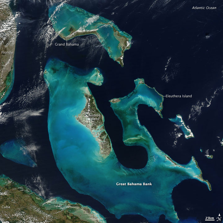
 The Bahamas from space. NASA Aqua satellite image, 2009.
 This short video shows the cloudy island of Cuba and the Bahamas as the ISS flies from the Caribbean Sea north-east to the Atlantic Ocean. In the video, you can see Cuba is mostly covered by clouds, but the reefs in the Bahamas stand out quite nicely.
The Bahamas is a group of about 700 atolls and cays in the western Atlantic Ocean, of which only between 30 and 40 are inhabited. The largest of the islands is Andros Island, located 120 miles (190 km) southeast of Florida. The Bimini islands are to its northwest. To the North is the island of Grand Bahama, home to the second largest city in the country, Freeport. The island of Great Abaco is to its east. In the far south is the island of Great Inagua, the second largest island in the country. Other notable islands include Eleuthera, Cat Island, San Salvador Island, Acklins, Crooked Island, and Mayaguana. Nassau is the capital and largest city, located on New Providence. The islands have a subtropical climate, moderated by the Gulf Stream.
The islands are surface projections of the three oceanic Bahama Banks - the Little Bahama Bank, the Great Bahama Bank, and the westernmost Cay Sal Bank. The highest point is only 63 meters above sea level on Cat Island; the island of New Providence, where the capital city of Nassau is located, reaches a maximum elevation of only thirty-seven meters. The land on the Bahamas has a foundation of fossil coral, but much of the rock is oolitic limestone; the stone is derived from the disintegration of coral reefs and seashells. The land is primarily either rocky or mangrove swamp. Low scrub covers much of the surface area. Pineyards are found on four of the northern islands: Grand Bahama, Great Abaco, New Providence, and Andros. On some of the southern islands, low-growing tropical hardwood flourishes. Although some soil is very fertile, it is also very thin. Only a few freshwater lakes and just one river, located on Andros Island, are found in the Bahamas.
Contents
Climate
Wettest tropical cyclones in the Bahamas Precipitation Storm Location Rank (mm) (in) 1 747.5 29.43 Noel 2007 Long Island[1] 2 508.0 20.00 Donna 1960 [2] 3 436.6 17.19 Flora 1963 Duncan Town[3] 4 390.1 15.36 Inez 1966 Nassau Airport[3] 5 337.1 13.27 Fox 1952 New Providence[4] 6 321.1 12.64 Michelle 2001 Nassau[5] 7 309.4 12.18 Erin 1995 Church Grove[6] 8 279.4 10.00 Isidore 1984 Nassau[7] 9 260.0 9.88 Fay 2008 Freeport[8] 10 236.7 9.32 Floyd 1999 Little Harbor Abacos[9] The climate of the archipelago is semitropical and has two seasons, summer and winter. During the summer, which extends from May through November, the climate is dominated by warm, moist tropical air masses moving north through the Caribbean. Midsummer temperatures range from 74 to 89 °F (23.3 to 31.7 °C) with a relative humidity of 60 to 100%. In winter months, extending from December through April, the climate is affected by the movement of cold polar masses from North America. Temperatures during the winter months range from 62 to 77 °F (16.7 to 25 °C).
While there has never been a freeze reported in the Bahamas, the temperature can fall to 37 °F (2.8 °C) during Arctic outbreaks that affect nearby Florida. Snow has been reported to have mixed with rain in Freeport in January 1977, the same time that it snowed in the Miami area. The temperature was about 41 °F (5 °C) at the time.
Yearly rainfall averages 55.7 inches (1,410 mm) and is usually concentrated in the May–June and August–October periods. Rainfall often occurs in short-lived, fairly intense showers accompanied by strong gusty winds, which are then followed by clear skies.
Winds are predominantly easterly throughout the year but tend to become northeasterly from October to April and southeasterly from May to September. These winds seldom exceed twenty-four kilometers per hour except during hurricane season. Although the hurricane season officially lasts from June to November, most hurricanes in the Bahamas occur between July and October. Before a long lull in activity which ended in the 1990s, the last one to strike was Hurricane David in September 1979. Damage was estimated at US$1.8 million and mainly affected agricultural products. The most intense twentieth-century hurricane to strike the Bahamas was the 1929 Florida hurricane; winds of up to 140 miles per hour (230 km/h) were recorded. Many lives were lost, and there was extensive damage to buildings, homes, and boats.
Climate data for Nassau Airport, Bahamas Month Jan Feb Mar Apr May Jun Jul Aug Sep Oct Nov Dec Year Average high °F 77.4 77.5 79.7 81.9 84.6 87.3 89.1 89.2 88.3 85.5 81.9 78.6 83.4 Average low °F 62.1 62.4 63.9 66.2 69.8 73.2 74.7 74.8 74.5 72 68 63.9 68.8 Precipitation inches 1.9 1.7 1.6 2.2 4.8 9.5 6.5 8.9 7 7.2 2.3 2.1 55.7 Average high °C 25.2 25.3 26.5 27.7 29.2 30.7 31.7 31.8 31.3 29.7 27.7 25.9 28.56 Average low °C 16.7 16.9 17.7 19.0 21.0 22.9 23.7 23.8 23.6 22.2 20.0 17.7 20.43 Precipitation mm 47.2 40.3 39.8 53.8 116.3 232.9 157.7 215.9 171.4 175.5 56.6 51.8 1,359.2 % humidity 78 78 76 74 77 79 77 79 81 80 78 78 77.92 Source: World Cliimate [10] Geography
Location
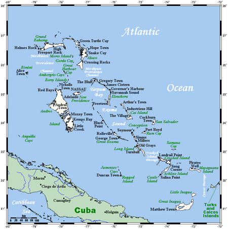 Map of the Bahamas
Atlantic Ocean, chain islands in the North Atlantic Ocean, southeast of Florida, northeast of Cuba and northwest of the Turks and Caicos Islands.
Geographic coordinates
24°14′N 76°00′W / 24.233°N 76°W
Area
- total: 13,940 km²
- county comparison to the world: 168
- land: 10 070 km²
- water: 3 870 km²
Area comparative
- Australia comparative: 6 times larger than the Australian Capital Territory
- Canada comparative: a little over twice the size of Prince Edward Island
- Poland comparative: slightly smaller than Świętokrzyskie Voivodeship
- United Kingdom comparative: slightly smaller than Northern Ireland
- United States comparative: slightly smaller than Connecticut
Land
Natural resources
- salt, aragonite, timber, arable land
Land use
- arable land: 0.58%
- permanent crops: 0.29%
- other: 99.13% (2005)
Coastline
- 3,542 km
Terrain
- long, flat coral formations with some low rounded hills
Elevation extremes
- lowest point: Atlantic Ocean 0 m
- highest point: Mount Alvernia on Cat Island 63 meters (206.7 feet)
Irrigated land
- 10 km2 (2003)
Environment
Natural hazards
- Hurricanes and other tropical storms that cause extensive flood and wind damage.
Environment - Current issues
- Coral reef decay
- Solid waste disposal
Environment - International agreements
Party to these agreements:
- Biodiversity, Climate Change, Climate Change-Kyoto Protocol, Desertification, Endangered Species, Hazardous Wastes, Law of the Sea, Ozone Layer Protection, Ship Pollution, Wetlands
Geography - note
- strategic location adjacent to US and Cuba
- extensive island chain of which 30 islands are inhabited
See also
- Islands of the Bahamas
- Wikimedia Atlas of the Bahamas
References
- ^ Brown, Daniel (2007-12-17). "Tropical Cyclone Report: Hurricane Noel (28 October - 2 November 2007)". National Hurricane Center. http://www.nhc.noaa.gov/pdf/TCR-AL162007_Noel.pdf. Retrieved 2007-12-25.
- ^ Turks and Caicos Islands Red Cross (2007). Turks and Caicos Islands 2007 Hurricane Guide. Retrieved on 2008-06-15.
- ^ a b David Roth (2009). Tropical Cyclone Rainfall Maxima. Hydrometeorological Prediction Center. Retrieved on 2007-03-15.
- ^ David M. Roth (2010-08-11). "Hurricane Fox (1952) Color-Filled Rainfall Graphic". Hydrometeorological Prediction Center.
- ^ Beven, Jack (2002-01-23). "Tropical Cyclone Report: Hurricane Michelle (29 October - 5 November 2001)". National Hurricane Center. http://www.nhc.noaa.gov/2001michelle.html. Retrieved 2007-12-25.
- ^ Rappaport, Edward (1995-11-26). "Preliminary Report: Hurricane Erin (31 July - 6 August 1995)". National Hurricane Center. http://www.nhc.noaa.gov/1995erin.html. Retrieved 2007-12-25.
- ^ Associated Press (1984-09-27). "Floridians Batten Down As Storm Gains Strength". Daily Herald. http://thehurricanearchive.com/Viewer.aspx?img=24763142_clean&firstvisit=true&src=search¤tResult=8¤tPage=10. Retrieved 2009-05-03.
- ^ Stacey R. Stewart and John L. Beven III (2009). Tropical Cyclone Report: Tropical Storm Fay 15-26 August 2008. National Hurricane Center. Retrieved on 2009-02-09.
- ^ Pasch, Richard (1999-11-18). "Preliminary Report: Hurricane Floyd (7 - 17 September 1999)". National Hurricane Center. http://www.nhc.noaa.gov/1999floyd.html. Retrieved 2007-12-25.
- ^ "World Climate". http://www.worldclimate.com. Retrieved November 8, 2010.
 This article incorporates public domain material from websites or documents of the Library of Congress Country Studies.
- This article incorporates public domain material from websites or documents of the CIA World Factbook.
Further reading
- Chenoweth, Michael (1998). "The Early 19th Century Climate of the Bahamas and a Comparison with 20th Century Averages". Climatic Change 40 (3–4): 577–603. doi:10.1023/A:1005371320672.
Bahamas topics Overviews Outline of the Bahamas · Index of Bahamas-related articlesGovernment and politics History Economy and infrastructure Geography and environment Culture and society Judicature Supreme Court of the BahamasMilitary and Police Sovereign states Antigua and Barbuda · Bahamas · Barbados · Belize · Canada · Costa Rica · Cuba · Dominica · Dominican Republic · El Salvador · Grenada · Guatemala · Haiti · Honduras · Jamaica · Mexico · Nicaragua · Panama · Saint Kitts and Nevis · Saint Lucia · Saint Vincent and the Grenadines · Trinidad and Tobago · United States
Dependencies and
other territoriesAnguilla · Aruba · Bermuda · Bonaire · British Virgin Islands · Cayman Islands · Curaçao · Greenland · Guadeloupe · Martinique · Montserrat · Navassa Island · Puerto Rico · Saint Barthélemy · Saint Martin · Saint Pierre and Miquelon · Saba · Sint Eustatius · Sint Maarten · Turks and Caicos Islands · United States Virgin Islands
Climate of North America Sovereign states Antigua and Barbuda · Bahamas · Barbados · Belize · Canada · Costa Rica · Cuba · Dominica · Dominican Republic · El Salvador · Grenada · Guatemala · Haiti · Honduras · Jamaica · Mexico · Nicaragua · Panama · Saint Kitts and Nevis · Saint Lucia · Saint Vincent and the Grenadines · Trinidad and Tobago · United States
Dependencies and
other territoriesAnguilla · Aruba · Bermuda · Bonaire · British Virgin Islands · Cayman Islands · Curaçao · Greenland · Guadeloupe · Martinique · Montserrat · Puerto Rico · Saint Barthélemy · Saint Martin · Saint Pierre and Miquelon · Saba · Sint Eustatius · Sint Maarten · Turks and Caicos Islands · United States Virgin Islands
Categories:

Wikimedia Foundation. 2010.