- Geography of Antigua and Barbuda
-
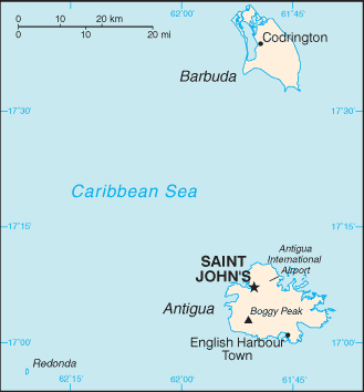
Antigua and Barbuda  Map of Antigua and Barbuda
Continent North America Subregion Caribbean Geographic coordinates 17°03′N 61°48′W / 17.05°N 61.8°W Area
- Total
- WaterRanked 205th
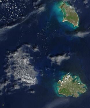
442.6 km²Coastline 153 km Land boundaries 0 km Countries bordered n/a Highest point Mount Obama, 402 m Lowest point Atlantic Ocean, 0 m Longest river none Largest inland body of water Terrain: low-lying limestone and coral islands, with some higher volcanic areas Natural resources NEGL Natural hazards hurricanes and tropical storms (July to October); periodic droughts Environmental issues water management, deforestation  Satellite image of Antigua and Barbuda
Antigua and Barbuda lie in the eastern arc of the Leeward Islands of the Lesser Antilles, separating the Atlantic Ocean from the Caribbean Sea. Antigua is 650 km southeast of Puerto Rico; Barbuda lies 48 km due north of Antigua, and the uninhabited island of Redonda is 56 km southwest of Antigua. The largest island, Antigua, is 21 km (about a dozen miles) across and 281 km² (about a hundred square miles) in area, or about two-thirds the size of New York City, seven eighths the area of Inner London or 86% greater than the London Borough of Bromley. Barbuda covers 161 km² (about 5% more than Bromley), while Redonda encompasses a mere 2.6 km² making it comparable to The City of London, about 1 square mile (3 km2). The capital of Antigua and Barbuda is St. John's, located at St. John's Harbour on the northwest coast of Antigua. The principal city of Barbuda is Codrington, located on Codrington Lagoon.
Contents
Mountains and Hills
Antigua and Barbuda both are generally low-lying islands whose terrain has been influenced more by limestone formations than volcanic activity. The highest point on Antigua, however, is Mount Obama (formerly Boggy Peak), the remnant of a volcanic crater rising 399 metres (1309 ft). This mountain is located amid a bulge of hills of volcanic origin in the southwestern part of the island. The limestone formations in the northeast are separated from the southwestern volcanic area by a central plain of clay formations. Barbuda's highest elevation is 44.5 metres (146 ft), part of the highland plateau east of Codrington. The shorelines of both islands are greatly indented, with beaches, lagoons, and natural harbours. The islands are rimmed by reefs and shoals. There are few streams, as rainfall is slight. Both islands lack adequate amounts of fresh groundwater. Redonda has no significant elevation.
Neither Barbuda nor Redonda have any significant elevations.
The Coast, Islands, and the Ocean
Oceans and Seas
Antigua and Barbuda are located in the eastern Caribbean Sea. The open Atlantic Ocean lies to the north and east. There are many coral reefs in the vicinity of Antigua and Barbuda. The island of Guadeloupe lies to the south, on the far side of the Guadeloupe Passage from Antigua.
The Coast and Beaches
Antigua and Barbuda is famous for its beaches, estimated at 365, particularly those on Antigua itself. The most noteworthy feature of Barbuda’s coastline is the natural lagoon on the western side of the island.
Climate
Wind
The islands' tropical climate is moderated by fairly constant northeast tradewinds, with velocities ranging between 30 and 48 km/h (19 and 30 mph). There is little precipitation, however, because of the islands' low elevations.
Rainfall and temperature
Rainfall averages 990 mm (39 in) per year, but the amount varies widely from season to season. In general, the wettest period is between September and November. The islands generally experience low humidity and recurrent droughts. Hurricanes strike on an average of once a year. Temperatures average 27 °C (80.6 °F), with a range from 23 °C (73.4 °F) in the winter to 30 °C (86 °F) in the summer and autumn; the coolest period is between December and February. Its low humidity makes it one of the most temperate climates in the world.
Vegetation
The sandy soil on much of the islands has only scrub vegetation. Some parts of Antigua are more fertile–most notably the central plain–due to the volcanic ash in the soil. These areas support some tropical vegetation, and agricultural uses. The planting of acacia, mahogany, and red and white cedar on Antigua has led to as much as 11% of the land becoming forested, helping to conserve the soil and water.
Statistics
- Location
- Antigua and Barbuda are Caribbean islands between the Caribbean Sea and the North Atlantic Ocean, east-southeast of Puerto Rico
- Geographic coordinates
- 17°03′N 61°48′W / 17.05°N 61.8°W
- Map references
- Central America and the Caribbean
- Area
-
- Total: 442.6 km² (Antigua 280 km²; Barbuda 161 km²)
- :country comparison to the world: 205
- Land: 442.6 km²
- Water: 0 km²
- Note: Includes Redonda, 1.6 km²
- Area comparative
-
- Australia comparative: 5 times smaller than the Australian Capital Territory
- Canada comparative: about the same size as St. John's
- United Kingdom comparative: slightly larger than the Isle of Wight
- United States comparative: 2.5 times the size of Washington, DC
- Land boundaries
- 0 km
- Coastline
- 153 km
- Maritime claims
-
- Contiguous zone: 24 nautical miles (44.4 km; 27.6 mi)
- Continental shelf: 200 nautical miles (370.4 km; 230.2 mi) or to the edge of the continental margin
- Exclusive economic zone: 200 nautical miles (370.4 km; 230.2 mi)
- Territorial sea: 12 nautical miles (22.2 km; 13.8 mi)
- Climate
- Tropical marine; little seasonal temperature variation
- Terrain
- Mostly low-lying limestone and coral islands, with some higher volcanic areas
- Elevation extremes
-
- Lowest point: Caribbean Sea 0 m
- Highest point: Mount Obama 402 m
- Natural resources
- NEGL; pleasant climate fosters tourism
- Land use
-
- Arable land: 18.18%
- Permanent crops: 4.55%
- Other: 77.27% (2005)
- Irriganted land
- n/a
- Total renewable water resources
- 0.1 km3 (0.024 cu mi) (2000)
- Freshwater withdrawal (domestic/industrial/agricultural)
-
- Total: 0.005 km3 (0.0012 cu mi)/yr (60%/20%/20%)
- Per capita: 63 m3 (82 cu yd)/yr (2000)
- Natural hazards
- Hurricanes and tropical storms (July to October); periodic droughts
- Environment
- current issues
- Water management, a major concern because of limited natural fresh water resources, is further hampered by the clearing of trees to increase crop production, causing rainfall to run off quickly
- Environment
- international agreements
- Party to: Biodiversity, Climate Change, Climate Change-Kyoto Protocol, Desertification, Endangered Species, Environmental Modification, Hazardous Wastes, Law of the Sea, Marine Dumping, Nuclear Test Ban, Ozone Layer Protection, Ship Pollution, Wetlands, Whaling
- Signed, but not ratified: None of the selected agreements
- Geography - note
- Antigua has a deeply indented shoreline with many natural harbors and beaches; Barbuda has a large western harbor
References
 This article incorporates public domain material from websites or documents of the Library of Congress Country Studies.
- This article incorporates public domain material from websites or documents of the CIA World Factbook.
Sovereign states Antigua and Barbuda · Bahamas · Barbados · Belize · Canada · Costa Rica · Cuba · Dominica · Dominican Republic · El Salvador · Grenada · Guatemala · Haiti · Honduras · Jamaica · Mexico · Nicaragua · Panama · Saint Kitts and Nevis · Saint Lucia · Saint Vincent and the Grenadines · Trinidad and Tobago · United States
Dependencies and
other territoriesAnguilla · Aruba · Bermuda · Bonaire · British Virgin Islands · Cayman Islands · Curaçao · Greenland · Guadeloupe · Martinique · Montserrat · Navassa Island · Puerto Rico · Saint Barthélemy · Saint Martin · Saint Pierre and Miquelon · Saba · Sint Eustatius · Sint Maarten · Turks and Caicos Islands · United States Virgin Islands
Climate of North America Sovereign states Antigua and Barbuda · Bahamas · Barbados · Belize · Canada · Costa Rica · Cuba · Dominica · Dominican Republic · El Salvador · Grenada · Guatemala · Haiti · Honduras · Jamaica · Mexico · Nicaragua · Panama · Saint Kitts and Nevis · Saint Lucia · Saint Vincent and the Grenadines · Trinidad and Tobago · United States
Dependencies and
other territoriesAnguilla · Aruba · Bermuda · Bonaire · British Virgin Islands · Cayman Islands · Curaçao · Greenland · Guadeloupe · Martinique · Montserrat · Puerto Rico · Saint Barthélemy · Saint Martin · Saint Pierre and Miquelon · Saba · Sint Eustatius · Sint Maarten · Turks and Caicos Islands · United States Virgin Islands
Categories:
Wikimedia Foundation. 2010.