- Climate of the United States
-
For change, see Climate change in the United States.
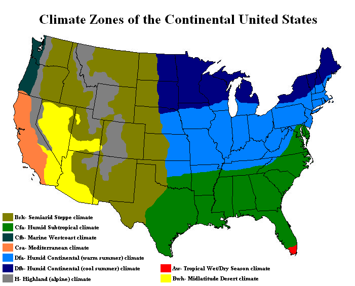
 Climate zones of the Continental United States.
The United States includes a wide variety of climate types due to its large size, range of geographic features, and non-contiguous arrangement. In the contiguous United States to the east of the 100th meridian, the climate ranges from humid continental in the north to humid subtropical in the south. The southern tip of Florida is tropical. The Great Plains west of the 100th meridian are semi-arid. Much of the Rocky Mountains, the Sierra Nevada, and the Cascade Range are alpine. The climate is arid in the Great Basin, desert in the Southwest, Mediterranean in coastal California, and oceanic in coastal Oregon and Washington. The state of Alaska—on the northwestern corner of the North American continent—is largely subarctic, with an oceanic climate in its southern edge and a polar climate in the north. The archipelago state of Hawaii, in the middle of the Pacific Ocean, is tropical.
Extreme weather is not uncommon—the states bordering the Gulf of Mexico are prone to hurricanes, and tornadoes regularly occur in the area of the Midwest referred to as Tornado Alley. The United States has more tornadoes than the rest of the countries of the world combined.[1]
Contents
Overview

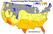 A map of the average annual high temperatures in the United States.
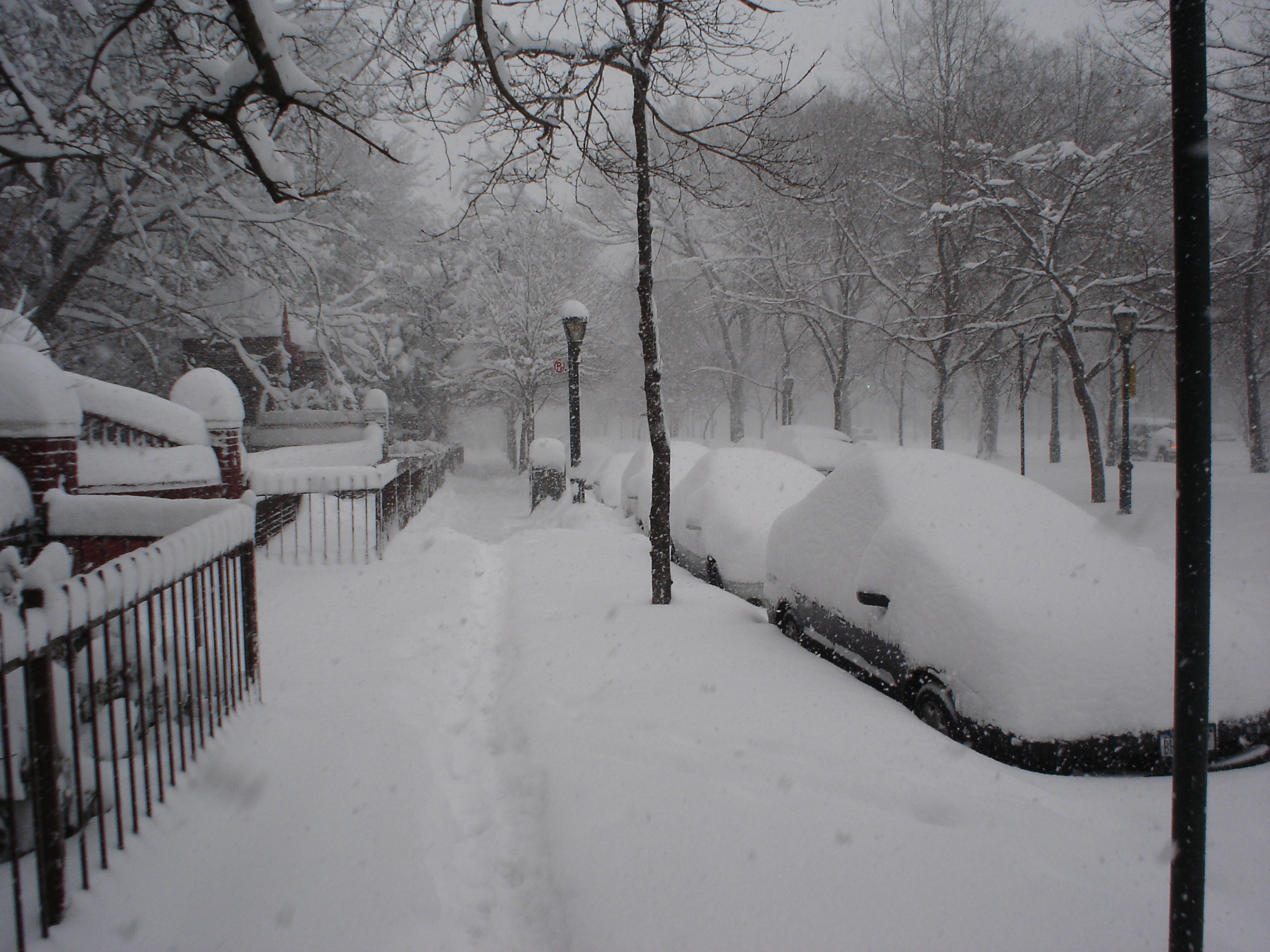
The main influence on weather in the United States is the polar jet stream, which brings in large low pressure systems from the northern Pacific Ocean. Once a Pacific cyclone moves over the Great Plains, uninterrupted flat land allows it to reorganize and can lead to major clashes of air masses. Sometimes during late winter and spring these storms can combine with another low pressure system as they move up the East Coast and into the Atlantic Ocean, where they intensify rapidly. These storms are known as Nor'easters and often bring widespread, heavy snowfall to the Mid-Atlantic and New England. The uninterrupted flat grasslands of the Great Plains also leads to some of the most extreme climate swings in the world. Temperatures can rise or drop rapidly; winds can be extreme; and the flow of heat waves or Arctic air masses often advance uninterrupted through the plains.
The Great Basin and Columbia Plateau (the Intermontane Plateaus) are arid or semiarid regions that lie in the rain shadow of the Cascades and Sierra Nevada. Precipitation averages less than 15 inches (38 cm). The Southwest is a hot desert, with temperatures exceeding 100°F (38°C) for several weeks at a time in summer. The Southwest and the Great Basin are also affected by the monsoon from the Gulf of California from July-September, which brings localized but often severe thunderstorms to the region.
Precipitation
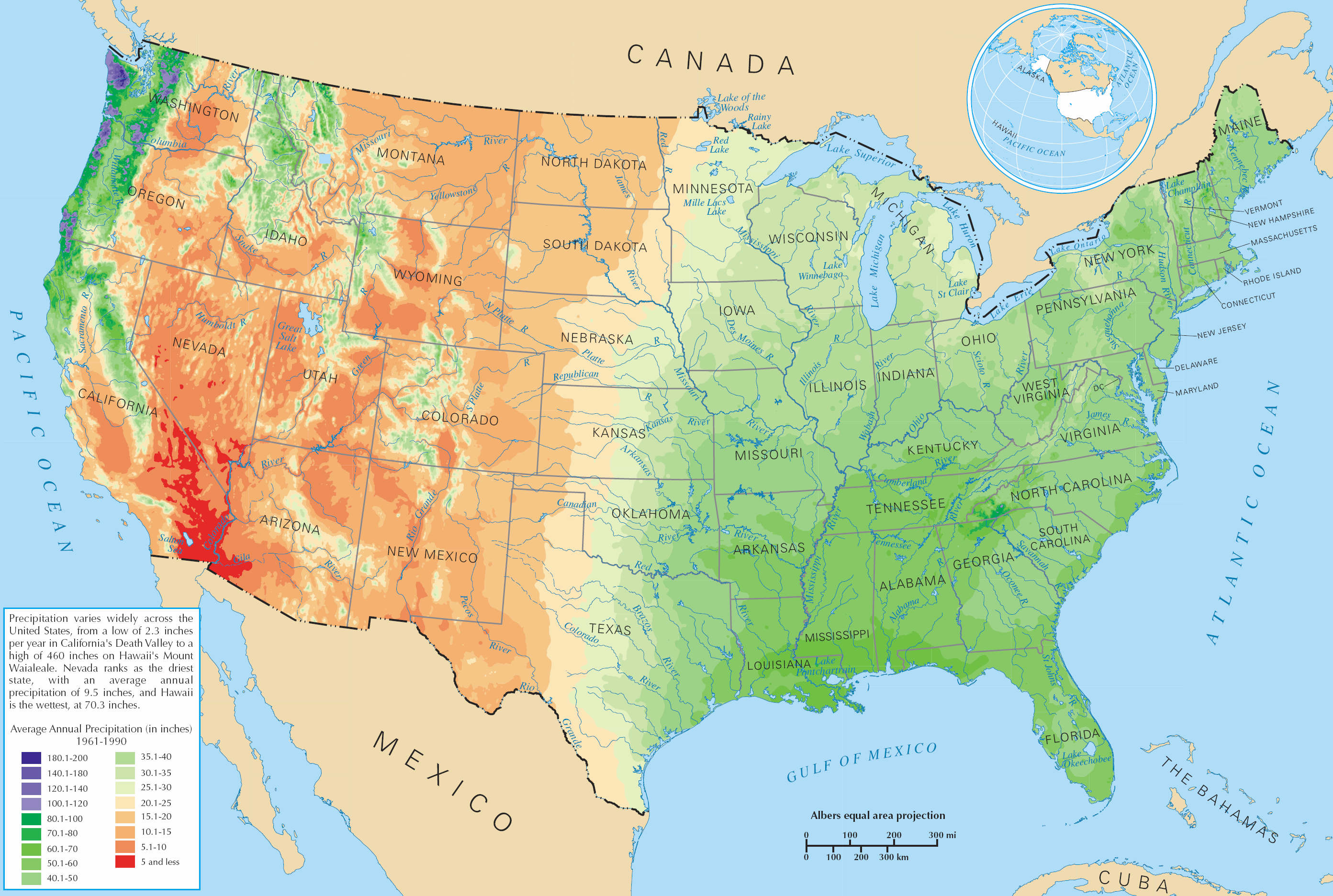
 Average precipitation.See also: United States rainfall climatology
The characteristics of rainfall across the United States differ significantly across the United States and its possessions. Late summer and fall extratropical cyclones bring a majority of the precipitation which falls across western, southern, and southeast Alaska annually. During the fall, winter, and spring, Pacific storm systems bring most of Hawaii and the western United States much of their precipitation.[2] Nor'easters moving up the East coast bring cold season precipitation to the Mid-Atlantic and New England states.[3] Lake-effect snows add to precipitation potential downwind of the Great Lakes,[4] as well as Great Salt Lake and the Finger Lakes during the cold season. The snow to liquid ratio across the contiguous United States is 13:1, meaning 13 inches (330 mm) of snow melts down to 1 inch (25 mm) of water.[5] The El Niño-Southern Oscillation affects the precipitation distribution, by altering rainfall patterns across the West, Midwest, the Southeast, and throughout the tropics.[6][7][8][9]
During the summer, the Southwest monsoon combined with Gulf of California and Gulf of Mexico moisture moving around the subtropical ridge in the Atlantic ocean bring the promise of afternoon and evening thunderstorms to the southern tier of the country as well as the Great Plains.[10] Equatorward of the subtropical ridge, tropical cyclones enhance precipitation across southern and eastern sections of the country, as well as Puerto Rico, the United States Virgin Islands, the Northern Mariana Islands, Guam, and American Samoa.[11] Over the top of the ridge, the jet stream brings a summer precipitation maximum to the Great Lakes. Large thunderstorm areas known as mesoscale convective complexes move through the Plains, Midwest, and Great Lakes during the warm season, contributing up to 10% of the annual precipitation to the region.[12]
Extremes
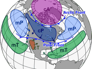
 Several different air masses affect the United States.
In northern Alaska, tundra and arctic conditions predominate, and the temperature has fallen as low as −80 °F (−62 °C).[13] On the other end of the spectrum, Death Valley, California once reached 134 °F (56.7 °C), the second-highest temperature ever recorded on Earth.[14]
On average, the mountains of the western states receive the highest levels of snowfall on Earth. The greatest annual snowfall level is at Mount Rainier in Washington, at 692 inches (1,758 cm); the record there was 1,122 inches (2,850 cm) in the winter of 1971–72. This record was broken by the Mt. Baker Ski Area in northwestern Washington which reported 1,140 inches (2,896 cm) of snowfall for the 1998-99 snowfall season. Other places with significant snowfall outside the Cascade Range are the Wasatch Mountains, near the Great Salt Lake and the Sierra Nevada, near Lake Tahoe.
Along the coastal mountain ranges in the Pacific Northwest, rainfall is greater than anywhere else in the continental U.S., with Quinault Ranger Station in Washington having an average of 137 inches (3,480 mm).[15] Hawaii receives even more, with 460 inches (11,684 mm) measured annually, on average, on Mount Waialeale, in Kauai.[16] The Mojave Desert in the southwest is home to the driest locale in the U.S. Yuma, Arizona, has an average of 2.63 inches (67 mm) of precipitation each year.[17]
Climate data for United States Month Jan Feb Mar Apr May Jun Jul Aug Sep Oct Nov Dec Year Record high °F (°C) 98
(37)105
(41)108
(42)118
(48)124
(51)129
(54)134
(57)127
(53)126
(52)116
(47)105
(41)100
(38)134
(57)Record low °F (°C) −80
(−62)−75
(−59)−68
(−56)−50
(−46)−25
(−32)−1
(−18)10
(−12)5
(−15)−13
(−25)−48
(−44)−61
(−52)−72
(−58)−80
(−62)Source: http://www.infoplease.com/ipa/A0762182.html Natural disasters
See also: Floods in the United States, List of United States hurricanes, and Tornadoes in the United States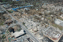
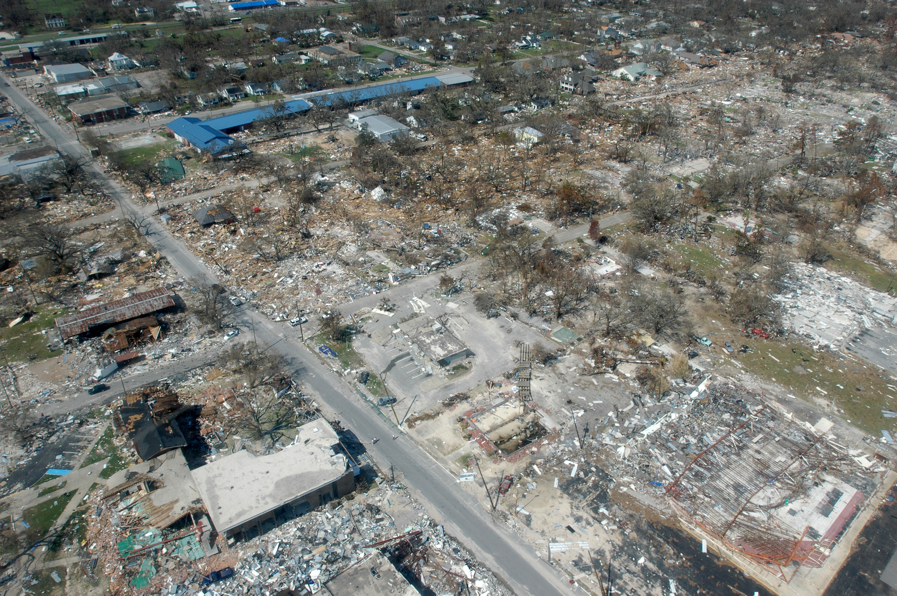
The United States is affected by a large variety of weather related natural disasters. Deadly and destructive hurricanes occur almost every year along the Atlantic seaboard and the Gulf of Mexico.[18] Hurricanes can also strike Hawaii in the Pacific Ocean.[19] Particularly at risk are the central and southern Texas coasts, the area from southeastern Louisiana east to the Florida Panhandle, the east coast of Florida, and the Outer Banks of North Carolina. Hurricane season runs from June 1 to November 30, with a peak from mid-August through early October.[20] Some of the more devastating hurricanes have included the Galveston Hurricane of 1900,[21] Hurricane Andrew in 1992,[22] and Hurricane Katrina in 2005.[23] The remnants of tropical cyclones from the Eastern Pacific also occasionally impact the southwestern United States, bringing sometimes heavy rainfall.[24]
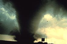 A powerful tornado in Texas.
The Great Plains and Midwest, because of the contrasting air masses, have frequent severe thunderstorms and tornado outbreaks during spring and summer. In central portions of the U.S., tornadoes are more common than anywhere else on Earth[25] and touch down most commonly in the spring and summer. The strip of land from north Texas north to Nebraska and east into Southern Michigan is known as Tornado Alley, where many houses have tornado shelters and many towns have tornado sirens.
The Appalachian region and the Midwest experience the worst floods. Widespread severe flooding is rare. Some exceptions include the Great Mississippi Flood of 1927, the Great Flood of 1993, and widespread flooding and mudslides caused by the 1982-1983 El Niño event in the western United States. Localized flooding can, however, occur anywhere, and mudslides from heavy rain can cause problems in any mountainous area, particularly the Southwest. The narrow canyons of many mountain areas in the west and severe thunderstorm activity during the monsoon season in summer leads to sometimes devastating flash floods as well, while Nor'easter snowstorms can bring activity to a halt throughout the Northeast (although heavy snowstorms can occur almost anywhere).
The Southwest has the worst droughts; one is thought to have lasted over 500 years and to have decimated the Anasazi people.[26] Large stretches of desert shrub in the west can fuel the spread of wildfires. Although severe drought is rare, it has occasionally caused major problems, such as during the Dust Bowl (1931–1942), which coincided with the Great Depression. Farmland failed throughout the Plains, entire regions were virtually depopulated, and dust storms ravaged the land. More recently, the western U.S. experienced widespread drought from 1999-2004.
Hurricanes - Sunspot theory
A 2010 report correlates low sunspot activity with high hurricane activity. Analyzing historical data, there was a 25% chance of at least one hurricane striking the continental US during a peak sunspot year; a 64% chance during a low sunspot year. In June 2010, the hurricanes predictors in the US were not using this information.[27][dead link]
See also
References
- ^ Charles A. Doswell III. Severe Storms. Retrieved on 2008-03-22.
- ^ Norman W. Junker. West Coast Cold Season Heavy Rainfall Events. Retrieved on 2008-03-01.
- ^ George J. Maglaras, Jeff S. Waldstreicher, Paul J. Kocin, Anthony F. Gigi, and Robert A. Marine. Winter Weather Forecasting throughout the Eastern United States. Part 1: An Overview. Retrieved on 2008-03-01.
- ^ Thomas W. Schmidlin. Climatic Summary of Snowfall and Snow Depth in the Ohio Snowbelt at Chardron. Retrieved on 2008-03-01.
- ^ Martin A. Baxter, Charles E. Graves, and James T. Moore. A Climatology of Snow-to-Liquid Ratio for the Contiguous United States. Retrieved on 2008-03-21.
- ^ John Monteverdi and Jan Null. WESTERN REGION TECHNICAL ATTACHMENT NO. 97-37 NOVEMBER 21, 1997: El Niño and California Precipitation. Retrieved on 2008-02-28.
- ^ Nathan Mantua. La Niña Impacts in the Pacific Northwest. Retrieved on 2008-02-29.
- ^ Southeast Climate Consortium. SECC Winter Climate Outlook. Retrieved on 2008-02-29.
- ^ Reuters. La Nina could mean dry summer in Midwest and Plains. Retrieved on 2008-02-29.
- ^ National Weather Service Forecast Office Flagstaff, Arizona. The Monsoon. Retrieved on 2008-02-28.
- ^ David M. Roth. Tropical Cyclone Maxima per U. S. State. Retrieved on 2008-03-02.
- ^ Walker S. Ashley, Thomas L. Mote, P. Grady Dixon, Sharon L. Trotter, Emily J. Powell, Joshua D. Durkee, and Andrew J. Grundstein. Distribution of Mesoscale Convective Complex Rainfall in the United States. Retrieved on 2008-03-02.
- ^ Williams, Jack Each state's low temperature record, USA today, URL accessed 13 June 2006.
- ^ "Weather and Climate" (PDF). Official website for Death Valley National Park. National Park Service U. S. Department of the Interior. January 2002. pp. 1–2. http://www.nps.gov/deva/planyourvisit/upload/Weather.pdf. Retrieved October 5, 2006.
- ^ National Atlas. Average Annual Precipitation, 1961-1990. Retrieved on 2006-06-15.
- ^ Diana Leone. Rain supreme. Retrieved on 2008-03-19.
- ^ Hereford, Richard, et al., Precipitation History of the Mojave Desert Region, 1893–2001, U.S. Geological Survey, Fact Sheet 117-03, URL accessed 13 June 2006.
- ^ Hurricane Research Division. Chronological List of All Hurricanes which Affected the Continental United States: 1851-2005. Retrieved on 2008-03-02.
- ^ Central Pacific Hurricane Center. Previous Tropical Systems in the Central Pacific. Retrieved on 2008-03-02.
- ^ National Hurricane Center. Peak of Season Graphic. Retrieved on 2008-03-02.
- ^ The Galveston storm of 1900—The deadliest disaster in American history. National Oceanic and Atmospheric Administration. Retrieved on 2007-12-18.
- ^ Ed Rappaport (1993). "Hurricane Andrew Preliminary Report". National Hurricane Center. http://www.nhc.noaa.gov/1992andrew.html. Retrieved 2007-08-27.
- ^ Knabb, Richard D; Rhome, Jamie R.; Brown, Daniel P (December 20, 2005; updated August 10, 2006). "Tropical Cyclone Report: Hurricane Katrina: 23–30 August 2005" (PDF). National Hurricane Center. http://www.nhc.noaa.gov/pdf/TCR-AL122005_Katrina.pdf. Retrieved 2006-05-30.
- ^ David M. Roth. Tropical Cyclones in the West. Retrieved on 2008-03-02.
- ^ NOVA, Tornado Heaven, Hunt for the Supertwister, URL accessed 15 June 2006.
- ^ O'Connor, Jim E. and John E. Costa, Large Floods in the United States: Where They Happen and Why, U.S. Geological Survey Circular 1245, URL accessed 13 June 2006.
- ^ Waymer, Jim (1 June 2010). "Researchers:Fewer sunspots, more storms". Melbourne, Florida: Florida Today. pp. 1A. http://www.floridatoday.com/article/20100601/NEWS01/6010319/Researchers-Fewer-sunspots-more-storms.[dead link]
External links
Climate of the United States States - Alabama
- Alaska
- Arizona
- Arkansas
- California
- Colorado
- Connecticut
- Delaware
- Florida
- Georgia
- Hawaii
- Idaho
- Illinois
- Indiana
- Iowa
- Kansas
- Kentucky
- Louisiana
- Maine
- Maryland
- Massachusetts
- Michigan
- Minnesota
- Mississippi
- Missouri
- Montana
- Nebraska
- Nevada
- New Hampshire
- New Jersey
- New Mexico
- New York
- North Carolina
- North Dakota
- Ohio
- Oklahoma
- Oregon
- Pennsylvania
- Rhode Island
- South Carolina
- South Dakota
- Tennessee
- Texas
- Utah
- Vermont
- Virginia
- Washington
- West Virginia
- Wisconsin
- Wyoming
Federal district Insular areas - American Samoa
- Guam
- Northern Mariana Islands
- Puerto Rico
- U.S. Virgin Islands
Climate of North America Sovereign states - Antigua and Barbuda
- Bahamas
- Barbados
- Belize
- Canada
- Costa Rica
- Cuba
- Dominica
- Dominican Republic
- El Salvador
- Grenada
- Guatemala
- Haiti
- Honduras
- Jamaica
- Mexico
- Nicaragua
- Panama
- Saint Kitts and Nevis
- Saint Lucia
- Saint Vincent and the Grenadines
- Trinidad and Tobago
- United States
Dependencies and
other territories- Anguilla
- Aruba
- Bermuda
- Bonaire
- British Virgin Islands
- Cayman Islands
- Curaçao
- Greenland
- Guadeloupe
- Martinique
- Montserrat
- Puerto Rico
- Saint Barthélemy
- Saint Martin
- Saint Pierre and Miquelon
- Saba
- Sint Eustatius
- Sint Maarten
- Turks and Caicos Islands
- United States Virgin Islands
Categories:


Wikimedia Foundation. 2010.