- North American blizzard of 2006
-
North American blizzard of 2006 NASA satellite image of the storm, featuring a hurricane-like "eye".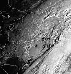
Storm type: Nor'easter Formed: February 11, 2006 Dissipated: February 13, 2006 Maximum
amount:*30.2 inches (76.7 cm) Lowest
pressure:971 mbar (hPa)[1] Damages: $5 million (2006 USD) Fatalities: 0 direct, 3 indirect Areas affected: Virginia, Maryland, District of Columbia, Pennsylvania, New York, New Jersey, Delaware, New England, Atlantic Canada ^* Maximum snowfall or ice accretion
The Blizzard of 2006 was a nor'easter that began on the evening of February 11, 2006. It dumped heavy snow across the Northeast United States from Virginia to Maine through the early evening of February 12 and ended in Atlantic Canada on February 13. The major northeast cities from Baltimore to Boston received at least a foot of snow, with an all-time largest amount of 26.9 inches (68.3 cm) in New York City, the most since at least 1869, the start of record keeping.
Contents
Meteorological information
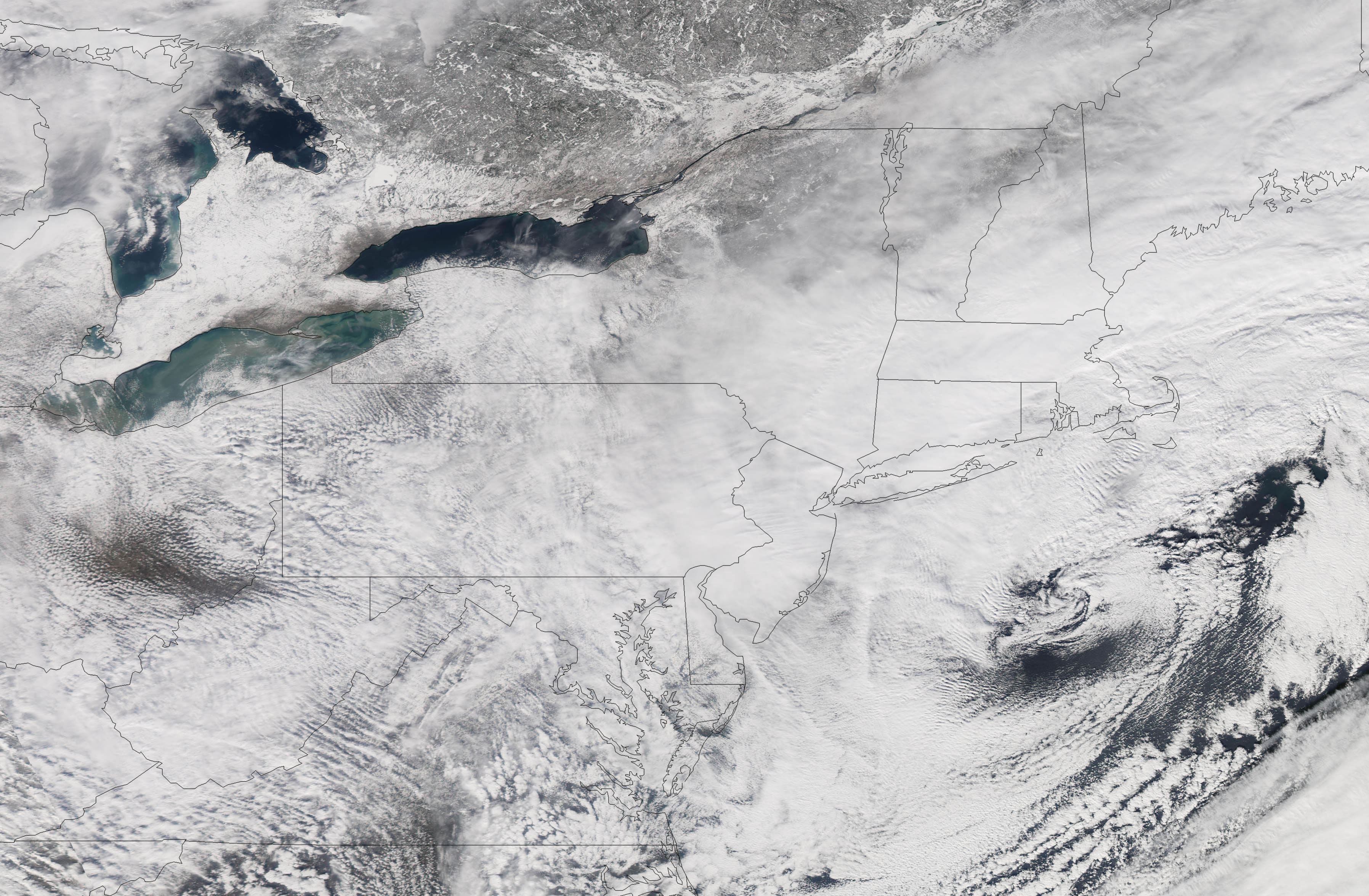
 Another NASA satellite image of the storm.
Since the heaviest snow was confined to a fairly small, but very heavily populated area, the storm was only ranked as a low-end Category 3 (Major) on the new Northeast Snowfall Impact Scale, which takes into account the area and population affected, as well as snowfall accumulations.[2] This indirectly also reflects that fact that casualties were extremely low and cleanup was fairly quick, even in the New York City area where the record snow amounts occurred. The main reasons for this are: A) The storm fell on a Sunday when many people can more easily stay home, B) the relatively small geographic area of extremely large snowfall, and C) Because the temperature was well below freezing throughout most of the storm, the snow was mostly dry and light in composition, as opposed to the wet and heavy snows that make some otherwise lesser storms much harder to clean up from and are more common at least in the coastal Northeast. Plus, temperatures in the days after the storm were unseasonably warm in some spots (reaching the mid-50s °F in hard-hit New York City, and the mid 60s in DC) which helped melt the snow much more quickly than usual.
The storm system began developing on February 11 as a relatively minor system, bringing some snow along the southern Appalachian range. The low pressure center moved off-shore early February 12 before it began its exponential intensification. By early morning, snow began falling at a massive rate, taking several forecasters by surprise who had expected about a foot of snow, at most, along the eastern fringes of the Atlantic seaboard. During the height of the storm on Sunday morning the 12th, thunder and lightning occurred as the snow fell. The presence of this thundersnow shows how energetic this storm became.
The reason for the extreme intensification was the result of a fairly mild winter that kept water temperatures in the Atlantic a few degrees warmer than they should have been for February. The storm system's intensity led to snowfall accumulations upwards of 32 inches (81.3 cm) in some localities.
In addition to the heavy snow, coastal flooding from storm surge was reported, particularly in Massachusetts.[3] Storm surges have been recorded as high as 3 feet (1 m) in parts of New England.[4]
The low pressure area began forming in the Southern states a few days prior to the Blizzard striking, eventually merging with a northern stream system. A trough on the East Coast brought the system up the coast, and cold to the north eventually slowed the system to a crawl. As the system completed bombing, or rapid decrease in central pressure (a common measure of the strength of a storm), mesoscale banding features (areas of significant snowfall associated with small scale physical phenomena) impinged on the entire I-95 Corridor.
The low pressure center was so deep that somewhat of an eye actually formed. Rarely do eyes form on storms other than hurricanes, and it is especially rare in extratropical cyclones. NASA took a satellite picture of the eye of the storm; the eye was located south and east of southern New Jersey in this picture.
Impact
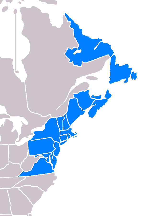
 A map of the states and provinces affected
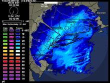 A radar reflectivity loop of the blizzard in the New York City area.
Three casualties occurred as a result of the snow: in Virginia, a man died due to his truck sliding off a highway; in Baltimore, a person died in a house fire as a result of snow delaying rescue workers from getting to the fire.[5] A third fatality occurred in a weather-related accident in Nova Scotia.[6]
Connecticut
While Connecticut was one of the hardest hit areas, the state was well-prepared for the storm and managed to avoid major problems. Hartford received a total of 21.9 inches (55 cm) of snow — the second largest snowfall since 1906. A total of 18 inches (46 cm) fell in the small Sandy Hook village.[7] West Hartford totaled 27 inches (69 cm) and Fairfield saw 27.8 inches (70.6 cm) of snow. Despite the large amounts of snow, there were only isolated individual power outages. At the storm's onset, governor M. Jodi Rell ordered all tractor-trailer trucks off the state's highways to facilitate the efforts of highway crews with snow removal. Motorists whose vehicles were not equipped with 4-wheel drive were required to use snow chains to travel on state roadways during the storm. Connecticut mobilized 2,500 state-owned and privately contracted snowplows to keep state highways open during the storm. The state's 169 cities and towns employed hundreds of additional plows to keep local roads passable. Bradley International Airport was closed for several hours, and the storm disrupted service on Metro North.
Delaware
New Castle County and Wilmington felt the brunt of this storm, with 14-15 inches (35–38 cm) of snow. Kent and Sussex counties to the south mixed with rain for a while, and saw significantly less snow accumulations, mostly in the 6 inch (15 cm) range.
District of Columbia
The city of Washington, D.C. missed the worst of the storm. The city received about 10 inches (24 cm) of snow, far less than in the suburbs. Approximately 3,000 people lost electricity in the District of Columbia.[8] However, Ronald Reagan Washington National Airport (just across the Potomac River) was closed.
Maryland
The heaviest snow in Maryland fell from the northern suburbs of Washington, D.C., to the Baltimore area. These areas overwhelmingly saw over a foot of snow. Snowfall rates of 2-3 inches (5–8 cm) per hour were common, and thundersnow occurred. Snowfall amounts of up to 21 inches (53 cm) were reported in Columbia, 13.1 inches (33.3 cm) in Baltimore, 17 inches (43 cm) in Catonsville, and a foot (30.5 cm) in Potomac. This was the area's heaviest snow since the North American blizzard of 2003. Lesser amounts occurred in western and southern parts of the state.
Maryland was hardest hit by power outages. In the Baltimore area, more than 62,000 people lost electricity, plus another 16,000 in Montgomery County and 37,000 in Prince George's County.
Massachusetts
The most serious coastal problems were in Massachusetts. The heaviest snow was in the central part of the state, where snow amounts of up to 20 inches (50 cm) were reported. Coastal areas, particularly around Nantucket, saw lesser amounts (approximately 12") as it was mixed with sleet at times, but winds of up to 60 mph (95 km/h) whipped up the ocean with storm surges of 2 to 3 feet (60 to 90 cm) and led to some coastal flooding, plus offshore waves of up to 25 feet (8 m). Logan International Airport in Boston and Barnstable municipal airport in Hyannis on Cape Cod saw over 90% of their flights cancelled at the peak of the storm.
There were no power outages, despite the conditions.[9] There was one death; a tree fell onto a pickup truck in Billerica, killing the driver.[10] Strong winds across the state caused $1.9 million in damage (2006 USD).[11]
New Jersey
The impact of the blizzard in northern New Jersey was strong enough to stop the New Jersey Transit bus service between 7:30 a.m. and 4:00 p.m., although trains continued to run (with some delays).[12] Many roads remained closed. Businesses were closed for most of the day. 16,000 people were without power in the state. Central and northeastern New Jersey saw the brunt of the storm due to heavy banding through the night into the morning: 21" (53.3 cm) of snow fell at Newark Airport and 27" fell in Rahway.
New York
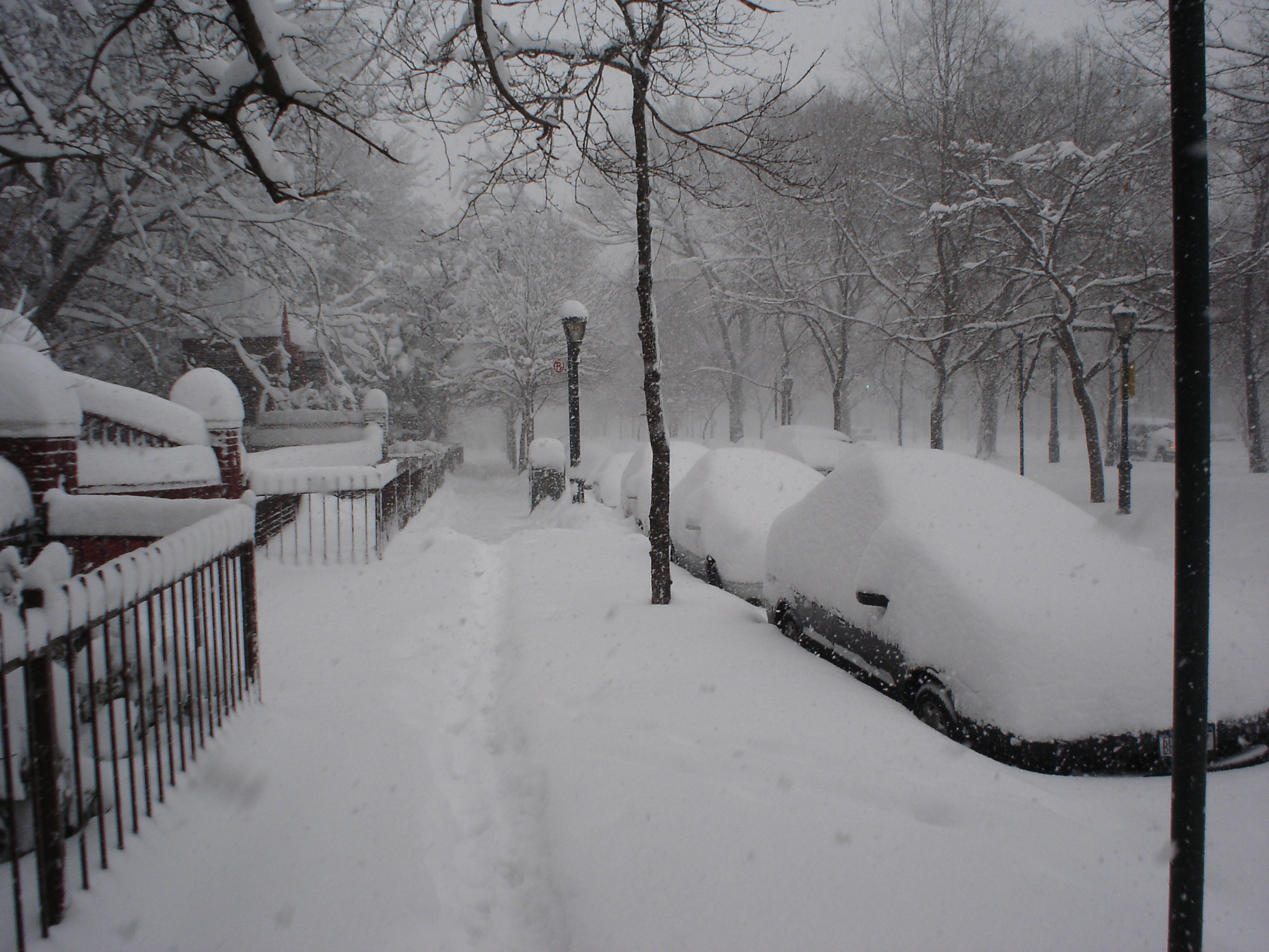
 Prospect Heights, Brooklyn on February 12.
The Greater New York City area received the brunt of the February Blizzard of 2006. All three of the airports in the New York City area (LaGuardia Airport, John F. Kennedy International Airport and Newark Liberty International Airport) were closed during the record blizzard, for the first time since the September 11, 2001 attacks. Like the Blizzard of 1996, this winter storm does not meet the criteria to be called a blizzard, however. The winds were not strong enough, and visibility was not poor enough. Thundersnow, which is a rare occurrence in New York, occurred for about a 4 hour period in parts of Bronx, Manhattan, Brooklyn, Queens, Rockland and Westchester during the height of the storm early Sunday morning.
Central Park received 26.9 inches (68.3 cm) of snow, the largest amount for a single storm since records began, breaking the record of 26.4 inches (67.1 cm) that fell on December 26, 1947. By comparison, the blizzards of 1996 and 2003 dropped 20.2 and 19.8 inches (51.3 and 50.3 cm) in Central Park respectively. The smallest amounts of snowfall were recorded in portions of Nassau County, including the towns of Oceanside, Lynbrook, Rockville Centre and Island Park. The snow removal cost in New York City alone is estimated at about $27 million.[13] It took nearly two days for utility crews to fully restore service to as many as 300,000 customers.[10]

The storm did not reach very far north of the city; the Albany area only received 1-2 inches (2.5–5 cm) of snow. As a result, the 2005-06 winter season ended up being the first time ever since records began in the late 19th century that New York City received more snow than Albany in a given winter (the inland, upstate city averages about twice as much snowfall per winter as its big neighbor to the south).
The strong winds downed trees and powerlines, resulting in $3 million in damage (2006 USD).[11] The Long Island Railroad reported extensive delays and as many as eight trains disabled up to several hours after the blizzard. The Monday morning commute was no better, as two of the railroad's lines were shut down completely and delays caused headaches for ambitious commuters. By Tuesday, two days after the storm, service was back to normal.[14]
Despite the record snowfall, the New York City schools were open on February 13, owing to planning and work by the city and its snowplow team.
Pennsylvania
Snowfall totals were measured at 12 inches (30 cm) at Philadelphia International Airport, but 35 miles (56 km) to the west in West Caln Township, there were 21 inches (53 cm). Philadelphia International Airport remained open throughout the storm, although about 50% of flights were cancelled. There were also power outages in the Philadelphia area, with about 10,000 customers losing power. But in contrast, in Western Pennsylvania most got 1" (2.5 cm) or less of snow.[15] Philadelphia public and parchocial schools were closed for the day.[16]
Rhode Island
The Governor of Rhode Island, Donald Carcieri, declared a statewide state of emergency due to the blizzard conditions.[17] The Providence Journal reported that state accumulations were generally between 9 and 19 inches (23 to 49 cm). Generally, Providence County received the heaviest accumulations in the state (see the chart below). On February 12, the bulk of the snow ended around 5:00 p.m. Eastern Standard Time, with flurries lasting through the early evening. No significant power outages or injuries were reported.[citation needed]
Virginia
According to Dominion Power, over 64,000 people in Northern Virginia lost power in the storm, primarily in the suburban areas adjacent to Washington, D.C.[8] Many locations in the extreme northeastern portion of the state recorded 10-15" (25–38 cm) of snow, with Falls Church and Fairfax coming in at 13.5" (34.3 cm) and 14.0" (35.6 cm) respectively. Fairfax County and eastern Loudoun County were generally the start of the 12+" (30+ cm) accumulations, which spread north towards Massachusetts.
Atlantic Canada
While the snowfall amounts diminished somewhat (to about 6 to 12 inches (300 mm) or 15 to 30 cm) by the time the storm tracked east into Atlantic Canada, the winds increased substantially. The worst of the storm was felt along the Atlantic coast, particularly in a swath around the Bay of Fundy, the Northumberland Strait and the south coast of Newfoundland. Hurricane-force wind gusts were reported in several communities, peaking at 156 km/h (97 mph) in Grand Etang, Nova Scotia (equal to a Category 2 hurricane) and 133 km/h (83 mph) in Cape Race on the east coast of Newfoundland. Some damage was reported as a result of the strong winds, particularly downed power lines but also some roof damage to buildings.
Observed accumulations
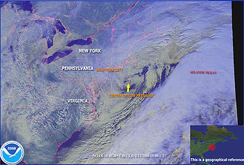 NOAA satellite image of the storm with descriptions and points of reference.
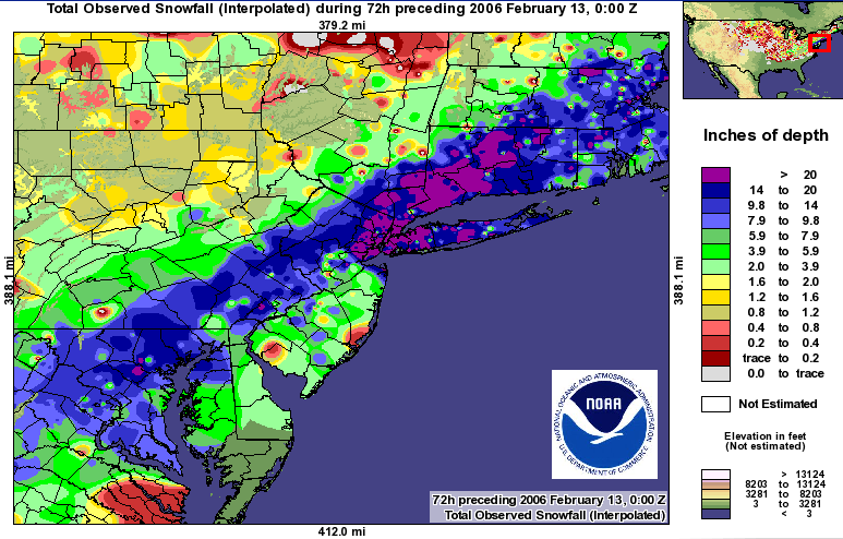
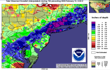 North American blizzard of 2008 snowfall accumulation for the Northeastern United States.(From the National Weather Service)
Only accumulations of 8 inches (20 cm) or greater are listed. Not all observations are listed due to space limitations; only major communities and notable reports are listed.
State City/location Amount in
inches (cm)CT Fairfield 27.8 (70.6) NJ Rahway 27.0 (68.6) CT West Hartford 27.0 (68.6) NY Manhattan (Central Park) 26.9 (68.3) CT Danbury 26.0 (66.0) NY LaGuardia Airport 25.4 (64.5) NY Bronx 24.5 (62.2) NY New Rochelle 24.5 (62.2) NY Brewster 24.0 (61.0) NY Yonkers 23.9 (60.7) CT Waterbury 23.0 (58.4) MD Randallstown 22.0 (55.9) MA Wilbraham 22.0 (55.9) CT Bradley Airport 21.9 (55.6) MD Columbia 21.3 (54.1) NJ Newark Airport 21.3 (54.1) CT East Granby 21.0 (53.3) NJ East Brunswick 21.0 (53.3) NJ Hoboken 20.7 (52.8) CT Greenwich 20.4 (51.8) NY Islip 20.0 (50.8) NY New City 20.0 (50.8) CT Norwalk 20.0 (50.8) NJ Randolph Township 20.0 (50.8) NY Woodbury (Nassau County) 20.0 (50.8) RI Foster 19.0 (48.3) NJ Ridgewood 19.0 (48.3) NJ Glen Rock 18.7 (47.5) PA Willow Grove 18.5 (47.0) RI Cumberland 18.2 (46.2) MA Cambridge 18.2 (46.2) PA Birdsboro 18.2 (46.2) MA Worcester 18.0 (45.8) MA Salem 18.0 (45.8) PA Langhorne 17.5 (44.5) MA Logan Airport 17.5 (44.5) NJ Clinton 17.4 (44.2) MA Leominster 17.4 (44.2) NJ Trenton 17.0 (43.2) NJ Edison 17.0 (43.2) MA Needham 17.0 (43.2) NY JFK Airport 16.7 (42.4) NH Nashua 16.5 (41.9) NJ Somerville 16.5 (41.9) ME East Machias 16.0 (40.6) CT New Haven 16.0 (40.6) RI Woonsocket 15.8 (40.1) VA Linden 15.5 (39.4) MA Boston Common 15.5 (39.4) CT Hartford (Downtown) 15.5 (39.4) MD Glen Burnie 15.3 (38.9) PA Allentown 15.2 (38.6) MD Baltimore 15.0 (38.0) MD Elkton 15.0 (38.0) NH Hollis 15.0 (38.0) MD Westminster 15.0 (38.0) DE Wilmington 14.4 (36.6) MD Gaithersburg 14.3 (36.3) RI Cumberland 14.0 (35.6) VA Fairfax 14.0 (35.6) MA Gloucester 14.0 (35.6) NJ Lumberton 14.0 (35.6) CT Norwich 14.0 (35.6) NH Salem 14.0 (35.6) VA Falls Church 13.5 (34.3) MA Plainville 13.5 (34.3) MD BWI Airport 13.1 (33.3) NJ Ewing 13.1 (33.3) PA Easton 13.0 (33.0) MD Hagerstown 13.0 (33.0) VA Manassas 13.0 (33.0) CT Bridgeport 12.5 (31.8) PA Philadelphia (Downtown) 12.5 (31.8) VA Haymarket 12.3 (31.2) TN Gatlinburg 12.0 (30.5) ME Kennebunk 12.0 (30.5) PA Philadelphia Airport 12.0 (30.5) MA Springfield 11.0 (27.9) NY Lynbrook 11.0 (27.9) MD Frederick 10.5 (26.7) WV Harpers Ferry 10.0 (25.4) VA Arlington 10.0 (25.4) WV Martinsburg 10.0 (25.4) ME Southwest Harbor 9.5 (24.1) RI Providence (Downtown) 9.0 (22.9) VA Winchester 8.9 (22.6) DC Washington (Capitol Hill) 8.8 (22.4) VA Dulles Airport 8.1 (20.6) Sources: National Weather Service local offices - Sterling, VA, Mount Holly, NJ, Upton, NY, Taunton, MA, Caribou, ME[dead link], Gray, ME
See also
References
- ^ http://www.hpc.ncep.noaa.gov/winter_storm_summaries/storm7/stormsum_10.html
- ^ "The Northeast Snowfall Impact Scale (NESIS)". Ncdc.noaa.gov. http://www.ncdc.noaa.gov/oa/climate/research/snow-nesis/. Retrieved 2009-08-11.
- ^ [1][dead link]
- ^ confirmed by National Weather Service Boston, MA Storm Report
- ^ "Northeast US hammered by record blizzard". http://news.yahoo.com/s/nm/20060212/ts_nm/weather_northeast_dc. Retrieved 2009-08-11.[dead link]
- ^ "CBC Nova Scotia - Shovels out in Nova Scotia". Web.archive.org. 2006-02-12. Archived from the original on 2006-09-11. http://web.archive.org/web/20060911013624/http://www.cbc.ca/ns/story/ns-snow-day20060213.html. Retrieved 2009-08-27.
- ^ "Nor'easter pummels state, but causes little damage". Archived from the original on 2006-02-22. http://web.archive.org/web/20060222195028/http://www.wfsb.com/Global/story.asp?S=4490543.
- ^ a b [2][dead link]
- ^ http://www1.whdh.com/news/articles/local/BO14188/
- ^ a b [3][dead link]
- ^ a b "NCDC: Event Details". .ncdc.noaa.gov. 2006-04-07. http://www4.ncdc.noaa.gov/cgi-win/wwcgi.dll?wwevent~ShowEvent~609792. Retrieved 2009-08-11.
- ^ "7online.com: New York City and Metro Area Traffic on WABC-TV 2/12/06". Abclocal.go.com. 2006-02-12. http://abclocal.go.com/wabc/story?section=traffic&id=3899215. Retrieved 2009-08-11.
- ^ "Northeast Digs Out From Record Snowstorm". Archived from the original on 2006-02-21. http://web.archive.org/web/20060221224329/http://news.yahoo.com/s/ap/20060213/ap_on_re_us/snowstorm.
- ^ "LIRR back on track two days after blizzard". Brotherhood of Locomotive Engineers. 2006-02-15. http://www.ble.org/pr/news/headline.asp?id=15558. Retrieved 2009-08-11.
- ^ [4][dead link]
- ^ "6abc.com: Digging Out from Snowstorm 2/13/06". Abclocal.go.com. 2006-02-13. http://abclocal.go.com/wpvi/story?section=local&id=3899900. Retrieved 2009-08-11.
- ^ [5][dead link]
External links
- 'Dangerous storm' slams Northeast, snarls travel — CNN (February 12, 2006)
- 'Winter storm hits Northeast, thousands lose power — CNN (Saturday, February 18, 2006)
- Images from the storm
Blizzards in the United States 19th century 20th century 21st century Categories:- 2006 meteorology
- 2006 natural disasters
- Blizzards in the United States
- Nor'easters
- Blizzards in Canada


Wikimedia Foundation. 2010.