- Cyclogenesis
-
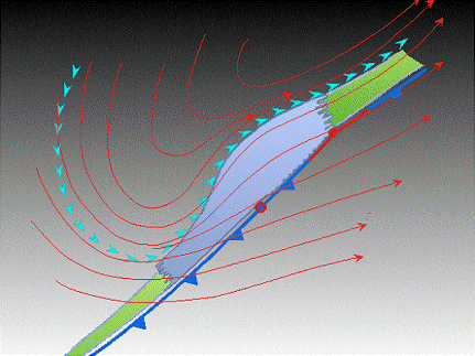
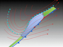 The initial frontal wave (or low pressure area) forms at the location of the red dot on the image. It is usually perpendicular (at a right angle) to the leaf-like cloud formation (baroclinic leaf) seen on satellite during the early stage of cyclogenesis. The location of the axis of the upper level jet stream is in light blue.
Cyclogenesis is the development or strengthening of cyclonic circulation in the atmosphere (a low pressure area).[1] Cyclogenesis is an umbrella term for several different processes, all of which result in the development of some sort of cyclone. It can occur at various scales, from the microscale to the synoptic scale. Extratropical cyclones form as waves along weather fronts before occluding later in their life cycle as cold core cyclones. Tropical cyclones form due to latent heat driven by significant thunderstorm activity, and are warm core. Mesocyclones form as warm core cyclones over land, and can lead to tornado formation. Waterspouts can also form from mesocyclones, but more often develop from environments of high instability and low vertical wind shear. Cyclogenesis is the opposite of cyclolysis, and has an anticyclonic (high pressure system) equivalent which deals with the formation of high pressure areas—anticyclogenesis.[2]
Contents
Meteorological scales
There are four main scales, or sizes of systems, dealt with in meteorology: the macroscale, the synoptic scale, the mesoscale, and the microscale.[3] The macroscale deals with systems with global size, such as the Madden-Julian Oscillation. Synoptic scale systems cover a portion of a continent, such as extratropical cyclones, with dimensions of 1,000-2,500 km (620-1,550 mi) across.[4] The mesoscale is the next smaller scale, and often is divided into two ranges: meso-alpha phenomena range from 200-2,000 km (125-1,243 mi) across (the realm of the tropical cyclone), while meso-beta phenomena range from 20–200 km (12-125 mi) across (the scale of the mesocyclone). The microscale is the smallest of the meteorological scales, with a size under two kilometers (1.2 mi) (the scale of tornadoes and waterspouts).[5] These horizontal dimensions are not rigid divisions but instead reflect typical sizes of phenomena having certain dynamic characteristics. For example, a system does not necessarily transition from meso-alpha to synoptic scale when its horizontal extent grows from 2,000 to 2,001 km (1,243 mi).
Extratropical cyclones
Norwegian Cyclone Model
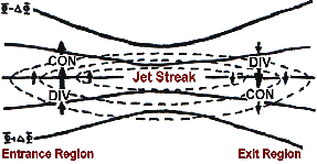
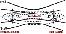 An upper level jet streak. DIV areas are regions of divergence aloft, which will lead to surface convergence and aid cyclogenesis.
The Norwegian Cyclone Model is an idealized formation model of cold-core cyclonic storms developed by Norwegian meteorologists during the First World War.[6] The main concept behind this model, relating to cyclogenesis, is that cyclones progress through a predictable evolution as they move up a frontal boundary, with the most mature cyclone near the northeast end of the front and the least mature near the tail end of the front.[7]
Precursors for development
A preexisting frontal boundary, as defined in surface weather analysis, is required for the development of a mid-latitude cyclone. The cyclonic flow begins around a disturbed section of the stationary front due to an upper level disturbance, such as a short wave or an upper-level trough,[8][9] near a favorable quadrant of the upper level jet.[10]
Modes of development
The surface low could have a variety of causes for forming. Topography can force a surface low when dense low-level high pressure system ridges in east of a north-south mountain barrier.[11] Mesoscale convective systems can spawn surface lows which are initially warm core.[12] The disturbance can grow into a wave-like formation along the front and the low will be positioned at the crest. Around the low, flow will become cyclonic, by definition. This rotational flow will push polar air equatorward west of the low via its trailing cold front, and warmer air will push poleward low via the warm front. Usually the cold front will move at a quicker pace than the warm front and “catch up” with it due to the slow erosion of higher density airmass located out ahead of the cyclone and the higher density airmass sweeping in behind the cyclone, usually resulting in a narrowing warm sector.[13] At this point an occluded front forms where the warm air mass is pushed upwards into a trough of warm air aloft, which is also known as a TROWAL (a trough of warm air aloft).[14] All developing low pressure areas share one important aspect, that of upward vertical motion within the troposphere. Such upward motions decrease the mass of local atmospheric columns of air, which lower surface pressure.[15]
Maturity
Maturity is after the time of occlusion when the storm has completed strengthening and the cyclonic flow is at its most intense.[16] Thereafter, the strength of the storm diminishes as the cyclone couples with the upper level trough or upper level low, becoming increasingly cold core. The spin-down of cyclones, also known as cyclolysis, can be understood from an energetics perspective. As occlusion occurs and the warm air mass is pushed upwards over a cold air airmass, the atmosphere becomes increasingly stable and the centre of gravity of the system lowers.[17] As the occlusion process extends further down the warm front and away from the central low, more and more of the available potential energy of the system is exhausted. This potential energy sink creates a kinetic energy source which injects a final burst of energy into the storm's motions. After this process occurs, the growth period of the cyclone, or cyclogenesis, ends, and the low begins to spin down (fill) as more air is converging into the bottom of the cyclone than is being removed out the top since upper-level divergence has decreased.
Occasionally, cyclogenesis will re-occur with occluded cyclones. When this happens a new low center will form on the triple-point (the point where the cold front, warm front, and occluded front meet). During triple-point cyclogenesis, the occluded parent low will fill as the secondary low deepens into the main weathermaker.
-
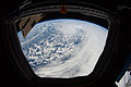
This image displays a dense cloud pattern and arcing band of convection, indicating a young, developing cyclone.
-
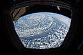
The diffuse cloud pattern in this image indicates an old, dissipating low pressure system.
-

This image illustrates the relative positions of two storm systems over the North-eastern Pacific.
Tropical cyclones
Main article: Tropical cyclogenesisTropical cyclones exist within a mesoscale alpha domain. As opposed to mid-latitude cyclogenesis, tropical cyclogenesis is driven by strong convection organised into a central core with no baroclinic zones, or fronts, extending through their center. Although the formation of tropical cyclones is the topic of extensive ongoing research and is still not fully understood, there are six main requirements for tropical cyclogenesis: sea surface temperatures that are warm enough, atmospheric instability, high humidity in lower to middle levels of the troposphere, enough Coriolis force to develop a low pressure center, a pre-existing low level focus or disturbance, and low vertical wind shear. These warm core cyclones tend to form over the oceans between 10 and 30 degrees of the equator.[18][19]
Mesocyclones
Main article: MesocycloneMesocyclones range in size from mesoscale beta to microscale. The term mesocyclone is usually reserved for mid-level rotations within severe thunderstorms,[20] and are warm core cyclones driven by latent heat of its associated thunderstorm activity.
Tornadoes form in the warm sector of extratropical cyclones where a strong upper level jet stream exists.[21] Mesocyclones are believed to form when strong changes of wind speed and/or direction with height ("wind shear") sets parts of the lower part of the atmosphere spinning in invisible tube-like rolls. The convective updraft of a thunderstorm is then thought to draw up this spinning air, tilting the rolls' orientation upward (from parallel to the ground to perpendicular) and causing the entire updraft to rotate as a vertical column.
As the updraft rotates, it may form what is known as a wall cloud. The wall cloud is a spinning layer of clouds descending from the mesocyclone. The wall cloud tends to form closer to the center of the mesocyclone. It should be noted the wall clouds do not necessarily need a mesocyclone to form and do not always rotate. As the wall cloud descends, a funnel-shaped cloud may form at its center. This is the first stage of tornado formation.[22] The presence of a mesocyclone is believed to be a key factor in the formation of the strong tornadoes associated with severe thunderstorms.
-
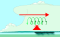
Vertical wind shear (red) sets air spinning (green).
-

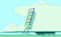
The updraft (blue) 'tips' the spinning air upright.
-
The updraft then starts rotating.
Tornadoes
Main article: TornadogenesisTornadoes exist on the microscale or low end of the mesoscale beta domain. The cycle begins when a strong thunderstorm develops a rotating mesocyclone a few miles up in the atmosphere, becoming a supercell. As rainfall in the storm increases, it drags with it an area of quickly descending air known as the rear flank downdraft (RFD). This downdraft accelerates as it approaches the ground, and drags the rotating mesocyclone towards the ground with it.[23]
As the mesocyclone approaches the ground, a visible condensation funnel appears to descend from the base of the storm, often from a rotating wall cloud. As the funnel descends, the RFD also reaches the ground, creating a gust front that can cause damage a good distance from the tornado. Usually, the funnel cloud begins causing damage on the ground (becoming a tornado) within minutes of the RFD reaching the ground.[24]
Waterspouts
Main article: WaterspoutWaterspouts exist on the microscale. While some waterspouts are strong (tornadic) like their land-based counterparts, most are much weaker and caused by different atmospheric dynamics. They normally develop in moisture-laden environments with little vertical wind shear along lines of convergence, such as land breezes, lines of frictional convergence from nearby landmasses, or surface troughs.[25] Their parent cloud can be as innocuous as a moderate cumulus, or as significant as a thunderstorm. Waterspouts normally develop as their parent clouds are in the process of development, and it is theorized that they spin up as they move up the surface boundary from the horizontal wind shear near the surface, and then stretch upwards to the cloud once the low level shear vortex aligns with a developing cumulus or thunderstorm. Weak tornadoes, known as landspouts, across eastern Colorado have been witnessed to develop in a similar manner.[26] An outbreak occurred in the Great Lakes in late September and early October 2003 along a lake effect band. September is the peak month of landspout and waterspout occurrence around Florida and for waterspout occurrence around the Great Lakes.[26][27]
Related terms
Cyclogenesis is the opposite of cyclolysis, which concerns the weakening of surface cyclones. The term has an anticyclonic (high pressure system) equivalent—Anticyclogenesis, which deals with the formation of surface high pressure systems.[2]
See also
- Atmospheric river
- European windstorm
- Extratropical cyclone
- Frontogenesis
- Hurricane dynamics and cloud microphysics
- Hybrid low
- Jet stream
- Nor'easter
- Surface weather analysis
- Rapid deepening
- Tornado
- Wind shear
References
- ^ Arctic Climatology and Meteorology (2006). "Cyclogenesis". National Snow and Ice Data Center. http://nsidc.org/arcticmet/glossary/cyclogenesis.html. Retrieved 2006-12-04.
- ^ a b Glossary of Meteorology (June 2000). "Cyclogenesis". American Meteorological Society. http://amsglossary.allenpress.com/glossary/search?p=1&query=cyclogenesis. Retrieved 2006-10-12.
- ^ Mesoscale Dynamics and Modeling Laboratory (2006-09-08). "Part I: Introduction to Mesoscale Dynamics". Archived from the original on 2006-09-08. http://web.archive.org/web/20060908102254/http://mesolab.meas.ncsu.edu/~linyl/mea713/Ch1_Note.doc. Retrieved 2006-12-04.
- ^ Arctic Climatology and Meteorology (2006). "Synoptic Scale". http://nsidc.org/arcticmet/glossary/synoptic_scale.html. Retrieved 2006-10-25.
- ^ University Corporation for Atmospheric Research. Definition of Mesoscale. Retrieved on 2006-10-25.
- ^ JetStream (2009-09-01). "Norwegian Cyclone Model". National Weather Service Southern Region Headquarters. http://www.srh.weather.gov/srh/jetstream/synoptic/cyclone.htm. Retrieved 2009-10-26.
- ^ University of Oklahoma School of Meteorology. The Norwegian Cyclone Model. Retrieved on 2006-12-04.
- ^ Glossary of Meteorology (June 2000). "Definition of Short Wave". American Meteorological Society. http://amsglossary.allenpress.com/glossary/search?p=1&query=short+wave&submit=Search. Retrieved 2009-10-26.
- ^ Glossary of Meteorology (June 2000). "Definition of Upper-Level Trough". American Meteorological Society. http://amsglossary.allenpress.com/glossary/search?id=upper-level-trough1. Retrieved 2009-10-26.
- ^ Carlyle H. Wash, Stacey H. Heikkinen, Chi-Sann Liou, and Wendell A. Nuss. A Rapid Cyclogenesis Event during GALE IOP 9. Retrieved on 2008-06-28.
- ^ COMET Program Flow Interaction With Topography
- ^ Raymond D. Menard1, and J.M. Fritsch A Mesoscale Convective Complex-Generated Inertially Stable Warm Core Vortex
- ^ The Physics Factbook Density of Air
- ^ St. Louis University What is a trowal?
- ^ Joel Norris (2005-03-19). "QG Notes". University of California, San Diego. http://meteora.ucsd.edu/~jnorris/sio217B/QG_Notes.pdf. Retrieved 2009-10-26.
- ^ Joan Von Ahn, Joe Sienkiewicz, and Greggory McFadden (April 2005). "Hurricane Force Extratropical Cyclones Observed Using QuikSCAT Near Real Time Winds". Mariner's Weather Log 49 (1). http://www.vos.noaa.gov/MWL/april_05/cyclones.shtml. Retrieved 2009-10-26.
- ^ Steve W. Woodruff (2008-06-12). "About Atmospheric Stability". Pierce College. Archived from the original on June 12, 2008. http://web.archive.org/web/20080612212855/http://www.piercecollege.edu/offices/weather/stability.html. Retrieved 2009-10-26.
- ^ Chris Landsea (2009-02-08). "Subject: A15) How do tropical cyclones form?". National Hurricane Center. http://www.aoml.noaa.gov/hrd/tcfaq/A15.html. Retrieved 2009-10-26.
- ^ Environment Canada (2003-09-18). "Tropical Cyclone Formation". Archived from the original on 2006-09-27. http://web.archive.org/web/20060927232022/http://www.ns.ec.gc.ca/weather/hurricane/hurricanes1a.html. Retrieved 2009-10-26.
- ^ Thomas Allen Jones (2007-03-11). "Mesocyclone Formation and Maintenance: A Review of Conceptual Models". Archived from the original on March 11, 2007. http://web.archive.org/web/20070311115216/http://students.ou.edu/J/Thomas.A.Jones-1/mesopaper.html. Retrieved 2009-10-26.
- ^ University Corporation for Atmospheric Research (September 2000). "How a Tornado Forms". http://www.windows.ucar.edu/tour/link=/earth/Atmosphere/tornado/formation.html. Retrieved 2009-10-26.
- ^ Michael Branick (2008-06-11). "A Comprehensive Glossary of Weather". Geographic.org. http://www.geographic.org/climate/w.html. Retrieved 2009-10-26.
- ^ Timothy P. Marshall and Erik N. Rasmussen (January 1982). "The Mesoscale Evolution of the Warren, Oklahoma Tornadoes". 12th Conference on Severe Local Storms (American Meteorological Society). http://www.stormtrack.org/library/1981/warren.htm. Retrieved 2009-10-26.
- ^ Storm Prediction Center. The Online Tornado FAQ. Retrieved on 2006-10-25.
- ^ Barry K. Choy and Scott M. Spratt. A WSR-88D Approach to Waterspout Forecasting. Retrieved on 2006-12-04. Archived October 5, 2006 at the Wayback Machine
- ^ a b Barry K. Choy and Scott M. Spratt. Using the WSR-88D to Predict East Central Florida Waterspouts. Retrieved on 2006-10-25. Archived October 5, 2006 at the Wayback Machine
- ^ "The Great Waterspout Outbreak of 2003". Mariner's Weather Log 48 (3). December 2004. http://www.vos.noaa.gov/MWL/dec_04/waterspout.shtml. Retrieved 2006-10-25.
Cyclones and Anticyclones of the world Types Annual anticyclones Polar high – Siberian High – Azores High (Bermuda/North Atlantic) – North American High (Canadian/Greenland) – South Atlantic High (St.Helena) – North Pacific High – South Pacific High – Scandinavian High – Mascarene High (Indian) – Australian High – Antarctic HighAnnual cyclones Categories:- Atmospheric dynamics
- Basic meteorological concepts and phenomena
- Midlatitude weather
-


Wikimedia Foundation. 2010.