- Sea surface temperature
-
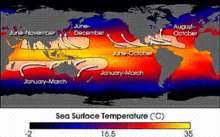
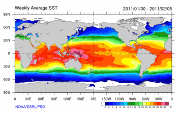 Weekly average sea surface temperature for the World Ocean during the first week of February 2011, during a period of La Niña
Sea surface temperature (SST) is the water temperature close to the oceans surface. The exact meaning of surface varies according to the measurement method used, but it is between 1 millimetre (0.04 in) and 20 metres (70 ft) below the sea surface. Air masses in the Earth's atmosphere are highly modified by sea surface temperatures within a short distance of the shore. Localized areas of heavy snow can form in bands downwind of warm water bodies within an otherwise cold air mass. Warm sea surface temperatures are known to be a cause of tropical cyclogenesis over the Earth's oceans. Tropical cyclones can also cause a cool wake, due to turbulent mixing of the upper 30 metres (100 ft) of the ocean. SST changes diurnally, like the air above it, but to a lesser degree due to its higher specific heat. There is less SST variation on breezy days than on calm days. In addition, ocean currents and the global thermohaline circulation affect average SST significantly throughout most of the world's oceans. For SSTs near the fringe of a landmass, offshore winds cause upwelling, which can cause significant cooling, but shallower waters over a continental shelf are often warmer. Onshore winds can cause a considerable warm-up even in areas where upwelling is fairly constant, such as the northwest coast of South America. Its values are important within numerical weather prediction as the SST influences the atmosphere above, such as in the formation of sea breezes and sea fog. It is also used to calibrate measurements from weather satellites.
Contents
Measurement
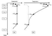
There are a variety of techniques for measuring this parameter that can potentially yield different results because different things are actually being measured. Away from the immediate sea surface, general temperature measurements are accompanied by a reference to the specific depth of measurement. This is because of significant differences encountered between measurements made at different depths, especially during the daytime when low wind speed and high sunshine conditions may lead to the formation of a warm layer at the ocean's surface and strong vertical temperature gradients (a diurnal thermocline).[1] Sea surface temperature measurements are confined to the top portion of the ocean, known as the near-surface layer.[2]
Thermometers
SST was one of the first oceanographic variables to be measured. Benjamin Franklin suspended a mercury thermometer from a ship while travelling between the United States and Europe in his survey of the Gulf stream in the late eighteenth century. SST was later measured by dipping a thermometer into a bucket of water that was manually drawn from the sea surface. The first automated technique for determining SST was accomplished by measuring the temperature of water in the intake port of large ships, which was underway by 1963. These observations have a warm bias of around 0.6 °C (1 °F) due to the heat of the engine room.[3] This bias has led to changes in the perception of global warming since 2000.[4] Fixed weather buoys measure the water temperature at a depth of 3 metres (9.8 ft). Many different drifting buoys exist around the world that vary in design, and the location of reliable temperature sensors varies. These measurements are beamed to satellites for automated and immediate data distribution.[5] A large network of coastal buoys in U.S. waters is maintained by the National Data Buoy Center (NDBC).[6] Between 1985 and 1994, an extensive array of moored and drifting buoys was deployed across the equatorial Pacific Ocean designed to help monitor and predict the El Niño phenomenon.[7]
Weather satellites
Weather satellites have been available to determine sea surface temperature information since 1967, with the first global composites created during 1970.[8] Since 1982,[9] satellites have been increasingly utilized to measure SST and have allowed its spatial and temporal variation to be viewed more fully. Satellite measurements of SST are in reasonable agreement with in situ temperature measurements.[10] The satellite measurement is made by sensing the ocean radiation in two or more wavelengths within the infrared part of the electromagnetic spectrum or other parts of the spectrum which can then be empirically related to SST.[11] These wavelengths are chosen because they are:
- within the peak of the blackbody radiation expected from the Earth,[12] and
- able to transmit adequately well through the atmosphere[13]
The satellite-measured SST provides both a synoptic view of the ocean and a high frequency of repeat views,[14] allowing the examination of basin-wide upper ocean dynamics not possible with ships or buoys. NASA's (National Aeronautic and Space Administration) Moderate Resolution Imaging Spectroradiometer (MODIS) SST satellites have been providing global SST data since 2000, available with a one-day lag. NOAA's GOES (Geostationary Orbiting Earth Satellites) satellites are geo-stationary above the Western Hemisphere which enables to them to deliver SST data on an hourly basis with only a few hours of lag time.
There are several difficulties with satellite-based absolute SST measurements. First, in infrared remote sensing methodology the radiation emanates from the top "skin" of the ocean, approximately the top 0.01 mm or less, which may not represent the bulk temperature of the upper meter of ocean due primarily to effects of solar surface heating during the daytime, reflected radiation, as well as sensible heat loss and surface evaporation. All these factors make it somewhat difficult to compare satellite data to measurements from buoys or shipboard methods, complicating ground truth efforts.[15] Secondly, the satellite cannot look through clouds, creating a cool bias in satellite-derived SSTs within cloudy areas.[1] However, passive microwave techniques can accurately measure SST and "see" through clouds.[11] Within atmospheric sounder channels on weather satellites, which peak just above the ocean's surface, knowledge of the sea surface temperature is important to their calibration.[1]
Local variation
The SST has a diurnal range, just like the Earth's atmosphere above, though to a lesser degree due to its greater specific heat.[16] On calm days, the temperature can vary by 6 °C (10 °F).[1] The temperature of the ocean at depth lags the Earth's atmosphere temperature by 15 days per 10 metres (33 ft), which means for locations like the Aral sea, temperatures near its bottom reaches a maximum in December and a minimum in May and June.[17] Near the coastline, offshore winds move the warm waters near the surface offshore, and replace them with cooler water from below in the process known as Ekman transport. This pattern increases nutrients for marine life in the region.[18] Offshore river deltas, freshwater flows over the top of the denser seawater, which allows it to heat faster due to limited vertical mixing.[19] Remotely sensed SST can be used to detect the surface temperature signature due to tropical cyclones. In general, an SST cooling is observed after the passing of a hurricane primarily as the result of mixed layer deepening and surface heat losses.[20] In the wake of several day long Saharan dust outbreaks across the adjacent northern Atlantic ocean, sea surface temperatures are reduced 0.2 C to 0.4 C (0.3 to 0.7 F).[21] Other sources of short-term SST fluctuation include extratropical cyclones, rapid influxes of glacial fresh water[22] and concentrated phytoplankton blooms[23] due to seasonal cycles or agricultural run-off.[24]
Unusually high sea surface temperatures have been implicated in some incidents involving marine animals and humans, including shark attacks such as the 2010 Sharm el-Sheikh shark attacks, as the animals need more food to sustain a higher metabolism in those temperatures.
Regional variation
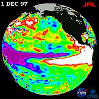 The 1997 El Niño observed by TOPEX/Poseidon. The white areas off the tropical coasts of South and North America indicate the pool of warm water.[25]
El Niño is defined by prolonged differences in Pacific Ocean surface temperatures when compared with the average value. The accepted definition is a warming or cooling of at least 0.5 °C (0.9 °F) averaged over the east-central tropical Pacific Ocean. Typically, this anomaly happens at irregular intervals of 2–7 years and lasts nine months to two years.[26] The average period length is 5 years. When this warming or cooling occurs for only seven to nine months, it is classified as El Niño/La Niña "conditions"; when it occurs for more than that period, it is classified as El Niño/La Niña "episodes".[27]
The sign of an El Niño in the sea surface temperature pattern is when warm water spreads from the west Pacific and the Indian Ocean to the east Pacific. It takes the rain with it, causing extensive drought in the western Pacific and rainfall in the normally dry eastern Pacific. El Niño's warm rush of nutrient-poor tropical water, heated by its eastward passage in the Equatorial Current, replaces the cold, nutrient-rich surface water of the Humboldt Current. When El Niño conditions last for many months, extensive ocean warming and the reduction in Easterly Trade winds limits upwelling of cold nutrient-rich deep water and its economic impact to local fishing for an international market can be serious.[28]
Importance to the Earth's atmosphere
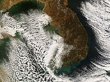
Sea surface temperature affects the behavior of the Earth's atmosphere above, so their initialization into atmospheric models is important. While sea surface temperature is important for tropical cyclogenesis, it is also important in determining the formation of sea fog and sea breezes.[1] Heat from underlying warmer waters can significantly modify an air mass over distances as short as 35 kilometres (22 mi) to 40 kilometres (25 mi).[29] For example, southwest of Northern Hemisphere extratropical cyclones, curved cyclonic flow bringing cold air across relatively warm water bodies can lead to narrow lake-effect snow (or sea effect) bands. Those bands bring strong localized precipitation, often in the form of snow, since large water bodies such as lakes efficiently store heat that results in significant temperature differences—larger than 13 °C (23 °F)—between the water surface and the air above.[30] Because of this temperature difference, warmth and moisture are transported upward, condensing into vertically-oriented clouds which produce snow showers. The temperature decrease with height and cloud depth are directly affected by both the water temperature and the large-scale environment. The stronger the temperature decrease with height, the taller the clouds get, and the greater the precipitation rate becomes.[31]
Tropical cyclones
Normally, an ocean temperature of 26.5°C (79.7°F) spanning through at least a 50-metre depth is one of the six requirements needed to maintain the special mesocyclone that is the tropical cyclone.[32] These warm waters are needed to maintain the warm core that fuels tropical systems. This value is well above 16.1 °C (60.9 °F), the long term global average surface temperature of the oceans.[33] However, this requirement can be considered only a general baseline because it assumes that the ambient atmospheric environment surrounding an area of disturbed weather presents average conditions. Tropical cyclones have intensified when SSTs were slightly below this standard temperature.
Tropical cyclones are known to form even when normal conditions are not met. For example, cooler air temperatures at a higher altitude (e.g., at the 500 hPa level, or 5.9 km) can lead to tropical cyclogenesis at lower water temperatures, as a certain lapse rate is required to force the atmosphere to be unstable enough for convection. In a moist atmosphere, this lapse rate is 6.5 °C/km, while in an atmosphere with less than 100% relative humidity, the required lapse rate is 9.8 °C/km.[34]
At the 500 hPa level, the air temperature averages -7 °C (18 °F) within the tropics, but air in the tropics is normally dry at this height, giving the air room to wet-bulb, or cool as it moistens, to a more favorable temperature that can then support convection. A wetbulb temperature at 500 hPa in a tropical atmosphere of −13.2 °C (8.2 °F) is required to initiate convection if the water temperature is 26.5 °C (79.7 °F), and this temperature requirement increases or decreases proportionally by 1 °C in the sea surface temperature for each 1 °C change at 500 hpa. Inside a cold cyclone, 500 hPa temperatures can fall as low as −30 °C (−22 °F), which can initiate convection even in the driest atmospheres. This also explains why moisture in the mid-levels of the troposphere, roughly at the 500 hPa level, is normally a requirement for development. However, when dry air is found at the same height, temperatures at 500 hPa need to be even colder as dry atmospheres require a greater lapse rate for instability than moist atmospheres.[35][36] At heights near the tropopause, the 30-year average temperature (as measured in the period encompassing 1961 through 1990) was -77 °C (-132 °F).[37] A recent example of a tropical cyclone that maintained itself over cooler waters was Epsilon of the 2005 Atlantic hurricane season.[38]
See also
- Atlantic Multidecadal Oscillation (AMO)
- Current sea level rise can occur during an increase of global or regional average SST
- Halocline refers to a salinity difference often altered by temperature-dependent factors
- Loop Current, with plots of sea temperature in the Gulf of Mexico
- Pacific Decadal Oscillation (PDO)
- Plankton, which blooms at rates dependant on sea surface temperature
- Salinity, which affects sea surface evaporation and thus temperature
- Ghrsst-pp the Group for High Resolution SST
References
- ^ a b c d e Vittorio Barale (2010). Oceanography from Space: Revisited. Springer. p. 263. ISBN 9789048186808. http://books.google.com/?id=hH2NkL_318wC&pg=PA263&dq=sea+surface+temperature+forecasting+numerical+weather+prediction+book#v=onepage&q=sea%20surface%20temperature%20forecasting%20numerical%20weather%20prediction%20book&f=false. Retrieved 2011-01-09.
- ^ Alexander Soloviev, Roger Lukas (2006). The near-surface layer of the ocean: structure, dynamics and applications. シュプリンガー・ジャパン株式会社. p. xi. ISBN 9781402040528. http://books.google.com/?id=tZary8a4HMwC&dq=ocean+layers+book&printsec=frontcover#v=onepage&q=ocean%20layers%20book&f=false. Retrieved 2011-02-10.
- ^ William J. Emery, Richard E. Thomson (2001). Data analysis methods in physical oceanography. Gulf Professional Publishing. pp. 24–25. ISBN 9780444507570. http://books.google.com/?id=A6ew-bJDIDIC&pg=PA24&dq=measurement+of+sea+surface+temperature+bucket+of+water+book#v=onepage&q=measurement%20of%20sea%20surface%20temperature%20bucket%20of%20water%20book&f=false. Retrieved 2011-01-09.
- ^ Michael Marshall (2010-11-16). "Ships and buoys made global warming look slower". New Scientist. http://www.newscientist.com/article/dn19772-ships-and-buoys-made-global-warming-look-slower-.html. Retrieved 2011-01-29.
- ^ Vittorio Barale (2010). Oceanography from Space: Revisited. Springer. pp. 237–238. ISBN 9789048186808. http://books.google.com/?id=hH2NkL_318wC&pg=PA263&dq=sea+surface+temperature+forecasting+numerical+weather+prediction+book#v=onepage&q=sea%20surface%20temperature%20forecasting%20numerical%20weather%20prediction%20book&f=false. Retrieved 2011-01-09.
- ^ Lance F. Bosart, William A. Sprigg, National Research Council (1998). The meteorological buoy and coastal marine automated network for the United States. National Academies Press. p. 11. ISBN 9780309060882.
- ^ K. A. Browning, Robert J. Gurney (1999). Global energy and water cycles. Cambridge University Press. p. 62. ISBN 9780521560573. http://books.google.com/?id=DO5K1NK_ZewC&pg=PA62&dq=1990+TOGA+ocean+buoy+network+Pacific+ocean+book#v=onepage&q&f=false. Retrieved 2011-01-09.
- ^ P. Krishna Rao, W. L. Smith, and R. Koffler (January 1972). "Global Sea-Surface Temperature Distribution Determined From an Environmental Satellite". Monthly Weather Review 100 (1): 10–14. Bibcode 1972MWRv..100...10K. doi:10.1175/1520-0493(1972)100<0010:GSTDDF>2.3.CO;2. http://docs.lib.noaa.gov/rescue/mwr/100/mwr-100-01-0010.pdf. Retrieved 2011-01-09.
- ^ National Research Council (U.S.). NII 2000 Steering Committee (1997). The unpredictable certainty: information infrastructure through 2000; white papers. National Academies. p. 2. http://books.google.com/?id=qzYrAAAAYAAJ&pg=PA2&dq=automated+sea+surface+temperature+measurement+ship+book#v=onepage&q&f=false. Retrieved 2011-01-09.
- ^ W. J. Emery, D. J. Baldwin, Peter Schlüssel, and R. W. Reynolds (2001-02-15). "Accuracy of in situ sea surface temperatures used to calibrate infrared satellite measurements". Journal of Geophysical Research 106 (C2): 2387. Bibcode 2001JGR...106.2387E. doi:10.1029/2000JC000246. http://ecco2.jpl.nasa.gov/data2/data/sst/Liming/LLi_output/References/SST_IR_insitu_a.pdf. Retrieved 2011-01-09.
- ^ a b John Maurer (October 2002). "Infrared and microwave remote sensing of sea surface temperature (SST)". University of Hawai'i. http://www2.hawaii.edu/~jmaurer/sst/. Retrieved 2011-01-09.
- ^ C. M. Kishtawal (2005-08-06). "Meteorological Satellites". Satellite Remote Sensing and GIS Applications in Agricultural Meteorology: 73. http://www.wamis.org/agm/pubs/agm8/Paper-4.pdf. Retrieved 2011-01-27.
- ^ Dr. Robert Harwood (1971-09-16). "Mapping the Atmosphere From Space". New Scientist 51 (769): 623.
- ^ David E. Alexander, Rhodes Whitmore Fairbridge (1999). Encyclopedia of environmental science. Springer. p. 510. ISBN 9780412740503. http://books.google.com/?id=Y0iX2z48qkUC&pg=PA509&lpg=PA509&dq=infrared+wavelengths+satellite+chosen+temperature+book#v=onepage&q=infrared%20wavelengths%20satellite%20chosen%20temperature%20book&f=false. Retrieved 2011-01-27.
- ^ Ian Stuart Robinson (2004). Measuring the oceans from space: the principles and methods of satellite oceanography. Springer. p. 279. ISBN 9783540426479. http://books.google.com/?id=jk1fIo51uwMC&pg=PA278&dq=measurement+of+sea+surface+temperature+book#v=onepage&q=measurement%20of%20sea%20surface%20temperature%20book&f=false. Retrieved 2011-01-09.
- ^ John Siegenthaler (2003). Modern hydronic heating for residential and light commercial buildings. Cengage Learning. p. 84. ISBN 9780766816374. http://books.google.com/?id=WdPg_1aTtr8C&pg=PA84&lpg=PA84&dq=water+higher+specific+heat+than+air+book#v=onepage&q=water%20higher%20specific%20heat%20than%20air%20book&f=false. Retrieved 2011-01-09.
- ^ Peter O. Zavialov (2005). Physical oceanography of the dying Aral Sea. シュプリンガー・ジャパン株式会社. p. 27. ISBN 9783540228912. http://books.google.com/?id=Z-LxfJVFclgC&pg=PA27&dq=sea+surface+temperature+notation+depth+book#v=onepage&q=sea%20surface%20temperature%20notation%20depth%20book&f=false. Retrieved 2011-01-09.
- ^ "Envisat watches for La Niña". BNSC via the Internet Wayback Machine. 2008-04-24. Archived from the original on 2008-04-24. http://web.archive.org/web/20080424113710/http://www.bnsc.gov.uk/content.aspx?nid=5989. Retrieved 2011-01-09.
- ^ Rainer Feistel, Günther Nausch, Norbert Wasmund (2008). State and evolution of the Baltic Sea, 1952-2005: a detailed 50-year survey of meteorology and climate, physics, chemistry, biology, and marine environment. John Wiley and Sons. p. 258. ISBN 9780471979685. http://books.google.com/?id=OeZ4e5MwRigC&pg=PA258&dq=upwelling+offshore+wind+sea+surface+temperature+book#v=onepage&q=upwelling%20offshore%20wind%20sea%20surface%20temperature%20book&f=false. Retrieved 2011-01-09.
- ^ Earth Observatory (2005). "Passing of Hurricanes Cools Entire Gulf". National Aeronautics and Space Administration. http://earthobservatory.nasa.gov/Newsroom/NewImages/images.php3?img_id=17164. Retrieved 2006-04-26.
- ^ Nidia Martínez Avellaneda (2010). The Impact of Saharan Dust on the North Atlantic Circulation. GRIN Verlag. p. 72. ISBN 9783640556397. http://books.google.com/?id=b09YTtIW3f4C&pg=PA72&dq=NASA+MODIS+sea+surface+temperature+data+lag+time#v=onepage&q&f=false. Retrieved 2011-01-27.
- ^ Boyle, Edward A.; Lloyd Keigwin (5 November 1987). "North Atlantic thermohaline circulation during the past 20,000 years linked to high-latitude surface temperature". Nature 330 (6143): 35–40. Bibcode 1987Natur.330...35B. doi:10.1038/330035a0. http://www.whoi.edu/cms/files/Boyle(1987)Nature330_35_52423.pdf. Retrieved 10 February 2011.
- ^ Beaugrand, Grégory; Keith M. Brander, J. Alistair Lindley, Sami Souissi, Philip C. Reid (11 December 2003). "Plankton effect on cod recruitment in the North Sea". Nature 426 (6967): 661–664. doi:10.1038/nature02164. PMID 14668864. http://www.nature.com/nature/journal/v426/n6967/abs/nature02164.html. Retrieved 10 February 2011.
- ^ Beman, J. Michael; Kevin R. Arrigo and Pamela A. Matson (10 March 2005). "Agricultural runoff fuels large phytoplankton blooms in vulnerable areas of the ocean". Nature 434 (7030): 211–214. Bibcode 2005Natur.434..211M. doi:10.1038/nature03370. PMID 15758999. http://www.nature.com/nature/journal/v434/n7030/abs/nature03370.html. Retrieved 10 February 2011.
- ^ "Independent NASA Satellite Measurements Confirm El Niño is Back and Strong". NASA/JPL. http://www.jpl.nasa.gov/news/releases/97/elninoup.html.
- ^ Climate Prediction Center (2005-12-19). "ENSO FAQ: How often do El Niño and La Niña typically occur?". National Centers for Environmental Prediction. http://www.cpc.noaa.gov/products/analysis_monitoring/ensostuff/ensofaq.shtml#HOWOFTEN. Retrieved 2009-07-26.
- ^ National Climatic Data Center (June 2009). "El Niño / Southern Oscillation (ENSO) June 2009". National Oceanic and Atmospheric Administration. http://www.ncdc.noaa.gov/oa/climate/research/enso/?year=2009&month=6&submitted=true. Retrieved 2009-07-26.
- ^ WW2010 (1998-04-28). "El Niño". University of Illinois at Urbana-Champaign. http://ww2010.atmos.uiuc.edu/(Gh)/guides/mtr/eln/home.rxml. Retrieved 2009-07-17.
- ^ Jun Inoue, Masayuki Kawashima, Yasushi Fujiyoshi and Masaaki Wakatsuchi (October 2005). "Aircraft Observations of Air-mass Modification Over the Sea of Okhotsk during Sea-ice Growth". Boundary-Layer Meteorology 117 (1): 111–129. Bibcode 2005BoLMe.117..111I. doi:10.1007/s10546-004-3407-y. ISSN 0006-8314. http://www.springerlink.com/content/fm26377722407422/.
- ^ B. Geerts (1998). "Lake Effect Snow.". University of Wyoming. http://www-das.uwyo.edu/~geerts/cwx/notes/chap10/lake_effect_snow.html. Retrieved 2008-12-24.
- ^ Greg Byrd (1998-06-03). "Lake Effect Snow". University Corporation for Atmospheric Research. http://www.comet.ucar.edu/class/smfaculty/byrd/sld010.htm. Retrieved 2009-07-12.
- ^ Chris Landsea (2011). "Subject: A15) How do tropical cyclones form?". Hurricane Research Division. http://www.aoml.noaa.gov/hrd/tcfaq/A15.html. Retrieved 2011-01-27.
- ^ Matt Menne (March 15, 2000). "Global Long-term Mean Land and Sea Surface Temperatures". National Climatic Data Center. http://www.ncdc.noaa.gov/cmb-faq/anomalies.php#mean. Retrieved 2006-10-19.
- ^ Kushnir, Yochanan (2000). "The Climate System". Columbia University. http://eesc.columbia.edu/courses/ees/climate/lectures/atm_phys.html. Retrieved 24 September 2010.
- ^ John M. Wallace and Peter V. Hobbs (1977). Atmospheric Science: An Introductory Survey. Academic Press, Inc. pp. 76–77.
- ^ Chris Landsea (2000). "Climate Variability of Tropical Cyclones: Past, Present and Future". Storms. Atlantic Oceanographic and Meteorological Laboratory. pp. 220–41. http://www.aoml.noaa.gov/hrd/Landsea/climvari/index.html. Retrieved 2006-10-19.
- ^ Dian J. Gaffen-Seidel, Rebecca J. Ross and James K. Angell (November 2000). "Climatological characteristics of the tropical tropopause as revealed by radiosondes". National Oceanic and Atmospheric Administration Air Resources Laboratory. Archived from the original on May 8, 2006. http://web.archive.org/web/20060508184913/http://www.aero.jussieu.fr/~sparc/SPARC2000_new/OralSess2/D_Gaffen/GaffenHtml/Abs_Gaffen.html. Retrieved 2006-10-19.
- ^ Lixion Avila (2005-12-03). "Hurricane Epsilon Discussion Eighteen". National Hurricane Center. http://www.nhc.noaa.gov/archive/2005/dis/al292005.discus.018.shtml?. Retrieved 2010-12-14.
- Dash P., Ignatov A., Kihai Y., Sapper J. (2010). "The SST Quality Monitor (SQUAM)". Journal of Atmospheric & Oceanic Technology 27 (11): 1899–1917. Bibcode 2010JAtOT..27.1899D. doi:10.1175/2010JTECHO756.1.
External links
- NASA's Physical Oceanography Distributed Active Archive Center (PO.DAAC) Provider of historic and near real time SST data from 14 satellites, spanning 1981 through yesterday
- NOAA Sea Surface Temperature (SST) Contour Charts
- Data Buoy Cooperation Panel
- SQUAM, SST Quality Monitor (A near real-time Global QC Tool for monitoring time-series stability & cross-platform consistency of satellite SST)
- iQuam, in situ SST Quality Monitor (A near real-time quality control & monitoring system for in situ SST measured by ships and buoys)
- MICROS, Monitoring of IR Clear-sky Radiances over Oceans for SST
- Sea Temperatures, Current sea temperatures around the world.
 This article incorporates public domain material from websites or documents of the National Oceanic and Atmospheric Administration.
Meteorological data and variables General Adiabatic processes · Lapse rate · Lightning · Surface solar radiation · Surface weather analysis · Visibility · Vorticity · WindCondensation Convection Temperature Dew point (Td) · Equivalent temperature (Te) · Forest fire weather index · Haines Index · Heat index · Humidex · Humidity · Potential temperature (θ) · Equivalent potential temperature (θe) · Sea surface temperature (SST) · Wet-bulb temperature · Wet-bulb potential temperature · Wind chillPressure Earth-based meteorological observation systems and weather stations By region WorldwideArgo · Global Atmosphere Watch (GAW) · Aircraft Communication Addressing and Reporting System (ACARS) · Aircraft Meteorological Data Relay (AMDAR) · Global Sea Level Observing System (GLOSS) · Deep-ocean Assessment and Reporting of Tsunamis (DART) · FluxNet Project (FluxNet)United StatesCitizens Weather Observer Program (CWOP) · Coastal-Marine Automated Network (C-MAN) · NEXRAD radar · Remote Automated Weather Station (RAWS) · Tropospheric Airborne Meteorological Data Reporting (TAMDAR)Categories:- Aquatic ecology
- Basic meteorological concepts and phenomena
- Marine meteorology and sailing
- Oceanography
- Thermodynamic cycles
Wikimedia Foundation. 2010.

