- Lake-effect snow
-
"Lake Effect" redirects here. For the American literary journal, see Lake Effect (journal).
 Lake-effect precipitation coming off Lake Erie and into Western New York, as seen by NEXRAD radar, October 12–13, 2006
Part of the Nature series on
WeatherCalendar seasons Spring · Summer
Tropical seasonsStorms Thunderstorm · Supercell
Downburst · Lightning
Tornado · Waterspout
Tropical cyclone (Hurricane)
Extratropical cyclone
Winter storm · Blizzard · Ice storm
Dust storm · Firestorm · CloudPrecipitation Drizzle · Rain · Snow · Graupel
Freezing rain · Ice pellets · HailTopics Meteorology · Climate
Weather forecasting
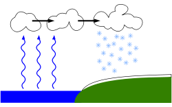
Heat wave · Air pollutionWeather portal Lake-effect snow is produced during cooler atmospheric conditions when cold winds move across long expanses of warmer lake water, providing energy and picking up water vapor which freezes and is deposited on the leeward shores. The same effect over bodies of salt water is called ocean effect snow, sea effect snow, bay effect snow, or even sound effect snow in the most blisteringly extreme cases. The effect is enhanced when the moving air mass is uplifted by the orographic influence of higher elevations on the downwind shores. This uplifting can produce narrow but very intense bands of precipitation, which deposit at a rate of many inches of snow each hour, often resulting in copious snowfall totals. The areas affected by lake-effect snow are called snowbelts. This effect occurs in many locations throughout the world but is best known in the populated areas of the Great Lakes of North America, and especially Western New York, northwestern Pennsylvania, northeastern Ohio, southwestern and central Ontario, northwestern and northcentral Indiana (mostly between Gary, IN and Elkhart, IN), and western Michigan. The Tug Hill Plateau of New York State has the most snow amounts of any non-mountainous location within the continental U.S., followed by the Upper Peninsula of Michigan, which can average over 200 inches (5 meters) of snow per year. [1]
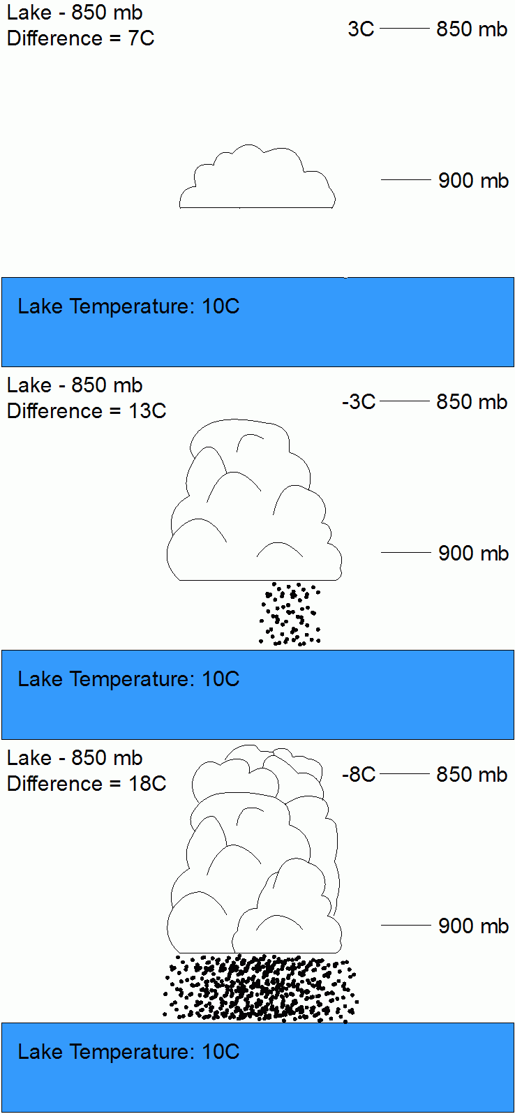
If the air temperature is not low enough to keep the precipitation frozen, it falls as lake-effect rain. For lake-effect rain or snow to form, the air moving across the lake must be significantly cooler than the surface air (which is likely to be near the temperature of the water surface). Specifically, the air temperature at an altitude where the air pressure is 850 millibars (roughly 1.5 vertical kilometres) should be 13 °C lower than the temperature of the air at the surface. Lake-effect occurring when the air at 850 millibars is much colder than the water surface can produce thundersnow, snow showers accompanied by lightning and thunder (caused by larger amounts of energy available from the increased instability).
Lake Effect season begins in mid-August, as cooler air from Canada starts to get more vigorous. The air is modified and warmed, which the precipitation type would be rain instead of snow. Also from mid-August to about mid-October, waterspouts become more common on Lake Erie due to the cooler air. Waterspouts and rains are the harbingers of Lake Effect season beginning.
Contents
Formation
There are several key elements that are required to form lake-effect precipitation and which determine its characteristics: instability, fetch, wind shear, upstream moisture, upwind lakes, synoptic (large)-scale forcing, orography/topography, and snow or ice cover.
Instability
A temperature difference of 13°C between the lake temperature and the height in the atmosphere (~1,500 meters or ~4,921 feet) at which barometric pressure dials back to 850 millibars provides for absolute instability and allows vigorous heat and moisture transportation vertically. Atmospheric lapse rate and convective depth are directly affected by both the mesoscale lake environment and the synoptic environment; a deeper convective depth with increasingly steep lapse rates and a suitable moisture level will allow for thicker, taller lake effect precipitation clouds and naturally a much greater precipitation rate.[2]
Fetch
The distance that an airmass travels over a body of water is called fetch. Because most lakes are irregular in shape, different angular degrees of travel will yield different distances; typically a fetch of at least 100 km is required to produce lake effect precipitation. Generally, the larger the fetch the more precipitation that will be produced. Larger fetches provide the boundary layer with more time to become saturated with water vapor and for heat energy to move from the water to the air. As the air mass reaches the other side of the lake, the engine of rising and cooling water vapor pans itself out in the form of condensation and falls as snow, usually within 40 kilometers of the lake.[3]
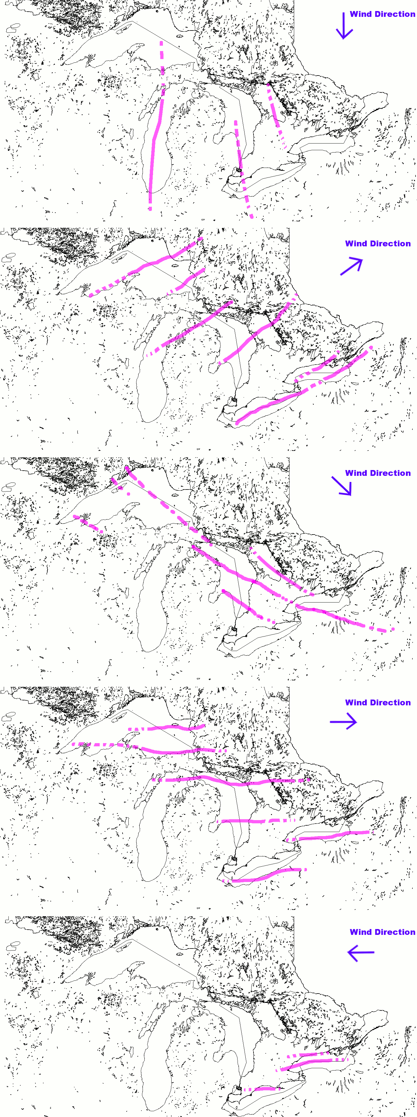
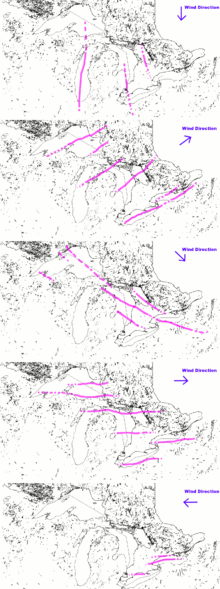 The location of common lake effect bands on the Great Lakes
Wind shear
Directional shear is one of the most important factors governing the development of squalls; environments with weak directional shear typically produce more intense squalls than those with higher shear levels. If directional shear between the surface and the height in the atmosphere at which the barometric pressure has scaled back to a reading of 700 mb is greater than 60 degrees, nothing more than flurries can be expected. If the directional shear between the body of water and the vertical height at which the pressure reads 700 mb is between 30 and 60 degrees, weak lake-effect bands are possible. In environments where the shear is less than 30 degrees, strong, well organized bands can be expected.[4]
Speed shear is less critical, but should be relatively uniform. The wind speed difference between the surface and vertical height at which the pressure reads 700 mb should be no greater than 40 knots (74 km/h) so as to prevent the upper portions of the band from shearing off. However, assuming the surface to 700mb winds are uniform, a faster overall velocity will work to transport moisture quicker from the water, and the band will travel much further inland.[4]
 Temperature difference and instability are directly related, the greater the difference the more unstable and convective the lake effect precipitation will be.
Upstream moisture
A lower upstream relative humidity will make it more difficult and time consuming for lake effect condensation, clouds and precipitation to form. The opposite is true if the upstream moisture has a high relative humidity, allowing lake effect condensation, cloud and precipitation to form more readily and in a greater quantity.[5]
Upwind lakes
Any large body of water upwind will impact lake-effect precipitation to the lee of a downwind lake by adding moisture or pre-existing lake-effect bands, which can re-intensify over the downwind lake. Upwind lakes do not always lead to an increase of precipitation downwind.[6]
Synoptic forcing
Vorticity advection aloft and large upscale ascent help increase mixing and the convective depth, while cold air advection lowers the temperature and increases instability.[7]
Orography and topography
Typically lake-effect precipitation will increase with elevation to the lee of the lake as topographic forcing squeezes out precipitation and dries out the squall much faster.[8]
Snow and ice cover
As a lake gradually freezes over, its ability to produce lake-effect precipitation decreases for two reasons. Firstly, the open ice-free liquid surface area of the lake shrinks. This reduces fetch distances. Secondly, the water temperature nears freezing, reducing overall latent heat energy available to produce squalls. To end the production of lake-effect precipitation, a complete freeze is often not necessary.[9]
Even when precipitation is not produced, cold air passing over warmer water may produce cloud cover. Fast moving mid-latitude cyclones, known as Alberta clippers, often cross the Great Lakes. After the passage of a cold front, winds tend to switch to the northwest, and a frequent pattern is for a long-lasting low-pressure area to form over the Canadian Maritimes, which may pull cold northwestern air across the Great Lakes for a week or more, commonly identified with the negative phase of the North Atlantic Oscillation (NAO). Since the prevailing winter winds tend to be colder than the water for much of the winter, the southeastern shores of the lakes are almost constantly overcast, leading to the use of the term The Great Gray Funk as a synonym for winter.[citation needed] These areas allegedly contain populations that suffer from high rates of seasonal affective disorder, a type of psychological depression thought to be caused by lack of light.[10]
Great Lakes region, U.S. Northeast
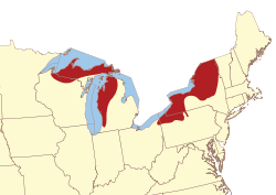 Map showing some of the lake-effect snow areas of the United States
 Buffalo, New York, after 82.3 inches (209 cm) of snow fell from December 24, 2001 to December 28, 2001
Cold winds in the winter typically prevail from the northwest in the Great Lakes region, producing the most dramatic lake-effect snowfalls on the southern and eastern shores of the Great Lakes. This lake-effect produces a significant difference between the snowfall on the southern/eastern shores and the northern and western shores of the Great Lakes.
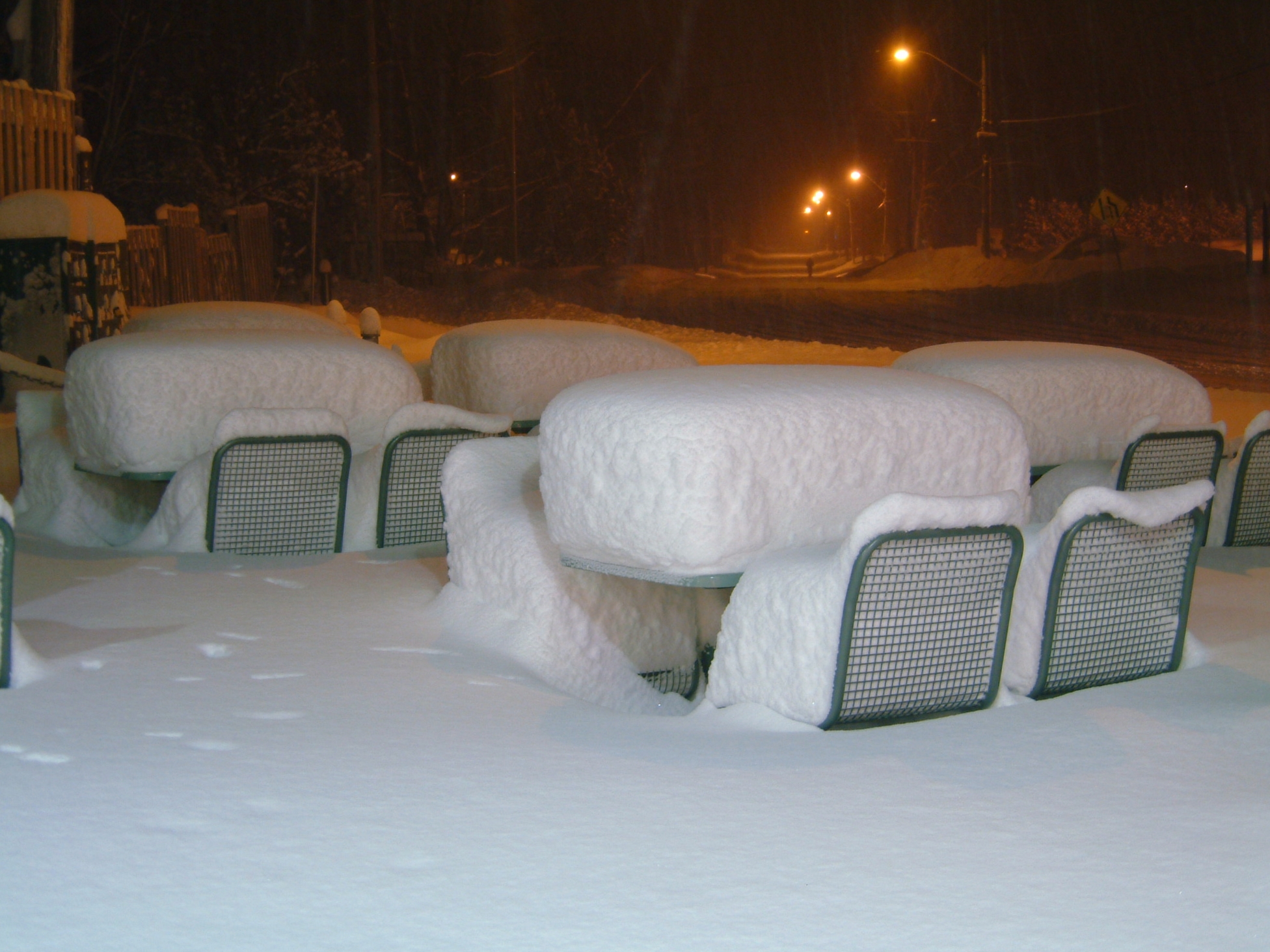
 Fulton, New York after a snowburst dropped 4-6 feet of snow over most of Oswego County between January 28–31, 2004.
Lake-effect snows on the Tug Hill Plateau (east of Lake Ontario) can frequently set daily records for snowfall in the United States. Syracuse, New York, is directly south of the Tug Hill Plateau and receives significant lake-effect snow from Lake Ontario, averaging 115.6 inches (294 cm) of snow per year, which is enough snowfall to often be considered one of the "snowiest" large cities in America.[11][12] The communities of Redfield in Oswego County and Montague and North Osceola in Lewis County, all on the Tug Hill Plateau, average over 300 inches (760 cm) of snow each winter.[13] In February, 2007, a prolonged lake-effect snow event left 141 inches (360 cm) of snow on the Tug Hill Plateau.[14]
A small amount of lake-effect snow from the Finger Lakes falls in upstate New York as well. The Appalachian Mountains and Atlantic Ocean largely shield New York City and Philadelphia from picking up any lake-effect snow; snow there tends to come from mesocyclonic storm systems mixing with cold temperatures.
 The Veteran's Day storm of November 9-14, 1996 may be the most severe early season lake effect snow (LES) storm the Great Lakes has witnessed in the past fifty years. At the height of the storm, over 160,000 customers were without power in Greater Cleveland alone, as the storm produced isolated snowfall tallies approaching 70".
Lake Erie produces a similar effect for a zone stretching from the eastern suburbs of Cleveland through Erie to Buffalo.[15] Remnants of lake-effect snows from Lake Erie have been observed to reach as far as Garrett County, Maryland.[16] Lake Erie has the distinction of being the only Great Lake capable of completely freezing over during the winter, because of its relative shallowness.[17] Once frozen, the resulting ice cover alleviates lake-effect snow downwind of the lake.
A very large snowbelt in the United States is the one in the Upper Peninsula of Michigan, near the cities of Houghton, Marquette, and Munising. These areas average 250–300 inches (630–760 cm) of snow each season.[18] For comparison, on the western shore, Duluth, Minnesota receives 78 inches (200 cm) per season.[19] Lake Superior and Lake Huron rarely freeze because of their size and depth; hence, lake-effect snow can fall continually in the Upper Peninsula and Canadian snowbelts during the winter months. Main areas of the Upper Peninsula snow belt include the Keweenaw Peninsula and Baraga, Marquette and Alger counties, where Lake Superior contributes to lake-effect snow, making them a prominent part of the midwestern snow belt. Records of 390 inches (990 cm) of snow or more have been set in many communities in this area. The Keweenaw Peninsula averages more snowfall than almost anywhere in the United States—more than anywhere east of the Mississippi River and the most of all non-mountainous regions of the continental United States. Because of the howling storms across Lake Superior, which cause dramatic amounts of precipitation, it has been said that the lake-effect snow makes the Keweenaw Peninsula the snowiest place east of the Rockies. Only one official weather station exists in this region. Located in Hancock, Michigan, this station averages well over 210 inches per year. Farther north in the peninsula, lake-effect snow can occur with any wind direction. The road commission in Keweenaw County, Michigan collects unofficial data in a community called Deleware, and it strictly follows the guidelines set forth by the National Weather Service. This station averages over 240 inches per season. Even farther north, a ski resort called Mount Bohemia receives an unofficial annual average of 273 inches. Herman, Michigan, averages 236 inches (600 cm) of snow every year. Lake-effect snow can cause blinding whiteouts in just minutes, and some storms can last days.
Western Michigan, western Northern Lower Michigan, and Northern Indiana can get heavy lake-effect snows as winds pass over Lake Michigan and deposit snows over Muskegon, Traverse City, Grand Rapids, Kalamazoo, New Carlisle, South Bend, and Elkhart, but these snows abate significantly before Lansing or Fort Wayne, Indiana. When winds become northerly, or aligned between 330 and 390 degrees, a single band of lake-effect snow may form, which extends down the length of Lake Michigan. This long fetch often produces a very intense, yet localized, area of heavy snowfall, affecting cities such as Laporte and Gary Indiana.
Lake-effect snow is uncommon in Detroit, Milwaukee, and Chicago, because the region's dominant winds are from the northwest, making them upwind from their respective Great Lakes. However, they too can see lake-effect snow during easterly or north-easterly winds. More frequently, the north side of a low-pressure system picks up more moisture over the lake as it travels west, creating a phenomenon called lake-enhanced precipitation.
Great Lakes region, Southeast Canada
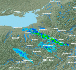
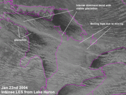 Visible Satellite image showing a large single lake-effect band from Lake Huron with vigorous vertical motion. This band produced 8 inches (20 cm) of snow in the eastern and northern suburbs of Toronto.
Because Southwestern Ontario is surrounded by water on three sides, many parts of Southwestern and Central Ontario get a large part of their winter snow from lake-effect snow. This region is notorious for the whiteouts which can suddenly reduce highway visibility on Canada's busiest highway from clear to zero. The region most commonly affected spans from Port Stanley in the west, Brantford and the Bruce Peninsula in the north, Niagara-on-the-Lake to the east, and Fort Erie to the south. The heaviest accumulations usually happen in the Bruce Peninsula, which is between Lake Huron and Georgian Bay. So long as the Great Lakes are not frozen over, the only time the Bruce Peninsula does not get lake-effect snow is when the wind is directly from the south.
Toronto and Hamilton are usually spared lake-effect squalls because they are not on the leeward side of their respective lakes during the dominant northwest winds. However, northern Toronto is affected a few times each year by lake-effect snow from Georgian Bay. Downtown Toronto and Hamilton get most of their lake-effect snow when the wind comes from the southeast or east, over Lake Ontario. Such easterly winds are usually associated with a winter cyclone passing just to the south of the Great Lakes.
When the wind is from the north, the snowbelt runs north-south from Grand Bend to Sarnia and London. Areas such as Lucan and Arkona have experienced some of the heaviest snowsqualls from Lake Huron in this region. When the wind is slightly more westerly, the snowbelt runs from Tobermory, Owen Sound, and Grand Bend to as far south and east as Arthur, Orangeville and Caledon. This snowbelt often reaches Kitchener and can affect the Halton and Peel regions of Greater Toronto. These northwesterly winds usually also bring snow southeast of Georgian Bay, which can reach beyond Lake Scugog. A westerly wind sends lake-effect streamers east from Owen Sound to Gravenhurst, Barrie, and Orillia, and may reach as far east as York Region. When the wind is from the southwest, lake-effect streamers from Lake Huron and Georgian Bay run from Noelville to Sudbury, Gravenhurst, and Algonquin Provincial Park. These snow bands can occasionally reach Quebec and Maine, while snow originating from Lake Erie, Lake Ontario and even Lake Michigan can impact southern Ontario. Easterly winds primarily affect the Niagara Peninsula. Local lake-effect snowsqualls can occasionally occur downwind of Lake Simcoe when the lake is unfrozen, usually in early winter or late fall.
 The community of Wasaga Beach after sixty centimeters of snow fell in 12 hours from a persistent lake effect band
Lake Superior has its own independent snowbelts, affecting Wawa, Sault Ste. Marie, Marathon, and Pukaskwa National Park. Thunder Bay is usually not affected by lake-effect snow, unless it is associated with a winter storm.
Elsewhere in the United States
The southern and southeastern sides of the Great Salt Lake receive significant lake-effect snow. Since the Great Salt Lake never freezes, the lake effect can influence the weather along the Wasatch Front year-round. The lake effect largely contributes to the 55–80 inches (140–200 cm) annual snowfall amounts recorded south and east of the lake, and in average snowfall reaching 500 inches (1,300 cm) in the Wasatch Range. The snow, which is often very light and dry because of the semi-arid climate, is referred to as "The Greatest Snow on Earth" in the mountains. Lake-effect snow contributes to approximately 6-8 snowfalls per year in Salt Lake City, with approximately 10% of the city's precipitation being contributed by the phenomenon.[20]
The Finger Lakes of New York are long enough for lake-effect precipitation. The Texas twin cities of Sherman and Denison are known to have experienced lake-effect snow from Lake Texoma in rare instances.
The Truckee Meadows and other parts of Northern Nevada which are normally in the rain shadow of the Sierra Nevada can, when conditions are right, have severe snowfall as a result of lake effect from Lake Tahoe. Recent severe examples of this phenomenon have occurred as recently as 2004, dumping several feet of snow in the normally dry region.
The West Coast occasionally experiences ocean-effect showers, usually in the form of rain at lower elevations south of about the mouth of the Columbia River. These occur whenever an Arctic air mass from western Canada is drawn westward out over the Pacific Ocean, typically by way of the Fraser Valley, returning shoreward around a center of low pressure. Cold air flowing southwest from the Fraser Valley can also pick up moisture over the Strait of Georgia and Strait of Juan de Fuca, then rise over the northeastern slopes of the Olympic Mountains, producing heavy, localized snow between Port Angeles and Sequim, as well as areas in Kitsap County and the Puget Sound region.[21]
Rarely, the phenomenon of gulf-effect snow has been observed along the northern coast of the Gulf of Mexico, notably during Florida's Great Blizzard of 1899.
Elsewhere in Canada
Lake Winnipeg and Lake Winnipegosis in Manitoba traditionally see lake-effect snow as early as late October, and it is common throughout early to mid November. Towards the end of November the lakes sufficiently cool and begin to freeze ending the lake effect snow. A brief period of lake-effect snow is also common near Great Bear Lake and Great Slave Lake in the Northwest Territories during early winter (usually early to mid October); however the lake-effect season for both lakes is very short. The lakes are frozen roughly 8 months of the year and as a result have very little time to warm during the summer months.
Other small lakes such as Lake Athabasca in northern Saskatchewan and Lake Nipigon in northwestern Ontario produce early season lake-effect snows. The Smallwood Reservoir, a man-made lake located in Labrador has on occasion generated lake-effect snow.
Similar phenomena
Similar snowfall can occur near large inland bays, where it is known as bay-effect snow. Bay-effect snows fall downwind of Delaware Bay, Chesapeake Bay, and Massachusetts Bay when the basic criteria are met. Ocean-effect snows are possible downwind of the Gulf Stream and the Sea of Japan.[22] Canadian Maritimes, in particular Nova Scotia and Prince Edward Island provinces, are often affected by such snow squalls when an Arctic winter airmass moves over unfrozen waters. This effect is especially intense with very warm waters of the Gulf Stream or the Sea of Japan. This also happens usually a couple of times per winter in the area near Cape Cod, and on rarer occasions along Long Island. An extreme occurrence of "ocean effect" snow occurred on January 24, 2003, when wind off the Atlantic, combined with air temperatures in the 20 °F (−7 °C), brought snow flurries to the Atlantic coast of Florida as far south as Cape Canaveral.[23]
International
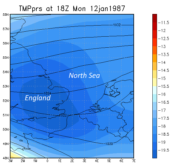
 Chart showing the lake-effect snow event of January 1987 in the UK. A continuous stream of showers deposited over a foot of snow over SE coastal regions.
Lake-effect snow occurs in other countries, near large lakes or large sea areas. One such example is the Aegean Sea in Greece, where cold northeast winds known as the boreas combined with the sea moisture can produce snowfalls over western portions of Attica province, the island of Euboea and mount Pilio area. It also occurs in the regions of the Black Sea in Georgia and Turkey or the Adriatic Sea and Italy. For example, this type of precipitation which was generated by warmer Black Sea and colder air temperature, was seen in the Istanbul area between 24 and 26 January 2010. The snowfall in the eastern regions of the Black Sea is amplified by the orographic effect of the nearby Caucasus Mountains, often resulting in snowfall of several meters, especially at higher elevations. In Northern Europe, cold, dry air masses from Russia can blow over the Baltic Sea and cause heavy snow squalls on areas of the southern and eastern coasts of Sweden.
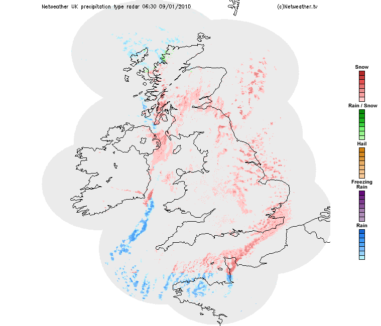
In the United Kingdom, easterly winds bringing cold continental air across the North Sea can lead to a similar phenomenon. Locally it is also known as "lake-effect snow" despite the snow coming in from the sea rather than a lake.[24] Similarly during a north-westerly wind, snow showers can form coming in from the Liverpool Bay, coming down the Cheshire gap, causing snowfall in the West Midlands - this formation resulted in the white Christmas of 2004, in the area. A similar phenomenon can affect the city of Inverness in the Scottish Highlands, where cold north east winds cause heavy snow to form in the Moray Firth; this was the case with the White Hogmanay of 2009, which caused the street party to be cancelled. Northerly and north-westerly winds can cause the effect to occur over the Irish Sea and Bristol Channel feeding snow into south-west England.
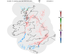
Since the North Sea is relatively warm (around 13C at the beginning of winter, typically 10C to 6C by the end), sufficiently cold air aloft can create significant snowfalls in a relatively short period of time. The best-known example occurred in January 1987, when record-breaking cold air (associated with an upper low) moved across the North Sea towards the UK. The end result was over a foot of snow for coastal areas, leading to communities being cut off for over a week. In recent years, lake-effect snow has been much lighter.
The Sea of Japan creates snowfall in the mountainous western Japanese prefectures of Niigata and Nagano, parts of which are known collectively as Snow country ("Yukiguni").
See also
- Great Salt Lake effect
- Horizontal convective rolls
- Lake effect blizzard
- Planetary boundary layer
- Sea smoke
Warnings about lake-effect snow:
United States:
Canada:
References
- ^ Climate Source: Mean Monthly and Annual Snowfall
- ^ Instability
- ^ Fetch
- ^ a b Wind Shear
- ^ Upstream Moisture
- ^ Upstream Lakes
- ^ Synoptic-Scale Forcing
- ^ Orography/Topography
- ^ Snow/Ice Cover on the Great Lakes
- ^ Weather Underground: health
- ^ Cappella, Chris: "Answers: 10 snowiest 'cities' aren't all in New York", USA Today, 3 October 2003
- ^ Kirst, Sean: "We won't buckle under the Snowbelt's blows", Post-Standard, 14 March 2005
- ^ Northern Forest Alliance. Tug Hill Plateau - New York. Retrieved on 2008-03-01.
- ^ National Climatic Data Center. Climate of 2007 - February in Historical Perspective. Retrieved on 2008-03-01.
- ^ Thomas W. Schmidlin. Climatic Summary of Snowfall and Snow Depth in the Ohio Snowbelt at Chardon. Retrieved on 2008-03-01.
- ^ Northeast Regional Climate Center. February Brings Winter Weather to the Northeast. Retrieved on 2008-03-01.
- ^ Great Lakes Information Network. 6 | Introduction to the Great Lakes. Retrieved on 2008-03-01.
- ^ Robert J. Ruhf. Lake-Effect Precipitation in Michigan. Retrieved on 2008-03-01.
- ^ University of Utah Department of Meteorology. Average Snowfall, Inches. Retrieved on 2008-03-01.
- ^ Deseret Morning News - Lake has great impacts on storm, weather. August 5, 1999.[dead link]
- ^ Mass, Cliff (2008). The Weather of the Pacific Northwest. University of Washington Press. p. 60. ISBN 9780295988474.
- ^ Lake Effect-type Phenomena in Other Regions. by COMET Retrieved on 2006-11-05.
- ^ National Weather Service Office, Melbourne, Florida.Cold Temperatures and Snow Flurries in East-Central Florida January 24, 2003. Retrieved on 2006-11-05.
- ^ USW archives [1] Retrieved on 2007-08-03.
External links
- National Weather Service Official Lake Effect Page - Based in Buffalo, NY
- Lake effect forecasting
- Lake Effect Snow. The Weather Channel Storm Encyclopedia.
- The Golden Snowball Award website
- Canadian Snowsquall storm chaser
- Digital Snow Museum
- Ice and snow measurements on lakes and surrounding land areas, Great Lakes Environmental Research Laboratory
- A BBC forecast of lake effect snow in the UK in 1991
- Before and After Pictures in Valparaiso, IN
Severe weather terminology in the United States Severe
stormsThunderstormWinter
weatherAdvisoriesHeavy snowLake-effect snowTropical
CyclonesTropical stormsHurricanesWatch · WarningFlood River floodAdvisory · Watch · WarningUrban and small stream floodAdvisoryFelt air
temperatureHeat advisory · Excessive heat watch · Excessive heat warningAdvisory · Watch · WarningMaritime
and
coastal
weatherHazardous SeasWatch · WarningFreezing SprayFreezing spray advisory · Heavy freezing spray watch · Heavy freezing spray warningStormHigh SurfAdvisory · WarningHurricane Force WindWatch · WarningMarine weather statement · Rip current statement · Lake wind advisory · Brisk wind advisory · Small craft advisory · Special marine warningWind Other Special weather statement · Significant Weather Advisory · Fire Weather Watch · Red flag warning · Fire Warning · Hazardous Weather OutlookCategories:- Snow or ice weather phenomena
- Snow
- Climate forcing agents
- Upper Peninsula of Michigan


Wikimedia Foundation. 2010.