- Horizontal convective rolls
-
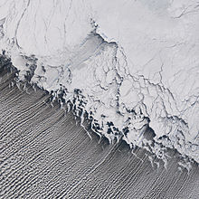
 Horizontal convective rolls producing cloud streets (lower left portion of the image) over the Bering Sea.
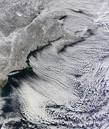
 Lines of clouds streets stretch from north-west to south-east in this natural-colour satellite view of New England.
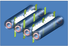
Horizontal convective rolls, also known as horizontal roll vortices or cloud streets, are long rolls of counter-rotating air that are oriented approximately parallel to the ground in the planetary boundary layer. Although horizontal convective rolls, also known as cloud streets, have been clearly seen in satellite photographs for the last 30 years, their development is poorly understood due to a lack of observational data. Research has shown these eddies to be significant to the vertical transport of momentum, heat, moisture, and air pollutants within the boundary layer.[1]
Contents
Characteristics
Horizontal convective rolls are counter-rotating vortex rolls that are nearly aligned with the mean wind of the convective boundary layer.[1] Early theory on the features predict that the vortices may be aligned up to 30° to the left for stable environments, 18° to the left for neutral environments, and nearly parallel to the mean wind for unstable environments.[2] This theory has been supported by aircraft observations from several field experiments.[3] [4]
The depth of a vortex is usually the depth of the boundary layer, which is generally on the order of 1–2 km. A vortex pair usually has a lateral to vertical dimension ratio of 3:1.[5] Experimental studies have shown that the aspect ratio (a ratio of roll wavelength to boundary layer depth) has been found to vary between 2.2:1 and 6.5:1, with an average aspect ratio of 5.7:1.[6][7] However, in some situations, the aspect ratio may be as large as 10:1. Large aspect ratios for rolls are believed to be caused by non-linear interactions at small convective scales, which are not predicted by theoretical calculations. The lifetime of a convective roll can last from 1 to 72 hours.[1]
If the environmental air is near saturation, condensation may occur in updrafts produced from the vortex rotation. The sinking motion produced between alternating pairs of rolls, combined with the updrafts, will produce cloud streets. Typical updraft and downdraft speeds are usually less than 1 m/s.[5] Gliders often use the updrafts produced by the rolls to gain altitude while flying.
Development and required environmental conditions
The exact process that leads to the formation of horizontal convective rolls is not well understood, but most formation theories involve a combination of thermal or convective instability and dynamic instability. In thermal instabilities, turbulent energy that forms the rolls is produced from buoyancy. For this condition to be satisfied, a moderate surface heat flux is necessary to produce a slightly unstable environment; however, too much heat flux will cause the environment to be too unstable, and will lead to cellular, instead of roll convection.
Turbulent energy derived from dynamic instabilities is produced from wind shear energy. Dynamic conditions favorable for roll development generally have high speed shear, and very little directional shear. Low speed shear environments generally produce cellular convection.[4] It has been suggested that dynamic instability requires an inflection point in the cross roll wind speed profile—that is, the wind speed profile is curved, reaching a maxima within the boundary layer.[2] Although inflection points are common in many wind profiles of convective roll events, some events have been observed lacking inflection points, suggesting that this is not a requirement for roll convection.[4]
The combination of convective and dynamic instability can be quantified in the ratio zi / L, where zi is the depth of the boundary layer and L is the Monin-Obukhov length. In the case of roll convection, the Monin-Obukhov length is the height at which turbulent energy production from buoyancy dominates that produced from wind shear. Roll convection is typically observed for zi / L values that are approximately greater than -5 and approximately less than -25. These conditions are most frequently observed in cold air outbreaks, and produce the combination of necessary dynamic and convective instabilities that produce roll convection. Roll convection is more frequently observed over water surfaces than land surfaces, due to the interactions of orography making the convection less distinct.[1]
References
- ^ a b c d Etling, D.; R.A. Brown (1993). "Roll Vortices in the Planetary Boundary Layer: A Review". Boundary Layer Meterology 65 (3): 215–248. Bibcode 1993BoLMe..65..215E. doi:10.1007/BF00705527.
- ^ a b Brown, R.A. (1972). "On the Inflection Point Instability of a Stratified Ekman Boundary Layer". Journal of the Atmospheric Sciences 29 (5): 851–859. Bibcode 1972JAtS...29..850B. doi:10.1175/1520-0469(1972)029<0850:OTIPIO>2.0.CO;2. ISSN 1520-0469.
- ^ LeMone, M. (1973). "The Structure and Dynamics of Horizontal Vorticities in the Planetary Boundary Layer". Journal of the Atmospheric Sciences 30 (6): 1077–1091. Bibcode 1973JAtS...30.1077L. doi:10.1175/1520-0469(1973)030<1077:TSADOH>2.0.CO;2. ISSN 1520-0469.
- ^ a b c Weckworth, T.M.; J.W. Wilson, R.M. Wakimoto, and N.A. Crook (1997). "Determining the Environmental Conditions Supporting their Existence and Characteristics". Monthly Weather Review 125 (4): 505–526. Bibcode 1997MWRv..125..505W. doi:10.1175/1520-0493(1997)125<0505:HCRDTE>2.0.CO;2. ISSN 1520-0493.
- ^ a b Stull, Roland (1988). An Introduction to Boundary Layer Meteorology. Kluwer Academic Publishers.
- ^ Kelly, R. (1982). "A Single Doppler Radar Study of Horizontal-Roll Convection in a Lake-Effect Snow Storm". Journal of the Atmospheric Sciences 21: 1816–1826.
- ^ Kuo, H. (1963). "Perturbations of Plane Couette Flow in Stratified Fluid and Origin of Cloud Sheets". Physics of Fluids 6 (2): 195–211. Bibcode 1963PhFl....6..195K. doi:10.1063/1.1706719.
External links
- Dunlop, Storm (2002) The Weather Identification Handbook Guilford, Connecticut: The Lyons Press. ISBN 1-58574-857-9
- Scorer, Verkaik (1989) Spacious Skies David & Charles ISBN 0-7153-9139-9
- "Cloud Streets Pave Hudson Bay". NASA Earth Observatory. http://earthobservatory.nasa.gov/Newsroom/NewImages/images.php3?img_id=17108. Retrieved 2006-05-01.
- "Cloud Streets Photographed over Gulf of Mexico: Gallery of Cloud Streets Images". http://www.meteorologynews.com/2009/10/29/cloud-streets-photographed-over-gulf-of-mexico/. Retrieved 2009-10-29.
Categories:
Wikimedia Foundation. 2010.

