- Low-pressure area
-
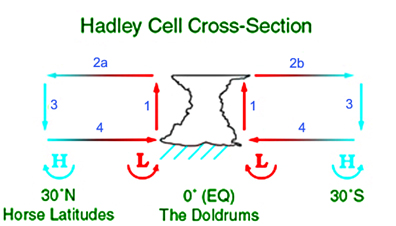
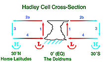 This depiction of the Hadley cell shows the process which sustains low-pressure areas. Diverging winds aloft allow for lower pressure and convergence at the Earth's surface, which leads to upward motion.
A low-pressure area, or "low", is a region where the atmospheric pressure at sea level is below that of surrounding locations. Low-pressure systems form under areas of wind divergence which occur in upper levels of the troposphere. The formation process of a low-pressure area is known as cyclogenesis. Within the field of atmospheric dynamics, areas of wind divergence aloft occur in two areas. The first area is on the east side of upper troughs which form half of a Rossby wave within the Westerlies (a trough with large wavelength which extends through the troposphere). A second area of wind divergence aloft occurs ahead of embedded shortwave troughs which are of smaller wavelength. Diverging winds aloft ahead of these troughs cause atmospheric lift within the troposphere below, which lowers surface pressures as upward motion partially counteracts the force of gravity.
Thermal lows form due to localized heating caused by greater sunshine over deserts and other land masses. Since localized areas of warm air are less dense than their surroundings, this warmer air rises which lowers atmospheric pressure near that portion of the Earth's surface. Large-scale thermal lows over continents help drive monsoon circulations. Low-pressure areas can also form due to organized thunderstorm activity over warm water. When this occurs over the tropics in concert with the Intertropical Convergence Zone, it is known as a monsoon trough. Monsoon troughs reach their northerly extent in August and their southerly extent in February. When a convective low acquires a well-defined circulation in the tropics it is termed a tropical cyclone. Tropical cyclones can form during any month of the year globally, but can occur in either the northern and southern hemisphere during November.
Atmospheric lift will also generally produce cloud cover through adiabatic cooling once the air becomes saturated as it rises, although the low-pressure area typically bring cloudy skies, which act to minimize diurnal temperature extremes. Since clouds reflect sunlight, incoming shortwave solar radiation is less which causes lower temperatures during the day. At night, the absorptive effect of clouds on outgoing longwave radiation, such as heat energy from the surface, allows for warmer diurnal low temperatures in all seasons. The stronger the area of low pressure, the stronger the winds which are experienced in its vicinity. Globally, low-pressure systems are most frequently located over the Tibetan Plateau and in the lee of the Rocky mountains. In Europe (particularly in the United Kingdom), recurring low-pressure weather systems are typically known as depressions.
Contents
Formation
Main article: CyclogenesisCyclogenesis is the development strengthening of cyclonic circulations, or low-pressure areas, within the atmosphere.[1] Cyclogenesis is the opposite of cyclolysis, and has an anticyclonic (high pressure system) equivalent which deals with the formation of high pressure areas—Anticyclogenesis.[2] Cyclogenesis is an umbrella term for several different processes, all of which result in the development of some sort of cyclone. The term cyclone is used where circular pressure systems flow in the direction of the Earth's rotation,[3][4] which normally coincides with areas of low pressure.[5][6] The largest low-pressure systems are cold-core polar cyclones and extratropical cyclones which lie on the synoptic scale. Warm-core cyclones such as tropical cyclones, mesocyclones, and polar lows lie within the smaller mesoscale. Subtropical cyclones are of intermediate size.[7][8] Cyclogenesis can occur at various scales, from the microscale to the synoptic scale. Larger scale troughs, which are also called Rossby waves, are synoptic in scale.[9] Shortwave troughs embedded within the flow around larger scale troughs are smaller in scale, or mesoscale in nature.[10] Both Rossby waves and shortwaves embedded within the flow around Rossby waves migrate equatorward of the polar cyclones located in both the Northern and Southern hemispheres.[11] All share one important aspect, that of upward vertical motion within the troposphere. Such upward motions decrease the mass of local atmospheric columns of air, which lower surface pressure.[12]
Extratropical cyclones form as waves along weather fronts due to a passing by shortwave aloft or upper level jet streak before occluding later in their life cycle as cold core cyclones.[13][14][15] [16] Polar lows are small-scale, short-lived atmospheric low-pressure systems that are found over the ocean areas poleward of the main polar front in both the Northern and Southern Hemispheres. They are part of the larger class of mesoscale weather systems. Polar lows can be difficult to detect using conventional weather reports and are a hazard to high-latitude operations, such as shipping and gas and oil platforms. They are vigorous systems that have near-surface winds of at least 17 metres per second (38 mph).[17]
Tropical cyclones form due to latent heat driven by significant thunderstorm activity, and are warm core with well-defined circulations.[18] Certain criteria need to be met for their formation. In most situations, water temperatures of at least 26.5 °C (79.7 °F) are needed down to a depth of at least 50 m (160 ft);[19] waters of this temperature cause the overlying atmosphere to be unstable enough to sustain convection and thunderstorms.[20] Another factor is rapid cooling with height, which allows the release of the heat of condensation that powers a tropical cyclone.[19] High humidity is needed, especially in the lower-to-mid troposphere; when there is a great deal of moisture in the atmosphere, conditions are more favorable for disturbances to develop.[19] Low amounts of wind shear are needed, as high shear is disruptive to the storm's circulation.[19] Lastly, a formative tropical cyclone needs a pre-existing system of disturbed weather, although without a circulation no cyclonic development will take place.[19] Mesocyclones form as warm core cyclones over land, and can lead to tornado formation.[21] Waterspouts can also form from mesocyclones, but more often develop from environments of high instability and low vertical wind shear.[22]
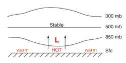 Vertical cross-section of a thermal low
In deserts, lack of ground and plant moisture that would normally provide evaporative cooling can lead to intense, rapid solar heating of the lower layers of air. The hot air is less dense than surrounding cooler air. This, combined with the rising of the hot air, results in a low-pressure area called a thermal low.[23] Monsoon circulations are caused by thermal lows which form over large areas of land and their strength is driven by how land heats quicker than the surrounding nearby ocean. This creates a steady wind blowing toward the land, bringing the moist near-surface air over the oceans with it.[24] Similar rainfall is caused by the moist ocean air being lifted upwards by mountains,[25] surface heating,[26] convergence at the surface,[27] divergence aloft, or from storm-produced outflows at the surface.[28] However the lifting occurs, the air cools due expansion in lower pressure, which in turn produces condensation. In winter, the land cools off quickly, but the ocean keeps the heat longer due to its higher specific heat. The hot air over the ocean rises, creating a low-pressure area and a breeze from land to ocean while a large area of drying high pressure is formed over the land, increased by wintertime cooling.[24] Monsoons are similar to sea and land breezes, a term usually referring to the localized, diurnal (daily) cycle of circulation near coastlines everywhere, but they are much larger in scale, stronger and seasonal.[29]
Climatology
Mid-latitudes and subtropics
 QuikSCAT image of typical extratropical cyclones over the ocean. Note the maximum winds are on the poleward side of the occluded front.See also: Arctic oscillation, Extratropical cyclone, and Thermal low
Large polar cyclones help determine the steering of systems moving through the mid-latitudes, south of the Arctic and north of the Antarctic. An index which is used to gage the magnitude of this effect in the Northern Hemisphere is the Arctic oscillation.[30] Extratropical cyclones tend to form east of climatological trough positions aloft near the east coast of continents, or west side of oceans.[31] A study of extratropical cyclones in the Southern Hemisphere shows that between the 30th and 70th parallels, there are an average of 37 cyclones in existence during any 6-hour period.[32] A separate study in the Northern Hemisphere suggests that approximately 234 significant extratropical cyclones form each winter.[33] In Europe, particularly the United Kingdom, recurring extratropical low-pressure weather systems are typically known as depressions.[34] These tend to bring wet weather throughout the year. Thermal lows also occur over continental areas across the subtropics during the summer such as the Sonoran Desert, the Mexican plateau, Sahara, South America, and Southeast Asia.[23] The lows are most commonly located over the Tibetan plateau and in the lee of the Rocky mountains.[31]
Monsoon trough
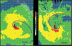
 February position of the ITCZ and monsoon trough in the Pacific Ocean, depicted by area of convergent streamlines offshore Australia and in the equatorial eastern PacificSee also: Monsoon trough
Elongated areas of low pressure form at the monsoon trough or Intertropical convergence zone as part of the Hadley cell circulation.[35] Monsoon troughing in the western Pacific reaches its zenith in latitude during the late summer when the wintertime surface ridge in the opposite hemisphere is the strongest. It can reach as far as the 40th parallel in East Asia during August and 20th parallel in Australia during February. Its poleward progression is accelerated by the onset of the summer monsoon which is characterized by the development of lower air pressure over the warmest part of the various continents.[36][37] The large-scale thermal lows over continents help create pressure gradients which drive monsoon circulations.[24] In the southern hemisphere, the monsoon trough associated with the Australian monsoon reaches its most southerly latitude in February,[38] oriented along a west-northwest/east-southeast axis. Many of the world's rainforests are associated with these climatological low-pressure systems.[39]
Tropical cyclone
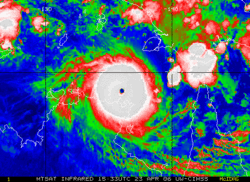 Infrared image of a powerful southern hemisphere cyclone, Monica, near peak intensitySee also: Tropical cyclone
Tropical cyclones generally need to form more than 555 km (345 mi) or poleward of the 5th parallel north and 5th parallel south, allowing the Coriolis effect to deflect winds blowing towards the low-pressure center and creating a circulation.[19] Worldwide, tropical cyclone activity peaks in late summer, when the difference between temperatures aloft and sea surface temperatures is the greatest. However, each particular basin has its own seasonal patterns. On a worldwide scale, May is the least active month while September is the most active month. November is the only month that activity in all the tropical cyclone basins possible.[40] Nearly one-third of the world's tropical cyclones form within the western Pacific ocean, making it the most active tropical cyclone basin on Earth.[41]
Associated weather
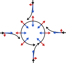 Schematic representation of flow around a low-pressure area in the Northern hemisphere. The pressure-gradient force is represented by blue arrows, the Coriolis acceleration (always perpendicular to the velocity) by red arrowsSee also: Geostrophic wind and Precipitation (meteorology)
Wind is initially accelerated from areas of high pressure to areas of low pressure.[42] This is due to density (or temperature and moisture) differences between two air masses. Since stronger high pressure systems contain cooler or drier air, the air mass is more dense and flows towards areas that are warm or moist, which are in the vicinity of low-pressure areas in advance of their associated cold fronts. The stronger the pressure difference, or pressure gradient, between a high pressure system and a low-pressure system, the stronger the wind.[43] Thus, stronger areas of low pressure are associated with stronger winds.
The Coriolis force caused by the Earth's rotation is what gives winds within low-pressure systems their counterclockwise circulation in the northern hemisphere (as the wind moves inward and is deflected right from the center of high pressure) and clockwise circulation in the southern hemisphere (as the wind moves inward and is deflected left from the center of high pressure). Friction with land slows down the wind flowing into low-pressure systems and causes wind to flow more inward, or flowing more ageostrophically, toward their centers.[43] A low-pressure area is commonly associated with inclement weather,[44] while high pressure area is associated with light winds and fair skies.[45]
See also
- East Asian monsoon
- Intertropical convergence zone
- North American Monsoon
- Surface weather analysis
- Tropical wave
- Weather map
- High-pressure area
References
- ^ Arctic Climatology and Meteorology (2009). Cyclogenesis. National Snow and Ice Data Center. Retrieved on 2009-02-21.
- ^ Glossary of Meteorology (2009). "Cyclogenesis". American Meteorological Society. http://amsglossary.allenpress.com/glossary/search?p=1&query=cyclogenesis. Retrieved 2009-02-21.
- ^ Glossary of Meteorology (June 2000). "Cyclonic circulation". American Meteorological Society. http://amsglossary.allenpress.com/glossary/search?id=cyclonic-circulation1. Retrieved 2008-09-17.
- ^ Glossary of Meteorology (June 2000). "Cyclone". American Meteorological Society. http://amsglossary.allenpress.com/glossary/search?id=cyclone1. Retrieved 2008-09-17.
- ^ BBC Weather Glossary (July 2006). "Cyclone". British Broadcasting Corporation. http://www.bbc.co.uk/weather/weatherwise/glossary/c.shtml. Retrieved 2006-10-24.
- ^ "UCAR Glossary — Cyclone". University Corporation for Atmospheric Research. http://meted.ucar.edu/satmet/goeschan/glossary.htm#c. Retrieved 2006-10-24.
- ^ Robert Hart (2003-02-18). "Cyclone Phase Analysis and Forecast: Help Page". Florida State University. http://moe.met.fsu.edu/cyclonephase/help.html. Retrieved 2006-10-03.
- ^ I. Orlanski (1975). "A rational subdivision of scales for atmospheric processes". Bulletin of the American Meteorological Society 56 (5): 527–530.
- ^ Glossary of Meteorology (June 2000). "Rossby wave". American Meteorological Society. http://amsglossary.allenpress.com/glossary/search?p=1&query=rossby+wave&submit=Search. Retrieved 2009-11-06.
- ^ Glossary of Meteorology (June 2000). "Short wave". American Meteorological Society. http://amsglossary.allenpress.com/glossary/search?id=short-wave1. Retrieved 2009-11-06.
- ^ Glossary of Meteorology (June 2000). "Polar vortex". American Meteorological Society. http://amsglossary.allenpress.com/glossary/search?id=polar-vortex1. Retrieved 2009-12-24.
- ^ Joel Norris (2005-03-19). "QG Notes". University of California, San Diego. http://meteora.ucsd.edu/~jnorris/sio217B/QG_Notes.pdf. Retrieved 2009-10-26.
- ^ Glossary of Meteorology (2009). Short Wave. American Meteorological Society. Retrieved on 2009-03-02.
- ^ Glossary of Meteorology (2009). Upper-Level Trough. American Meteorological Society. Retrieved on 2009-03-02.
- ^ Carlyle H. Wash, Stacey H. Heikkinen, Chi-Sann Liou, and Wendell A. Nuss (1989). A Rapid Cyclogenesis Event during GALE IOP 9. Monthly Weather Review pp. 234–257. Retrieved on 2008-06-28.
- ^ Shaye Johnson (2001-09-25). "The Norwegian Cyclone Model". University of Oklahoma, School of Meteorology. Archived from the original on 2006-09-01. http://web.archive.org/web/20060901163934/http://weather.ou.edu/~metr4424/Files/Norwegian_Cyclone_Model.pdf#search=%22norwegian%20cyclone%20model%22. Retrieved 2006-10-11.
- ^ E. A. Rasmussen and J. Turner (2003). Polar Lows: Mesoscale Weather Systems in the Polar Regions. Cambridge University Press. p. 612. ISBN 9780521624305.
- ^ Atlantic Oceanographic and Meteorological Laboratory, Hurricane Research Division (2004). "Frequently Asked Questions: What is an extra-tropical cyclone?". NOAA. http://www.aoml.noaa.gov/hrd/tcfaq/A7.html. Retrieved 2007-03-23.
- ^ a b c d e f Chris Landsea (2009-02-06). "Frequently Asked Questions: How do tropical cyclones form?". National Oceanic and Atmospheric Administration. http://www.aoml.noaa.gov/hrd/tcfaq/A15.html. Retrieved 2009-12-31.
- ^ Chris Landsea (2004-08-13). "Frequently Asked Questions: Why do tropical cyclones require 80 °F (27 °C) ocean temperatures to form?". National Oceanic and Atmospheric Administration. http://www.aoml.noaa.gov/hrd/tcfaq/A16.html. Retrieved 2006-07-25.
- ^ Glossary of Meteorology (2009). "Mesocyclone". American Meteorological Society. http://amsglossary.allenpress.com/glossary/search?id=mesocyclone1. Retrieved 2006-12-07.
- ^ Choy, Barry K.; Scott M. Spratt (2003-05-13). "Using the WSR-88D to Predict East Central Florida Waterspouts". NOAA. Archived from the original on 2008-06-17. http://web.archive.org/web/20080617185638/http://www.srh.noaa.gov/mlb/spoutpre.html. Retrieved 2009-12-26.
- ^ a b Glossary of Meteorology (2009). Thermal Low. American Meteorological Society. Retrieved on 2009-03-02.
- ^ a b c Dr. Louisa Watts (2009). What causes the west African monsoon? National Centre for Environmental Science. Retrieved on 2009-04-04.
- ^ Dr. Michael Pidwirny (2008). CHAPTER 8: Introduction to the Hydrosphere (e). Cloud Formation Processes. Physical Geography. Retrieved on 2009-01-01.
- ^ Bart van den Hurk and Eleanor Blyth (2008). Global maps of Local Land-Atmosphere coupling. KNMI. Retrieved on 2009-01-02.
- ^ Robert Penrose Pearce (2002). Meteorology at the Millennium. Academic Press, p. 66. ISBN 9780125480352. Retrieved on 2009-01-02.
- ^ Glossary of Meteorology (June 2000). "Gust Front". American Meteorological Society. http://amsglossary.allenpress.com/glossary/search?p=1&query=gust+front&submit=Search. Retrieved 2008-07-09.
- ^ BBC Weather (2004-09-01). "The Asian Monsoon". http://www.bbc.co.uk/weather/features/understanding/monsoon.shtml. Retrieved 2008-05-22.
- ^ Todd Mitchell (2004). Arctic Oscillation (AO) time series, 1899 - June 2002. University of Washington. Retrieved on 2009-03-02.
- ^ a b L. de la Torre, Nieto R., Noguerol M., Añel J.A., Gimeno L. (2008). A climatology based on reanalysis of baroclinic developmental regions in the extratropical northern hemisphere. Ann New York Academy of Science;vol. 1146: pp. 235-255. Retrieved on 2009-03-02.
- ^ Ian Simmonds and Kevin Keay (February 2000). "Variability of Southern Hemisphere Extratropical Cyclone Behavior, 1958–97". Journal of Climate (American Meteorological Society) 13 (3): 550–561. doi:10.1175/1520-0442(2000)013<0550:VOSHEC>2.0.CO;2#I1520-0442-13-3-550-F04. ISSN 1520-0442. http://ams.allenpress.com/perlserv/?request=get-document&doi=10.1175%2F1520-0442(2000)013%3C0550:VOSHEC%3E2.0.CO%3B2#I1520-0442-13-3-550-F04. Retrieved 2009-06-21.
- ^ S.K. Gulev, O. Zolina, and S. Grigoriev (2001). "Winter Storms in the Northern Hemisphere (1958–1999) via the Internet Wayback Machine". Climate Dynamics (Science) 17: 795–809. Bibcode 2001ClDy...17..795G. doi:10.1007/s003820000145. Archived from the original on 2007-11-14. http://web.archive.org/web/20071114023844/http://www.co2science.org/scripts/CO2ScienceB2C/articles/V4/N37/C2.jsp. Retrieved 2009-06-21.
- ^ Met Office (2009). Frontal Depressions. Retrieved on 2009-03-02.
- ^ Becca Hatheway (2008). "Hadley Cell". University Corporation for Atmospheric Research. http://www.windows.ucar.edu/tour/link=/earth/Atmosphere/hadley_cell.html. Retrieved 2009-02-16.
- ^ National Centre for Medium Range Forecasting (2004-10-23). "Chapter-II Monsoon-2004: Onset, Advancement and Circulation Features". Ministry of Earth Sciences (India). http://www.ncmrwf.gov.in/Chapter-II.pdf. Retrieved 2008-05-03.
- ^ Australian Broadcasting Corporation (1999-08-11). "Monsoon". http://www.abc.net.au/storm/monsoon/print.htm. Retrieved 2008-05-03.
- ^ U. S. Navy (1998-01-22). "1.2 Pacific Ocean Surface Streamline Pattern". http://www.nrlmry.navy.mil/~chu/chap2/se102.htm. Retrieved 2006-11-26.
- ^ Hobgood (2008). "Global Pattern of Surface Pressure and Wind". Ohio State University. http://geog-www.sbs.ohio-state.edu/courses/G230/hobgood/ASP230Lecture24.ppt. Retrieved 2009-03-08.
- ^ Atlantic Oceanographic and Meteorological Laboratory, Hurricane Research Division (2009-02-06). "Frequently Asked Questions: When is hurricane season?". National Oceanic and Atmospheric Administration. http://www.aoml.noaa.gov/hrd/tcfaq/G1.html. Retrieved 2009-12-24.
- ^ "Examining the ENSO". James B Elsner, Kam-Biu Liu. 2003-10-08. http://www.int-res.com/articles/cr2003/25/c025p043.pdf. Retrieved 2007-08-18.
- ^ BWEA (2007). Education and Careers: What is wind? British Wind Energy Association. Retrieved on 2009-02-16.
- ^ a b JetStream (2008). Origin of Wind. National Weather Service Southern Region Headquarters. Retrieved on 2009-02-16.
- ^ Glossary of Meteorology (2009). Cyclone. American Meteorological Society. Retrieved on 2009-03-02.
- ^ Jack Williams (2007). What's happening inside highs and lows. USA Today. Retrieved on 2009-02-16.
Categories:- Basic meteorological concepts and phenomena
- Types of cyclone
- Midlatitude weather
- Atmospheric dynamics
- Vortices


Wikimedia Foundation. 2010.