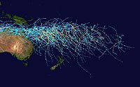
- Tropical cyclone basins
-
Part of a series on Tropical cyclones Formation and namingClimatology and tracking Tropical cyclones portal
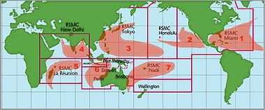

Basins and WMO Monitoring Institutions[1] Basin Responsible RSMCs and TCWCs North Atlantic National Hurricane Center (USA) North Eastern Pacific National Hurricane Center (USA), Central Pacific Hurricane Center (USA) North West Pacific Japan Meteorological Agency North Indian Indian Meteorological Department South-West Indian Météo-France South Pacific Fiji Meteorological Service
Meteorological Service of New Zealand†Australian Region Bureau of Meteorology† (Australia)
Indonesian Meteorological and Geophysical Agency
Papua New Guinea National Weather Service††: Indicates a Tropical Cyclone Warning Centre Traditionally, areas of tropical cyclone formation are divided into seven basins. These include the north Atlantic Ocean, the eastern and western parts of the northern Pacific Ocean, the southwestern Pacific, the southwestern and southeastern Indian Oceans, and the northern Indian Ocean. The western Pacific is the most active and the north Indian the least active. An average of 86 tropical cyclones of tropical storm intensity form annually worldwide, with 47 reaching hurricane/typhoon strength, and 20 becoming intense tropical cyclones (at least of Category 3 intensity).[2]
Contents
Northern Atlantic Ocean
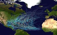
This region includes the North Atlantic Ocean, the Caribbean Sea, and the Gulf of Mexico. Tropical cyclone formation here varies widely from year to year, ranging from one to over twenty-five per year.[3] Most Atlantic tropical storms and hurricanes form between June 1 and November 30. The United States National Hurricane Center monitors the basin and issues reports, watches and warnings about tropical weather systems for the Atlantic Basin as one of the Regional Specialized Meteorological Centres for tropical cyclones as defined by the World Meteorological Organization.[4] On average, 11 named storms (of tropical storm or higher strength) occur each season, with an average of 6 becoming hurricanes and 2 becoming major hurricanes. The climatological peak of activity is around September 10 each season.[5]
The United States Atlantic coast, Mexico, Central America, the Caribbean Islands, and Bermuda are frequently affected by storms in this basin. Venezuela, the south-east of Canada and Atlantic Macaronesian islands also are occasionally affected. Many of the more intense Atlantic storms are Cape Verde-type hurricanes, which form off the west coast of Africa near the Cape Verde islands. Occasionally, a hurricane that evolves into an extratropical cyclone can reach western Europe, including Hurricane Gordon, which spread high winds across Spain and the British Isles in September 2006.[6] Hurricane Vince, which made landfall on the southwestern coast of Spain as a tropical depression in October 2005, is the only known system to impact mainland Europe as a tropical cyclone.[7]
Northeast Pacific Ocean
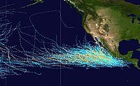 Tracks of all tropical cyclones in the northern Pacific Ocean east of the International Date Line between 1980 and 2005; the vertical line through the center separates the Central Pacific basin (under the Central Pacific Hurricane Center's watch) from the Northeastern Pacific basin (under the National Hurricane Center's area of responsibility).
The Northeastern Pacific is the second most active basin and has the highest number of storms per unit area. The hurricane season runs between May 15 and November 30 each year, and encompasses the vast majority of tropical cyclone activity in the region.[8] In the 1971–2005 period, there were an average of 15–16 tropical storms, 9 hurricanes, and 4–5 major hurricanes (storms of Category 3 intensity or greater) annually in the basin.[8]
Storms that form here often affect western Mexico, and less commonly the Continental United States (in particular California), or northern Central America. No hurricane included in the modern database has made landfall in California; however, historical records from 1858 speak of a storm that brought San Diego winds over 75 mph/65 kts (marginal hurricane force), though it is not known if the storm actually made landfall.[9] Tropical storms in 1939, 1976 and 1997 brought gale-force winds to California.[9]
The Central Pacific Hurricane Center's area of responsibility (AOR) begins at the boundary with the National Hurricane Center' AOR (at 140 °W), and ends at the International Date Line, where the Northwestern Pacific begins.[1] The hurricane season in the North Central Pacific runs annually from June 1 to November 30;[10] The Central Pacific Hurricane Center monitors the storms that develop or move into the defined area of responsibility.[1] The CPHC previously tasked with monitoring tropical activity in the basin was originally known as the Joint Hurricane Warning Center; today it is called the Joint Typhoon Warning Center.
Central Pacific hurricanes are rare and on average 4 to 5 storms form or move in this area annually.[10] As there are no large contiguous landmasses in the basin, direct hits and landfalls are rare; however, they occur occasionally, as with Hurricane Iniki in 1992, which made landfall on Hawaii,[11] and Hurricane Ioke in 2006, which made a direct hit on Johnston Atoll.[12]
Northwestern Pacific Ocean
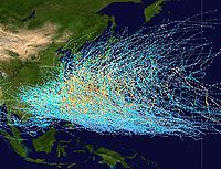 Tracks of all tropical cyclones in the northernwestern Pacific Ocean between 1980 and 2005. The vertical line to the right is the International Date Line.
The Northwest Pacific Ocean is the most active basin on the planet. Annually, an average of 25.7 tropical cyclones in the basin acquire tropical storm strength or greater; also, an average of 16 typhoons occurred each year during the 1968–1989 period.[3] The basin occupies all the territory north of the equator and west of the International Date Line, including the South China Sea.[1] The basin sees activity year-round; however, tropical activity is at its minimum in February and March.[13]
Tropical storms in this region often affect China, Japan, South Korea, Hong Kong, the Philippines, and Taiwan, as well as countries in Southeast Asia such as Vietnam and parts of Indonesia, plus numerous Oceanian islands. This is by far the most active basin, accounting for one-third of all tropical cyclone activity. The coast of China sees the most landfalling tropical cyclones worldwide.[14] The Philippines archipelago receives an average of 6-7 tropical cyclone landfalls per year.[15]
North Indian Ocean
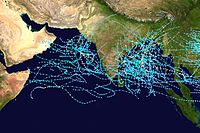
This basin is divided into two areas by India: the Bay of Bengal and the Arabian Sea, with the Bay of Bengal dominating (5 to 6 times more activity). Still, this basin is the most inactive worldwide, with only 4 to 6 storms per year. This basin's season has a double peak: one in April and May, before the onset of the monsoon, and another in October and November, just after.[16] Although it is an inactive basin, the deadliest tropical cyclones in the world have formed here, including the 1970 Bhola cyclone, which killed 500,000 people. Nations affected include India, Bangladesh, Sri Lanka, Thailand, Myanmar, and Pakistan. Rarely do tropical cyclones that form in this basin affect the Arabian Peninsula or Somalia; however, Cyclone Gonu caused heavy damage in Oman on the peninsula in 2007.
South-West Indian Ocean
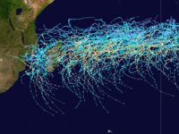
Despite nearly a half century of historical data, research at Reunion Island into tropical cyclones has been a priority only since 1999, when Météo-France began assigning additional personnel for research purposes.[17] Cyclones forming in this area can affect Madagascar, Mozambique, Mauritius, Réunion, Comoros, Tanzania, and Kenya.[17] An average of about ten tropical cyclones form in this basin per year, and this basin, annually, is the deadliest worldwide, with up to 80 deaths in every season.[3]
Australian region
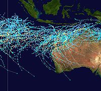
Tropical activity in this region affects Australia and Indonesia. According to the Australian Bureau of Meteorology, the most frequently hit portion of Australia is between Exmouth and Broome in Western Australia.[18] The basin sees an average of about seven cyclones each year, although more can form or come in from other basins, like the South Pacific.[3] Only about five cyclones reach Category 5 each year.[19][20] The tropical cyclone Cyclone Vance in 1999 produced the highest recorded speed winds in an Australian town or city at around 267 km/h.[21]
South Pacific Ocean
The South Pacific Ocean basin starts at 160°E and extends to 120°W with cyclones developing in it officially monitored by Fiji and New Zealand's Meteorological Services. Tropical Cyclones that develop within this basin generally affect countries to the west of the dateline, though during El Nino's cyclones have been known to develop to the east of the dateline near French Polynesia. On average the basin sees nine tropical cyclones annually with about 1/2 of them becoming severe tropical cyclones.
Other areas
South Atlantic Ocean
Cyclones form rarely or never in other tropical ocean areas, which are not formally considered tropical cyclone basins. Tropical depressions and tropical storms occur occasionally in the South Atlantic, and the only full-blown tropical cyclones on record were 2004's Cyclone Catarina, which made landfall in Brazil, 2010's Tropical Storm Anita, which formed off the coast of Rio Grande do Sul, and 2011's Subtropical Storm Arani, which formed off Brazil.
Mediterranean Sea
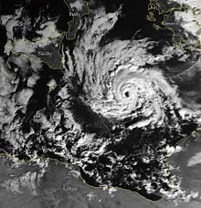
On rare occasions, tropical-like systems occur over the Mediterranean Sea. These systems are a subject of some debate within meteorological circles whether they closely fit the definition of tropical cyclones, subtropical cyclones, or polar lows. Their origins are typically non-tropical, and develop over open waters under strong, initially cold-core cyclones, similar to subtropical cyclones in the Atlantic Basin.[22] Sea surface temperatures in late-August and early-September are quite high over the basin (+24/+28°C), though research indicates water temperatures of 20 °C/68 °F are normally required for development.[23]
Meteorological literature documents that such systems occurred in September 1947, September 1969, January 1982, September 1983, January 1995 and November 2011 (the latter officially classified as Tropical Storm 01M).[24][25] The 1995 system developed a well-defined eye, and a ship recorded 85 mph (140 km/h) winds, along with an atmospheric pressure of 975 mbar. Although it had the structure of a tropical cyclone, it occurred over 61 °F (16 °C) water temperatures, suggesting it could have been a polar low.[26]
See also
References
- ^ a b c d Atlantic Oceanographic and Meteorological Laboratory, Hurricane Research Division. "Frequently Asked Questions: What regions around the globe have tropical cyclones and who is responsible for forecasting there?". NOAA. http://www.aoml.noaa.gov/hrd/tcfaq/F1.html. Retrieved 2006-07-25.
- ^ Chris Landsea. "Climate Variability table — Tropical Cyclones". Atlantic Oceanographic and Meteorological Laboratory, National Oceanic and Atmospheric Administration. http://www.aoml.noaa.gov/hrd/Landsea/climvari/table.html. Retrieved 2006-10-19.
- ^ a b c d Atlantic Oceanographic and Meteorological Laboratory, Hurricane Research Division. "Frequently Asked Questions: What are the average, most, and least tropical cyclones occurring in each basin?". NOAA. http://www.aoml.noaa.gov/hrd/tcfaq/E10.html. Retrieved 2006-11-30.
- ^ Climate Prediction Center (2006-08-08). "Background Information: The North Atlantic Hurricane Season". National Oceanic and Atmospheric Administration. http://www.cpc.ncep.noaa.gov/products/outlooks/background_information.shtml. Retrieved 2007-03-14.
- ^ National Hurricane Center (2007-03-08). "Tropical Cyclone Climatology". National Oceanic and Atmospheric Administration. http://www.nhc.noaa.gov/pastprofile.shtml. Retrieved 2007-03-14.
- ^ Blake, Eric S. (November 14, 2006). "Tropical Cyclone Report: Hurricane Gordon: 10-20 September 2006" (PDF). National Hurricane Center. http://www.nhc.noaa.gov/pdf/TCR-AL072006_Gordon.pdf. Retrieved 2006-11-29.
- ^ Franklin, James L. (February 22, 2006). "Tropical Cyclone Report: Hurricane Vince: 8-11 October 2005" (PDF). National Hurricane Center. http://www.nhc.noaa.gov/pdf/TCR-AL242005_Vince.pdf. Retrieved 2006-11-29.
- ^ a b Climate Prediction Center, NOAA (2006-05-22). "Background Information: East Pacific Hurricane Season". National Oceanic and Atmospheric Administration. http://www.cpc.ncep.noaa.gov/products/Epac_hurr/background_information.html. Retrieved 2006-05-24.
- ^ a b Chenoweth, Michael and Christopher Landsea (November 2004). "The San Diego Hurricane of 2 October 1858" (PDF). American Meteorological Society. http://www.aoml.noaa.gov/hrd/Landsea/chenowethlandsea.pdf. Retrieved 2006-12-01.
- ^ a b Central Pacific Hurricane Center. "CPHC Climatology". National Oceanic and Atmospheric Administration. http://www.prh.noaa.gov/cphc/pages/climatology.php. Retrieved 2007-03-02.
- ^ Central Pacific Hurricane Center (1992). "The 1992 Central Pacific Tropical Cyclone Season". http://www.prh.noaa.gov/cphc/summaries/1992.php#Iniki. Retrieved 2007-03-02.
- ^ Leone, Diana (2006-08-23). "Hawaiian-named storm hits Johnston Isle". Star Bulletin. http://archives.starbulletin.com/2006/08/23/news/story01.html. Retrieved 2007-03-02.
- ^ Atlantic Oceanographic and Meteorological Laboratory, Hurricane Research Division. "Frequently Asked Questions: When is hurricane season?". NOAA. http://www.aoml.noaa.gov/hrd/tcfaq/G1.html. Retrieved 2006-07-25.
- ^ Weyman, James C. and Linda J. Anderson-Berry (December 2002). "Societal Impact of Tropical Cyclones". Fifth International Workshop on Tropical Cyclones. Atlantic Oceanographic and Meteorological Laboratory. http://www.aoml.noaa.gov/hrd/iwtc/AndersonBerry5-1.html. Retrieved 2006-04-26.
- ^ Shoemaker, Daniel N. (1991). "Characteristics of Tropical Cyclones Affecting the Philippine Islands" (PDF). Joint Typhoon Warning Center. http://www.nrlmry.navy.mil/forecaster_handbooks/Philippines2/Forecasters%20Handbook%20for%20the%20Philippine%20Islands%20and%20Surrounding%20Waters%20Appendix%20B.pdf. Retrieved 2006-11-29.
- ^ Joint Typhoon Warning Center (2004). "1.2: North Indian Tropical Cyclones". 2003 Annual Tropical Cyclone Report. http://www.usno.navy.mil/NOOC/nmfc-ph/RSS/jtwc/atcr/2003atcr/chapter1/chapter1_2.html. Retrieved 2006-11-29.
- ^ a b World Meteorological Organization. "Tropical Cyclone RSMC / South-West Indian Ocean" (
 DOC). Archived from the original on 2006-09-08. http://web.archive.org/web/20060908114704/http://www.wmo.ch/web/www/TCP/RSMC-TCWC/RSMC-LaReunion.doc. Retrieved 2006-11-29.
 - ^ "Tropical Cyclones in Western Australia – Climatology". Bureau of Meteorology. http://www.bom.gov.au/weather/wa/cyclone/about/climatology.shtml. Retrieved 2006-08-08.
- ^ "BoM — Severe Weather Event". Bureau of Meteorology. http://www.bom.gov.au/announcements/sevwx/. Retrieved 2008-10-19.
- ^ "Tropical Cyclone Trends". Bureau of Meteorology. http://www.bom.gov.au/weather/cyclone/tc-trends.shtml. Retrieved 2008-10-19.
- ^ "BoM — Cyclone Vance produces highest recorded wind speed in Australia". Bureau of Meteorology. http://www.bom.gov.au/announcements/media_releases/wa/waro_19990323.shtml. Retrieved 2008-10-19.
- ^ ADGEO - redirect
- ^ Microsoft Word - EGS2000-Plinius-II-Meneguzzo.doc
- ^ Erik A. Rasmussen and John Turner (2003). Polar lows: mesoscale weather systems in the polar regions. Cambridge University Press. pp. 214–219. ISBN 9780521624305. http://books.google.com/?id=-tBa1DWYoDIC&pg=PA227&dq=cold+core+low+book#v=onepage&q=cold%20core%20low%20book&f=false. Retrieved 2011-01-27.
- ^ Schwartz (2011-11-07). "TXMM21 KNES 071819". Satellite Services Division. National Oceanic and Atmospheric Administration. http://www.webcitation.org/631VtNFBP. Retrieved 2011-11-07.
- ^ DR. JACK BEVEN'S IMAGES OF THE MEDITERRANEAN 'HURRICANE' (1995)
Categories:- Tropical cyclones
- Tropical cyclone meteorology
Wikimedia Foundation. 2010.

