- Equator
-
For other uses, see Equator (disambiguation).
 0°Equator
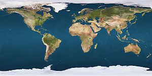
 Nations that touch the Equator (red) or the Prime Meridian (blue)
An equator is the intersection of a sphere's surface with the plane perpendicular to the sphere's axis of rotation and containing the sphere's center of mass.
The Equator refers to the Earth's equator and is an imaginary line on the Earth's surface equidistant from the North Pole and South Pole, dividing the Earth into the Northern Hemisphere and Southern Hemisphere. Other planets and spherical astronomical bodies have equators similarly defined.
Contents
Geodesy of the Equator
 Road sign marking the Equator near Nanyuki, Kenya
The latitude of the Equator is 0° (zero degrees). The length of Earth's equator is about 40,030.2 kilometres (24,873.6 mi). To calculate the actual length of the Equator would require taking into consideration that the Equator goes up and down various mountains and hills in South America, in Africa, and on various islands. The Equator is one of the five notable circles of latitude on Earth, with the others being the two Polar Circles and the two Tropical Circles: the Tropic of Cancer and the Tropic of Capricorn. The Equator is the only line of latitude which is also a great circle. The imaginary circle obtained when the Earth's equator is projected onto the sky is called the celestial equator.
The Sun, in its seasonal apparent movement across the sky, passes directly over the Equator twice each year, at the March and September equinoxes. At the Equator, the rays of the sun are perpendicular to the surface of the earth on these dates.
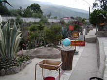
 The Equator marked as it crosses Ilhéu das Rolas, in São Tomé and Príncipe
Places on the Equator experience the quickest rates of sunrise and sunset in the world. They are also the only places in the world where the sun can go directly from the zenith to the nadir and from the nadir to the zenith. Such places also have a theoretical constant 12 hours of day and night throughout the year, though in practice there are variations of a few minutes due to the effects of atmospheric refraction and because sunrise and sunset are measured from the time that the edge of the Sun's disk is on the horizon, rather than the center of the disk.
The Earth bulges slightly at the Equator. It has an average diameter of 12,750 kilometres (7,922 mi), but at the Equator the diameter is approximately 43 kilometres (27 mi) greater than the polar diameter.
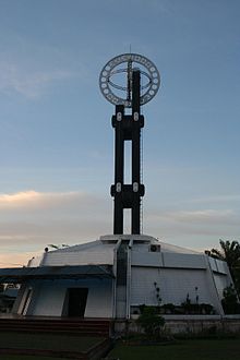 A monument marking the Equator near the town of Pontianak, Indonesia
Locations near the Equator are theoretically good sites for spaceports, such as the Guiana Space Centre in Kourou, French Guiana, as they are already moving faster than any other point on the Earth due to the Earth's rotation, and the added velocity reduces the amount of fuel needed to launch spacecraft. Spacecraft launched in this manner must launch to the east, southeast, or northeast to take advantage of this effect.
For high precision work, the Equator is not quite as fixed as the above discussion implies. The true equatorial plane must always be perpendicular to the Earth's spin axis. Although this axis is relatively stable, its position drifts about 9.0 metres (30 ft) north-south over the course of a year. Thus, the true equator moves slightly, but this effect is only relevant in extremely precise geophysical measurements.
Equatorial seasons and climate
Near the Equator there is little distinction between summer, winter, autumn, or spring. The temperatures there are usually high year-round—with the distinct exception of parts of the Equator that cross high mountains in South America and in Africa. (See Andes Mountains and Mt. Kilimanjaro.) The temperature at the Equator can also plummet during the extensive rainstorms in many locations. In many tropical regions people identify two seasons: the wet season and the dry season. However, many places close to the Equator are on the oceans or rainy throughout the year. The seasons can vary depending on a variety of factors including elevation and proximity to an ocean. These oceanic, rainy, and mountainous locations mean that the equatorial climate is not the hottest in the world.
The surface of the Earth at the Equator lies mostly on three of the oceans: the Pacific Ocean, the Atlantic Ocean, and the Indian Ocean. The highest point on the Equator is at the elevation of 4,690 metres (15,387 ft), at 0°0′0″N 77°59′31″W / 0°N 77.99194°W, found on the southern slopes of Volcán Cayambe [summit 5,790 metres (18,996 ft)] in Ecuador. This place is a short distance above the snow line, and this immediate vicinity forms the only section of the Equator where snow lies on the ground year-round.
Equatorial countries and territories
The Equator traverses the land and/or territorial waters of 14 countries. Starting at the Prime Meridian and heading eastwards, the Equator passes through:
Despite its name, no part of Equatorial Guinea's territory lies on the Equator. However, its island of Annobón is 155 kilometres (100 mi) south of the Equator, and the rest of the country lies to the north.
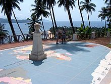
 Monuments and signs along the line of the GPS-calculated Equator at Museo de Sitio Intiñan, Mitad del Mundo, Ecuador. In the front there is a device for "demonstrating" the notion that water circles in different directions in different hemispheres.
Crossing the Equator
Main article: Line-crossing ceremonyCertain navies, such as the Royal Navy and the US Navy, have a tradition of holding ceremonies on board ship to mark sailors' first crossing of the Equator. These rites of initiation have in the past been notorious for their brutality. Milder line-crossing ceremonies, typically featuring King Neptune, are also held for passengers' entertainment on some civilian ocean liners and cruise ships.
Exact length of the Equator
In two widely-used geodetic standards, the Equator is modeled as a circle whose radius is a whole number of metres. In 1976 the IAU standardized this radius as 6,378,140 metres (20,925,656 ft), subsequently refined by the IUGG to 6,378,137 metres (20,925,646 ft) and adopted in WGS-84, though the yet more recent IAU-2000 has retained the old IAU-1976 value. In either case, the length of the Equator is by definition exactly 2π times the given standard, which to the nearest millimeter is 40,075,016.686 metres (131,479,713.54 ft) in WGS-84 and 40,075,035.535 metres (131,479,775.38 ft) in IAU-1976 and IAU-2000.[1]
The geographical mile is defined as one arc minute of the Equator, and therefore has different values depending on which standard equator is used, namely 1,855.3248 metres (6,087.024 ft) or 1,855.3257 metres (6,087.027 ft) for respectively WGS-84 and IAU-2000, a difference of nearly a millimeter.
The earth is standardly modeled as a sphere flattened 0.336% along its axis. This makes the Equator 0.16% longer than a meridian (as a great circle passing through the two poles). The IUGG standard meridian is, to the nearest millimeter, 40,007,862.917 metres (131,259,392.77 ft), one arc minute of which is 1,852.216 metres (6,076.82 ft), explaining the SI standardization of the nautical mile as 1,852 metres (6,076 ft), more than 3 metres (10 ft) short of the geographical mile.
Climate
The zone of the Equator has a tropical rainforest climate, also known as an equatorial climate. Usually, its average annual temperature is around 30 °C (86 °F) during the day and 23 °C (73 °F) at night. Rainfall is very high, usually from 2,500 to 3,500 mm per year. Average precipitation days are around 200 per year and average sunshine hours are around 2000 per year.
Climate data for Macapá, Brazil in South America Month Jan Feb Mar Apr May Jun Jul Aug Sep Oct Nov Dec Year Average high °C (°F) 29.7
(85.5)29.2
(84.6)29.3
(84.7)29.5
(85.1)30.0
(86.0)30.3
(86.5)30.6
(87.1)31.5
(88.7)32.1
(89.8)32.6
(90.7)32.3
(90.1)31.4
(88.5)30.71 Daily mean °C (°F) 26.4
(79.5)26.2
(79.2)26.3
(79.3)26.5
(79.7)26.8
(80.2)26.8
(80.2)26.8
(80.2)27.4
(81.3)27.8
(82.0)28.1
(82.6)27.9
(82.2)27.4
(81.3)27.03 Average low °C (°F) 23.0
(73.4)23.1
(73.6)23.2
(73.8)23.5
(74.3)23.5
(74.3)23.2
(73.8)22.9
(73.2)23.3
(73.9)23.4
(74.1)23.5
(74.3)23.5
(74.3)23.4
(74.1)23.29 Precipitation mm (inches) 299.6
(11.795)347.0
(13.661)407.2
(16.031)384.3
(15.13)351.5
(13.839)220.1
(8.665)184.8
(7.276)98.00
(3.8583)42.60
(1.6772)35.50
(1.3976)58.40
(2.2992)142.5
(5.61)2,571.5
(101.24)Avg. precipitation days (≥ 0.1 mm) 23 22 24 24 25 22 19 13 6 5 6 14 203 Sunshine hours 148.8 113.1 108.5 114.0 151.9 189.0 226.3 272.8 273.0 282.1 252.0 204.6 2,336.1 Source: World Meteorological Organization (UN)[2], Hong Kong Observatory[3] Climate data for Pontianak, Indonesia in Asia Month Jan Feb Mar Apr May Jun Jul Aug Sep Oct Nov Dec Year Average high °C (°F) 32.4
(90.3)32.7
(90.9)32.9
(91.2)33.2
(91.8)33.0
(91.4)33.2
(91.8)32.9
(91.2)33.4
(92.1)32.6
(90.7)32.6
(90.7)32.2
(90.0)32.0
(89.6)32.7 Daily mean °C (°F) 27.6
(81.7)27.7
(81.9)28.0
(82.4)28.2
(82.8)28.2
(82.8)28.2
(82.8)27.7
(81.9)27.9
(82.2)27.6
(81.7)27.7
(81.9)27.4
(81.3)27.2
(81.0)27.7 Average low °C (°F) 22.7
(72.9)22.6
(72.7)23.0
(73.4)23.2
(73.8)23.4
(74.1)23.1
(73.6)22.5
(72.5)22.3
(72.1)22.6
(72.7)22.8
(73.0)22.6
(72.7)22.4
(72.3)22.7 Precipitation mm (inches) 260
(10.24)215
(8.46)254
(10)292
(11.5)256
(10.08)212
(8.35)201
(7.91)180
(7.09)295
(11.61)329
(12.95)400
(15.75)302
(11.89)3,196
(125.83)Avg. precipitation days (≥ 0.1 mm) 15 13 21 22 20 18 16 25 14 27 25 22 238 Source: World Meteorological Organization (UN)[4] Climate data for Libreville, Gabon in Africa Month Jan Feb Mar Apr May Jun Jul Aug Sep Oct Nov Dec Year Average high °C (°F) 29.5
(85.1)30.0
(86.0)30.2
(86.4)30.1
(86.2)29.4
(84.9)27.6
(81.7)26.4
(79.5)26.8
(80.2)27.5
(81.5)28.0
(82.4)28.4
(83.1)29.0
(84.2)28.58 Daily mean °C (°F) 26.8
(80.2)27.0
(80.6)27.1
(80.8)26.6
(79.9)26.7
(80.1)25.4
(77.7)24.3
(75.7)24.3
(75.7)25.4
(77.7)25.7
(78.3)25.9
(78.6)26.2
(79.2)25.95 Average low °C (°F) 24.1
(75.4)24.0
(75.2)23.9
(75.0)23.1
(73.6)24.0
(75.2)23.2
(73.8)22.1
(71.8)21.8
(71.2)23.2
(73.8)23.4
(74.1)23.4
(74.1)23.4
(74.1)23.30 Precipitation mm (inches) 250.3
(9.854)243.1
(9.571)363.2
(14.299)339.0
(13.346)247.3
(9.736)54.10
(2.1299)6.600
(0.25984)13.70
(0.5394)104.0
(4.094)427.2
(16.819)490.0
(19.291)303.2
(11.937)2,841.7
(111.878)Avg. precipitation days (≥ 0.1 mm) 17.9 14.8 19.5 19.2 16.0 3.70 1.70 4.90 14.5 25.0 22.6 17.6 177.4 Sunshine hours 176.7 182.7 176.7 177.0 158.1 132.0 117.8 89.90 96.00 111.6 135.0 167.4 1,720.9 Source: World Meteorological Organization (UN)[5], Hong Kong Observatory[6] See also
- 1st parallel north
- 1st parallel south
- Antarctic Circle
- Arctic Circle
- Coriolis Effect
- Intertropical Convergence Zone
- Thermal equator
- Tropic of Cancer
- Tropic of Capricorn
- Prime Meridian
Notes
- ^ Although millimeter precision can be important up to the scale of a mile, it has negligible physical significance at the scale of a geographic feature such as the Equator. From a computational standpoint, however, millimeter precision or better can be valuable for maintaining consistent results when used in programs for surveying and other applications that require precise measurements. As an overly simple example, if a program were to convert back and forth between the radius and the circumference of the earth sufficiently often while maintaining precision only to a meter each time, errors might accumulate until they became noticeable.
- ^ "Weather Information for Macapa". http://www.worldweather.org/136/c01071.htm.
- ^ Climatological Information for Macapa, Brazil - Hong Kong Observatory
- ^ "Weather Information for Pontianak". http://www.worldweather.org/043/c00653.htm.
- ^ "Weather Information for Libreville". http://www.worldweather.org/128/c00255.htm.
- ^ Climatological Information for Libreville, Gabon - Hong Kong Observatory
References
- Moritz, H (September 1980). "Geodetic Reference System 1980". Bulletin Géodésique (Berlin: Springer-Verlag) 54 (3): 395–405. Bibcode 1980BGeod..54..395M. doi:10.1007/BF02521480. (IUGG/WGS-84 data)
- Taff, Laurence G (1981). Computational Spherical Astronomy. New York: Wiley. ISBN 047106257X. OCLC 6532537. (IAU data)
External links
Circles of latitude / Meridians  EquatorEquatorEquator145°145°0°65°75°Categories:
- Lines of latitude
- Celestial coordinate system
- Tropics
- Geodesy
- Navigation
- GPS


Wikimedia Foundation. 2010.