- Fuvahmulah
-
Fuvahmulah 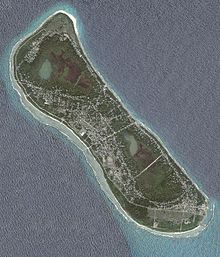
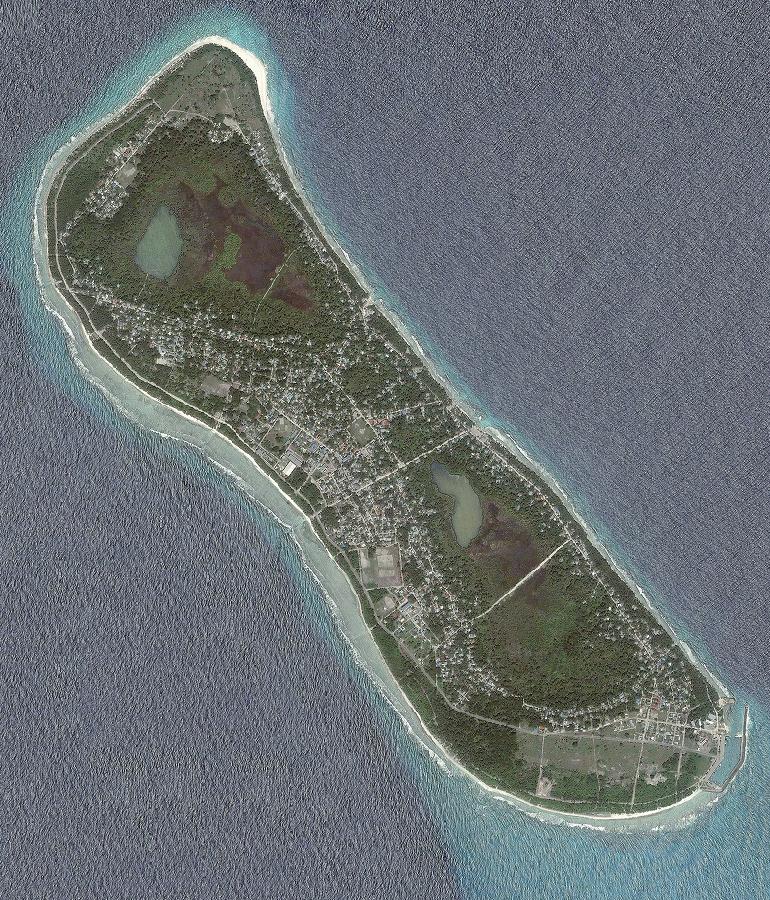
Island Summary Belongs to Gnaviyani Atoll Location 0°16′45″S 73°24′30″E / 0.27917°S 73.40833°ECoordinates: 0°16′45″S 73°24′30″E / 0.27917°S 73.40833°E Population 11140 (June 2010) Length 4500 m Width 1200 m Distance from Malé 494 km Fuvahmulah (Dhivehi: ފުވައްމުލައް) is a large single island (by itself a small detached atoll) in the Maldives. It is one of the administrative divisions of the Maldives under the name Gnaviyani Atoll or Nyaviyani Atoll. The inhabitants speak a distinctive form of the Dhivehi language, known as Mulaku bas.
The name of this island means "Island of the Areca nut palms", Fuvah (or "Fua") in the local language. Other places in the world like Penang in Malaysia and Guwahati in Assam, India, are also named after this nut. The original name of the island could have simply been Mulah, but was called Fuvahmulah (the Mulah with the arecanut palms) to distinguish it from Boli Mulah- another important island in ancient Maldives.[1]
The admiralty charts and some geographers used the name of the island as Fua Mulaku. In old French maps the island appeared with the name Poue Molluque.[2]
Geography
The island is about 4.5 km by 1.2 km with a submerged reef (Rashikedefaro) extending for about three km in a SE direction. In the distant past Fvahmulah was a small coral atoll whose southern end was open at a spot called Diyarehifaando and the inside of the island was a saltwater lagoon forming a natural harbour. There is a spot in the southern end known as a Kudhuheraival (the forest of the small islet), which indicates that there was a separate little island in that area in ancient times. But long ago the channel connecting the lagoon with the ocean was closed by massive coral boulders. Thus the inside of the island is lower than its edges. In time the inner lagoon lost its saltiness and all that remains today are two small lakes, wetlands and marshy taro fields. Therefore Fuvahmulah is a small Atoll that closed and filled in with silt, like Nukutavake in the Central Pacific.
The northern lake of the island is known as "Dhadimagi-Kilhi" and the southern is known as "Bandaara-Kilhi" (lit. 'Harbour Lake' because formerly there was much talk among the locals about making a harbour by connecting it with the sea through a canal). Lacking a lagoon and being subject to violent ocean swells, Fuvahmulah was often inaccessible to seafarers. In the early 2000s a harbor has been built at the SE tip of the island, which has minimized the problem to a certain extent.
Municipal Divisions
Fuvahmulah was traditionally divided into nine wards. From North to South these wards were: (1) Dhadimago, (2) Diguvāndo (both stretching from East to West shore), (3) Hōdhado, (5) Dhashokubaa (both segmental) separated by, (4) Mādhado (A diagonal strip of parallel width); whilst the other four divisions, which occupied the Southern part of the island consisted of two Eastern and Western strips, bisected into four wards, (6) Mālegan and (8) Dūndigan lying to East, (7) Miskimmago and (9) Funādo to West.
With time, some changes saw its way into existence. In the 1950s, the number of wards were reduced to eight, with the village of Dhashokubaa being merged with Miskimmago. Since then, no changes were made formally though the increase in population of some wards putting pressure on the neighbouring areas resulted in the extension of some wards with time and some claims out of the traditional bounds. An example of such a case is that of Hōdhado ward. The northerly extension of the settlements of Hōdhado ward by time led to the land from Eastern strip of Dhiguvaando and Dhadimago wards being claimed to the village.[3] A similar case occurred in the Funaado-Dundingan boundaries to the south of the island.[4] However, no formal changes have been made in any of the cases and area claims of different views remain up to this day. The officially used maps and government sources as well do not portray any significant changes to the traditional bounds.[5] Thus, the gradual boundaries of the wards are still to be decided and are subject to change.
Taking into consideration the geography of Fuvahmulah along with its size and population, the 8 wards of the island are officially considered to be administrative divisions which act as the replacement for islands in other atolls. In the past, a chief ('Katheeb') was appointed as in charge of the day-to-day affairs of each ward of the island as was done for the remote lying islands of the other atolls. With the introduction of local government policy in Maldives, the Decentralisation Act 2010 passed by the People's majlis specifically states that in case of Fuvahmulah an island council has to be elected for each ward of the island. So like the islands of other atolls across the country, the wards of the island act as separate constituencies. From February 2011 onwards the councils have started functioning.
Each ward of Fuvahmulah has its own distinctive features. The largest division of the island is Dhadimago while most populous ward of the island is Dūndigan.
Dhadimagu
This is the largest division of the island,[6][7] located on the north-west of the island. A center of learning as well as an important location for the island's economy. Throughout history, notable scholars and famous personalities came into being from this remarkable district housing many of the renowned historical sites and illustrious landmarks of the island. The number of 'Hafiz's from this district outnumber that of any other district in Fuvahmulah.
Places of interest
- Thoondu: A white sandy beach on the north of the island. The most well known feature of Dhadimago as well as that of the whole Fuvahmulah. Hundreds of people visit this beach everyday, and this figure is much higher in special occasions like Maahibun.
- Dhadimagi kilhi: One among the two fresh water lakes in Fuvahmulah. Found in the center of the district.
- Gemmiskiy: The oldest building in Fuvahmulah. In the pre-islamic period was a part of the Buddhist monastery and later stood up to be the first mosque to be built after the whole island converted to Islam.[8]
- The Havitta: An ancient ruin of possibly a Buddhist stupa. Located within the historical boundaries of the district.
- Madharusathu-Sheikh Mohammed Jamaaluddeen: One of the four primary schools in Fuvahmulah. This school has been the most successful primary school throughout the years.[9]
- Ulaa pre-school: One of the pre-schools (Kindergarten) in Fuvahmulah.
- Dhanbo Baal (Dhanvah Baal): A dense vegetation of Syzygium cumini (Jambul) locally known as Dhanvah associated with the Dhadimagi Kilhi. Wood from the trees durable in water and resistant to termites were used for boat building as well as for construction purposes in the past. Not only the islanders benefited from it, but was also exported to the neighbouring atolls. This plant variety nearly extinct elsewhere in the Maldives compared to the rich vegetation over here makes this spot a remarkable location.
- Dhadimago Fanno: An iconic feature of Dhadimago, used for recreational purposes. This figure is much higher in occasions like Eid. For Eid celebrations this place stands out to be the number one in Fuvahmulah throughout history.
- Neregando: A famous anchorage of Fuvahmulah which has been a traditional harbour as well. Also, is a landmark of the boat building industry of the island.
Dhiguvaandu
Located just after Dhadimago, this is one of the largest districts in Fuvahmulah.[6] This village houses some extraordinary features of the island. Apart from Dhadimago, the district also share borders with Hōdhado and Mādhado.
Most residents of Diguvāndo rely heavily on white collar jobs for income. Apart from this, retail business is also a main source of income. Perhaps the most prominent feature of this district is the "Chas bin" (an area of wet land) associated with the Dhadimagi-Kilhi. Huge amounts of Taro fields can be found in the wet land area. Vast amounts of Areca nut can be found around the district. Mango and Breadfruit also can be found in a reasonable quantity. Almost every house in the district have a Mango tree despite a few houses built recently.
Places of interest
- The Wathaniya communications antenna: It's located in the Aruffanno Mago and Mohammed Jamaaluddin Naibu Thutthu Mago junction and it is the tallest structure in the Maldives, along with the Dhiraagu Communications antenna in the island. Both structures stand 400 feet tall.
- Foundation School: One of the pre-schools in Fuvahmulah.
- Aruffanno: A traditional harbour (anchorage) of the island.
- A significant part of the marsh land area associated with the Dhadimagi Kilhi. One of the best scenery one could find in Fuvahmulah.
Hoadhadu
Main article: HoadhaduHōdhado has been the smallest district in Fuvahmulah throughout history. During the late 20th century, the increase in population of the district led to pressure on land from the neighbouring areas. This led to the northerly extension of the village resulting in land from Dhadimago and Diguvando wards being claimed to the village. Though this has resulted in a change of the believed-to-be areas in a disputed state, no formal changes have been made and the gradual area of the ward is still to be decided.
Hōdhado is the first district in Fuvahmulah to have accepted Islam.[10] The smaller size of the village with less people during the time of conversion proves to be the main reason for the village being the first district to be converted fully. What's clear from historical sources is that it was the smaller districts of Fuvahmulah which converted first and the larger districts at last with their size and population acting as a main obstacle.[11] Hōdhado is a remarkable ward in Fuvahmulah. Historically, many residents of Hōdhado depended on fishing as the primary source of income, although today retail business along with white collar jobs have diminished the dependency on fishing. One of the traditional harbours of Fuvahmulah, "Anbule Athiri" is located within Hōdhado which explains the district's dependency on fishing.
Places of interest
- Anbule Athiri: One of the traditional harbours of Fuvahmulah.
- Naaibu Aboobakuru School: One of the four primary schools in Fuvahmulah.
- Hanihari Miskiy: One of the oldest mosques in Fuvahmulah built during the earliest days of Islam in Fuvahmulah.
- Hoadhadu Miskiy: One of the oldest mosques in Fuvahmulah built during the earliest days of Islam in Fuvahmulah.
Claimed places:
- The Havitta: An ancient ruin of possibly a Buddhist stupa. Due to the northerly extension of the village towards the end of the 20th Century and settlement of the villagers in the area by time, today the Havitta is considered to be a part of this village though the Havitta is within the historical boundaries of the district of Dhadimago.
Maadhadu
With changes over time, this is the smallest district in Fuvahmulah. Located in the center of the island, this district houses the strategically most important buildings in the island. This district shares borders with Diguvāndo, Hōdhado, Mālegan and Miskimmago.[6]
Places of interest
- The Dhiraagu communications antenna: The tallest structure in the Maldives, along with the Wathaniya communications antenna in the island. Both structures stand 400 feet tall.
- Atoll Office: The highest administrative unit of the atoll as a whole.
- Island Office: The headquarters of the island chiefs appointed for the 8 wards of the island.
- Gn. Atoll Education Centre: The only Secondary as well as Higher Secondary School in Fuvahmulah.
- Wataniya Fuvahmulaku Branch
- State Trading Organization Fuvahmulaku Branch
- Bank of Maldives Fuvahmulaku Branch
- MNDF establishment in Fuvahmulah
- Fuvahmulaku Police Station
- Fuvahmulaku Youth Centre
- Fuvahmulaku Social Centre
Maalegan
This village stretches along the island fringe facing the Northeast. With some of the most significant features of the island this district shares borders with Mādhado, Miskimmago, Funādo and Dūndigan.[6]
Places of interest
- Hukuru Miskih: One of the most significant mosques in the island being the only friday mosque in the island for long throughout history.
- Bandaara Kilhi: One of the two fresh water lakes in the island. The main lake in its true sense is located within this ward with about three-fourth of the whole lake along with its major areas centered within this ward.
- Rasgefanno: Previously, the most famous anchorage of the island.
- Maalegan Preschool: One of the preschools (Kindergarten) in Fuvahmulah.
Miskiymagu
The former Dashokubai village was merged with Miskiymago. With some important features and useful landmarks this village has merged with neighboring Funādo on its southern end and Madhado on its northern end.[6] Also, the village shares borders with Maalegan ward towards the north-east of the village.
Places of interest
- Gn. Atoll Education Centre: The only Secondary as well as Higher Secondary School in Fuvahmulah.
- Heraha Mago: The transverse street which cuts across this village which houses the most significant features of the village including the Fire and Rescue Service Building, the Local Market as well as many of the important businesses. Mānere anchorage can be found at the southern tip of the street. About three-fourth of the Heraha mago is within Miskiymago and the remaining one-fourth is within Maalegan ward to the north-east of the district.
- Mānere: A historical harbour (anchorage) of Fuvahmulah. This anchorage was used in the NE monsoon season (Iruvai).
- Bandaara Kilhi: One of the two fresh water lakes in Fuvahmulah.[6] About one-fourth of the lake (a segmental part) is located in Miskiymago.
- The Local Market: All agricultural products as well as traditional food varieties of Fuvahmulah can be obtained from this place.
- The Fire and Rescue Service Building
Funaadu
Main article: FunaaduThis is the southernmost and one of the largest wards in Fuvahmulah.[6] This district houses some of the important features of the island being a center of learning as well.
Places of interest
- Bondo Kirigehe (Bodu Nikagas): Allegedly the oldest tree in Fuvahmulah.
- Hafiz Ahmed School: One of the four primary schools in Fuvahmulah.
- Diyarehifaando: The mouth of the island's lagoon in the past.
- Ribaath: A historical shrine from the ancient past.
- "Kalho akiri gando": A unique location of black pebbles which can be found in the beach areas of Funaadu and Dūndigan.
Dhoondigan
This is the most populous district and by area the second largest division of the island. This village lies in the Southeastern corner of the island. It has merged with Mālegan on its northern end. Being a centre of learning as well as an important location for all the islanders as it houses the island harbour, a significant number of historical landmarks can also be found from the district.
Places of interest
- Vashoveyo: A famous historical location.
- "Bilihifeyshe neru": One of the famous anchorages (traditional harbours) of Fuvahmulah.
- "Kalho akiri gando": A unique location of black pebbles which can be found in the beach areas of Funaadu and Dūndigan.
- Fuvahmulaku School: One of the four primary schools in Fuvahmulah.
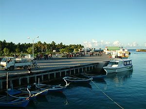 The new harbor.
Demography/Communication
The high rate of fertility has resulted in overpopulation. With more than 10,000 inhabitants, the availability of land for market gardening is steadily diminishing. The most updated population figure for the island is available on Ministry of Atolls Development website, which states that as of March 2007, the island had a population of 5117 women and 5389 men, giving a total of 10506. This gives a sex ratio of 0.95.
Dhiraagu is the only landline telephone communication service provider in the island, as well as in the entire country. However though, Wataniya along with Dhiraagu provides mobile communication services in the island. The Dhiraagu communications antenna, located in the premises of Dhiraagu Fuvahmulah Operations Centre, is the tallest structure in the Maldives. The antenna stands 400 feet (121 meters) tall. It connects Gaafu Alif Atoll, Gaafu Dhaalu Atoll and Fuvahmulah to the rest of the nation. Apart from Dhiraagu, Focus Infocom Private Limited provides internet services in the island.
Transport
Formerly there were many bicycles in Fuvahmulah, an ideal mode of transportation in this flat, large island. But presently there is a great number of motorcycles. The construction of Fuvahmulah Harbor has given way to a sudden boost in the number of vehicles - notably motor cycles - in the island. This, on the other hand has increased road accidents, many of them fatal. It is also to be noted that the poorly constructed roads, have indirectly contributed to road accidents. Finivaa Magu, the main road running from north to south of the island, along with other roads are not paved. The only paved road is the Mohamed Jamaaludeen Naibu Thutthu Magu. While this road is still under construction, part of it has been paved. When completed this road will be the longest road in the island running from the harbour, connecting all 8 districts.
An airstrip is functional in the SE side of the island since 11.11.2011. Currently there are four scheduled flights per week to Male'.
Health Services
The first Health Centre officially started its services on May 12, 1973. Even though the centre was fully owned by the government, it did not have its own building. Therefore the centre operated in a private house. A separate building for the Health Centre was constructed and the services began in the new building on March 24, 1988. President Maumoon Abdul Gayoom inaugurated the new building. As the population of the island increased significantly, and due to the isolation of the island, government upgraded the Health Centre to a Hospital on June 11, 2001.
Education
Fuvahmulah is served by 10 schools. Consisting of 6 pre-schools, 3 primary schools and a secondary school. Gn. Atoll Education Centre, the only secondary school serving the island is the largest education centre in the island. Inaugurated on April 20, 1982, it currently serves more than 1000 students. Fuvahmulaku School (FS) which was owned and operated by the citizens of Dūndigan, is one of the three primary schools in the island. Located in Dūndigan, it serves the south west part of the island. Government assumed full control over the school on March 1, 1992. Madharusathu-Sheik Mohammed Jamaaluddeen (MJM), opened on November 3, 1992 serves north-west part of the island. The school was built by the people of Dhadimago and Dhiguvaado. This is also a primary school and has been the most successful primary school in Fuvahmulah.[12] The other primary school in the island is Hafiz Ahmed School (usually referred as HAS) which was opened on April 22, 2004. It currently serves more than 500 students.
Law Enforcement and Security
Historically the island was and still is, considered as a peaceful island with low crime rates. However crime rate has gone up especially with regards to drugs. A regional branch of the Maldives Police Service was established in the island on October 7, 1996. Back then the Police and the Armed Forces of the Maldives were the same, known as National Security Service. The main objective of Fuvahmulaku Police Station is to maintain peace, stability and harmony across the atoll and carryout investigations into crimes and public complaints in a fair and friendly manner to deliver justice to the locals of the atoll. The station also helps other government authorities in fighting and preventing crime. The station is commanded by chief Station Inspector Ahmed Shameem.
The establishment of the NSS (National Security Service) also means that the armed forces of the Maldives established themselves in the island. However the police was separated from the armed forces (MNDF) in 2006. MNDF still operates in the island, but separated from police. They are mostly active in the area of Fire and Rescue, along with military duties. The Defense Institute for Training and Education, a part of MNDF occasionally conducts training programs for new recruits in the island.
Notable events
On February 4, 2007 a fire at the Community Center burnt down the whole building. The fire started around 3:00 AM local time. The Regional Fire Services, Maldives Police Services along with locals contained the fire, almost 2 hours after the fire started. Although investigation was carried out by the Police, no reports were published. Police said that the most possible cause of the fire was an electrical short. However most locals believe that the fire was intentionally started given that President Gayyoom was scheduled to visit the island just two days after the fire.
On February 23, 2007 a fire started at the boat yard near the harbour.[13] The fire completely burnt 6 fiber glass dhows. 4 of these dhows were 100 feet and the remaining 2 were 40 feet long. This fire also started around 03:40 AM local time. Fire was first spotted, instantly after the fire started by a local fisherman. The Fire Service was called immediately. But since fiber glass resin is highly flammable, and there was no sprinkler system, the fire spread to the 6 dhows and the fiber glass resin barrels in the yard. It took the fire personnel, Maldives National Defence Force and local 2 hours to contain the fire. A forensics team of the Maldive Police Service did the investigation. All the dhows were insured. In an interview with media, the atoll chief said the loss is estimated to be around MRF 20 Million, although insurance companies never publicly disclosed the figures. This fire is said to be the worst fire in the history of the island.
History
Little is known about the history of Fuvahmulah. All that remains are some landmarks of the historical past. These include a much damaged Buddhist stupa known as Fua Mulaku Havitta. Its actual shape has been lost because of the damage done by careless diggings to find valuable artifacts or for bungled research purposes. The ruin is about 40 feet in height and it looks like a small hill. A smaller mound, about 15 feet in height, is located near the Havitta.
An ancient local poem says: "Havitta uhe haudahau, Redin taneke hedi ihau". This poem gives us the clue about the name Redin. Thor Heyerdahl erroneously claimed that Redin were people coming from somewhere else, but according to Magieduruge Ibrahim Didi, a learned man from this island, it was the name which the converted Maldivians ,ghairu deen (non-muslim), ancestors after the general conversion to Islam. (Thor Heyerdahl visited this island and wrote a book which is named 'Fua Mulaku' in its German edition.)
There is also the Vasho-Veyo, an ancient circular bath with stone steps. This stone pool reveals great craftsmanship in the cutting of Porites coral stone (hirigal) by the locals.
Among the monuments of the Islamic period, the most important is Gemmiskiy, a neat compound including a coral stone mosque, an ancient graveyard and a well. It is located in the northern end of the island. Gemmiskiy is said to be the oldest mosque in Fuvahmulah.
It has been said that the island was depopulated and resettled thrice in the last thousand years owing to lethal epidemics. The last time the survivors of the epidemic went to the neighbouring Addu, Huvadhu and Haddhunmathi Atolls and stayed there for a few years.
One historical characteristic of this island is that only members of the Maldive Royal family or belonging to the very high nobility were exiled to the island. During long exiles, some nobles married local ladies. This accounts for the many families in Fuvahmulah that claim noble descent by having the title 'Dīdī' appended to their names.
During the secession of the Southern Atolls from the North (1959–1963), Fuvahmulah was a part of the Suvadive Islands. Nothing eventful happened during those years except that once a boat (Elizabeth Boyer) with soldiers from Male' sent by the central government tried to disembark unsuccessfully at Rasgefanno. The island people gathered at the beach and threw stones to the soldiers. The latter fired and one man of the island died instantly. The bullet hit him in the head and his skull burst open. Two islanders who were seriously wounded by gun shots were ferried by dōni the same day, to Gan, in Addu Atoll. The British, who were stationed in Gan sent them by air to Ceylon for treatment.
Natural Phenomena
There is a beautiful broad sandy beach at the northernmost point of Fuvahmulah in the district of Dhadimago. It is locally known as "Thūndu" (In official Dhivehi "Thundi"). Its sands are formed by white small round pebbles, which are unusually smooth and shiny. It used to be common for an annual phenomenon called Bissaaveli to form at the Thūndu. The Bissaaveli forms when part of the sand of the beach moves away from the shore towards the edge of the reef, thus creating a lagoon, enclosed by sand and the shore of the island. This natural event attracts hundreds - possibly thousands - of locals who love to go to watch it. When it is well-formed, the Bissaveli is enclosed from all sides, creating a natural shallow swimming pool where locals like to swim. However, since the construction of the Fuvahmulah harbor began in 2000, this phenomenon has not occurred. It is believed that the construction of harbor somehow affected the current patterns around the island which previously caused this natural phenomenon.
Another natural phenomenon called Kalho-Akiri (meaning "Black Pebbles") occurs in the south-east shore of the island. This area only has black pebbles, quite unusual to the normal white coral sand beaches of the Maldives. However, the construction of a harbor has adversely affected this phenomenon as well.
Every year, towards the end of the SW monsoon season, flying fish (Hulhammaha) come to the northwestern shore of Fuvahmulah. Confused by the number of voracious tuna shoals in the water and by aggressive frigate birds hunting them from the air, the flying fish would end up flying close to the beach. They mostly endup in the area between Thoondu and Dhadimago fanno where this phenomenon is most common. Men, women and children like to go down to the reef to catch the flying fishes by hand in the midst of a joyful atmosphere. Large crowds will gather in the beaches for what the locals called "Hulhammaha Hifun".
Notables
Many figures from Fuvahmulah have had been leaders in politics, religion and in business since early times. One of the most notable figures is the Independence Hero of Maldives, Former President Ibrahim Nasir. Nasir was born in Fuvahmulah. The childhood days of Nasir were spent in Fuvahmulah till the time his family moved to Male'.
Another important figure from Fuvahmulah is the all-time famous Dhivehi poet Mohammad Jamaaluddeen, also known as Naibu-Thutthu. He wrote several raivaru (Maldive couplets) books. These raivarus are still taught and examined in schools, as part of Dhivehi language module. Not only was he good at literature, but also was appointed as chief justice.
The former chief justice Ustaz Mohamed Rasheed Ibrahim is also from Fuvahmulah. He was also the president of Supreme Council for Islamic Affairs. Dr.Mohamed Zahir Hussain, Founder of the most popular daily newspaper Haveeru and former minister is also a native Fuvahmulah citizen. Among other notables from the island include the former Minister of Housing and Urban Development, Mr. Ibrahim Rafeeq, former Minister of Communication as well as Minister of Justice, Dr. Mohamed Jameel Ahmed and former Editor in Chief of Haveeru Daily and Haveeru Online, Dr.Ali Rafeeq.
Some Other Notables from History
- Al-Faqeeh Al-Hafiz Yousuf Naib Thakurufan
- Algedharu Naibu Kaleyfan
- Alla Kaleyge
- An-Naib As-Shaikh Ibrahim Saeed
- Bandaara Kaleyge
- Beyrefeerhe Don Faathin
- Dhadimagigey Ahmed Khateeb Thakurufan
- Dhadimagigey Hussain Kateeb Thakurufan
- Dhadimagu Ganduvaru Mariyam Didi
- Dhaigandu Don Isa Kateeb Kaleyfan
- Dhaigandu Maafaiy Kaleyfan
- Dhaigandu Maafaiy Thakurufan
- Dhamaliye Don Bulhali Kambulo
- Dhoodeyru Mariam Didi
- Dhoodeyru Naibu Kaleyfan
- Dhoodigamu Eduru Kaleyfan
- Dhoodigamu Haji Kaleyge Ahmed Kaleyge Aminah Manike
- Dhoodigamu Ismail Didi
- Don Hussain Kateeb Kaleyge
- Don Abaakiru Kaleyge
- Donbiya
- Dondhani
- Edurugey Aminah Didi
- Elhagedharu Don Seedi
- Elhagedharu Donbee Kaleyge
- Fahamaliye Don Umar
- Feerhi Don Thakuru
- Finivaagey Ali Moosa Didi {Kalhuthutthu Didi}
- Funaadu Ganduvaru Ahmed Didi
- Funaadu Ganduvaru Ahmed Didi ge Sanfa Didi
- Funaadu Ganduvaru Don Didi
- Funaadu Ganduvaru Don Didi ge Vaarugey Ahmed Didi
- Funaadu Ganduvaru Don Didi ge Vaarugey Moosa Didi
- Funaadu Ganduvaru Hawwa Didi ge Edurugey Rugiyya Didi
- Haanaaru Don Kaidhaa
- Haanaaru Kateeb
- Hoadhandu Don Bulhali Kambuleyge
- Hunuboliye Ibrahim Didi
- Ihalagedharu Don Umar Kaleyge
- Kadeyre Maria
- Kalhihaaraa Don Maniku
- Karayya Aminah Manikfan
- Karayya Ganduvaru Ahmed Didi ge Dhiyarehi Aminah Didi
- Karayya Ganduvaru Ahmed Didi ge Dhiyarehi Don Didi
- Karayya Ganduvaru Kudhu Didi
- Karayya Ganduvaru Mohamed Didi ge Edurugey Ali Didi
- Karayya Ganduvaru Mohamed Didi ge Edurugey Daleikha Didi
- Karayya Ganduvaru Mohamed Didi ge Edurugey Hasan Didi
- Karayya Ganduvaru Mohamed Didi ge Edurugey Tuteedi
- Koi Ari Don Ahmed kaleyge
- Kulhuverey Ali Thakurufan
- Maadhandu Kateeb Kaleyge
- Maadholhie Elha Thakurufan
- Madigey Kaalege (feminine of Kaleyge)
- Madigey Kaleyge
- Miskiy Magu Edurugey Mariam Manikfan
- Miskiydorhugey (Dhadimagu) Aminah
- Mohamed Bandaara Thakuru
- Nayaagey Reki Didi (Abdulla Mufeed)
- Randhuvaru Mohamed Didi
- Randhuvaru Reki Didi
- Satharu Hasan Didi ge Fatima Didi
- Sultan Mohamed Ghiyathuddine ge Abdulla Faamuladeyri Kilegefan ge Kuda Raniye Dorhy Didi
- Vaarulu Ali Thakurufan
- Vaimatheegey Aminah Didi
See also
References
- HCP Bell, The Maldive Islands, An account of the physical features, History, Inhabitants, Productions and Trade. Colombo 1883, ISBN 81 206 1222 1
- H.C.P Bell, The Maldive Islands - Monograph on the History, Archaeology and Epigraphy. Colombo 1940, ISBN 99915 3 051 7
- Xavier Romero-Frias, The Maldive Islanders, A Study of the Popular Culture of an Ancient Ocean Kingdom. Barcelona 1999, ISBN 84 7254 801 5
- ^ Divehiraajjege Jōgrafīge Vanavaru. Muhammadu Ibrahim Lutfee. G.Sōsanī.
- ^ [1]
- ^ http://webcache.googleusercontent.com/search?q=cache:8ecTJmljnYAJ:mikalnews.com/v23/index.php%3Fread%3D1132+%DE%8B%DE%AB%DE%91%DE%A8%DE%8E%DE%A6%DE%89%DE%AA+%DE%87%DE%A6%DE%88%DE%A6%DE%81%DE%A7%DE%87%DE%A8+%DE%8A%DE%AA%DE%82%DE%A7%DE%91%DE%AA+%DE%87%DE%A6%DE%88%DE%A6%DE%81%DE%AA%DE%8E%DE%AC+%DE%8B%DE%AC%DE%89%DE%AC%DE%8B%DE%AA%DE%8E%DE%A6%DE%87%DE%A8+%DE%80%DE%AF%DE%8B%DE%A6%DE%91%DE%AA+%DE%87%DE%A6%DE%88%DE%A6%DE%81%DE%A7%DE%87%DE%A8+%DE%8B%DE%A6%DE%91%DE%A8%DE%89%DE%A6%DE%8E%DE%AA+%DE%87%DE%A6%DE%88%DE%A6%DE%81%DE%A7%DE%87%DE%A8+%DE%8B%DE%AC%DE%89%DE%AC%DE%8B%DE%AA%DE%8E%DE%A6%DE%87%DE%A8&cd=1&hl=en&ct=clnk&gl=mv
- ^ http://webcache.googleusercontent.com/search?q=cache:8ecTJmljnYAJ:mikalnews.com/v23/index.php%3Fread%3D1132+%DE%8B%DE%AB%DE%91%DE%A8%DE%8E%DE%A6%DE%89%DE%AA+%DE%87%DE%A6%DE%88%DE%A6%DE%81%DE%A7%DE%87%DE%A8+%DE%8A%DE%AA%DE%82%DE%A7%DE%91%DE%AA+%DE%87%DE%A6%DE%88%DE%A6%DE%81%DE%AA%DE%8E%DE%AC+%DE%8B%DE%AC%DE%89%DE%AC%DE%8B%DE%AA%DE%8E%DE%A6%DE%87%DE%A8+%DE%80%DE%AF%DE%8B%DE%A6%DE%91%DE%AA+%DE%87%DE%A6%DE%88%DE%A6%DE%81%DE%A7%DE%87%DE%A8+%DE%8B%DE%A6%DE%91%DE%A8%DE%89%DE%A6%DE%8E%DE%AA+%DE%87%DE%A6%DE%88%DE%A6%DE%81%DE%A7%DE%87%DE%A8+%DE%8B%DE%AC%DE%89%DE%AC%DE%8B%DE%AA%DE%8E%DE%A6%DE%87%DE%A8&cd=1&hl=en&ct=clnk&gl=mv
- ^ http://www.elections.gov.mv/v2/media/documents/114..pdf
- ^ a b c d e f g [2]
- ^ [3]
- ^ http://www.meedhoolive.com/?p=1544
- ^ http://www.kattelhi.com/?page=article&action=readitem&item=692
- ^ http://www.meedhoolive.com/?p=1544
- ^ http://www.meedhoolive.com/?p=1544
- ^ [4]
- ^ "Haveeru News". http://www.haveeru.com.mv/beta/?page=details&id=49215&cat=search.
External links
- Fuvahmulah Photo Collection
- Fuvahmulaku Development Corporation
- (Dhivehi) Articles about Fuvahmulah - Haveeru Online
Categories:- Islands of the Maldives
- Atolls of the Maldives
- Geography of the United Suvadive Republic
- Atolls of the Indian Ocean
- Populated places in the Maldives

Wikimedia Foundation. 2010.