- Nukutavake
-
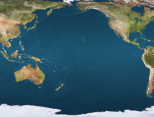
 NukutavakeLocation of Nukutavake Island in the Pacific Ocean
Nukutavake 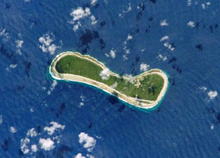
NASA picture of Nukutuvake IslandGeography Location Pacific Ocean Coordinates 19°16′S 138°46′W / 19.267°S 138.767°W Archipelago Tuamotu Archipelago Total islands 4 Area 5.5 km2 (2.12 sq mi) Country FranceOverseas collectivity French Polynesia Largest city Tavananui Demographics Population 139 (as of 2002) Nukutavake
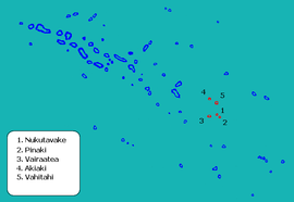
Location of Nukutavake in the Tuamotu Archipelago Administration Country France Overseas collectivity French Polynesia Administrative subdivision Îles Tuamotu-Gambier Statistics Elevation 0 m (0 ft) avg. Land area 13 km2 (5.0 sq mi) Population1 334 (2002) - Density 26 /km2 (67 /sq mi) 1 Population without double counting: residents of multiple communes (e.g., students and military personnel) only counted once. Coordinates: 19°17′11″S 138°47′49″W / 19.286297°S 138.797°W
Nukutavake or Nukutuvake is an island in the Tuamotu group in French Polynesia. It lies 1,125 km from Tahiti. The closest land is small Pinaki Atoll, located 15 km to the southeast. Vairaatea Atoll lies 38 km to the west of Nukutavake.
Nukutavake's length is 5 km and its width between 1.3 and 0.45 km. Nukutuvake is not a typical Tuamotu atoll, but a single island. It was formed when its lagoon filled up with silt, in a similar manner as Fua Mulaku in the Maldives, which has a similar size and shape. There are shallow remains of the lagoon filled with marshy vegetation. The higher ground has many coconut palms.
Nukutavake has 139 inhabitants; Tavananui is the largest town. Many islanders have left the island in recent years, mainly to Tahiti, in search for work. There are a number of abandoned houses on the island. The people who remain live primarily on fish and copra production. There is a cyclone shelter on Nukutavake
Contents
History
The first recorded European who arrived to Nukutavake was Englishman Samuel Wallis in 1767. He named it "Queen Charlotte Island" (Reine Charlotte). Wallis observed that the island was inhabited and well-stocked with coconut trees. But Captain Frederick Beechey, who visited Nukutavake in 1826, found it with no population and without the trees. It is likely that the early inhabitants experienced a ``mini-apocolypse```, and came to a horrific end.
Administration
Geographically this island is part of the East-central subgroup of the Tuamotus, which includes Ahunui, Amanu, Fangatau, Hao and Nukutavake.
The commune of Nukutavake includes four other islands apart from Nukutavake itself:
Island Population (2002 census) Area (km²) Area of lagoon (km²) Postcode Nukutavake 139 5.5 0 98773 Vahitahi 103 2.5 7.4 98788 Vairaatea 36 3 13 98791 Pinaki 0 1.3 0.7 - Akiaki 0 1.2 0 - TOTAL 334 13 - - Nukutavake airport
There is an airfield on the island, Nukutavake Airport, inaugurated in 1981: (IATA: NUK, ICAO: NTGW).
References
External links
Categories:- Atolls of the Tuamotus
- Communes of French Polynesia
- French Polynesia geography stubs


Wikimedia Foundation. 2010.