- Napuka
-
Napuka

Location of Napuka in the Tuamotu Archipelago Administration Country France Overseas collectivity French Polynesia Administrative subdivision Îles Tuamotu-Gambier Statistics Elevation 0 m (0 ft) avg. Land area 1 km2 (0.39 sq mi) Population1 257 (2002) - Density 257 /km2 (670 /sq mi) 1 Population without double counting: residents of multiple communes (e.g., students and military personnel) only counted once. Coordinates: 16°30′22″S 179°55′10″W / 16.506139°S 179.919403°W
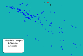
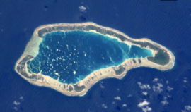
Napuka, or Pukaroa, is a small coral atoll in the Disappointment Islands, in the north-eastern part of the Tuamotu Archipelago in French Polynesia. It is located only 15 km to the southeast of Tepoto Nord, its nearest neighbor, forming a small group. These two atolls are quite isolated, the nearest land being Fangatau Atoll 170 km to the south.
Napuka Atoll is 10.5 km long and about 4 km wide. Its reef is quite broad, completely enclosing the lagoon. The total dry land area of the 30 islands on Napuka's reef is 8 km². The surface of the lagoon is 18 km².
Napuka has 257 inhabitants according to the 2002 census. The main village is Tepukamaruia (Te Puka Maru Ia).
Contents
History
The first recorded European to reach Napuka Atoll was British explorer John Byron in 1765. He named Napuka and Tepoto "Disappointment Islands" because the natives were of a hostile disposition.
Napuka was visited by the historic United States Exploring Expedition, 1838-1842. This atoll was most probably the one that Charles Wilkes called "Wytoohee" or "Wutoohee".
The airport in Napuka was inaugurated in 1977.
Administration
Napuka Atoll is the head of the commune of Napuka, which consists of the atolls of Napuka and Tepoto Nord.
References
- oceandots.com
- Atoll names
- Origin of the name (in German)
- United States Exploring Expedition, - Charles Wilkes
- Napuka airport
External links
Categories:- Communes of French Polynesia
- Atolls of the Tuamotus
- French Polynesia geography stubs
Wikimedia Foundation. 2010.

