- Nukutepipi
-
Coordinates: 20°41′S 143°04′W / 20.683°S 143.067°W
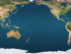
 NukutepipiLocation of Nukutepipi Atoll in the Pacific Ocean
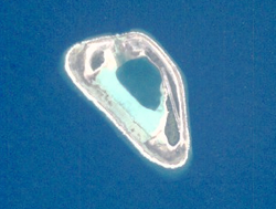
Nukutepipi, or Nuku-te-pipi is an atoll in French Polynesia, Pacific Ocean. It is part of the Duke of Gloucester Islands, a subgroup of the Tuamotu group. Nukutepipi's nearest neighbor is Anuanurunga, which is located about 22 km to the WNW.
Nukutepipi is a very small atoll. It is roughly triangular-shaped, measuring approximately 2.7 km in length. Its reef is quite broad, enclosing completely the small lagoon, which has a deep area at its centre. There are two relatively large islands on its reef, one on its eastern side and the other on the northwest.
Nukutepipi Atoll has 2 inhabitants. It has a small airfield which was inaugurated in 1982.
Contents
History
The first recorded European to sight Nukutepipi Atoll was British naval officer and explorer Philip Carteret in 12 July 1767 who only referred to it in his logs as "the southernmost island". [1] John Turnbull aboard the Margaret March 6, 1803 named it "Margaret island" after their ship. The atoll was visited by lieutenant Ringgold of the Wilkes Expedition on the 6 January 1841. He identified the correct name of the atoll as "Nukutipipi" by the natives.
Administration
Administratively the four atolls of the Duke of Gloucester Islands, including the uninhabited ones of Nukutepipi, Anuanuruga, and Anuanuraro, belong to the commune of Hereheretue, which is associated to the Hao commune.
References
External links

Tuamotus

GambiersIslands/Atolls: Ahe • Ahunui • Akiaki • Amanu • Anaa* • Anuanuraro • Anuanurunga • Apataki • Aratika • Arutua* • Faaite • Fakahina • Fakarava* • Fangatau* • Fangataufa • Hao* • Haraiki • Hereheretue • Hikueru* • Hiti • Katiu • Kauehi • Kaukura • Makatea • Makemo* • Manihi* • Manuhangi • Maria Est • Marokau • Marutea (North) • Marutea (South) • Mataiva • Matureivavao • Morane • Moruroa • Motutunga • Napuka* • Nengonengo • Niau • Nihiru • Nukutavake* • Nukutepipi • Paraoa • Pinaki • Puka Puka* • Pukaruha • Rangiroa* • Raraka • Raroia • Ravahere • Reao* • Reitoru • Rekareka • Taenga • Tahanea • Taiaro • Takapoto • Takaroa* • Takume • Tatakoto* • Tauere • Tekokota • Tematangi • Temoe • Tenararo • Tenarunga • Tepoto (North) • Tepoto (South) • Tikehau • Tikei • Toau • Tuanake • Tureia* • Vahanga • Vahitahi • Vairaatea • Vanavana Island groups: Acteon • Disappointment • Duke of Gloucester • King George • Two Groups • Palliser • RaeffksyCategories:
- Atolls of the Tuamotus
- French Polynesia geography stubs


Wikimedia Foundation. 2010.