- Manuhangi
-
Coordinates: 19°14′S 141°15′W / 19.233°S 141.25°W
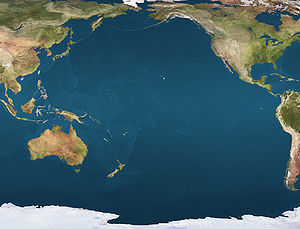
 ManuhangiLocation of Manuhangi in the Pacific Ocean
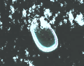
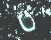 NASA picture of Manuhangi atoll
Manuhangi (also known as Te Fara[1]) is an atoll of the Tuamotu Archipelago in French Polynesia. The atoll is situated 68 km southeast from Nengonengo and 52 km west from Paraoa.[2]
Manuhangi Atoll is small in size,[2] with a length of 5.4 km and a maximum width of 3.6 km. It has an oval shape and a coral reef completely enclosing a small lagoon. Manuhangi has a hook-shaped island covering the east and northeast of its reef.
Contents
History
The old Paumotu (Tuamotu’s inhabitants) called this small atoll "manu hagi" (meaning "the loving bird").[3] The atoll has been uninhabited for many years.[3]
The first recorded European who arrived to Manuhangi was English navigator Samuel Wallis in 1767.[3] He named it "Cumberland".
Administration
Administratively Manuhangi belongs to the commune of Hao (main village: Otepa), which includes Ahunui (uninhabited), Nengonengo, Manuhangi (no permanent inhabitant) and Paraoa (uninhabited).
Flora and fauna
Manuhangi is a protected area and various species of birds are found in the atoll.[3] Part of the land is planted with coconut palms.[4] Apart from the birds, the fauna of the island primarily consists of coconut crabs.[4]
Economy and infrastructure
Tahitian black pearls are collected and cultivated in the surrounding islands.[3] The island has some houses with permanent structures, cisterns, and water supply from natural wells.[4] Manuhangi has no permanent inhabitant.[5]
References
- ^ Atoll names Journal of the Polynesian Society
- ^ a b Manuhangi Oceandots.com
- ^ a b c d e Manuhangi Atoll Privateislandsonline.com
- ^ a b c Manuhangi Atoll Pavilionsofsplendourinternational.com
- ^ United Nations Environment Programme, IUCN Commission on National Parks and Protected Areas (1986). Review of the Protected Areas System in Oceania. The World Conservation Union. pp. p207. ISBN 2880325099.

Tuamotus

GambiersIslands/Atolls: Ahe • Ahunui • Akiaki • Amanu • Anaa* • Anuanuraro • Anuanurunga • Apataki • Aratika • Arutua* • Faaite • Fakahina • Fakarava* • Fangatau* • Fangataufa • Hao* • Haraiki • Hereheretue • Hikueru* • Hiti • Katiu • Kauehi • Kaukura • Makatea • Makemo* • Manihi* • Manuhangi • Maria Est • Marokau • Marutea (North) • Marutea (South) • Mataiva • Matureivavao • Morane • Moruroa • Motutunga • Napuka* • Nengonengo • Niau • Nihiru • Nukutavake* • Nukutepipi • Paraoa • Pinaki • Puka Puka* • Pukaruha • Rangiroa* • Raraka • Raroia • Ravahere • Reao* • Reitoru • Rekareka • Taenga • Tahanea • Taiaro • Takapoto • Takaroa* • Takume • Tatakoto* • Tauere • Tekokota • Tematangi • Temoe • Tenararo • Tenarunga • Tepoto (North) • Tepoto (South) • Tikehau • Tikei • Toau • Tuanake • Tureia* • Vahanga • Vahitahi • Vairaatea • Vanavana * commune administration centerIsland groups: Acteon • Disappointment • Duke of Gloucester • King George • Two Groups • Palliser • RaeffksyCategories:
- Atolls of the Tuamotus

Wikimedia Foundation. 2010.