- Tenarunga
-
Coordinates: 21°19′S 136°32′W / 21.317°S 136.533°W
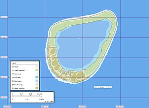 Map of Tenarunga Atoll
Tenarunga or Tenania, formerly Minto Island, 15 km NNW of Matureivavao, is a low, wooded and uninhabited atoll in the Acteon Group in the southeastern part of the Tuamotu Islands. There are some buildings and a dock located on the north-east side of the island, indicating former and/or seasonal habitation.
The atoll's lagoon is not accessible from the sea.
Administration
Administratively Tenarunga, like the rest of the Acteon Group, belongs to the municipality of the Gambier Islands.
References
- Sailing Directions, Pub 126, "Pacific Islands" NIMA 2002; page-12
External links

Tuamotus

GambiersIslands/Atolls: Ahe • Ahunui • Akiaki • Amanu • Anaa* • Anuanuraro • Anuanurunga • Apataki • Aratika • Arutua* • Faaite • Fakahina • Fakarava* • Fangatau* • Fangataufa • Hao* • Haraiki • Hereheretue • Hikueru* • Hiti • Katiu • Kauehi • Kaukura • Makatea • Makemo* • Manihi* • Manuhangi • Maria Est • Marokau • Marutea (North) • Marutea (South) • Mataiva • Matureivavao • Morane • Moruroa • Motutunga • Napuka* • Nengonengo • Niau • Nihiru • Nukutavake* • Nukutepipi • Paraoa • Pinaki • Puka Puka* • Pukaruha • Rangiroa* • Raraka • Raroia • Ravahere • Reao* • Reitoru • Rekareka • Taenga • Tahanea • Taiaro • Takapoto • Takaroa* • Takume • Tatakoto* • Tauere • Tekokota • Tematangi • Temoe • Tenararo • Tenarunga • Tepoto (North) • Tepoto (South) • Tikehau • Tikei • Toau • Tuanake • Tureia* • Vahanga • Vahitahi • Vairaatea • Vanavana * commune administration centerIsland groups: Acteon • Disappointment • Duke of Gloucester • King George • Two Groups • Palliser • RaeffksyCategories:
- Atolls of the Tuamotus
- French Polynesia geography stubs

Wikimedia Foundation. 2010.