- Marokau
-
Coordinates: 18°04′S 142°16′W / 18.067°S 142.267°W

Marokau is an atoll of the Tuamotu Archipelago in French Polynesia. It lies 53 km southeast of Hikueru Atoll and it is separated by a 2 km wide sound from Ravahere, its closest neighbor in the south.
Marokau and Ravahere form a minor subgroup of the Tuamotus known as the Two Groups Islands.
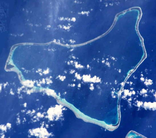
Marokau Atoll is roughly triangular. The islands on its reef have a combined land area of 14.7 km². The shallow lagoon has a surface of 217 km².[1]
Marokau has 55 inhabitants. Most live in Vaiori, the main village, located on an island at its northern end. The locals collect copra from the numerous coconut palms planted on the islands and motus.[2] There is another small village called Topitike in its south-eastern corner.[3]
Contents
History
The first recorded European who sighted the two neighboring atolls of Marokau and Ravahere was Louis Antoine de Bougainville in 1768.[4]
Marokau Atoll was one of the main locations in the Tuamotu lagoons at which pearls were collected from the nineteenth century up to 1965.[5]
Administration
Marokau Atoll belongs to the commune of Hikueru, which consists of the atolls of Marokau, Hikueru, Ravahere, Reitoru and Tekokota.[5]
References
- ^ Marokau
- ^ Hoarau, Olivier. "The atoll of Marokau (french)". http://olivier.funix.org/polynesie/marokau.htm. Retrieved 2008-03-03.
- ^ "opitike, French Polynesia (general), French Polynesia". rumbletum.org. http://rumbletum.org/Oceana/French%20Polynesia/French+Polynesia+(general)/_4033277_Topitike.html#themap. Retrieved 2008-03-03.
- ^ Robson, John (2005). "A short biography of Louis-Antoine de Bougainville". http://pages.quicksilver.net.nz/jcr/~boug2.html. Retrieved 2008-03-03.
- ^ a b "Marokau". The Institute for Research and Development. http://www.com.univ-mrs.fr/IRD/atollpol/irdpoly/ukmaroka.htm. Retrieved 2008-03-03.
External links

Tuamotus

GambiersIslands/Atolls: Ahe • Ahunui • Akiaki • Amanu • Anaa* • Anuanuraro • Anuanurunga • Apataki • Aratika • Arutua* • Faaite • Fakahina • Fakarava* • Fangatau* • Fangataufa • Hao* • Haraiki • Hereheretue • Hikueru* • Hiti • Katiu • Kauehi • Kaukura • Makatea • Makemo* • Manihi* • Manuhangi • Maria Est • Marokau • Marutea (North) • Marutea (South) • Mataiva • Matureivavao • Morane • Moruroa • Motutunga • Napuka* • Nengonengo • Niau • Nihiru • Nukutavake* • Nukutepipi • Paraoa • Pinaki • Puka Puka* • Pukaruha • Rangiroa* • Raraka • Raroia • Ravahere • Reao* • Reitoru • Rekareka • Taenga • Tahanea • Taiaro • Takapoto • Takaroa* • Takume • Tatakoto* • Tauere • Tekokota • Tematangi • Temoe • Tenararo • Tenarunga • Tepoto (North) • Tepoto (South) • Tikehau • Tikei • Toau • Tuanake • Tureia* • Vahanga • Vahitahi • Vairaatea • Vanavana Island groups: Acteon • Disappointment • Duke of Gloucester • King George • Two Groups • Palliser • RaeffksyCategories:
- Atolls of the Tuamotus
- French Polynesia geography stubs
Wikimedia Foundation. 2010.