- Earth
-
This article is about the planet. For other uses, see Earth (disambiguation).
Earth 
 Designations
Pronunciation  i/ˈɜrθ/
Adjective earthly, earthling, tellurian, telluric, terran, terrestrial. Epoch J2000.0[note 1] Aphelion 152,098,232 km
1.01671388 AU[note 2]Perihelion 147,098,290 km
0.98329134 AU[note 2]Semi-major axis 149,598,261 km
1.00000261 AU[1]Eccentricity 0.01671123[1] Orbital period 365.256363004 days[2]
1.000017421 yrAverage orbital speed 29.78 km/s[3]
107,200 km/hMean anomaly 357.51716°[3] Inclination 7.155° to Sun's equator
1.57869°[4] to invariable planeLongitude of ascending node 348.73936°[3][note 3] Argument of perihelion 114.20783°[3][note 4] Satellites 1 natural (The Moon)
8,300+ artificial (as of 1 March 2001[update])[5]Physical characteristicsMean radius 6,371.0 km[6] Equatorial radius 6,378.1 km[7][8] Polar radius 6,356.8 km[9] Flattening 0.0033528[10] Circumference 40,075.017 km (equatorial)[8]
40,007.86 km (meridional)[11]Surface area 510,072,000 km2[12][13][note 5] 148,940,000 km2 land (29.2 %)
361,132,000 km2 water (70.8 %)Volume 1.08321×10¹² km3[3] Mass 5.9736×1024 kg[3] Mean density 5.515 g/cm3[3] Equatorial surface gravity 9.780327 m/s2[14]
0.99732 gEscape velocity 11.186 km/s[3] Sidereal rotation
period0.99726968 d[15]
23h 56m 4.100sEquatorial rotation velocity 1,674.4 km/h (465.1 m/s)[16] Axial tilt 23°26'21".4119[2] Albedo 0.367 (geometric)[3]
0.306 (Bond)[3]Surface temp.
Kelvin
Celsiusmin mean max 184 K[17] 287.2 K[18] 331 K[19] -89.2 °C 14 °C 57.8 °C AtmosphereSurface pressure 101.325 kPa (MSL) Composition 78.08% nitrogen (N2)[3]
20.95% oxygen (O2)
0.93% argon
0.038% carbon dioxide
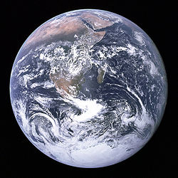
About 1% water vapor (varies with climate)Earth (or the Earth) is the third planet from the Sun, and the densest and fifth-largest of the eight planets in the Solar System. It is also the largest of the Solar System's four terrestrial planets. It is sometimes referred to as the World, the Blue Planet,[20] or by its Latin name, Terra.[note 6]
Earth formed 4.54 billion years ago, and life appeared on its surface within one billion years.[21] The planet is home to millions of species, including humans.[22] Earth's biosphere has significantly altered the atmosphere and other abiotic conditions on the planet, enabling the proliferation of aerobic organisms as well as the formation of the ozone layer which, together with Earth's magnetic field, blocks harmful solar radiation, permitting life on land.[23] The physical properties of the Earth, as well as its geological history and orbit, have allowed life to persist during this period. The planet is expected to continue supporting life for at least another 500 million years.[24][25]
Earth's outer surface is divided into several rigid segments, or tectonic plates, that migrate across the surface over periods of many millions of years. About 71% of the surface is covered by salt water oceans, with the remainder consisting of continents and islands which together have many lakes and other sources of water that contribute to the hydrosphere. Earth's poles are mostly covered with solid ice (Antarctic ice sheet) or sea ice (Arctic ice cap). The planet's interior remains active, with a thick layer of relatively solid mantle, a liquid outer core that generates a magnetic field, and a solid iron inner core.
Earth interacts with other objects in space, especially the Sun and the Moon. At present, Earth orbits the Sun once every 366.26 times it rotates about its own axis, which is equal to 365.26 solar days, or one sidereal year.[note 7] The Earth's axis of rotation is tilted 23.4° away from the perpendicular of its orbital plane, producing seasonal variations on the planet's surface with a period of one tropical year (365.24 solar days).[26] Earth's only known natural satellite, the Moon, which began orbiting it about 4.53 billion years ago, provides ocean tides, stabilizes the axial tilt, and gradually slows the planet's rotation. Between approximately 3.8 billion and 4.1 billion years ago, numerous asteroid impacts during the Late Heavy Bombardment caused significant changes to the greater surface environment.
Both the mineral resources of the planet, as well as the products of the biosphere, contribute resources that are used to support a global human population.[27] These inhabitants are grouped into about 200 independent sovereign states, which interact through diplomacy, travel, trade, and military action. Human cultures have developed many views of the planet, including personification as a deity, a belief in a flat Earth or in the Earth as the center of the universe, and a modern perspective of the world as an integrated environment that requires stewardship.
Contents
Chronology
Main article: History of the EarthSee also: Geological history of EarthThe earliest dated Solar System material was formed 4.5672 ± 0.0006 billion years ago,[28] and by 4.54 billion years ago (within an uncertainty of 1%)[21] the Earth and the other planets in the Solar System had formed out of the solar nebula—a disk-shaped mass of dust and gas left over from the formation of the Sun. This assembly of the Earth through accretion was thus largely completed within 10–20 million years.[29] Initially molten, the outer layer of the planet Earth cooled to form a solid crust when water began accumulating in the atmosphere. The Moon formed shortly thereafter, 4.53 billion years ago.[30]
The current consensus model[31] for the formation of the Moon is the giant impact hypothesis, in which the Moon was created when a Mars-sized object (sometimes called Theia) with about 10% of the Earth's mass[32] impacted the Earth in a glancing blow.[33] In this model, some of this object's mass would have merged with the Earth and a portion would have been ejected into space, but enough material would have been sent into orbit to coalesce into the Moon.
Outgassing and volcanic activity produced the primordial atmosphere of the Earth. Condensing water vapor, augmented by ice and liquid water delivered by asteroids and the larger proto-planets, comets, and trans-Neptunian objects produced the oceans.[34] The newly formed Sun was only 70% of its present luminosity, yet evidence shows that the early oceans remained liquid—a contradiction dubbed the faint young Sun paradox. A combination of greenhouse gases and higher levels of solar activity served to raise the Earth's surface temperature, preventing the oceans from freezing over.[35] By 3.5 billion years ago, the Earth's magnetic field was established, which helped prevent the atmosphere from being stripped away by the solar wind.[36]
Two major models have been proposed for the rate of continental growth:[37] steady growth to the present-day[38] and rapid growth early in Earth history.[39] Current research shows that the second option is most likely, with rapid initial growth of continental crust[40] followed by a long-term steady continental area.[41][42][43] On time scales lasting hundreds of millions of years, the surface continually reshaped as continents formed and broke up. The continents migrated across the surface, occasionally combining to form a supercontinent. Roughly 750 million years ago (Ma), one of the earliest known supercontinents, Rodinia, began to break apart. The continents later recombined to form Pannotia, 600–540 Ma, then finally Pangaea, which broke apart 180 Ma.[44]
Evolution of life
Main article: Evolutionary history of lifeHighly energetic chemistry is believed to have produced a self-replicating molecule around 4 billion years ago and half a billion years later the last common ancestor of all life existed.[45] The development of photosynthesis allowed the Sun's energy to be harvested directly by life forms; the resultant oxygen accumulated in the atmosphere and formed a layer of ozone (a form of molecular oxygen [O3]) in the upper atmosphere. The incorporation of smaller cells within larger ones resulted in the development of complex cells called eukaryotes.[46] True multicellular organisms formed as cells within colonies became increasingly specialized. Aided by the absorption of harmful ultraviolet radiation by the ozone layer, life colonized the surface of Earth.[47]
Since the 1960s, it has been hypothesized that severe glacial action between 750 and 580 Ma, during the Neoproterozoic, covered much of the planet in a sheet of ice. This hypothesis has been termed "Snowball Earth", and is of particular interest because it preceded the Cambrian explosion, when multicellular life forms began to proliferate.[48]
Following the Cambrian explosion, about 535 Ma, there have been five major mass extinctions.[49] The most recent such event was 65 Ma, when an asteroid impact triggered the extinction of the (non-avian) dinosaurs and other large reptiles, but spared some small animals such as mammals, which then resembled shrews. Over the past 65 million years, mammalian life has diversified, and several million years ago an African ape-like animal such as Orrorin tugenensis gained the ability to stand upright.[50] This enabled tool use and encouraged communication that provided the nutrition and stimulation needed for a larger brain, which allowed the evolution of the human race. The development of agriculture, and then civilization, allowed humans to influence the Earth in a short time span as no other life form had,[51] affecting both the nature and quantity of other life forms.
The present pattern of ice ages began about 40 Ma and then intensified during the Pleistocene about 3 Ma. High-latitude regions have since undergone repeated cycles of glaciation and thaw, repeating every 40–100,000 years. The last continental glaciation ended 10,000 years ago.[52]
Future
Main article: Future of the Earth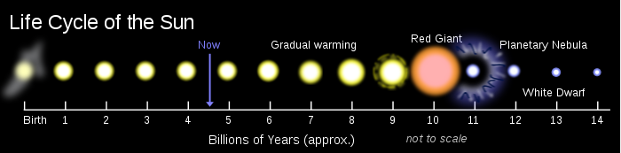 The life cycle of the Sun
The future of the planet is closely tied to that of the Sun. As a result of the steady accumulation of helium at the Sun's core, the star's total luminosity will slowly increase. The luminosity of the Sun will grow by 10% over the next 1.1 Gyr (1.1 billion years) and by 40% over the next 3.5 Gyr.[53] Climate models indicate that the rise in radiation reaching the Earth is likely to have dire consequences, including the loss of the planet's oceans.[54]
The Earth's increasing surface temperature will accelerate the inorganic CO2 cycle, reducing its concentration to levels lethally low for plants (10 ppm for C4 photosynthesis) in approximately 500 million[24] to 900 million years. The lack of vegetation will result in the loss of oxygen in the atmosphere, so animal life will become extinct within several million more years.[55] After another billion years all surface water will have disappeared[25] and the mean global temperature will reach 70 °C[55] (158 °F). The Earth is expected to be effectively habitable for about another 500 million years from that point,[24] although this may be extended up to 2.3 billion years if the nitrogen is removed from the atmosphere.[56] Even if the Sun were eternal and stable, the continued internal cooling of the Earth would result in a loss of much of its CO2 due to reduced volcanism,[57] and 35% of the water in the oceans would descend to the mantle due to reduced steam venting from mid-ocean ridges.[58]
The Sun, as part of its evolution, will become a red giant in about 5 Gyr. Models predict that the Sun will expand out to about 250 times its present radius, roughly 1 AU (150,000,000 km).[53][59] Earth's fate is less clear. As a red giant, the Sun will lose roughly 30% of its mass, so, without tidal effects, the Earth will move to an orbit 1.7 AU (250,000,000 km) from the Sun when the star reaches it maximum radius. The planet was therefore initially expected to escape envelopment by the expanded Sun's sparse outer atmosphere, though most, if not all, remaining life would have been destroyed by the Sun's increased luminosity (peaking at about 5000 times its present level).[53] A 2008 simulation indicates that Earth's orbit will decay due to tidal effects and drag, causing it to enter the red giant Sun's atmosphere and be vaporized.[59]
Composition and structure
Main article: Earth scienceFurther information: Earth physical characteristics tablesEarth is a terrestrial planet, meaning that it is a rocky body, rather than a gas giant like Jupiter. It is the largest of the four solar terrestrial planets in size and mass. Of these four planets, Earth also has the highest density, the highest surface gravity, the strongest magnetic field, and fastest rotation,[60] and is probably the only one with active plate tectonics.[61]
Shape
Main article: Figure of the Earth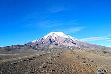
The shape of the Earth approximates an oblate spheroid, a sphere flattened along the axis from pole to pole such that there is a bulge around the equator.[63] This bulge results from the rotation of the Earth, and causes the diameter at the equator to be 43 km larger than the pole-to-pole diameter.[64] For this reason the closest point to the outer space is the Chimborazo volcano in Ecuador.[65] The average diameter of the reference spheroid is about 12,742 km, which is approximately 40,000 km/π, as the meter was originally defined as 1/10,000,000 of the distance from the equator to the North Pole through Paris, France.[66]
Local topography deviates from this idealized spheroid, although on a global scale, these deviations are small: Earth has a tolerance of about one part in about 584, or 0.17%, from the reference spheroid, which is less than the 0.22% tolerance allowed in billiard balls.[67] The largest local deviations in the rocky surface of the Earth are Mount Everest (8848 m above local sea level) and the Mariana Trench (10,911 m below local sea level). Because of the equatorial bulge, the surface locations farthest from the center of the Earth are the summits of Mount Chimborazo in Ecuador and Huascarán in Peru.[68][69][70]
Chemical composition of the crust[71] Compound Formula Composition Continental Oceanic silica SiO2 60.2% 48.6% alumina Al2O3 15.2% 16.5% lime CaO 5.5% 12.3% magnesia MgO 3.1% 6.8% iron(II) oxide FeO 3.8% 6.2% sodium oxide Na2O 3.0% 2.6% potassium oxide K2O 2.8% 0.4% iron(III) oxide Fe2O3 2.5% 2.3% water H2O 1.4% 1.1% carbon dioxide CO2 1.2% 1.4% titanium dioxide TiO2 0.7% 1.4% phosphorus pentoxide P2O5 0.2% 0.3% Total 99.6% 99.9% Chemical composition
See also: Abundance of elements on EarthThe mass of the Earth is approximately 5.98×1024 kg. It is composed mostly of iron (32.1%), oxygen (30.1%), silicon (15.1%), magnesium (13.9%), sulfur (2.9%), nickel (1.8%), calcium (1.5%), and aluminium (1.4%); with the remaining 1.2% consisting of trace amounts of other elements. Due to mass segregation, the core region is believed to be primarily composed of iron (88.8%), with smaller amounts of nickel (5.8%), sulfur (4.5%), and less than 1% trace elements.[72]
The geochemist F. W. Clarke calculated that a little more than 47% of the Earth's crust consists of oxygen. The more common rock constituents of the Earth's crust are nearly all oxides; chlorine, sulfur and fluorine are the only important exceptions to this and their total amount in any rock is usually much less than 1%. The principal oxides are silica, alumina, iron oxides, lime, magnesia, potash and soda. The silica functions principally as an acid, forming silicates, and all the commonest minerals of igneous rocks are of this nature. From a computation based on 1,672 analyses of all kinds of rocks, Clarke deduced that 99.22% were composed of 11 oxides (see the table at right), with the other constituents occurring in minute quantities.[73]
Internal structure
Main article: Structure of the EarthThe interior of the Earth, like that of the other terrestrial planets, is divided into layers by their chemical or physical (rheological) properties, but unlike the other terrestrial planets, it has a distinct outer and inner core. The outer layer of the Earth is a chemically distinct silicate solid crust, which is underlain by a highly viscous solid mantle. The crust is separated from the mantle by the Mohorovičić discontinuity, and the thickness of the crust varies: averaging 6 km under the oceans and 30–50 km on the continents. The crust and the cold, rigid, top of the upper mantle are collectively known as the lithosphere, and it is of the lithosphere that the tectonic plates are comprised. Beneath the lithosphere is the asthenosphere, a relatively low-viscosity layer on which the lithosphere rides. Important changes in crystal structure within the mantle occur at 410 and 660 kilometers below the surface, spanning a transition zone that separates the upper and lower mantle. Beneath the mantle, an extremely low viscosity liquid outer core lies above a solid inner core.[74] The inner core may rotate at a slightly higher angular velocity than the remainder of the planet, advancing by 0.1–0.5° per year.[75]
Geologic layers of the Earth[76] 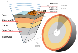
Earth cutaway from core to exosphere. Not to scale.Depth[77]
kmComponent Layer Density
g/cm30–60 Lithosphere[note 8] — 0–35 Crust[note 9] 2.2–2.9 35–60 Upper mantle 3.4–4.4 35–2890 Mantle 3.4–5.6 100–700 Asthenosphere — 2890–5100 Outer core 9.9–12.2 5100–6378 Inner core 12.8–13.1 Heat
Earth's internal heat comes from a combination of residual heat from planetary accretion (about 20%) and heat produced through radioactive decay (80%).[78] The major heat-producing isotopes in the Earth are potassium-40, uranium-238, uranium-235, and thorium-232.[79] At the center of the planet, the temperature may be up to 7,000 K and the pressure could reach 360 GPa.[80] Because much of the heat is provided by radioactive decay, scientists believe that early in Earth history, before isotopes with short half-lives had been depleted, Earth's heat production would have been much higher. This extra heat production, twice present-day at approximately 3 billion years ago,[78] would have increased temperature gradients within the Earth, increasing the rates of mantle convection and plate tectonics, and allowing the production of igneous rocks such as komatiites that are not formed today.[81]
Present-day major heat-producing isotopes[82] Isotope Heat release
W/kg isotopeHalf-life
yearsMean mantle concentration
kg isotope/kg mantleHeat release
W/kg mantle238U 9.46 × 10⁻⁵ 4.47 × 10⁹ 30.8 × 10⁻⁹ 2.91 × 10⁻¹² 235U 5.69 × 10⁻⁴ 7.04 × 10⁸ 0.22 × 10⁻⁹ 1.25 × 10⁻¹³ 232Th 2.64 × 10⁻⁵ 1.40 × 10¹⁰ 124 × 10−9 3.27 × 10⁻¹² 40K 2.92 × 10⁻⁵ 1.25 × 10⁹ 36.9 × 10⁻⁹ 1.08 × 10⁻¹² The mean heat loss from the Earth is 87 mW m−2, for a global heat loss of 4.42 × 10¹³ W.[83] A portion of the core's thermal energy is transported toward the crust by mantle plumes; a form of convection consisting of upwellings of higher-temperature rock. These plumes can produce hotspots and flood basalts.[84] More of the heat in the Earth is lost through plate tectonics, by mantle upwelling associated with mid-ocean ridges. The final major mode of heat loss is through conduction through the lithosphere, the majority of which occurs in the oceans because the crust there is much thinner than that of the continents.[85]
Tectonic plates
Earth's main plates[86] 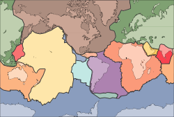
Plate name Area
106 km2African Plate[note 10] 78.0 Antarctic Plate 60.9 Indo-Australian Plate 47.2 Eurasian Plate 67.8 North American Plate 75.9 South American Plate 43.6 Pacific Plate 103.3 Main article: Plate tectonicsThe mechanically rigid outer layer of the Earth, the lithosphere, is broken into pieces called tectonic plates. These plates are rigid segments that move in relation to one another at one of three types of plate boundaries: Convergent boundaries, at which two plates come together, Divergent boundaries, at which two plates are pulled apart, and Transform boundaries, in which two plates slide past one another laterally. Earthquakes, volcanic activity, mountain-building, and oceanic trench formation can occur along these plate boundaries.[87] The tectonic plates ride on top of the asthenosphere, the solid but less-viscous part of the upper mantle that can flow and move along with the plates,[88] and their motion is strongly coupled with convection patterns inside the Earth's mantle.
As the tectonic plates migrate across the planet, the ocean floor is subducted under the leading edges of the plates at convergent boundaries. At the same time, the upwelling of mantle material at divergent boundaries creates mid-ocean ridges. The combination of these processes continually recycles the oceanic crust back into the mantle. Because of this recycling, most of the ocean floor is less than 100 million years in age. The oldest oceanic crust is located in the Western Pacific, and has an estimated age of about 200 million years.[89][90] By comparison, the oldest dated continental crust is 4030 million years old.[91]
The seven major plates are the Pacific, North American, Eurasian, African, Antarctic, Indo-Australian, and South American. Other notable plates include the Arabian Plate, the Caribbean Plate, the Nazca Plate off the west coast of South America and the Scotia Plate in the southern Atlantic Ocean. The Australian Plate fused with the Indian Plate between 50 and 55 million years ago. The fastest-moving plates are the oceanic plates, with the Cocos Plate advancing at a rate of 75 mm/yr[92] and the Pacific Plate moving 52–69 mm/yr. At the other extreme, the slowest-moving plate is the Eurasian Plate, progressing at a typical rate of about 21 mm/yr.[93]
Surface
Main articles: Landform and Extreme points of EarthThe Earth's terrain varies greatly from place to place. About 70.8%[94] of the surface is covered by water, with much of the continental shelf below sea level. The submerged surface has mountainous features, including a globe-spanning mid-ocean ridge system, as well as undersea volcanoes,[64] oceanic trenches, submarine canyons, oceanic plateaus and abyssal plains. The remaining 29.2% not covered by water consists of mountains, deserts, plains, plateaus, and other geomorphologies.
The planetary surface undergoes reshaping over geological time periods because of tectonics and erosion. The surface features built up or deformed through plate tectonics are subject to steady weathering from precipitation, thermal cycles, and chemical effects. Glaciation, coastal erosion, the build-up of coral reefs, and large meteorite impacts[95] also act to reshape the landscape.
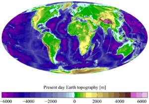 Present-day Earth altimetry and bathymetry. Data from the National Geophysical Data Center's TerrainBase Digital Terrain Model.
The continental crust consists of lower density material such as the igneous rocks granite and andesite. Less common is basalt, a denser volcanic rock that is the primary constituent of the ocean floors.[96] Sedimentary rock is formed from the accumulation of sediment that becomes compacted together. Nearly 75% of the continental surfaces are covered by sedimentary rocks, although they form only about 5% of the crust.[97] The third form of rock material found on Earth is metamorphic rock, which is created from the transformation of pre-existing rock types through high pressures, high temperatures, or both. The most abundant silicate minerals on the Earth's surface include quartz, the feldspars, amphibole, mica, pyroxene and olivine.[98] Common carbonate minerals include calcite (found in limestone) and dolomite.[99]
The pedosphere is the outermost layer of the Earth that is composed of soil and subject to soil formation processes. It exists at the interface of the lithosphere, atmosphere, hydrosphere and biosphere. Currently the total arable land is 13.31% of the land surface, with only 4.71% supporting permanent crops.[13] Close to 40% of the Earth's land surface is presently used for cropland and pasture, or an estimated 1.3×10⁷ km2 of cropland and 3.4×10⁷ km2 of pastureland.[100]
The elevation of the land surface of the Earth varies from the low point of −418 m at the Dead Sea, to a 2005-estimated maximum altitude of 8,848 m at the top of Mount Everest. The mean height of land above sea level is 840 m.[101]
Hydrosphere
Main article: Hydrosphere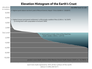 Elevation histogram of the surface of the Earth
The abundance of water on Earth's surface is a unique feature that distinguishes the "Blue Planet" from others in the Solar System. The Earth's hydrosphere consists chiefly of the oceans, but technically includes all water surfaces in the world, including inland seas, lakes, rivers, and underground waters down to a depth of 2,000 m. The deepest underwater location is Challenger Deep of the Mariana Trench in the Pacific Ocean with a depth of −10,911.4 m.[note 11][102]
The mass of the oceans is approximately 1.35×10¹⁸ metric tons, or about 1/4400 of the total mass of the Earth. The oceans cover an area of 3.618×10⁸ km2 with a mean depth of 3,682 m, resulting in an estimated volume of 1.332×10⁹ km3.[103] If all the land on Earth were spread evenly, water would rise to an altitude of more than 2.7 km.[note 12] About 97.5% of the water is saline, while the remaining 2.5% is fresh water. Most fresh water, about 68.7%, is currently ice.[104]
The average salinity of the Earth's oceans is about 35 grams of salt per kilogram of sea water (35 ‰).[105] Most of this salt was released from volcanic activity or extracted from cool, igneous rocks.[106] The oceans are also a reservoir of dissolved atmospheric gases, which are essential for the survival of many aquatic life forms.[107] Sea water has an important influence on the world's climate, with the oceans acting as a large heat reservoir.[108] Shifts in the oceanic temperature distribution can cause significant weather shifts, such as the El Niño-Southern Oscillation.[109]
Atmosphere
Main article: Atmosphere of EarthThe atmospheric pressure on the surface of the Earth averages 101.325 kPa, with a scale height of about 8.5 km.[3] It is 78% nitrogen and 21% oxygen, with trace amounts of water vapor, carbon dioxide and other gaseous molecules. The height of the troposphere varies with latitude, ranging between 8 km at the poles to 17 km at the equator, with some variation resulting from weather and seasonal factors.[110]
Earth's biosphere has significantly altered its atmosphere. Oxygenic photosynthesis evolved 2.7 billion years ago, forming the primarily nitrogen-oxygen atmosphere of today. This change enabled the proliferation of aerobic organisms as well as the formation of the ozone layer which blocks ultraviolet solar radiation, permitting life on land. Other atmospheric functions important to life on Earth include transporting water vapor, providing useful gases, causing small meteors to burn up before they strike the surface, and moderating temperature.[111] This last phenomenon is known as the greenhouse effect: trace molecules within the atmosphere serve to capture thermal energy emitted from the ground, thereby raising the average temperature. Water vapor, carbon dioxide, methane and ozone are the primary greenhouse gases in the Earth's atmosphere. Without this heat-retention effect, the average surface would be −18 °C, in contrast to the current +15 °C, and life would likely not exist.[94]
Weather and climate

The Earth's atmosphere has no definite boundary, slowly becoming thinner and fading into outer space. Three-quarters of the atmosphere's mass is contained within the first 11 km of the planet's surface. This lowest layer is called the troposphere. Energy from the Sun heats this layer, and the surface below, causing expansion of the air. This lower density air then rises, and is replaced by cooler, higher density air. The result is atmospheric circulation that drives the weather and climate through redistribution of heat energy.[112]
The primary atmospheric circulation bands consist of the trade winds in the equatorial region below 30° latitude and the westerlies in the mid-latitudes between 30° and 60°.[113] Ocean currents are also important factors in determining climate, particularly the thermohaline circulation that distributes heat energy from the equatorial oceans to the polar regions.[114]
Water vapor generated through surface evaporation is transported by circulatory patterns in the atmosphere. When atmospheric conditions permit an uplift of warm, humid air, this water condenses and settles to the surface as precipitation.[112] Most of the water is then transported to lower elevations by river systems and usually returned to the oceans or deposited into lakes. This water cycle is a vital mechanism for supporting life on land, and is a primary factor in the erosion of surface features over geological periods. Precipitation patterns vary widely, ranging from several meters of water per year to less than a millimeter. Atmospheric circulation, topological features and temperature differences determine the average precipitation that falls in each region.[115]
The amount of solar energy reaching the Earth's decreases with increasing latitude. At higher latitudes the sunlight reaches the surface at a lower angles and it must pass through thicker columns of the atmosphere. As a result, the mean annual air temperature at sea level decreases by about 0.4°C per per degree of latitude away from the equator.[116] The Earth can be sub-divided into specific latitudinal belts of approximately homogeneous climate. Ranging from the equator to the polar regions, these are the tropical (or equatorial), subtropical, temperate and polar climates.[117] Climate can also be classified based on the temperature and precipitation, with the climate regions characterized by fairly uniform air masses. The commonly used Köppen climate classification system (as modified by Wladimir Köppen's student Rudolph Geiger) has five broad groups (humid tropics, arid, humid middle latitudes, continental and cold polar), which are further divided into more specific subtypes.[113]
Upper atmosphere
 This view from orbit shows the full Moon partially obscured and deformed by the Earth's atmosphere. NASA imageSee also: Outer space
Above the troposphere, the atmosphere is usually divided into the stratosphere, mesosphere, and thermosphere.[111] Each layer has a different lapse rate, defining the rate of change in temperature with height. Beyond these, the exosphere thins out into the magnetosphere, where the Earth's magnetic fields interact with the solar wind.[118] Within the stratosphere is the ozone layer, a component that partially shields the surface from ultraviolet light and thus is important for life on Earth. The Kármán line, defined as 100 km above the Earth's surface, is a working definition for the boundary between atmosphere and space.[119]
Thermal energy causes some of the molecules at the outer edge of the Earth's atmosphere have their velocity increased to the point where they can escape from the planet's gravity. This results in a slow but steady leakage of the atmosphere into space. Because unfixed hydrogen has a low molecular weight, it can achieve escape velocity more readily and it leaks into outer space at a greater rate than other gasses.[120] The leakage of hydrogen into space contributes to the pushing of the Earth from an initially reducing state to its current oxidizing one. Photosynthesis provided a source of free oxygen, but the loss of reducing agents such as hydrogen is believed to have been a necessary precondition for the widespread accumulation of oxygen in the atmosphere.[121] Hence the ability of hydrogen to escape from the Earth's atmosphere may have influenced the nature of life that developed on the planet.[122] In the current, oxygen-rich atmosphere most hydrogen is converted into water before it has an opportunity to escape. Instead, most of the hydrogen loss comes from the destruction of methane in the upper atmosphere.[123]
Magnetic field
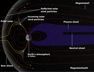 Schematic of Earth's magnetosphere. The solar wind flows from left to rightMain article: Earth's magnetic field
The Earth's magnetic field is shaped roughly as a magnetic dipole, with the poles currently located proximate to the planet's geographic poles. At the equator of the magnetic field, the magnetic field strength at the planet's surface is 3.05 × 10⁻⁵ T, with global magnetic dipole moment of 7.91 × 10¹⁵ T m3.[124] According to dynamo theory, the field is generated within the molten outer core region where heat creates convection motions of conducting materials, generating electric currents. These in turn produce the Earth's magnetic field. The convection movements in the core are chaotic; the magnetic poles drift and periodically change alignment. This results in field reversals at irregular intervals averaging a few times every million years. The most recent reversal occurred approximately 700,000 years ago.[125][126]
The field forms the magnetosphere, which deflects particles in the solar wind. The sunward edge of the bow shock is located at about 13 times the radius of the Earth. The collision between the magnetic field and the solar wind forms the Van Allen radiation belts, a pair of concentric, torus-shaped regions of energetic charged particles. When the plasma enters the Earth's atmosphere at the magnetic poles, it forms the aurora.[127]
Orbit and rotation
Rotation
Main article: Earth's rotation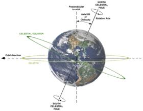
Earth's rotation period relative to the Sun—its mean solar day—is 86,400 seconds of mean solar time (86,400.0025 SI seconds).[128] As the Earth's solar day is now slightly longer than it was during the 19th century because of tidal acceleration, each day varies between 0 and 2 SI ms longer.[129][130]
Earth's rotation period relative to the fixed stars, called its stellar day by the International Earth Rotation and Reference Systems Service (IERS), is 86164.098903691 seconds of mean solar time (UT1), or 23h 56m 4.098903691s.[2][note 13] Earth's rotation period relative to the precessing or moving mean vernal equinox, misnamed its sidereal day, is 86164.09053083288 seconds of mean solar time (UT1) (23h 56m 4.09053083288s).[2] Thus the sidereal day is shorter than the stellar day by about 8.4 ms.[131] The length of the mean solar day in SI seconds is available from the IERS for the periods 1623–2005[132] and 1962–2005.[133]
Apart from meteors within the atmosphere and low-orbiting satellites, the main apparent motion of celestial bodies in the Earth's sky is to the west at a rate of 15°/h = 15'/min. For bodies near the celestial equator, this is equivalent to an apparent diameter of the Sun or Moon every two minutes; from the planet's surface, the apparent sizes of the Sun and the Moon are approximately the same.[134][135]
Orbit
Main article: Earth's orbitEarth orbits the Sun at an average distance of about 150 million kilometers every 365.2564 mean solar days, or one sidereal year. From Earth, this gives an apparent movement of the Sun eastward with respect to the stars at a rate of about 1°/day, or a Sun or Moon diameter, every 12 hours. Because of this motion, on average it takes 24 hours—a solar day—for Earth to complete a full rotation about its axis so that the Sun returns to the meridian. The orbital speed of the Earth averages about 29.8 km/s (107,000 km/h), which is fast enough to cover the planet's diameter (about 12,600 km) in seven minutes, and the distance to the Moon (384,000 km) in four hours.[3]
The Moon revolves with the Earth around a common barycenter every 27.32 days relative to the background stars. When combined with the Earth–Moon system's common revolution around the Sun, the period of the synodic month, from new moon to new moon, is 29.53 days. Viewed from the celestial north pole, the motion of Earth, the Moon and their axial rotations are all counter-clockwise. Viewed from a vantage point above the north poles of both the Sun and the Earth, the Earth appears to revolve in a counterclockwise direction about the Sun. The orbital and axial planes are not precisely aligned: Earth's axis is tilted some 23.4 degrees from the perpendicular to the Earth–Sun plane, and the Earth–Moon plane is tilted about 5 degrees against the Earth-Sun plane. Without this tilt, there would be an eclipse every two weeks, alternating between lunar eclipses and solar eclipses.[3][136]
The Hill sphere, or gravitational sphere of influence, of the Earth is about 1.5 Gm (or 1,500,000 kilometers) in radius.[137][note 14] This is maximum distance at which the Earth's gravitational influence is stronger than the more distant Sun and planets. Objects must orbit the Earth within this radius, or they can become unbound by the gravitational perturbation of the Sun.
 Illustration of the Milky Way Galaxy, showing the location of the Sun
Earth, along with the Solar System, is situated in the Milky Way galaxy, orbiting about 28,000 light years from the center of the galaxy. It is currently about 20 light years above the galaxy's equatorial plane in the Orion spiral arm.[138]
Axial tilt and seasons
Main article: Axial tiltBecause of the axial tilt of the Earth, the amount of sunlight reaching any given point on the surface varies over the course of the year. This results in seasonal change in climate, with summer in the northern hemisphere occurring when the North Pole is pointing toward the Sun, and winter taking place when the pole is pointed away. During the summer, the day lasts longer and the Sun climbs higher in the sky. In winter, the climate becomes generally cooler and the days shorter. Above the Arctic Circle, an extreme case is reached where there is no daylight at all for part of the year—a polar night. In the southern hemisphere the situation is exactly reversed, with the South Pole oriented opposite the direction of the North Pole.
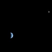 Earth and Moon from Mars, imaged by Mars Reconnaissance Orbiter. From space, the Earth can be seen to go through phases similar to the phases of the Moon.
By astronomical convention, the four seasons are determined by the solstices—the point in the orbit of maximum axial tilt toward or away from the Sun—and the equinoxes, when the direction of the tilt and the direction to the Sun are perpendicular. In the northern hemisphere, Winter Solstice occurs on about December 21, Summer Solstice is near June 21, Spring Equinox is around March 20 and Autumnal Equinox is about September 23. In the Southern hemisphere, the situation is reversed, with the Summer and Winter Solstices exchanged and the Spring and Autumnal Equinox dates switched.[139]
The angle of the Earth's tilt is relatively stable over long periods of time. The tilt does undergo nutation; a slight, irregular motion with a main period of 18.6 years.[140] The orientation (rather than the angle) of the Earth's axis also changes over time, precessing around in a complete circle over each 25,800 year cycle; this precession is the reason for the difference between a sidereal year and a tropical year. Both of these motions are caused by the varying attraction of the Sun and Moon on the Earth's equatorial bulge. From the perspective of the Earth, the poles also migrate a few meters across the surface. This polar motion has multiple, cyclical components, which collectively are termed quasiperiodic motion. In addition to an annual component to this motion, there is a 14-month cycle called the Chandler wobble. The rotational velocity of the Earth also varies in a phenomenon known as length of day variation.[141]
In modern times, Earth's perihelion occurs around January 3, and the aphelion around July 4. These dates change over time due to precession and other orbital factors, which follow cyclical patterns known as Milankovitch cycles. The changing Earth-Sun distance results in an increase of about 6.9%[note 15] in solar energy reaching the Earth at perihelion relative to aphelion. Since the southern hemisphere is tilted toward the Sun at about the same time that the Earth reaches the closest approach to the Sun, the southern hemisphere receives slightly more energy from the Sun than does the northern over the course of a year. This effect is much less significant than the total energy change due to the axial tilt, and most of the excess energy is absorbed by the higher proportion of water in the southern hemisphere.[142]
Moon
Characteristics Diameter 3,474.8 km Mass 7.349×10²² kg Semi-major axis 384,400 km Orbital period 27 d 7 h 43.7 m Main article: MoonThe Moon is a relatively large, terrestrial, planet-like satellite, with a diameter about one-quarter of the Earth's. It is the largest moon in the Solar System relative to the size of its planet, although Charon is larger relative to the dwarf planet Pluto. The natural satellites orbiting other planets are called "moons" after Earth's Moon.
The gravitational attraction between the Earth and Moon causes tides on Earth. The same effect on the Moon has led to its tidal locking: its rotation period is the same as the time it takes to orbit the Earth. As a result, it always presents the same face to the planet. As the Moon orbits Earth, different parts of its face are illuminated by the Sun, leading to the lunar phases; the dark part of the face is separated from the light part by the solar terminator.
Because of their tidal interaction, the Moon recedes from Earth at the rate of approximately 38 mm a year. Over millions of years, these tiny modifications—and the lengthening of Earth's day by about 23 µs a year—add up to significant changes.[143] During the Devonian period, for example, (approximately 410 million years ago) there were 400 days in a year, with each day lasting 21.8 hours.[144]
 Details of the Earth-Moon system. Besides the radius of each object, the radius to the Earth-Moon barycenter is shown. Photos from NASA. Data from NASA. The Moon's axis is located by Cassini's third law.
The Moon may have dramatically affected the development of life by moderating the planet's climate. Paleontological evidence and computer simulations show that Earth's axial tilt is stabilized by tidal interactions with the Moon.[145] Some theorists believe that without this stabilization against the torques applied by the Sun and planets to the Earth's equatorial bulge, the rotational axis might be chaotically unstable, exhibiting chaotic changes over millions of years, as appears to be the case for Mars.[146]
Viewed from Earth, the Moon is just far enough away to have very nearly the same apparent-sized disk as the Sun. The angular size (or solid angle) of these two bodies match because, although the Sun's diameter is about 400 times as large as the Moon's, it is also 400 times more distant.[135] This allows total and annular solar eclipses to occur on Earth.
The most widely accepted theory of the Moon's origin, the giant impact theory, states that it formed from the collision of a Mars-size protoplanet called Theia with the early Earth. This hypothesis explains (among other things) the Moon's relative lack of iron and volatile elements, and the fact that its composition is nearly identical to that of the Earth's crust.[147]
Earth has at least five co-orbital asteroids, including 3753 Cruithne and 2002 AA29.[148][149] As of 2011, there are 931 operational, man-made satellites orbiting the Earth.[150] On July 27, 2011, astronomers reported a trojan asteroid companion, 2010 TK7, librating around the leading Lagrange triangular point, L4, of Earth in Earth's orbit around the Sun.[151][152]
 A scale representation of the relative sizes of, and average distance between, Earth and Moon
Habitability
See also: Planetary habitabilityA planet that can sustain life is termed habitable, even if life did not originate there. The Earth provides liquid water—an environment where complex organic molecules can assemble and interact, and sufficient energy to sustain metabolism.[153] The distance of the Earth from the Sun, as well as its orbital eccentricity, rate of rotation, axial tilt, geological history, sustaining atmosphere and protective magnetic field all contribute to the current climactic conditions at the surface.[154]
Biosphere
Main article: BiosphereThe planet's life forms are sometimes said to form a "biosphere". This biosphere is generally believed to have begun evolving about 3.5 billion years ago. The biosphere is divided into a number of biomes, inhabited by broadly similar plants and animals. On land, biomes are separated primarily by differences in latitude, height above sea level and humidity. Terrestrial biomes lying within the Arctic or Antarctic Circles, at high altitudes or in extremely arid areas are relatively barren of plant and animal life; species diversity reaches a peak in humid lowlands at equatorial latitudes.[155]
Natural resources and land use
Main article: Natural resourceThe Earth provides resources that are exploitable by humans for useful purposes. Some of these are non-renewable resources, such as mineral fuels, that are difficult to replenish on a short time scale.
Large deposits of fossil fuels are obtained from the Earth's crust, consisting of coal, petroleum, natural gas and methane clathrate. These deposits are used by humans both for energy production and as feedstock for chemical production. Mineral ore bodies have also been formed in Earth's crust through a process of Ore genesis, resulting from actions of erosion and plate tectonics.[156] These bodies form concentrated sources for many metals and other useful elements.
The Earth's biosphere produces many useful biological products for humans, including (but far from limited to) food, wood, pharmaceuticals, oxygen, and the recycling of many organic wastes. The land-based ecosystem depends upon topsoil and fresh water, and the oceanic ecosystem depends upon dissolved nutrients washed down from the land.[157] Humans also live on the land by using building materials to construct shelters. In 1993, human use of land is approximately:
Land use Arable land Permanent crops Permanent pastures Forests and woodland Urban areas Other Percentage 13.13%[13] 4.71%[13] 26% 32% 1.5% 30% The estimated amount of irrigated land in 1993 was 2,481,250 km2.[13]
Natural and environmental hazards
Large areas of the Earth's surface are subject to extreme weather such as tropical cyclones, hurricanes, or typhoons that dominate life in those areas. From 1980–2000, these events caused an average of 11,800 deaths per year.[158] Many places are subject to earthquakes, landslides, tsunamis, volcanic eruptions, tornadoes, sinkholes, blizzards, floods, droughts, wildfires, and other calamities and disasters.
Many localized areas are subject to human-made pollution of the air and water, acid rain and toxic substances, loss of vegetation (overgrazing, deforestation, desertification), loss of wildlife, species extinction, soil degradation, soil depletion, erosion, and introduction of invasive species.
According to the United Nations, a scientific consensus exists linking human activities to global warming due to industrial carbon dioxide emissions. This is predicted to produce changes such as the melting of glaciers and ice sheets, more extreme temperature ranges, significant changes in weather and a global rise in average sea levels.[159]
Human geography
Main article: Human geographySee also: WorldCartography, the study and practice of map making, and vicariously geography, have historically been the disciplines devoted to depicting the Earth. Surveying, the determination of locations and distances, and to a lesser extent navigation, the determination of position and direction, have developed alongside cartography and geography, providing and suitably quantifying the requisite information.
Earth has reached approximately 7,000,000,000 human inhabitants as of October 31, 2011.[160] Projections indicate that the world's human population will reach 9.2 billion in 2050.[161] Most of the growth is expected to take place in developing nations. Human population density varies widely around the world, but a majority live in Asia. By 2020, 60% of the world's population is expected to be living in urban, rather than rural, areas.[162]
It is estimated that only one-eighth of the surface of the Earth is suitable for humans to live on—three-quarters is covered by oceans, and half of the land area is either desert (14%),[163] high mountains (27%),[164] or other less suitable terrain. The northernmost permanent settlement in the world is Alert, on Ellesmere Island in Nunavut, Canada.[165] (82°28′N) The southernmost is the Amundsen-Scott South Pole Station, in Antarctica, almost exactly at the South Pole. (90°S)
Independent sovereign nations claim the planet's entire land surface, except for some parts of Antarctica and the odd unclaimed area of Bir Tawil between Egypt and Sudan. As of 2011 there are 204 sovereign states, including the 193 United Nations member states. In addition, there are 59 dependent territories, and a number of autonomous areas, territories under dispute and other entities.[13] Historically, Earth has never had a sovereign government with authority over the entire globe, although a number of nation-states have striven for world domination and failed.[166]
The United Nations is a worldwide intergovernmental organization that was created with the goal of intervening in the disputes between nations, thereby avoiding armed conflict.[167] The U.N. serves primarily as a forum for international diplomacy and international law. When the consensus of the membership permits, it provides a mechanism for armed intervention.[168]
The first human to orbit the Earth was Yuri Gagarin on April 12, 1961.[169] In total, about 400 people visited outer space and reached Earth orbit as of 2004, and, of these, twelve have walked on the Moon.[170][171][172] Normally the only humans in space are those on the International Space Station. The station's crew, currently six people, is usually replaced every six months.[173] The furthest humans have travelled from Earth is 400,171 km, achieved during the 1970 Apollo 13 mission.[174]
 The 7 continents of Earth:[175] North America , South America, Antarctica, Africa, Europe, Asia, Australia
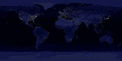 The Earth at night, a composite of DMSP/OLS ground illumination data on a simulated night-time image of the world. This image is not photographic and many features are brighter than they would appear to a direct observer.ISS video beginning just south-east of Alaska. The first city that the ISS passes over (seen approximately 10 seconds into the video) is San Francisco and the surrounding areas. If one looks very carefully, you can spot where the Golden Gate Bridge is located: a smaller strip of lights just before the city of San Francisco, nearest to the clouds on the right of the image. Very obvious lightning storms can be seen on the Pacific Ocean coastline, with clouds overhead. As the video continues, the ISS passes over Central America (green lights can be seen here), with the Yucatan Peninsula on the left. The pass ends as the ISS is over the capital city of Bolivia, La Paz.
Cultural viewpoint
Main articles: Earth in culture and Etymology of the word "Earth"The name "Earth" derives from the Anglo-Saxon word erda, which means ground or soil, and is related to the German word Erde. It became eorthe later, and then erthe in Middle English.[176] The standard astronomical symbol of the Earth consists of a cross circumscribed by a circle.[177]
Unlike the rest of the planets in the Solar System, humankind did not begin to view the Earth as a moving object in orbit around the Sun until the 16th century.[178] Earth has often been personified as a deity, in particular a goddess. In many cultures the mother goddess is also portrayed as a fertility deity. Creation myths in many religions recall a story involving the creation of the Earth by a supernatural deity or deities. A variety of religious groups, often associated with fundamentalist branches of Protestantism[179] or Islam,[180] assert that their interpretations of these creation myths in sacred texts are literal truth and should be considered alongside or replace conventional scientific accounts of the formation of the Earth and the origin and development of life.[181] Such assertions are opposed by the scientific community[182][183] and by other religious groups.[184][185][186] A prominent example is the creation-evolution controversy.
In the past there were varying levels of belief in a flat Earth,[187] but this was displaced by the concept of a spherical Earth due to observation and circumnavigation.[188] The human perspective regarding the Earth has changed following the advent of spaceflight, and the biosphere is now widely viewed from a globally integrated perspective.[189][190] This is reflected in a growing environmental movement that is concerned about humankind's effects on the planet.[191]
See also
 Earth sciences portal
Notes
- ^ All astronomical quantities vary, both secularly and periodically. The quantities given are the values at the instant J2000.0 of the secular variation, ignoring all periodic variations.
- ^ a b aphelion = a × (1 + e); perihelion = a × (1 - e), where a is the semi-major axis and e is the eccentricity.
- ^ The reference lists the longitude of the ascending node as -11.26064°, which is equivalent to 348.73936° by the fact that any angle is equal to itself plus 360°.
- ^ The reference lists the longitude of perihelion, which is the sum of the longitude of the ascending node and the argument of perihelion. That is, 114.20783° + (-11.26064°) = 102.94719°.
- ^ Due to natural fluctuations, ambiguities surrounding ice shelves, and mapping conventions for vertical datums, exact values for land and ocean coverage are not meaningful. Based on data from the Vector Map and Global Landcover datasets, extreme values for coverage of lakes and streams are 0.6% and 1.0% of the Earth's surface. The ice shields of Antarctica and Greenland are counted as land, even though much of the rock which supports them lies below sea level.
- ^ By International Astronomical Union convention, the term terra is used only for naming extensive land masses on celestial bodies other than the Earth. Cf. Blue, Jennifer (2007-07-05). "Descriptor Terms (Feature Types)". Gazetteer of Planetary Nomenclature. USGS. http://planetarynames.wr.usgs.gov/jsp/append5.jsp. Retrieved 2007-07-05.
- ^ The number of solar days is one less than the number of sidereal days because the orbital motion of the Earth about the Sun results in one additional revolution of the planet about its axis.
- ^ Locally varies between 5 and 200 km.
- ^ Locally varies between 5 and 70 km.
- ^ Including the Somali Plate, which is currently in the process of formation out of the African Plate. See: Chorowicz, Jean (October 2005). "The East African rift system". Journal of African Earth Sciences 43 (1–3): 379–410. Bibcode 2005JAfES..43..379C. doi:10.1016/j.jafrearsci.2005.07.019.
- ^ This is the measurement taken by the vessel Kaikō in March 1995 and is believed to be the most accurate measurement to date. See the Challenger Deep article for more details.
- ^ The total surface area of the Earth is 5.1×10⁸ km2. To first approximation, the average depth would be the ratio of the two, or 2.7 km.
- ^ Aoki, the ultimate source of these figures, uses the term "seconds of UT1" instead of "seconds of mean solar time".—Aoki, S. (1982). "The new definition of universal time". Astronomy and Astrophysics 105 (2): 359–361. Bibcode 1982A&A...105..359A.
- ^ For the Earth, the Hill radius is
 ,
,
 .
. - ^ Aphelion is 103.4% of the distance to perihelion. Due to the inverse square law, the radiation at perihelion is about 106.9% the energy at aphelion.
References
- ^ a b Standish, E. Myles; Williams, James C.. "Orbital Ephemerides of the Sun, Moon, and Planets" (PDF). International Astronomical Union Commission 4: (Ephemerides). http://iau-comm4.jpl.nasa.gov/XSChap8.pdf. Retrieved 2010-04-03. See table 8.10.2. Calculation based upon 1 AU = 149,597,870,700(3) m.
- ^ a b c d Staff (2007-08-07). "Useful Constants". International Earth Rotation and Reference Systems Service. http://hpiers.obspm.fr/eop-pc/models/constants.html. Retrieved 2008-09-23.
- ^ a b c d e f g h i j k l m n Williams, David R. (2004-09-01). "Earth Fact Sheet". NASA. http://nssdc.gsfc.nasa.gov/planetary/factsheet/earthfact.html. Retrieved 2010-08-09.
- ^ Allen, Clabon Walter; Cox, Arthur N. (2000). Allen's Astrophysical Quantities. Springer. p. 294. ISBN 0-387-98746-0. http://books.google.com/?id=w8PK2XFLLH8C&pg=PA294. Retrieved 2011-03-13.
- ^ US Space Command (March 1, 2001). "Reentry Assessment - US Space Command Fact Sheet". SpaceRef Interactive. http://www.spaceref.com/news/viewpr.html?pid=4008. Retrieved 2011-05-07.
- ^ Various (2000). David R. Lide. ed. Handbook of Chemistry and Physics (81st ed.). CRC. ISBN 0-8493-0481-4.
- ^ "Selected Astronomical Constants, 2011". The Astronomical Almanac. http://asa.usno.navy.mil/SecK/2011/Astronomical_Constants_2011.txt. Retrieved 2011-02-25.
- ^ a b World Geodetic System (WGS-84). Available online from National Geospatial-Intelligence Agency.
- ^ IERS Working Groups (2003). "General Definitions and Numerical Standards". In McCarthy, Dennis D.; Petit, Gérard. IERS Technical Note No. 32. U.S. Naval Observatory and Bureau International des Poids et Mesures. http://www.iers.org/MainDisp.csl?pid=46-25776. Retrieved 2008-08-03.
- ^ Humerfelt, Sigurd (October 26, 2010). "How WGS 84 defines Earth". http://home.online.no/~sigurdhu/WGS84_Eng.html. Retrieved 2011-04-29.
- ^ Pidwirny, Michael (2006-02-02). Surface area of our planet covered by oceans and continents.(Table 8o-1). University of British Columbia, Okanagan. http://www.physicalgeography.net/fundamentals/8o.html. Retrieved 2007-11-26.
- ^ a b c d e f Staff (2008-07-24). "World". The World Factbook. Central Intelligence Agency. https://www.cia.gov/library/publications/the-world-factbook/geos/xx.html. Retrieved 2008-08-05.
- ^ Yoder, Charles F. (1995). T. J. Ahrens. ed. Global Earth Physics: A Handbook of Physical Constants. Washington: American Geophysical Union. p. 12. ISBN 0-87590-851-9. Archived from the original on 2007-03-08. http://replay.waybackmachine.org/20090421092502/http://www.agu.org/reference/gephys.html. Retrieved 2007-03-17.
- ^ Allen, Clabon Walter; Cox, Arthur N. (2000). Allen's Astrophysical Quantities. Springer. p. 296. ISBN 0-387-98746-0. http://books.google.com/?id=w8PK2XFLLH8C&pg=PA296. Retrieved 2010-08-17.
- ^ Arthur N. Cox, ed (2000). Allen's Astrophysical Quantities (4th ed.). New York: AIP Press. p. 244. ISBN 0-387-98746-0. http://books.google.com/?id=w8PK2XFLLH8C&pg=PA244. Retrieved 2010-08-17.
- ^ "World: Lowest Temperature". WMO Weather and Climate Extremes Archive. Arizona State University. http://wmo.asu.edu/world-lowest-temperature. Retrieved 2010-08-07.
- ^ Kinver, Mark (December 10, 2009). "Global average temperature may hit record level in 2010". BBC Online. http://news.bbc.co.uk/2/hi/science/nature/8406839.stm. Retrieved 2010-04-22.
- ^ "World: Highest Temperature". WMO Weather and Climate Extremes Archive. Arizona State University. http://wmo.asu.edu/world-highest-temperature. Retrieved 2010-08-07.
- ^ Drinkwater, Mark; Kerr, Yann; Font, Jordi; Berger, Michael (February 2009). "Exploring the Water Cycle of the ‘Blue Planet’: The Soil Moisture and Ocean Salinity (SMOS) mission". ESA Bulletin (European Space Agency) (137): 6–15. http://www.esa.int/esapub/bulletin/bulletin137/bul137b_drinkwater.pdf. "A view of Earth, the ‘Blue Planet’ [...] When astronauts first went into the space, they looked back at our Earth for the first time, and called our home the ‘Blue Planet’."
- ^ a b See:
- Dalrymple, G.B. (1991). The Age of the Earth. California: Stanford University Press. ISBN 0-8047-1569-6.
- Newman, William L. (2007-07-09). "Age of the Earth". Publications Services, USGS. http://pubs.usgs.gov/gip/geotime/age.html. Retrieved 2007-09-20.
- Dalrymple, G. Brent (2001). "The age of the Earth in the twentieth century: a problem (mostly) solved". Geological Society, London, Special Publications 190 (1): 205–221. doi:10.1144/GSL.SP.2001.190.01.14. http://sp.lyellcollection.org/cgi/content/abstract/190/1/205. Retrieved 2007-09-20.
- Stassen, Chris (2005-09-10). "The Age of the Earth". TalkOrigins Archive. http://www.talkorigins.org/faqs/faq-age-of-earth.html. Retrieved 2008-12-30.
- ^ May, Robert M. (1988). "How many species are there on earth?". Science 241 (4872): 1441–1449. Bibcode 1988Sci...241.1441M. doi:10.1126/science.241.4872.1441. PMID 17790039.
- ^ Harrison, Roy M.; Hester, Ronald E. (2002). Causes and Environmental Implications of Increased UV-B Radiation. Royal Society of Chemistry. ISBN 0-85404-265-2.
- ^ a b c Britt, Robert (2000-02-25). "Freeze, Fry or Dry: How Long Has the Earth Got?". http://replay.waybackmachine.org/20090605231345/http://www.space.com/scienceastronomy/solarsystem/death_of_earth_000224.html.
- ^ a b Carrington, Damian (2000-02-21). "Date set for desert Earth". BBC News. http://news.bbc.co.uk/1/hi/sci/tech/specials/washington_2000/649913.stm. Retrieved 2007-03-31.
- ^ Yoder, Charles F. (1995). T. J. Ahrens. ed. Global Earth Physics: A Handbook of Physical Constants. Washington: American Geophysical Union. p. 8. ISBN 0-87590-851-9. http://replay.waybackmachine.org/20090421092502/http://www.agu.org/reference/gephys.html. Retrieved 2007-03-17.
- ^ United States Census Bureau (2 November 2011). "World POP Clock Projection". United States Census Bureau International Database. http://www.census.gov/population/popclockworld.html. Retrieved 2011-11-02.
- ^ Bowring, S.; Housh, T. (1995). "The Earth's early evolution". Science 269 (5230): 1535. Bibcode 1995Sci...269.1535B. doi:10.1126/science.7667634. PMID 7667634.
- ^ Yin, Qingzhu; Jacobsen, S. B.; Yamashita, K.; Blichert-Toft, J.; Télouk, P.; Albarède, F. (2002). "A short timescale for terrestrial planet formation from Hf-W chronometry of meteorites". Nature 418 (6901): 949–952. Bibcode 2002Natur.418..949Y. doi:10.1038/nature00995. PMID 12198540.
- ^ Kleine, Thorsten; Palme, Herbert; Mezger, Klaus; Halliday, Alex N. (2005-11-24). "Hf-W Chronometry of Lunar Metals and the Age and Early Differentiation of the Moon". Science 310 (5754): 1671–1674. Bibcode 2005Sci...310.1671K. doi:10.1126/science.1118842. PMID 16308422.
- ^ Reilly, Michael (October 22, 2009). "Controversial Moon Origin Theory Rewrites History". http://news.discovery.com/space/moon-earth-formation.html. Retrieved 2010-01-30.
- ^ Canup, R. M.; Asphaug, E. (Fall Meeting 2001). "An impact origin of the Earth-Moon system". Abstract #U51A-02. American Geophysical Union. Bibcode 2001AGUFM.U51A..02C.
- ^ Canup, R.; Asphaug, E. (2001). "Origin of the Moon in a giant impact near the end of the Earth's formation". Nature 412 (6848): 708–712. Bibcode 2001Natur.412..708C. doi:10.1038/35089010. PMID 11507633. http://www.nature.com/nature/journal/v412/n6848/abs/412708a0.html.
- ^ Morbidelli, A. et al. (2000). "Source regions and time scales for the delivery of water to Earth". Meteoritics & Planetary Science 35 (6): 1309–1320. Bibcode 2000M&PS...35.1309M. doi:10.1111/j.1945-5100.2000.tb01518.x.
- ^ Guinan, E. F.; Ribas, I.. "Our Changing Sun: The Role of Solar Nuclear Evolution and Magnetic Activity on Earth's Atmosphere and Climate". In Benjamin Montesinos, Alvaro Gimenez and Edward F. Guinan. ASP Conference Proceedings: The Evolving Sun and its Influence on Planetary Environments. San Francisco: Astronomical Society of the Pacific. Bibcode 2002ASPC..269...85G. ISBN 1-58381-109-5.
- ^ Staff (March 4, 2010). "Oldest measurement of Earth's magnetic field reveals battle between Sun and Earth for our atmosphere". Physorg.news. http://www.physorg.com/news186922627.html. Retrieved 2010-03-27.
- ^ Rogers, John James William; Santosh, M. (2004). Continents and Supercontinents. Oxford University Press US. p. 48. ISBN 0-19-516589-6.
- ^ Hurley, P. M. (Jun 1969). "Pre-drift continental nuclei". Science 164 (3885): 1229–1242. Bibcode 1969Sci...164.1229H. doi:10.1126/science.164.3885.1229. PMID 17772560.
- ^ Armstrong, R. L. (1968). "A model for the evolution of strontium and lead isotopes in a dynamic earth". Reviews of Geophysics 6 (2): 175–199. Bibcode 1968RvGSP...6..175A. doi:10.1029/RG006i002p00175.
- ^ De Smet, J. (2000). "Early formation and long-term stability of continents resulting from decompression melting in a convecting mantle". Tectonophysics 322 (1-2): 19. Bibcode 2000Tectp.322...19D. doi:10.1016/S0040-1951(00)00055-X.
- ^ Harrison, T. et al. (December 2005). "Heterogeneous Hadean hafnium: evidence of continental crust at 4.4 to 4.5 ga". Science 310 (5756): 1947–50. Bibcode 2005Sci...310.1947H. doi:10.1126/science.1117926. PMID 16293721.
- ^ Hong, D. (2004). "Continental crustal growth and the supercontinental cycle: evidence from the Central Asian Orogenic Belt". Journal of Asian Earth Sciences 23 (5): 799. Bibcode 2004JAESc..23..799H. doi:10.1016/S1367-9120(03)00134-2.
- ^ Armstrong, R. L. (1991). "The persistent myth of crustal growth". Australian Journal of Earth Sciences 38 (5): 613–630. Bibcode 1991AuJES..38..613A. doi:10.1080/08120099108727995.
- ^ Murphy, J. B.; Nance, R. D. (1965). "How do supercontinents assemble?". American Scientist 92 (4): 324–33. doi:10.1511/2004.4.324. http://scienceweek.com/2004/sa040730-5.htm. Retrieved 2007-03-05.
- ^ Doolittle, W. Ford; Worm, Boris (February 2000). "Uprooting the tree of life". Scientific American 282 (6): 90–95. doi:10.1038/scientificamerican0200-90. http://shiva.msu.montana.edu/courses/mb437_537_2005_fall/docs/uprooting.pdf.
- ^ Berkner, L. V.; Marshall, L. C. (1965). "On the Origin and Rise of Oxygen Concentration in the Earth's Atmosphere". Journal of Atmospheric Sciences 22 (3): 225–261. Bibcode 1965JAtS...22..225B. doi:10.1175/1520-0469(1965)022<0225:OTOARO>2.0.CO;2.
- ^ Burton, Kathleen (2002-11-29). "Astrobiologists Find Evidence of Early Life on Land". NASA. http://www.nasa.gov/centers/ames/news/releases/2000/00_79AR.html. Retrieved 2007-03-05.
- ^ Kirschvink, J. L. (1992). Schopf, J.W.; Klein, C. and Des Maris, D. ed. Late Proterozoic low-latitude global glaciation: the Snowball Earth. The Proterozoic Biosphere: A Multidisciplinary Study. Cambridge University Press. pp. 51–52. ISBN 0-521-36615-1.
- ^ Raup, D. M.; Sepkoski, J. J. (1982). "Mass Extinctions in the Marine Fossil Record". Science 215 (4539): 1501–1503. Bibcode 1982Sci...215.1501R. doi:10.1126/science.215.4539.1501. PMID 17788674.
- ^ Gould, Stephan J. (October 1994). "The Evolution of Life on Earth". Scientific American. http://brembs.net/gould.html. Retrieved 2007-03-05.
- ^ Wilkinson, B. H.; McElroy, B. J. (2007). "The impact of humans on continental erosion and sedimentation". Bulletin of the Geological Society of America 119 (1–2): 140–156. doi:10.1130/B25899.1. http://bulletin.geoscienceworld.org/cgi/content/abstract/119/1-2/140. Retrieved 2007-04-22.
- ^ Staff. "Paleoclimatology – The Study of Ancient Climates". Page Paleontology Science Center. http://www.lakepowell.net/sciencecenter/paleoclimate.htm. Retrieved 2007-03-02.
- ^ a b c Sackmann, I.-J.; Boothroyd, A. I.; Kraemer, K. E. (1993). "Our Sun. III. Present and Future". Astrophysical Journal 418: 457–468. Bibcode 1993ApJ...418..457S. doi:10.1086/173407.
- ^ Kasting, J.F. (1988). "Runaway and Moist Greenhouse Atmospheres and the Evolution of Earth and Venus". Icarus 74 (3): 472–494. Bibcode 1988Icar...74..472K. doi:10.1016/0019-1035(88)90116-9. PMID 11538226.
- ^ a b Ward, Peter D.; Brownlee, Donald (2002). The Life and Death of Planet Earth: How the New Science of Astrobiology Charts the Ultimate Fate of Our World. New York: Times Books, Henry Holt and Company. ISBN 0-8050-6781-7.
- ^ Li, King-Fai; Pahlevan, Kaveh; Kirschvink, Joseph L.; Yung, Yuk L. (2009). "Atmospheric Pressure as a Natural Climate Regulator for a Terrestrial Planet with a Biosphere". Proceedings of the National Academy of Sciences 1–6 (24): 9576–9579. Bibcode 2009PNAS..106.9576L. doi:10.1073/pnas.0809436106. PMC 2701016. PMID 19487662. http://www.gps.caltech.edu/~kfl/paper/Li_PNAS2009.pdf. Retrieved 2009-07-19.
- ^ Guillemot, H.; Greffoz, V. (March 2002). "Ce que sera la fin du monde" (in French). Science et Vie N° 1014.
- ^ Bounama, Christine; Franck, S.; Von Bloh, W. (2001). "The fate of Earth's ocean". Hydrology and Earth System Sciences (Germany: Potsdam Institute for Climate Impact Research) 5 (4): 569–575. Bibcode 2001HESS....5..569B. doi:10.5194/hess-5-569-2001. http://www.hydrol-earth-syst-sci.net/5/569/2001/hess-5-569-2001.pdf. Retrieved 2009-07-03.
- ^ a b Schröder, K.-P.; Connon Smith, Robert (2008). "Distant future of the Sun and Earth revisited". Monthly Notices of the Royal Astronomical Society 386 (1): 155. arXiv:0801.4031. Bibcode 2008MNRAS.386..155S. doi:10.1111/j.1365-2966.2008.13022.x.
See also Palmer, Jason (2008-02-22). "Hope dims that Earth will survive Sun's death". NewScientist.com news service. http://space.newscientist.com/article/dn13369-hope-dims-that-earth-will-survive-suns-death.html?feedId=online-news_rss20. Retrieved 2008-03-24. - ^ Stern, David P. (2001-11-25). "Planetary Magnetism". NASA. http://astrogeology.usgs.gov/HotTopics/index.php?/archives/147-Names-for-the-Columbia-astronauts-provisionally-approved.html. Retrieved 2007-04-01.
- ^ Tackley, Paul J. (2000-06-16). "Mantle Convection and Plate Tectonics: Toward an Integrated Physical and Chemical Theory". Science 288 (5473): 2002–2007. Bibcode 2000Sci...288.2002T. doi:10.1126/science.288.5473.2002. PMID 10856206.
- ^ The 'Highest' Spot on Earth
- ^ Milbert, D. G.; Smith, D. A. "Converting GPS Height into NAVD88 Elevation with the GEOID96 Geoid Height Model". National Geodetic Survey, NOAA. http://www.ngs.noaa.gov/PUBS_LIB/gislis96.html. Retrieved 2007-03-07.
- ^ a b Sandwell, D. T.; Smith, W. H. F. (2006-07-07). "Exploring the Ocean Basins with Satellite Altimeter Data". NOAA/NGDC. http://www.ngdc.noaa.gov/mgg/bathymetry/predicted/explore.HTML. Retrieved 2007-04-21.
- ^ The 'Highest' Spot on Earth? NPR.org Consultado el 25-07-2010
- ^ Mohr, P. J.; Taylor, B. N. (October 2000). "Unit of length (meter)". NIST Reference on Constants, Units, and Uncertainty. NIST Physics Laboratory. http://physics.nist.gov/cuu/Units/meter.html. Retrieved 2007-04-23.
- ^ Staff (November 2001). "WPA Tournament Table & Equipment Specifications". World Pool-Billiards Association. http://www.wpa-pool.com/index.asp?content=rules_spec. Retrieved 2007-03-10.
- ^ Senne, Joseph H. (2000). "Did Edmund Hillary Climb the Wrong Mountain". Professional Surveyor 20 (5): 16–21.
- ^ Sharp, David (2005-03-05). "Chimborazo and the old kilogram". The Lancet 365 (9462): 831–832. doi:10.1016/S0140-6736(05)71021-7. PMID 15752514.
- ^ "Tall Tales about Highest Peaks". Australian Broadcasting Corporation. http://www.abc.net.au/science/k2/moments/s1086384.htm. Retrieved 2008-12-29.
- ^ Brown, Geoff C.; Mussett, Alan E. (1981). The Inaccessible Earth (2nd ed.). Taylor & Francis. p. 166. ISBN 0-04-550028-2. Note: After Ronov and Yaroshevsky (1969).
- ^ Morgan, J. W.; Anders, E. (1980). "Chemical composition of Earth, Venus, and Mercury". Proceedings of the National Academy of Science 77 (12): 6973–6977. Bibcode 1980PNAS...77.6973M. doi:10.1073/pnas.77.12.6973. PMC 350422. PMID 16592930. http://www.pubmedcentral.nih.gov/articlerender.fcgi?tool=pmcentrez&artid=350422.
- ^
 This article incorporates text from a publication now in the public domain: Chisholm, Hugh, ed (1911). "Petrology". Encyclopædia Britannica (11th ed.). Cambridge University Press.
 - ^ Tanimoto, Toshiro (1995). Thomas J. Ahrens. ed (PDF). Crustal Structure of the Earth. Washington, DC: American Geophysical Union. ISBN 0-87590-851-9. Archived from the original on 2006-10-16. http://web.archive.org/web/20061016194153/http://www.agu.org/reference/gephys/15_tanimoto.pdf. Retrieved 2007-02-03.
- ^ Kerr, Richard A. (2005-09-26). "Earth's Inner Core Is Running a Tad Faster Than the Rest of the Planet". Science 309 (5739): 1313. doi:10.1126/science.309.5739.1313a. PMID 16123276.
- ^ Jordan, T. H. (1979). "Structural Geology of the Earth's Interior". Proceedings National Academy of Science 76 (9): 4192–4200. Bibcode 1979PNAS...76.4192J. doi:10.1073/pnas.76.9.4192. PMC 411539. PMID 16592703. http://www.pubmedcentral.nih.gov/articlerender.fcgi?tool=pmcentrez&artid=411539.
- ^ Robertson, Eugene C. (2001-07-26). "The Interior of the Earth". USGS. http://pubs.usgs.gov/gip/interior/. Retrieved 2007-03-24.
- ^ a b Turcotte, D. L.; Schubert, G. (2002). "4". Geodynamics (2 ed.). Cambridge, England, UK: Cambridge University Press. pp. 136–137. ISBN 978-0-521-66624-4.
- ^ Sanders, Robert (2003-12-10). "Radioactive potassium may be major heat source in Earth's core". UC Berkeley News. http://www.berkeley.edu/news/media/releases/2003/12/10_heat.shtml. Retrieved 2007-02-28.
- ^ Alfè, D.; Gillan, M. J.; Vocadlo, L.; Brodholt, J.; Price, G. D. (2002). "The ab initio simulation of the Earth's core" (PDF). Philosophical Transaction of the Royal Society of London 360 (1795): 1227–1244. http://chianti.geol.ucl.ac.uk/~dario/pubblicazioni/PTRSA2002.pdf. Retrieved 2007-02-28.
- ^ Vlaar, N; Vankeken, P.; Vandenberg, A. (1994). "Cooling of the Earth in the Archaean: Consequences of pressure-release melting in a hotter mantle" (PDF). Earth and Planetary Science Letters 121 (1-2): 1. Bibcode 1994E&PSL.121....1V. doi:10.1016/0012-821X(94)90028-0. http://www.geo.lsa.umich.edu/~keken/papers/Vlaar_EPSL94.pdf.
- ^ Turcotte, D. L.; Schubert, G. (2002). "4". Geodynamics (2 ed.). Cambridge, England, UK: Cambridge University Press. p. 137. ISBN 978-0-521-66624-4.
- ^ Pollack, Henry N.; Hurter, Suzanne J.; Johnson, Jeffrey R. (August 1993). "Heat flow from the Earth's interior: Analysis of the global data set". Reviews of Geophysics 31 (3): 267–280. Bibcode 1993RvGeo..31..267P. doi:10.1029/93RG01249. http://www.agu.org/journals/ABS/1993/93RG01249.shtml.
- ^ Richards, M. A.; Duncan, R. A.; Courtillot, V. E. (1989). "Flood Basalts and Hot-Spot Tracks: Plume Heads and Tails". Science 246 (4926): 103–107. Bibcode 1989Sci...246..103R. doi:10.1126/science.246.4926.103. PMID 17837768.
- ^ Sclater, John G; Parsons, Barry; Jaupart, Claude (1981). "Oceans and Continents: Similarities and Differences in the Mechanisms of Heat Loss". Journal of Geophysical Research 86 (B12): 11535. Bibcode 1981JGR....8611535S. doi:10.1029/JB086iB12p11535.
- ^ Brown, W. K.; Wohletz (2005). "SFT and the Earth's Tectonic Plates". Los Alamos National Laboratory. http://www.ees1.lanl.gov/Wohletz/SFT-Tectonics.htm. Retrieved 2007-03-02.
- ^ Kious, W. J.; Tilling, R. I. (1999-05-05). "Understanding plate motions". USGS. http://pubs.usgs.gov/gip/dynamic/understanding.html. Retrieved 2007-03-02.
- ^ Seligman, Courtney (2008). "The Structure of the Terrestrial Planets". Online Astronomy eText Table of Contents. cseligman.com. http://cseligman.com/text/planets/innerstructure.htm. Retrieved 2008-02-28.
- ^ Duennebier, Fred (1999-08-12). "Pacific Plate Motion". University of Hawaii. http://www.soest.hawaii.edu/GG/ASK/plate-tectonics2.html. Retrieved 2007-03-14.
- ^ Mueller, R. D.; Roest, W. R.; Royer, J.-Y.; Gahagan, L. M.; Sclater, J. G. (2007-03-07). "Age of the Ocean Floor Poster". NOAA. http://www.ngdc.noaa.gov/mgg/fliers/96mgg04.html. Retrieved 2007-03-14.
- ^ Bowring, Samuel A.; Williams, Ian S. (1999). "Priscoan (4.00–4.03 Ga) orthogneisses from northwestern Canada". Contributions to Mineralogy and Petrology 134 (1): 3. Bibcode 1999CoMP..134....3B. doi:10.1007/s004100050465.
- ^ Meschede, Martin; Barckhausen, Udo (2000-11-20). "Plate Tectonic Evolution of the Cocos-Nazca Spreading Center". Proceedings of the Ocean Drilling Program. Texas A&M University. http://www-odp.tamu.edu/publications/170_SR/chap_07/chap_07.htm. Retrieved 2007-04-02.
- ^ Staff. "GPS Time Series". NASA JPL. http://sideshow.jpl.nasa.gov/mbh/series.html. Retrieved 2007-04-02.
- ^ a b Pidwirny, Michael (2006). "Fundamentals of Physical Geography (2nd Edition)". PhysicalGeography.net. http://www.physicalgeography.net/fundamentals/7h.html. Retrieved 2007-03-19.
- ^ Kring, David A. "Terrestrial Impact Cratering and Its Environmental Effects". Lunar and Planetary Laboratory. http://www.lpi.usra.edu/science/kring/epo_web/impact_cratering/intro/. Retrieved 2007-03-22.
- ^ Staff. "Layers of the Earth". Volcano World. http://volcano.oregonstate.edu/vwdocs/vwlessons/plate_tectonics/part1.html. Retrieved 2007-03-11.
- ^ Jessey, David. "Weathering and Sedimentary Rocks". Cal Poly Pomona. http://geology.csupomona.edu/drjessey/class/Gsc101/Weathering.html. Retrieved 2007-03-20.
- ^ de Pater, Imke; Lissauer, Jack J. (2010). Planetary Sciences (2nd ed.). Cambridge University Press. p. 154. ISBN 0-521-85371-0.
- ^ Wenk, Hans-Rudolf; Bulakh, Andreĭ Glebovich (2004). Minerals: their constitution and origin. Cambridge University Press. p. 359. ISBN 0-521-52958-1.
- ^ FAO Staff (1995). FAO Production Yearbook 1994 (Volume 48 ed.). Rome, Italy: Food and Agriculture Organization of the United Nations. ISBN 92-5-003844-5.
- ^ Sverdrup, H. U.; Fleming, Richard H. (1942-01-01). The oceans, their physics, chemistry, and general biology. Scripps Institution of Oceanography Archives. ISBN 0-13-630350-1. http://repositories.cdlib.org/sio/arch/oceans/. Retrieved 2008-06-13.
- ^ "7,000 m Class Remotely Operated Vehicle KAIKO 7000". Japan Agency for Marine-Earth Science and Technology (JAMSTEC). http://www.jamstec.go.jp/e/about/equipment/ships/kaiko7000.html. Retrieved 2008-06-07.
- ^ Charette, Matthew A.; Smith, Walter H. F. (June 2010). "The Volume of Earth's Ocean". Oceanography 23 (2): 112–114. http://www.tos.org/oceanography/issues/issue_archive/issue_pdfs/23_2/23-2_charette.pdf. Retrieved 2010-06-04.
- ^ Shiklomanov, Igor A. (1999). "World Water Resources and their use Beginning of the 21st century Prepared in the Framework of IHP UNESCO". State Hydrological Institute, St. Petersburg. http://webworld.unesco.org/water/ihp/db/shiklomanov/. Retrieved 2006-08-10.
- ^ Kennish, Michael J. (2001). Practical handbook of marine science. Marine science series (3rd ed.). CRC Press. p. 35. ISBN 0-8493-2391-6.
- ^ Mullen, Leslie (2002-06-11). "Salt of the Early Earth". NASA Astrobiology Magazine. http://www.astrobio.net/news/article223.html. Retrieved 2007-03-14.
- ^ Morris, Ron M. "Oceanic Processes". NASA Astrobiology Magazine. http://replay.waybackmachine.org/20090415082741/http://seis.natsci.csulb.edu/rmorris/oxy/oxy4.html. Retrieved 2007-03-14.
- ^ Scott, Michon (2006-04-24). "Earth's Big heat Bucket". NASA Earth Observatory. http://earthobservatory.nasa.gov/Study/HeatBucket/. Retrieved 2007-03-14.
- ^ Sample, Sharron (2005-06-21). "Sea Surface Temperature". NASA. http://science.hq.nasa.gov/oceans/physical/SST.html. Retrieved 2007-04-21.
- ^ Geerts, B.; Linacre, E. (November 1997). "The height of the tropopause". Resources in Atmospheric Sciences. University of Wyoming. http://www-das.uwyo.edu/~geerts/cwx/notes/chap01/tropo.html. Retrieved 2006-08-10.
- ^ a b Staff (2003-10-08). "Earth's Atmosphere". NASA. http://www.nasa.gov/audience/forstudents/9-12/features/912_liftoff_atm.html. Retrieved 2007-03-21.
- ^ a b Moran, Joseph M. (2005). "Weather". World Book Online Reference Center. NASA/World Book, Inc. http://www.nasa.gov/worldbook/weather_worldbook.html. Retrieved 2007-03-17.
- ^ a b Berger, Wolfgang H. (2002). "The Earth's Climate System". University of California, San Diego. http://earthguide.ucsd.edu/virtualmuseum/climatechange1/cc1syllabus.shtml. Retrieved 2007-03-24.
- ^ Rahmstorf, Stefan (2003). "The Thermohaline Ocean Circulation". Potsdam Institute for Climate Impact Research. http://www.pik-potsdam.de/~stefan/thc_fact_sheet.html. Retrieved 2007-04-21.
- ^ Various (1997-07-21). "The Hydrologic Cycle". University of Illinois. http://ww2010.atmos.uiuc.edu/(Gh)/guides/mtr/hyd/home.rxml. Retrieved 2007-03-24.
- ^ Sadava, David E.; Heller, H. Craig; Orians, Gordon H. (2006). Life, the Science of Biology (8th ed.). MacMillan. p. 1114. ISBN 0-7167-7671-5.
- ^ Staff. "Climate Zones". UK Department for Environment, Food and Rural Affairs. http://www.ace.mmu.ac.uk/eae/Climate/Older/Climate_Zones.html. Retrieved 2007-03-24.
- ^ Staff (2004). "Stratosphere and Weather; Discovery of the Stratosphere". Science Week. http://scienceweek.com/2004/rmps-23.htm. Retrieved 2007-03-14.
- ^ de Córdoba, S. Sanz Fernández (2004-06-21). "Presentation of the Karman separation line, used as the boundary separating Aeronautics and Astronautics". Fédération Aéronautique Internationale. http://www.fai.org/astronautics/100km.asp. Retrieved 2007-04-21.
- ^ Liu, S. C.; Donahue, T. M. (1974). "The Aeronomy of Hydrogen in the Atmosphere of the Earth". Journal of Atmospheric Sciences 31 (4): 1118–1136. Bibcode 1974JAtS...31.1118L. doi:10.1175/1520-0469(1974)031<1118:TAOHIT>2.0.CO;2.
- ^ Catling, David C.; Zahnle, Kevin J.; McKay, Christopher P. (2001). "Biogenic Methane, Hydrogen Escape, and the Irreversible Oxidation of Early Earth". Science 293 (5531): 839–843. Bibcode 2001Sci...293..839C. doi:10.1126/science.1061976. PMID 11486082. http://www.sciencemag.org/cgi/content/full/293/5531/839.
- ^ Abedon, Stephen T. (1997-03-31). "History of Earth". Ohio State University. http://www.mansfield.ohio-state.edu/~sabedon/biol1010.htm. Retrieved 2007-03-19.
- ^ Hunten, D. M.; Donahue, T. M (1976). "Hydrogen loss from the terrestrial planets". Annual review of earth and planetary sciences 4 (1): 265–292. Bibcode 1976AREPS...4..265H. doi:10.1146/annurev.ea.04.050176.001405.
- ^ Lang, Kenneth R. (2003). The Cambridge guide to the solar system. Cambridge University Press. p. 92. ISBN 0-521-81306-9.
- ^ Fitzpatrick, Richard (2006-02-16). "MHD dynamo theory". NASA WMAP. http://farside.ph.utexas.edu/teaching/plasma/lectures/node69.html. Retrieved 2007-02-27.
- ^ Campbell, Wallace Hall (2003). Introduction to Geomagnetic Fields. New York: Cambridge University Press. p. 57. ISBN 0-521-82206-8.
- ^ Stern, David P. (2005-07-08). "Exploration of the Earth's Magnetosphere". NASA. http://www-spof.gsfc.nasa.gov/Education/wmap.html. Retrieved 2007-03-21.
- ^ McCarthy, Dennis D.; Hackman, Christine; Nelson, Robert A. (November 2008). "The Physical Basis of the Leap Second". The Astronomical Journal 136 (5): 1906–1908. Bibcode 2008AJ....136.1906M. doi:10.1088/0004-6256/136/5/1906.
- ^ "Leap seconds". Time Service Department, USNO. http://tycho.usno.navy.mil/leapsec.html. Retrieved 2008-09-23.
- ^ http://maia.usno.navy.mil/ser7/ser7.dat
- ^ Seidelmann, P. Kenneth (1992). Explanatory Supplement to the Astronomical Almanac. Mill Valley, CA: University Science Books. p. 48. ISBN 0-935702-68-7.
- ^ Staff. "IERS Excess of the duration of the day to 86400s ... since 1623". International Earth Rotation and Reference Systems Service (IERS). http://hpiers.obspm.fr/eop-pc/earthor/ut1lod/lod-1623.html. Retrieved 2008-09-23.—Graph at end.
- ^ Staff. "IERS Variations in the duration of the day 1962–2005". International Earth Rotation and Reference Systems Service (IERS). Archived from the original on 2007-08-13. http://web.archive.org/web/20070813203913/http://hpiers.obspm.fr/eop-pc/earthor/ut1lod/figure3.html. Retrieved 2008-09-23.
- ^ Zeilik, M.; Gregory, S. A. (1998). Introductory Astronomy & Astrophysics (4th ed.). Saunders College Publishing. p. 56. ISBN 0-03-006228-4.
- ^ a b Williams, David R. (2006-02-10). "Planetary Fact Sheets". NASA. http://nssdc.gsfc.nasa.gov/planetary/planetfact.html. Retrieved 2008-09-28.—See the apparent diameters on the Sun and Moon pages.
- ^ Williams, David R. (2004-09-01). "Moon Fact Sheet". NASA. http://nssdc.gsfc.nasa.gov/planetary/factsheet/moonfact.html. Retrieved 2007-03-21.
- ^ Vázquez, M.; Rodríguez, P. Montañés; Palle, E. (2006). "The Earth as an Object of Astrophysical Interest in the Search for Extrasolar Planets" (PDF). Instituto de Astrofísica de Canarias. http://www.iac.es/folleto/research/preprints/files/PP06024.pdf. Retrieved 2007-03-21.
- ^ Astrophysicist team (2005-12-01). "Earth's location in the Milky Way". NASA. http://imagine.gsfc.nasa.gov/docs/ask_astro/answers/030827a.html. Retrieved 2008-06-11.
- ^ Bromberg, Irv (2008-05-01). "The Lengths of the Seasons (on Earth)". University of Toronto. http://www.sym454.org/seasons/. Retrieved 2008-11-08.
- ^ Lin, Haosheng (2006). "Animation of precession of moon orbit". Survey of Astronomy AST110-6. University of Hawaii at Manoa. http://www.ifa.hawaii.edu/users/lin/ast110-6/applets/precession_of_moon_orbit.htm. Retrieved 2010-09-10.
- ^ Fisher, Rick (1996-02-05). "Earth Rotation and Equatorial Coordinates". National Radio Astronomy Observatory. http://www.cv.nrao.edu/~rfisher/Ephemerides/earth_rot.html. Retrieved 2007-03-21.
- ^ Williams, Jack (2005-12-20). "Earth's tilt creates seasons". USAToday. http://www.usatoday.com/weather/tg/wseason/wseason.htm. Retrieved 2007-03-17.
- ^ Espenak, F.; Meeus, J. (2007-02-07). "Secular acceleration of the Moon". NASA. http://sunearth.gsfc.nasa.gov/eclipse/SEcat5/secular.html. Retrieved 2007-04-20.
- ^ Poropudas, Hannu K. J. (1991-12-16). "Using Coral as a Clock". Skeptic Tank. http://www.skepticfiles.org/origins/coralclo.htm. Retrieved 2007-04-20.
- ^ Laskar, J. et al. (2004). "A long-term numerical solution for the insolation quantities of the Earth". Astronomy and Astrophysics 428 (1): 261–285. Bibcode 2004A&A...428..261L. doi:10.1051/0004-6361:20041335.
- ^ Murray, N.; Holman, M. (2001). "The role of chaotic resonances in the solar system". Nature 410 (6830): 773–779. arXiv:astro-ph/0111602. doi:10.1038/35071000. PMID 11298438.
- ^ Canup, R.; Asphaug, E. (2001). "Origin of the Moon in a giant impact near the end of the Earth's formation". Nature 412 (6848): 708–712. Bibcode 2001Natur.412..708C. doi:10.1038/35089010. PMID 11507633.
- ^ Whitehouse, David (2002-10-21). "Earth's little brother found". BBC News. http://news.bbc.co.uk/1/hi/sci/tech/2347663.stm. Retrieved 2007-03-31.
- ^ Christou, Apostolos A.; Asher, David J. (March 31, 2011). "A long-lived horseshoe companion to the Earth". arXiv:1104.0036. See table 2, p. 5.
- ^ "UCS Satellite Database". Nuclear Weapons & Global Security. Union of Concerned Scientists. January 31, 2011. http://www.ucsusa.org/nuclear_weapons_and_global_security/space_weapons/technical_issues/ucs-satellite-database.html. Retrieved 2011-05-12.
- ^ Connors, Martin; Wieger, Paul; Veillet, Christian (July 27, 2011). "Earth’s Trojan asteroid". Nature 475 (7357): 481–483. Bibcode 2011Natur.475..481C. doi:10.1038/nature10233. http://www.nature.com/nature/journal/v475/n7357/full/nature10233.html. Retrieved 2011-07-27.
- ^ Choi, Charles Q. (July 27, 2011). "First Asteroid Companion of Earth Discovered at Last". Space.com. http://www.space.com/12443-earth-asteroid-companion-discovered-2010-tk7.html. Retrieved 2011-07-27.
- ^ Staff (September 2003). "Astrobiology Roadmap". NASA, Lockheed Martin. http://astrobiology.arc.nasa.gov/roadmap/g1.html. Retrieved 2007-03-10.
- ^ Dole, Stephen H. (1970). Habitable Planets for Man (2nd ed.). American Elsevier Publishing Co. ISBN 0-444-00092-5. http://www.rand.org/pubs/reports/R414/. Retrieved 2007-03-11.
- ^ Hillebrand, Helmut (2004). "On the Generality of the Latitudinal Gradient". American Naturalist 163 (2): 192–211. doi:10.1086/381004. PMID 14970922.
- ^ Staff (2006-11-24). "Mineral Genesis: How do minerals form?". Non-vertebrate Paleontology Laboratory, Texas Memorial Museum. http://www.utexas.edu/tmm/npl/mineralogy/mineral_genesis/. Retrieved 2007-04-01.
- ^ Rona, Peter A. (2003). "Resources of the Sea Floor". Science 299 (5607): 673–674. doi:10.1126/science.1080679. PMID 12560541. http://www.sciencemag.org/cgi/content/full/299/5607/673?ijkey=AHVbRrqUsmdHY&keytype=ref&siteid=sci. Retrieved 2007-02-04.
- ^ Walsh, Patrick J.. Sharon L. Smith, Lora E. Fleming. ed. Oceans and human health: risks and remedies from the seas. Academic Press, 2008. p. 212. ISBN 0123725844. http://books.google.com/books?id=c6J5hlcjFaAC&pg=PA212.
- ^ Staff (2007-02-02). "Evidence is now 'unequivocal' that humans are causing global warming – UN report". United Nations. Archived from the original on 21 December 2008. http://replay.waybackmachine.org/20081221031717/http://www.un.org/apps/news/story.asp?NewsID=21429&Cr=climate&Cr1=change. Retrieved 2007-03-07.
- ^ "Various '7 billionth' babies celebrated worldwide". http://news.yahoo.com/various-7-billionth-babies-celebrated-worldwide-064439018.html. Retrieved 2011-10-31.
- ^ Staff. "World Population Prospects: The 2006 Revision". United Nations. Archived from the original on 5 September 2009. http://replay.waybackmachine.org/20090905200753/http://www.un.org/esa/population/publications/wpp2006/wpp2006.htm. Retrieved 2007-03-07.
- ^ Staff (2007). "Human Population: Fundamentals of Growth: Growth". Population Reference Bureau. http://www.prb.org/Educators/TeachersGuides/HumanPopulation/PopulationGrowth/QuestionAnswer.aspx. Retrieved 2007-03-31.
- ^ Peel, M. C.; Finlayson, B. L.; McMahon, T. A. (2007). "Updated world map of the Köppen-Geiger climate classification". Hydrology and Earth System Sciences Discussions 4 (2): 439–473. doi:10.5194/hessd-4-439-2007. http://www.hydrol-earth-syst-sci-discuss.net/4/439/2007/hessd-4-439-2007.html. Retrieved 2007-03-31.
- ^ Staff. "Themes & Issues". Secretariat of the Convention on Biological Diversity. http://www.biodiv.org/programmes/default.shtml. Retrieved 2007-03-29.
- ^ Staff (2006-08-15). "Canadian Forces Station (CFS) Alert". Information Management Group. http://www.tscm.com/alert.html. Retrieved 2007-03-31.
- ^ Kennedy, Paul (1989). The Rise and Fall of the Great Powers (1st ed.). Vintage. ISBN 0-679-72019-7.
- ^ "U.N. Charter Index". United Nations. Archived from the original on 20 February 2009. http://replay.waybackmachine.org/20090220011242/http://www.un.org/aboutun/charter/. Retrieved 2008-12-23.
- ^ Staff. "International Law". United Nations. Archived from the original on 31 December 2009. http://replay.waybackmachine.org/20081231055149/http://www.un.org/law/. Retrieved 2007-03-27.
- ^ Kuhn, Betsy (2006). The race for space: the United States and the Soviet Union compete for the new frontier. Twenty-First Century Books. p. 34. ISBN 0-8225-5984-6.
- ^ Ellis, Lee (2004). Who's who of NASA Astronauts. Americana Group Publishing. ISBN 0-9667961-4-4.
- ^ Shayler, David; Vis, Bert (2005). Russia's Cosmonauts: Inside the Yuri Gagarin Training Center. Birkhäuser. ISBN 0-387-21894-7.
- ^ Wade, Mark (2008-06-30). "Astronaut Statistics". Encyclopedia Astronautica. http://www.astronautix.com/articles/aststics.htm. Retrieved 2008-12-23.
- ^ "Reference Guide to the International Space Station". NASA. 2007-01-16. http://www.nasa.gov/mission_pages/station/news/ISS_Reference_Guide.html. Retrieved 2008-12-23.
- ^ Cramb, Auslan (2007-10-28). "Nasa's Discovery extends space station". Telegraph. http://www.telegraph.co.uk/earth/earthnews/3311903/Nasas-Discovery-extends-space-station.html. Retrieved 2009-03-23.
- ^ World, National Geographic - Xpeditions Atlas. 2006. Washington, DC: National Geographic Society.
- ^ Random House Unabridged Dictionary. Random House. July 2005. ISBN 0-375-42599-3.
- ^ Liungman, Carl G. (2004). "Group 29: Multi-axes symmetric, both soft and straight-lined, closed signs with crossing lines". Symbols – Encyclopedia of Western Signs and Ideograms. New York: Ionfox AB. pp. 281–282. ISBN 91-972705-0-4.
- ^ Arnett, Bill (July 16, 2006). "Earth". The Nine Planets, A Multimedia Tour of the Solar System: one star, eight planets, and more. http://nineplanets.org/earth.html. Retrieved 2010-03-09.
- ^ Dutch, S. I. (2002). "Religion as belief versus religion as fact" (PDF). Journal of Geoscience Education 50 (2): 137–144. http://nagt.org/files/nagt/jge/abstracts/Dutch_v50n2p137.pdf. Retrieved 2008-04-28.
- ^ Edis, Taner (2003) (PDF). A World Designed by God: Science and Creationism in Contemporary Islam. Amherst: Prometheus. ISBN 1-59102-064-6. http://www2.truman.edu/~edis/writings/articles/CFI-2001.pdf. Retrieved 2008-04-28.
- ^ Ross, M. R. (2005). "Who Believes What? Clearing up Confusion over Intelligent Design and Young-Earth Creationism" (PDF). Journal of Geoscience Education 53 (3): 319. http://www.nagt.org/files/nagt/jge/abstracts/Ross_v53n3p319.pdf. Retrieved 2008-04-28.
- ^ Pennock, R. T. (2003). "Creationism and intelligent design". Annual Review of Genomics Human Genetics 4 (1): 143–63. doi:10.1146/annurev.genom.4.070802.110400. PMID 14527300.
- ^ National Academy of Sciences, Institute of Medicine (2008). Science, Evolution, and Creationism. Washington, D.C: National Academies Press. ISBN 0-309-10586-2. http://books.nap.edu/openbook.php?record_id=11876&page=R1. Retrieved 2011-03-13.
- ^ Colburn,, A.; Henriques, Laura (2006). "Clergy views on evolution, creationism, science, and religion". Journal of Research in Science Teaching 43 (4): 419–442. Bibcode 2006JRScT..43..419C. doi:10.1002/tea.20109.
- ^ Frye, Roland Mushat (1983). Is God a Creationist? The Religious Case Against Creation-Science. Scribner's. ISBN 0-684-17993-8.
- ^ Gould, S. J. (1997). "Nonoverlapping magisteria" (PDF). Natural History 106 (2): 16–22. http://www.jbburnett.com/resources/gould_nonoverlapping.pdf. Retrieved 2008-04-28.
- ^ Russell, Jeffrey B. "The Myth of the Flat Earth". American Scientific Affiliation. http://www.asa3.org/ASA/topics/history/1997Russell.html. Retrieved 2007-03-14.; but see also Cosmas Indicopleustes.
- ^ Jacobs, James Q. (1998-02-01). "Archaeogeodesy, a Key to Prehistory". http://www.jqjacobs.net/astro/aegeo.html. Retrieved 2007-04-21.
- ^ Fuller, R. Buckminster (1963). Operating Manual for Spaceship Earth (First ed.). New York: E.P. Dutton & Co. ISBN 0-525-47433-1. http://www.futurehi.net/docs/OperatingManual.html. Retrieved 2007-04-21.
- ^ Lovelock, James E. (1979). Gaia: A New Look at Life on Earth (First ed.). Oxford: Oxford University Press. ISBN 0-19-286030-5.
- ^ For example: McMichael, Anthony J. (1993). Planetary Overload: Global Environmental Change and the Health of the Human Species. Cambridge University Press. ISBN 0-521-45759-9.
Further reading
- Comins, Neil F. (2001). Discovering the Essential Universe (2nd ed.). W. H. Freeman. Bibcode 2003deu..book.....C. ISBN 0-7167-5804-0.
External links
- Earth - Profile - Solar System Exploration - NASA.
- Earth - Temperature and Precipitation Extremes - NCDC.
- Earth - Climate Changes Cause Shape to Change - NASA.
- Earth - Geomagnetism Program - USGS.
- Earth - Astronaut Photography Gateway - NASA.
- Earth - Observatory - NASA.
- Earth - Audio (29:28) - Cain/Gay - Astronomy Cast (2007).
- Earth - Videos - International Space Station:
- Video (01:02) - Earth (Time-Lapse).
- Video (00:27) - Earth and Auroras (Time-Lapse).
The Solar System 
Earth-related topics History Geography
and geologyEcology - Earth Day
- Gaia philosophy
- Global warming
- Human impact on the environment
- Millennium Ecosystem Assessment
Imaging Arts, culture
and society- Earth in culture
- Earth in fiction
- Etymology of the word "Earth"
- Flat Earth and Hollow Earth
- History of the world
- International law
- Landscape art
- List of countries
- World economy
Spirituality
and teleology- Creation myth
- Creationism
- Earth Mother
- Gaia (Ancient Greece)
- New Age Gaian
- Planetary Logos (Theosophy)
- Tellus Mater (Ancient Rome)
- Earth sciences portal
- Solar System portal
Earth's location in the universe Earth → Solar System → Local Interstellar Cloud → Local Bubble → Gould Belt → Orion–Cygnus Arm → Milky Way → Milky Way subgroup → Local Group → Virgo Supercluster → Pisces-Cetus Supercluster Complex → Observable universe → UniverseEach arrow should be read as "within" or "part of".Category · PortalThe Earth Continents Oceans Earth Natural environment Related articles Elements of nature Universe Earth Earth science · Future of the Earth · Geological history of Earth · Geology · History of the Earth · Plate tectonics · Structure of the EarthWeather Environment Life Biology · Eukaryota (Plants/Flora, Animals/Fauna, Fungi, Protista) · Evolutionary history of life · Hierarchy of life · Life on Earth · Origin of life · Prokaryotes (Archaea, Bacteria) · Viruses


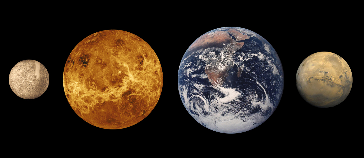
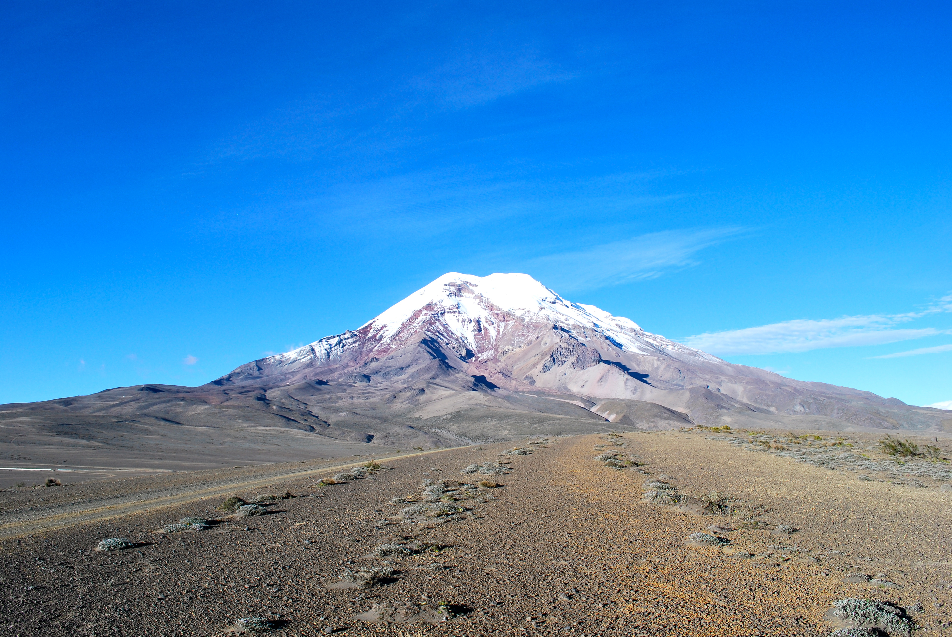


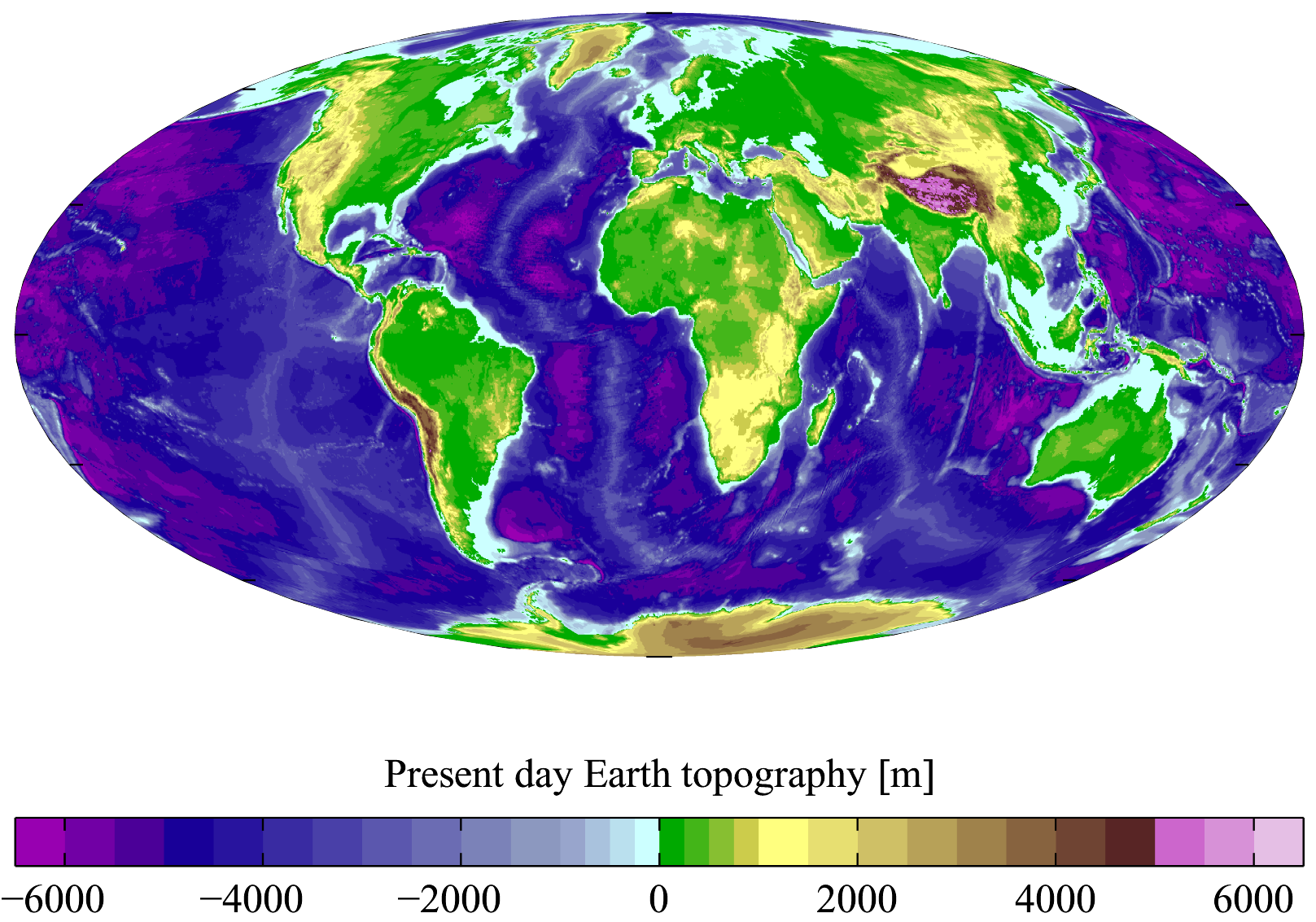

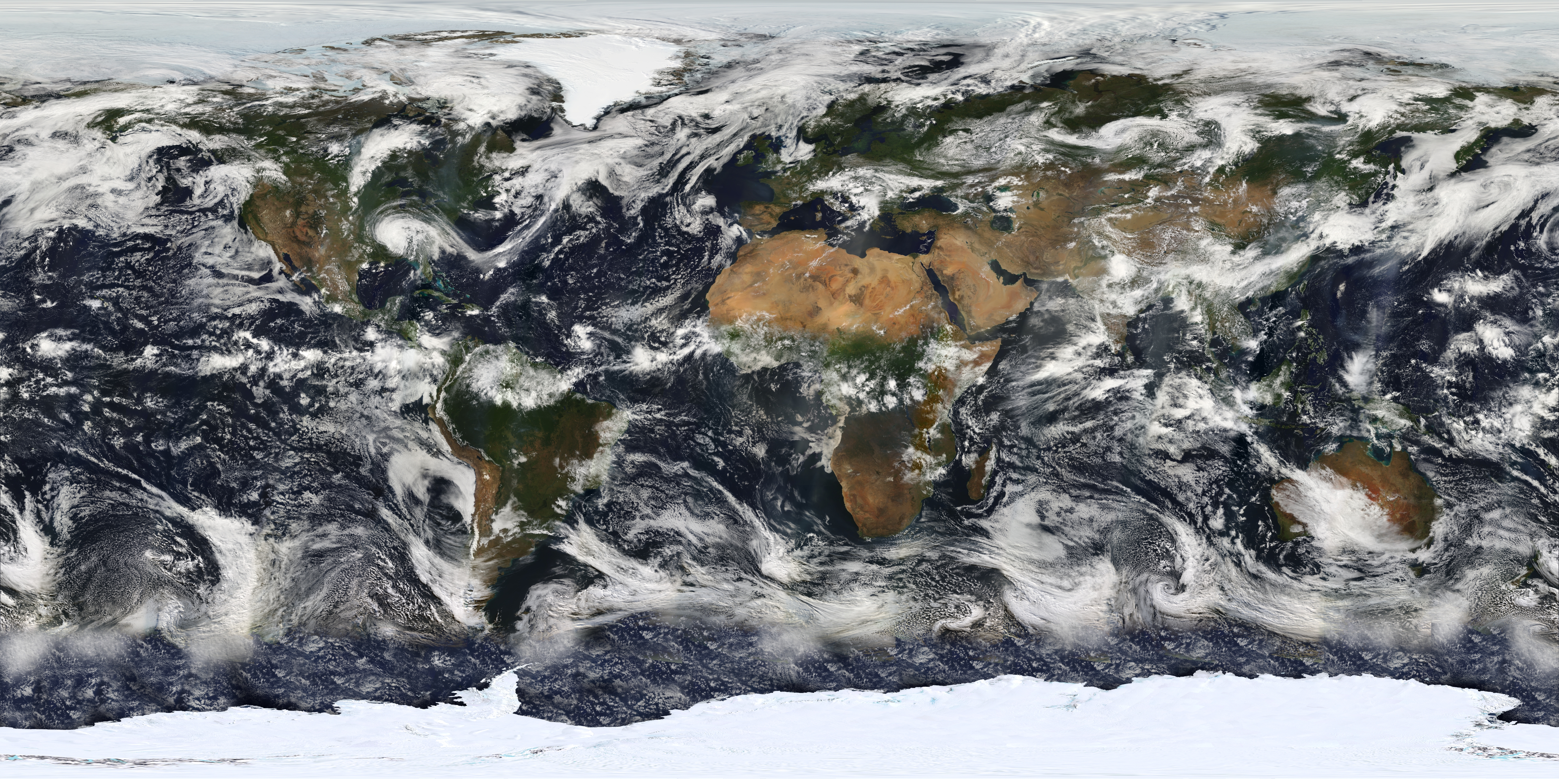
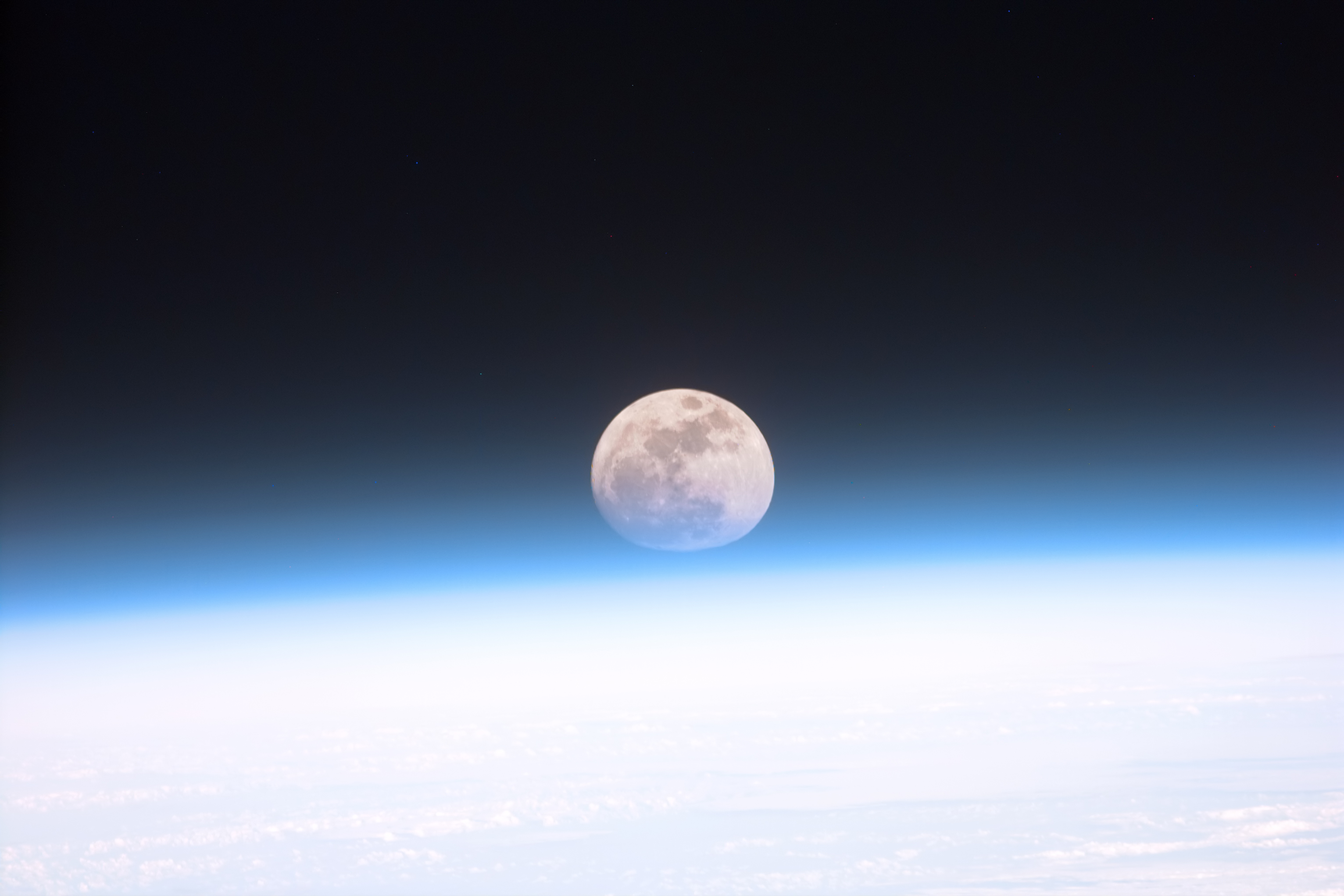

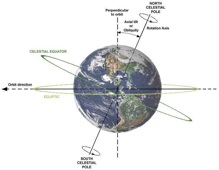
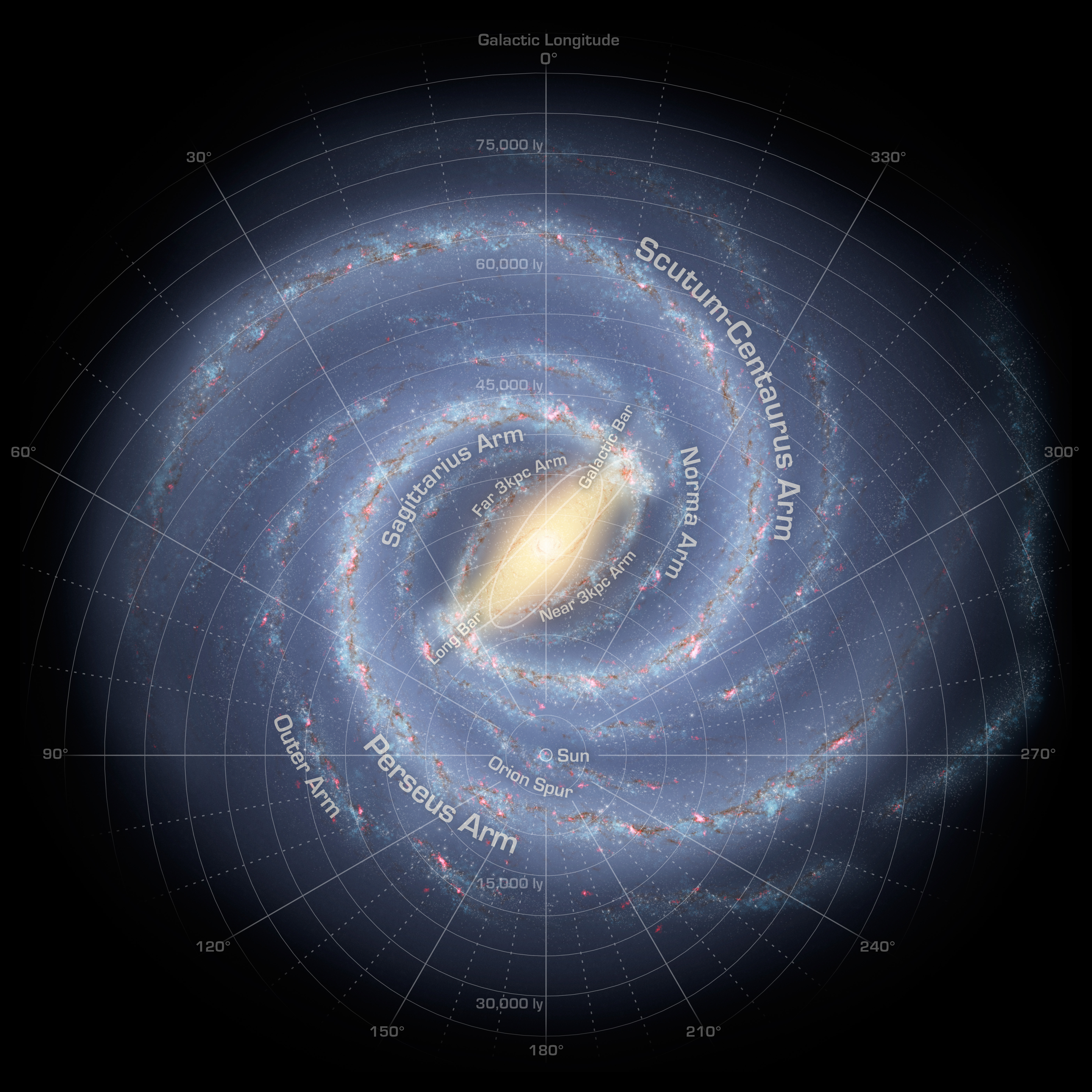
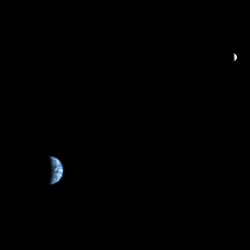
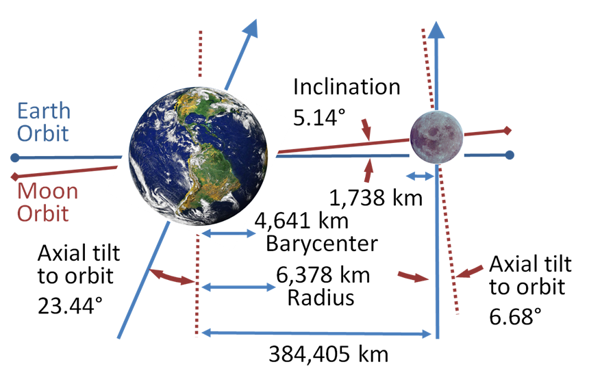
Wikimedia Foundation. 2010.