- Nazca Plate
-
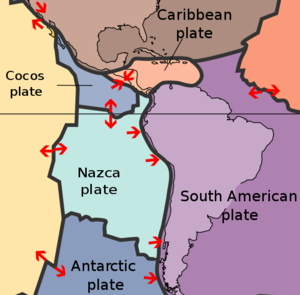
The Nazca Plate, named after the Nazca region of southern Peru, is an oceanic tectonic plate in the eastern Pacific Ocean basin off the west coast of South America. The ongoing subduction along the Peru-Chile Trench of the Nazca Plate under the South American Plate is largely responsible for the Andean orogeny. The Nazca Plate is bound to the west to the Pacific Plate and to the south with the Antarctic Plate through the East Pacific Rise and the Chile Rise respectively. The movement of the Nazca Plate over several hotspots has created some volcanic islands as well as east-west running seamount chains that subduct under South America. Nazca is a relatively young plate both in terms of age of rocks and existence as independent plate.
Contents
Boundaries
East Pacific and Chile Rise
Main articles: East Pacific Rise and Chile RiseA triple junction, the Chile Triple Junction,[1] occurs on the seafloor of the Pacific Ocean off Taitao and Tres Montes Peninsula at the southern coast of Chile. Here three tectonic plates meet: the Nazca Plate, the South American Plate, and the Antarctic Plate.
Peru-Chile Trench
See also: Peru-Chile TrenchThe eastern margin is a convergent boundary subduction zone under the South American Plate and the Andes Mountains, forming the Peru-Chile Trench. The southern side is a divergent boundary with the Antarctic Plate, the Chile Rise, where seafloor spreading permits magma to rise. The western side is a divergent boundary with the Pacific Plate, forming the East Pacific Rise. The northern side is a divergent boundary with the Cocos Plate, the Galapagos Rise.
The subduction of the Nazca plate under southern Chile has a history of producing massive earthquakes including the largest ever recorded on earth, the moment magnitude 9.5 1960 Valdivia earthquake.
Intraplate features
Hotspots
Main articles: Easter hotspot, Juan Fernández hotspot, Galápagos hotspot, and San Felix hotspotA second triple junction occurs at the northwest corner of the plate where the Nazca, Cocos, and Pacific Plates all join off the coast of Colombia. Yet another triple junction occurs at the southwest corner at the intersection of the Nazca, Pacific, and Antarctic Plates off the coast of southern Chile. At each of these triple junctions an anomalous microplate exists, the Galapagos Microplate at the northern junction and the Juan Fernandez Microplate at the southern junction. The Easter Island Microplate is a third microplate that is located just north of the Juan Fernandez Microplate and lies just west of Easter Island.
Aseismic ridges
Main articles: Nazca Ridge, Juan Fernández Ridge, and Carnegie RidgeThe Carnegie Ridge is a 1350-km-long and up to 300-km-wide feature on the ocean floor of the northern Nazca Plate that includes the Galápagos archipelago at its western end. It is being subducted under South America with the rest of the Nazca Plate.
Fracture zones
Darwin Gap is the area between the Nazca Plate and the coast of Chile, where Charles Darwin experienced the earthquake of 1835. It is expected that this area will be the epicenter of a major quake in the near future.[2]
Plate motion
The absolute motion of the Nazca Plate has been calibrated at 3.7 cm/yr east motion (88°), some of the fastest absolute motion of any tectonic plate. The subducting Nazca Plate, which exhibits unusual flat-slab subduction, is tearing as well as deforming as it is subducted (Barzangi and Isacks). The subduction has formed, and continues to form, the volcanic Andes Mountain Range. Deformation of the Nazca Plate even affects the geography of Bolivia, far to the east (Tinker et al.). It was on the Nazca Plate that the 1994 Bolivia earthquake occurred, measuring a magnitude MW of 8.2 and the strongest earthquake occurring deeper than 300 km.
Luckily, very few islands are there to suffer the earthquakes that are a result of complicated movements at these junctions. Juan Fernández Islands is an exception.
Geologic history
See also: Farallon PlateThe precursor of the Nazca Plate and the Cocos Plate to its north was the Farallon Plate, which split in late Oligocene times, about 22.8 Mya, a date arrived at by interpreting magnetic anomalies.
See also
- 1835 Concepción earthquake
- 2010 Chile Earthquake
References
- ^ http://www.nsm.buffalo.edu/courses/gly481-581/McGuire05_2.pdf Tectonics of South America: Chile Triple Junction
- ^ Darwin Gap quake will shake Chile again [1], New Scientist, 30 Jan 2011, accessed 8 Feb 2011.
- Bibliography
- Extreme Science site: "A Lesson in Plate tetonics" The basics explained.
- Galapagos rise junction (map)
- Juan Fernandez and Easter microplate (map)
- Muawia Barazangi and Bryan L. Isacks, "Spatial distribution of earthquakes and subduction of the Nazca plate beneath South America" in Geology Vol. 4, No. 11, pp. 686–692. Abstract
- Mark Andrew Tinker, Terry C. Wallace, Susan L. Beck, Stephen Myers, and Andrew Papanikolas, "Geometry and state of stress of the Nazca plate beneath Bolivia and its implication for the evolution of the Bolivian orocline" in Geology 24(5), pp. 387–390 Abstract
- Cahill, T. and B. Isacks (1992). "Seismicity and shape of the subducted Nazca plate." Journal Geophysical Research 97 (12)
- James, D. (1978). "Subduction of the Nazca plate beneath Central Peru." Geology 6 (3) pp 174 – 178
- Martin Meschede and Udo Barckhausen, "Plate tectonic evolution of the Cocos-Nazca spreading center" (pdf file)
Tectonic plates Major 
Minor Other Aegean Sea · Altiplano · Amurian · Anatolian · Apulian · Australian · Balmoral Reef · Banda Sea · Bird's Head · Burma · Capricorn · Caroline · Conway Reef · Easter · Explorer · Falklands · Futuna · Galapagos · Gonâve · Gorda · Greenland · Halmahera · Iberian · Indian · Iranian · Juan Fernández · Kerguelen · Kermadec · Kula · Madagascar · Manus · Maoke · Mariana · Molucca Sea · New Hebrides · Niuafo'ou · North Andes · North Bismarck · North Galapagos · Nubian · Okhotsk · Okinawa · Panama · Pelso · Philippine Mobile Belt · Rivera · Sangihe · Seychelles · Shetland · Solomon Sea · Somali · South Bismarck · South Sandwich · Sri Lanka · Sunda · Timor · Tisza · Tonga · Woodlark · YangtzeAll Coordinates: 14°49′44″S 74°56′37″W / 14.82889°S 74.94361°W
Categories:- Tectonic plates
- Geology of Chile
- Natural history of South America
- Geology of the Pacific Ocean


Wikimedia Foundation. 2010.