- Amurian Plate
-

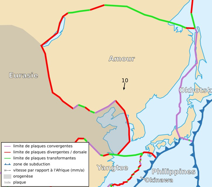
The Amurian Plate (or Amur Plate; also occasionally referred to as the China Plate) is a proposed continental tectonic plate covering Manchuria, the Korean Peninsula, Western Japan, and Primorsky Krai. It is not clear yet whether it is an independent plate or a part of the Eurasian Plate.
It is bounded on the north, west, and southwest by the Eurasian Plate, on the east by the Okhotsk Plate, to the southeast by the Philippine Sea Plate along the Suruga Trough and the Nankai Trough, and the Okinawa Plate, and the Yangtze Plate.
The Baikal Rift Zone is considered a boundary between the Amurian Plate and the Eurasian Plate. GPS measurements indicate that the plate is slowly rotating counter-clockwise.
The Amurian Plate may have been involved in the 1976 Tangshan earthquake in China.
References
- Dongping Wei and Tetsuzo Seno. 1998. Determination of the Amurian Plate Motion. Mantle Dynamics and Plate Interactions in East Asia, Geodynamics Series. v.27, edited by M. F. J. Flower et al., 419p, AGU, Washington D.C. (abstract)
Tectonic plates of East Asia (Eurasian Plate-Pacific Plate Convergence Zone) Large Small Faults and rift zones Baikal Rift Zone · Fukozu Fault · Idosawa Fault · Itoigawa-Shizuoka Tectonic Line · Izu-Bonin-Mariana Arc · Izu Convergence Zone · Japan Median Tectonic Line · Longmenshan Fault · Neodani Fault · Nojima Fault · Northeastern Japan Arc · Philippine Fault System · Senya Fault · Tanna Fault · Ulakhan FaultTrenches and troughs Kuril Trench · Mariana Trench · Japan · Izu-Ogasawara Trench · Japan Trench · Nankai Trough · Sagami Trough · Suruga Trough · Okinawa Trough · Ryukyu Trench · Philippines: · North Luzon Trough · West Luzon Trough · Manila Trench · Philippine Trench · Cotabato Trench · East Luzon Trench · Sulu Trench · Negros Trench · Palawan Trench ·Other Boso Triple JunctionTectonic plates Major 
Minor Other Aegean Sea · Altiplano · Amurian · Anatolian · Apulian · Australian · Balmoral Reef · Banda Sea · Bird's Head · Burma · Capricorn · Caroline · Conway Reef · Easter · Explorer · Falklands · Futuna · Galapagos · Gonâve · Gorda · Greenland · Halmahera · Iberian · Indian · Iranian · Juan Fernández · Kerguelen · Kermadec · Kula · Madagascar · Manus · Maoke · Mariana · Molucca Sea · New Hebrides · Niuafo'ou · North Andes · North Bismarck · North Galapagos · Nubian · Okhotsk · Okinawa · Panama · Pelso · Philippine Mobile Belt · Rivera · Sangihe · Seychelles · Shetland · Solomon Sea · Somali · South Bismarck · South Sandwich · Sri Lanka · Sunda · Timor · Tisza · Tonga · Woodlark · YangtzeAll 
This tectonics article is a stub. You can help Wikipedia by expanding it.