- Huascarán
-
Huascarán 
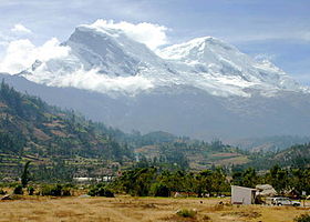
View of Nevado Huascarán Sur from Cordillera NegraElevation 6,768 m (22,205 ft) [1] Prominence 2,776 m (9,108 ft) [2] Listing Country high point
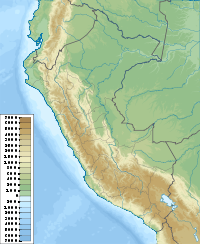
UltraLocation Yungay, Peru Range Cordillera Blanca Coordinates 9°07′17″S 77°36′32″W / 9.12139°S 77.60889°WCoordinates: 9°07′17″S 77°36′32″W / 9.12139°S 77.60889°W Geology Type granite Age of rock Tertiary Climbing First ascent July 20, 1932 Easiest route glacier/snow/ice climb Huascarán or Nevado Huascarán is a mountain in the Peruvian province of Yungay, situated in the Cordillera Blanca range of the Western Andes. The highest southern summit of Huascarán (Huascarán Sur) is the highest point in Peru, and all the Earth's Tropics. Huascarán is the sixth highest mountain in the Western Hemisphere after Aconcagua, Ojos del Salado, Monte Pissis, Cerro Bonete, and Tres Cruces. The mountain was named after Huáscar, a 16th century Inca chieftain who was the Sapa Inca of the Inca empire.[3]
It has an elevation of 6,768 metres (22,205 ft). The core of Nevada Huascarán, like much of the Cordillera Blanca, are Tertiary granites.[4]
Huascarán gives its name to Huascarán National Park which surrounds it, and is a popular location for trekking and mountaineering. Huascarán is normally climbed from the village of Musho to the west via a high camp in the col that separates the summits, known as La Garganta. The ascent normally takes 5–7 days, the main difficulties being the large crevasses that often block the route.[5]
The Huascarán summit is one of the points on the Earth's surface farthest from the Earth's center,[6] closely behind the farthest point, Chimborazo in Ecuador.
Climbing history
The summit was first reached in July 1932 by a joint German–Austrian expedition.[7] The north peak (Huascarán Norte) had previously been climbed in 1908 by a U.S. expedition that included Annie Smith Peck.[8]
In 1989 a group of eight amateur mountaineers, the "Social Climbers" held what was recognised by the Guinness Book of Records (1990 edition) to be "the world highest dinner party" was held on top of the mountain, as documented by Chris Darwin and John Amy in their book The Social Climbers, and raising £10,000 for charity.[9][10]
1970 earthquake
On 31 May 1970, the Ancash earthquake caused a substantial part of the north side of the mountain to collapse. The avalanche mass, an estimated 80 million cubic feet of ice, mud and rock was about half a mile wide and a mile long. It advanced about 11 miles (18 km) at an average speed of 280 to 335 km per hour.[11] burying the towns of Yungay and Ranrahirca under ice and rock, killing more than 20,000 people.[12] At least 20,000 people were also killed in Huaraz, site of a 1941 avalanche which killed over 6000 (see Palcacocha Lake).[13] Estimates suggest that the earthquake killed over 66,000 people.[14][15]
Also buried by an avalanche was a Czechoslovak mountaineering team, none of whose members was ever seen again.[16] This and other earthquake-induced avalanche events are often described incorrectly as "eruptions" of Huascarán, which is not of volcanic origin.
An earlier landslide on January 11, 1962, caused by a rapid rise in temperature,[13] killed an estimated 4,000 people.[17]
Bibliography
- Biggar, John (2005). The Andes - A Guide for Climbers (3rd ed.). Castle Douglas. ISBN 0-9536087-2-7.
- Room, Adrian (1997). Placenames of the World. McFarland and Company. ISBN 0-7864-0172-9.
References
- ^ Some authorities give 6,746 metres.
- ^ "ultra-prominences". peaklist.org. http://www.peaklist.org/WWlists/ultras/peru.html. Retrieved 2008-12-29.
- ^ Room, Adrian
- ^ Ricker, John F., Yuraq Janka: Cordilleras Blanca and Rosko, Alpine Club of Canada, 1977, ISBN 0-920330-04-5, after Wilson, Reyes, and Garayar, 1967.
- ^ Biggar, John
- ^ "Tall Tales about Highest Peaks". Australian Broadcasting Corporation. http://www.abc.net.au/science/k2/moments/s1086384.htm. Retrieved 2008-12-29.
- ^ "1932 ascent". huascaranperu.net. http://www.huascaranperu.net/Ascenciones.htm. Retrieved 2008-12-29.
- ^ "Annie Smith Peck". Dr. Russell A. Potter. http://www.ric.edu/faculty/rpotter/smithpeck.html. Retrieved 2010-12-05.
- ^ Monge-Nájera, Julián (1995). ABC de la evolución. EUNED. p. 58. ISBN 9977648220.
- ^ "Mouth-watering challenge". Epping Forest Guardian. 21 September 2007. http://www.guardian-series.co.uk/news/1705342.mouthwatering_challenge/. Retrieved 2011-05-31.
- ^ http://www.iris.edu/seismo/quakes/1970peru/Plafker1971.pdf
- ^ U.S. Dept. of the Interior (October 1970). "The Peru Earthquake: a Special Study". Bulletin of the Atomic Scientists 26 (8): 17–19.
- ^ a b Sacred mountains: Myth and Morphology
- ^ ALEXANDER E. GATES; DAVID RITCHIE (2006). ENCYCLOPEDIA OF EARTHQUAKES AND VOLCANOES. Infobase Publishing. p. 110.
- ^ Rob Rachowiecki; Charlotte Beech (2004). Peru. Lonely Planet. p. 308.
- ^ "Yungay history". Jay A. Frogel. http://www.jayfrogel.com/Peru98/Peru98_Yungay/0Peru98_Yungay_home.html. Retrieved 2010-12-05.
- ^ "1962: Thousands killed in Peru landslide". British Broadcasting Corporation. 1962-01-11. http://news.bbc.co.uk/onthisday/hi/dates/stories/january/11/newsid_3306000/3306665.stm. Retrieved 2010-12-05.
External links
Categories:- Mountains of Peru
- Ancash Region
Wikimedia Foundation. 2010.

