- Degree Confluence Project
-
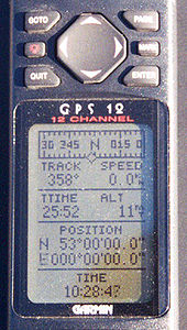 A GPS unit at confluence 53N 0, in Lincolnshire, England
The Degree Confluence Project is a World Wide Web-based all-volunteer project which aims to have people visit each of the integer degree intersections of latitude and longitude on Earth, posting photographs and a narrative of each visit online. Intersections are defined on the horizontal datum WGS 84. The project describes itself as "an organized sampling of the world".
Contents
Description
Visitors to degree confluences almost always make use of GPS receivers, but visits can be achieved using only a map on the appropriate datum, or a map on another datum but with the appropriate correction applied. For a successful visit, the visitor must get within 100 metres of the confluence point, and post a narrative and several photographs to the project website. A visit, or attempted visit, which does not conform to these rules may still be recorded on the website as an incomplete visit. The project encourages visits to degree confluences which have been visited previously, and many confluence points in North America and Europe have been visited several times.
The total number of degree confluences is 64,442,[1] of which 21,543 are on land, 38,409 on water, and 4,490 on the Antarctic and Arctic ice caps.[2] The project categorizes degree confluences as either primary or secondary. A confluence is primary only if it is on land or within sight of land. In addition, at higher latitudes only some points are designated primary, because confluences crowd together near the poles.[3] Both primary and secondary confluences may be visited and recorded.
As of October 30, 2009, the project reported that the world has 16,324 indexed primary degree confluence points and 5,749 of them, in 181 countries, have been visited at least once. This means that 35.19% of the world's primary confluences have been completed. In addition, 540 unique visits have been made to secondary degree confluences. There have been a total of 10,900 degree confluence visits made by 11,368 visitors.[4] 84,105 degree confluence photographs have been posted.[5] The project is currently hosted by ibiblio.
History
The project was started by Alex Jarrett in February 1996 because he "liked the idea of visiting a location represented by a round number such as 43°00'00"N 72°00'00"W. What would be there? Would other people have recognized this as a unique spot?"[6] .
Milestones
 The only integer degree intersection of latitude and longitude in Luxembourg: N 50° E 6°, June 2009
- First degree confluence visit posted to the website[7]: 43°N 72°W / 43°N 72°W in New Hampshire, USA by Alex Jarrett (project founder) and Peter Cline on February 20, 1996.
- Highest Confluence: 33°N 80°E / 33°N 80°E in Kuba, Tibet, China at 19,143 feet (5,835 m), first visited by Greg Michaels and Robert Whitfield on May 29, 2005.
- Lowest Confluence: 30°N 27°E / 30°N 27°E in Matrūh, Egypt at -255 feet (-78 m), first visited by Dave Morrison, Steve Price and Tony Carlisle on December 4, 2004.
Notes
- ^ Latitude lines 89°N to 89°S (179), multiplied by 360° of longitude (360), plus the two poles (2) = 179 × 360 + 2 = 64,442.
- ^ Classifications as of August 4, 2007
- ^ Poles Problem
- ^ Mautz, R. (2008): Sampling the World, Coordinates – Positioning, Navigation and Beyond, no. 3, pp. 22–27, 2008.
- ^ statistics page
- ^ project history
- ^ some degree confluence visits that pre-date this visit have since been posted on the project's website
See also
- Geocaching
- Geograph British Isles project
External links
Circles of latitude / Meridians  145°145°65°75°Categories:
- Photography websites
- GPS
- Outdoor locating games
- Internet properties established in 1996

Wikimedia Foundation. 2010.