- Confluence Project
-
- See Degree Confluence Project for the quest to find the intersections of whole number latitude and longitude.
The Confluence Project is a series of outdoor installations and interpretive artworks located in public parks along the Columbia River and its tributaries in the U.S. states of Washington and Oregon. Works underway may include both building and landscape designs as well as integrated artwork. The project draws on the region's history, including Native American myths and entries from the Lewis and Clark Expedition journals, to "evoke a landscape and a way of life submerged in time and memory."[1]
Artist and architect Maya Lin, the central figure in the Confluence Project, is designing installations that follow the path of Lewis and Clark through the Columbia River Basin. Lin is collaborating with landscape architects to restore natural environments, and each artwork will draw text from Lewis and Clark's journals or traditions grounded in Native American cultures.
Sites
Washington
- Cape Disappointment State Park, Ilwaco, Washington[2] (Completed 2006)
- Ridgefield National Wildlife Refuge, Vancouver, Washington (In planning stages)
- Vancouver Land Bridge at Fort Vancouver National Historic Site, Vancouver, Washington[3] (Completed 2008)
- Sacajawea State Park, Pasco, Washington[4] (Completed 2010)
- Chief Timothy Park, Clarkston, Washington[5] (Scheduled for completion in Spring 2011)
Oregon
- Sandy River Delta [6](Completed 2008)
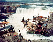
- Celilo Falls (Scheduled for completion in Fall 2012)
References
- ^ Raymond, Camela (November 2007). "The Shape of Memory". Portland Monthly.
- ^ Cape Disappointment State Park
- ^ Fort Vancouver National Historic Site (U.S. National Park Service)
- ^ Sacajawea State Park
- ^ Confluence Project: project sites
- ^ Confluence Project: project sites: Sandy River Delta
External links
- "A Meeting Of Minds". The Seattle Times. 2005-06-12. http://seattletimes.nwsource.com/html/pacificnw06122005/coverstory.html. Retrieved 2006-09-07.
- "Maya Lin advances Confluence Project". The Oregonian. 2004-04-01. http://www.oregonlive.com/special/lewisandclark/index.ssf?/special/oregonian/lewisandclark/040104.html. Retrieved 2006-09-07.
Columbia River Provinces and
states traversed
Lists - Cities
- Crossings
- Dams
- Rapids
- Tributaries
Geology and Geography - Geology of the Pacific Northwest
- Columbia River Basalt Group
- Columbia River Gorge
- Missoula Floods
- Bonneville Slide/Bridge of the Gods land bridge
- 1700 Cascadia earthquake
- 1980 eruption of Mount St. Helens
- Columbia Mountains
History - Celilo Falls
- Kettle Falls
- Dalles des Morts
- Robert Gray exploration
- Lewis and Clark Expedition
- David Thompson
- Astor Expedition
- Fort Vancouver
- Steamboats of the Columbia River
- Big Bend Gold Rush
- Steamboats of the Arrow Lakes
- Steamboats of the upper Columbia and Kootenay Rivers
- Columbia River Treaty
- Historic Columbia River Highway
- Columbia Basin Project
- Bonneville Power Administration
- Hanford Site
- Sohappy v. Smith
- Boldt Decision
- Vanport flood of 1948
Ecology and culture - Pacific salmon
- Woody Guthrie
- Confluence Project
Categories:- Outdoor sculptures in Washington (state)
- Outdoor sculptures in Oregon
- Columbia River Gorge
- United States art museum and gallery stubs
Wikimedia Foundation. 2010.
