- Missoula Floods
-
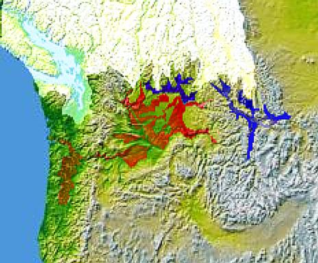
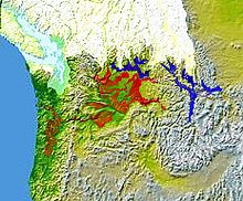 Glacial Lake Columbia (west) and Glacial Lake Missoula (east) are shown south of Cordilleran Ice Sheet. The areas inundated in the Columbia and Missoula floods are shown in red.
The Missoula Floods (also known as the Spokane Floods or the Bretz Floods) refer to the cataclysmic floods that swept periodically across eastern Washington and down the Columbia River Gorge at the end of the last ice age. The glacial flood events have been researched since the 1920s. These glacial lake outburst floods were the result of periodic sudden ruptures of the ice dam on the Clark Fork River that created Glacial Lake Missoula. After each ice dam rupture, the waters of the lake would rush down the Clark Fork and the Columbia River, inundating much of eastern Washington and the Willamette Valley in western Oregon. After the rupture, the ice would reform, recreating Glacial Lake Missoula once again. Geologists estimate that the cycle of flooding and reformation of the lake lasted an average of 55 years and that the floods occurred several times over the 2,000 year period between 15,000 and 13,000 years ago. U.S. Geological Survey hydrologist Jim O'Connor and Spanish Center of Environmental Studies scientist Gerard Benito have found evidence of at least twenty-five massive floods, the largest discharging ~10 cubic kilometers per hour.[2] Alternate estimates for the peak flow rate of the largest flood include 17 cubic kilometers per hour[3] and range up to 60 cubic kilometers per hour.[4] The maximum flow speed approached 36 meters/second (130 km/h or 80 mph).[3]
Contents
Flood hypothesis proposed
Geologist J Harlen Bretz first recognized evidence of the catastrophic floods, which he called the Spokane Floods, in the 1920s. He was researching the Channeled scablands in Eastern Washington, the Columbia Gorge and the Willamette Valley of Oregon. In the summer of 1922, and for the next seven years, Bretz conducted field research of the Columbia River Plateau. He had been interested in unusual erosion features in the area since 1910 after seeing a newly published topographic map of the Potholes Cataract. Bretz coined the term Channeled Scablands in 1923 to describe the area near the Grand Coulee, where massive erosion had cut through basalt deposits. Bretz published a paper in 1923, arguing that the channeled scablands in Eastern Washington were caused by massive flooding in the distant past.
Bretz's view, which was seen as arguing for a catastrophic explanation of the geology, ran against the prevailing view of uniformitarianism, and Bretz's views were initially held in disregard. The Geological Society of Washington, D.C invited the young Bretz to present his previously published research at a January 12, 1927 meeting where several other geologists presented competing theories. Another geologist at the meeting, J.T. Pardee, had worked with Bretz and had evidence of an ancient glacial lake that lent credence to Bretz's theories. Bretz defended his theories and this kicked off an acrimonious forty year debate over the origin of the Scablands. Both Pardee and Bretz continued their research over the next 30 years, collecting and analyzing evidence that led him to identify Lake Missoula as the source of the Spokane Flood and creator of the Channeled Scablands.[5][6]
After J.T. Pardee studied the canyon of the Flathead River, he estimated that flood waters in excess of 45 miles per hour (72 km/h) would be required to roll the largest of the boulders moved by the flood. He estimated the water flow was nine cubic miles per hour, more than the combined flow of every river in the world.[7] Estimates place the flow at ten times the flow of all current rivers combined.[3]
The Missoula Floods have also been referred to as the Bretz Floods in honor of Bretz.
Flood initiation
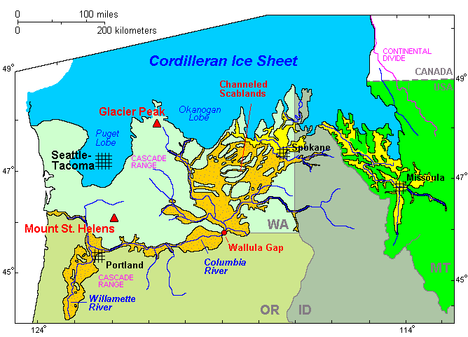
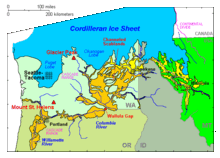 Cordilleran Ice Sheetmaximum extent of Glacial Lake Missoula (eastern) and Glacial Lake Columbia (western)areas swept by Missoula and Columbia floods
As the depth of the water in Lake Missoula increased, the pressure at the bottom increased enough to lower the freezing point of water below the temperature of the ice forming the dam. This allowed liquid water to seep into minuscule cracks present in the ice dam. Over a period of time, the friction from water flowing through these cracks generated enough heat to melt the ice walls and enlarge the cracks. This allowed more water to flow through the cracks, generating more heat, allowing even more water to flow through the cracks. This feedback cycle eventually weakened the ice dam so much that it could no longer support the pressure of the water behind it, and it failed catastrophically.[8] This same process triggered a similar event, a jökulhlaup, in Iceland on November 5, 1996.[9]
Flood events
As the water emerged from the Columbia River gorge, it backed up again at the 1 mile (1.6 km) wide narrows near Kalama, Washington. Some temporary lakes rose to an elevation of more than 400 ft (120 m), flooding the Willamette Valley to Eugene, Oregon and beyond. Iceberg rafted glacial erratics and erosion features are evidence of these events. Lake-bottom sediments deposited by the Missoula Floods are the primary reason for the agricultural richness of the Willamette Valley.
After analysis and controversy, geologists now believe that there were 40 or more separate floods, although the exact source of the water is still being debated. The peak flow of the floods is estimated to be 40 to 60 cubic kilometers per hour (9.5 to 15 cubic miles per hour).[3][4] The maximum flow speed approached 36 meters/second (130 km/h or 80 mph).[3] Up to 1.9×10¹⁹ joules of potential energy were released by each flood (the equivalent of 4500 megatons of TNT).[10] The cumulative effect of the floods was to excavate 210 cubic kilometres (50 cu mi) of loess, sediment and basalt from the channeled scablands of eastern Washington and to transport it downstream.[4]
Multiple flood hypothesis
The multiple flood hypothesis was first proposed by R.B. Waitt, Jr., in 1980. Waitt argued for a sequence of multiple floods — 40 or more.[11][12][13] Waitt's proposal was based mainly on analysis from glacial lake bottom deposits in Ninemile Creek and the flood deposits in Burlingame Canyon. His most compelling argument for separate floods was that the Touchet bed deposits from two successive floods were found to be separated by two layers of volcanic ash (tephra) with the ash separated by a fine layer of windblown dust deposits, located in a thin layer located between sediment layers ten rhythmites below the top of the Touchet beds (see picture). The two layers of volcanic ash are separated by 1–10 cm of airborne nonvolcanic silt. The tephra is Mount St. Helens ash that fell in eastern Washington. By analogy, since there were 40 layers with comparable characteristics at Burlingame Canyon, Waitt argued they all could be considered to have similar separation in deposition time.[13]
Controversy over number and source of floods
The controversy whether the Channeled Scabland landforms were formed mainly by multiple periodic floods or by a single grand-scale cataclysmic flood from late Pleistocene Glacial Lake Missoula or from an unidentified Canadian source continued through 1999.[14] Shaw’s team of geologists reviewed the sedimentary sequences of the Touchet beds and concluded that the sequences do not automatically imply multiple floods separated by decades or centuries. Rather, they proposed that sedimentation in the Glacial Lake Missoula basin was the result of jökulhlaups draining into Lake Missoula from British Columbia to the north. Further, Shaw’s team proposed the scabland flooding might have partially originated from an enormous subglacial reservoir that extended over much of central British Columbia, particularly including the Rocky Mountain Trench, which may have discharged by several paths including one path through Lake Missoula. This discharge, if occurring concurrently with the breach of the Lake Missoula ice dam, would have provided significantly larger volumes of water. Further, Shaw and team proposed that the rhythmic Touchet beds are the result of multiple pulses, or surges, within a single larger flood.[14]
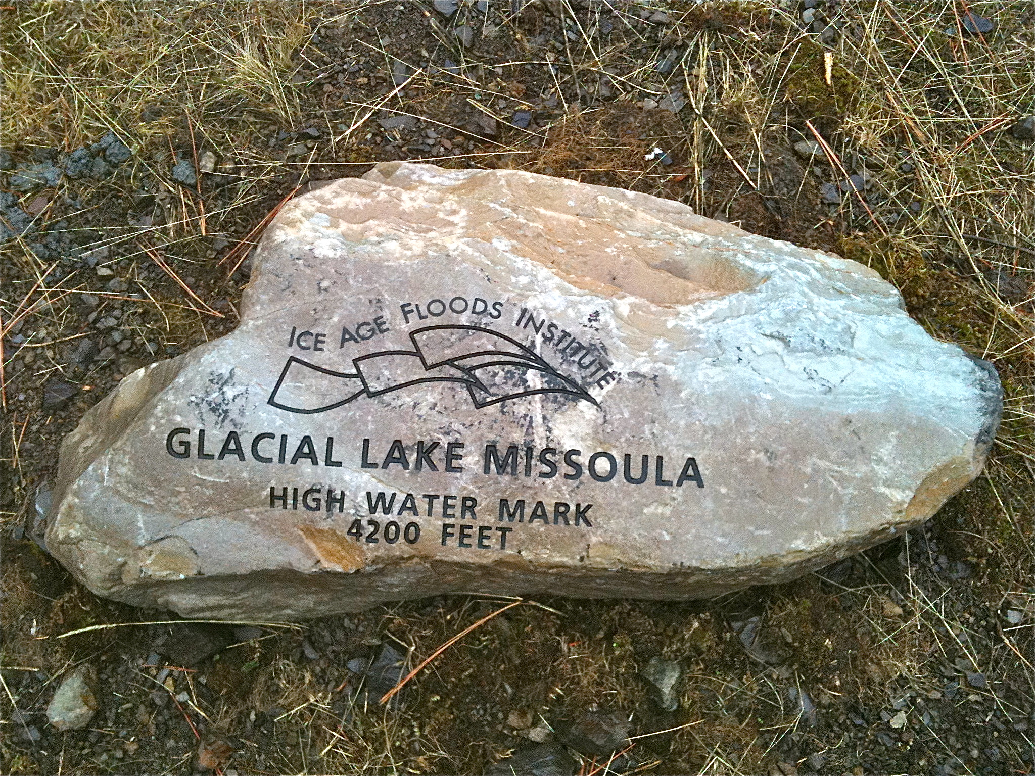
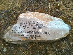 Glacial Lake Missoula high water mark, 4200 ft., near Missoula, MT
In 2000, a team led by Komatsu simulated the floods numerically with a 3-dimensional hydraulic model. They based the Glacial Lake Missoula discharge rate on the rate predicted for the Spokane Valley–Rathdrum Prairie immediately downstream of Glacial Lake Missoula, for which a number of previous estimates had placed the maximum discharge of 17 × 106m3/s and total amount of water discharged equal to the maximum estimated volume of Lake Missoula (2184 km3). Neglecting erosion effects, their simulated water flow was based on modern-day topography. Their major findings were that the calculated depth of water in each flooded location except for the Spokane Valley–Rathdrum Prairie was shallower than the field evidence showed. For example, their calculated water depth at the Pasco Basin–Wallula Gap transition zone is about 190 m, significantly less than the 280–300 m flood depth indicated by high-water marks. They concluded that a flood of ~106m3/s could not have made the observed high-water marks.[15]
In comment on the Komatsu analysis, Atwater’s team observed that there is substantial evidence for multiple large floods, including evidence of mud cracks and animal burrows in lower layers which were filled by sediment from later floods. Further, evidence for multiple flood flows up side arms of Glacial Lake Columbia spread over many centuries have been found. They also pointed out that the discharge point from Lake Columbia varied with time, originally flowing across the Waterville Plateau into Moses Coulee but later, when the Okanagon lobe blocked that route, eroding the Grand Coulee to discharge there as a substantially lower outlet. The Komatsu analysis does not evaluate the impact of the considerable erosion observed in this basin during the flood (or floods) – hence the assumption that the flood hydraulics can be modeled using modern-day topography is an area which warrants further consideration – earlier narrower constrictions at places such as Wallula Gap and through the Columbia Gorge could be expected to produce higher flow resistance and correspondingly higher floods.[16]
The current understanding
The dating for Waitt’s proposed separation of layers into sequential floods has been supported by subsequent paleomagnetism studies, which supports a 30-40 year interval between depositions of Mount St. Helens’ ash, and hence flood events, but do not preclude an up to 60 year interval.[8] Offshore deposits on the bed of the Pacific at the mouth of the Columbia River include 120 meters of material deposited over a several thousand year period that corresponds to the period of multiple scabland floods seen in the Touchet Beds. Based on Waitt's identification of 40 floods, this would give an average separation between floods of 50 years.[17]
Although these sources provide support for temporal separation of floods, they do not definitively identify the source of water for the floods, which remains an open question.
See also
- Outburst flood
- Glacial Lake Missoula
- Glacial lake outburst flood
- Ice Age Floods National Geologic Trail
- J Harlen Bretz, the geologist who first recognized the Missoula floods
- Rhythmites, laminated deposits or varves used to estimate the flooding cycle
- Jökulhlaup, an Icelandic term used to describe a subglacial outburst flood
- Giant current ripples
References
- ^ http://www.nps.gov/iceagefloods/d.htm NPS Ice Age Floods Study of Alternatives Background
- ^ "Science writer Richard Hill gives a brief geologic history of the Columbia River Gorge". http://www.oregonlive.com/O/relationships/index.ssf?/base/living/1212706534232180.xml&coll=7. Retrieved 2008-06-15.
- ^ a b c d e Bjornstad, Bruce N. (c2006). On the trail of the Ice Age floods : a geological field guide to the mid-Columbia basin / Bruce Bjornstad.. Sandpoint, Idaho: Keokee Books. pp. 2. ISBN 9781879628274.
- ^ a b c Allen, John Eliot; Burns, Marjorie and Sargent, Sam C. (c1986). Cataclysms on the Columbia : a layman's guide to the features produced by the catastrophic Bretz floods in the Pacific Northwest. Portland, OR: Timber Press. pp. 104. ISBN 0881920673.
- ^ J Harlen Bretz, (1923), The Channeled Scabland of the Columbia Plateau. Journal of Geology, v.31, p.617-649.
- ^ J Harlen Bretz, (1925), The Spokane flood beyond the Channeled Scablands. Journal of Geology, v.33, p.97-115, 236-259.
- ^ Alt, David; Hundman, Donald W. (1995). Northwest Exposures: A Geologic History of the Northwest. Mountain Press. pp. 381–390. ISBN 0-87842-323-0.
- ^ a b Clague, John J.; Barendregt, Rene, Enkin, Randolph J. and Franklin F. Foit, Jr. (March 2003). "Paleomagnetic and tephra evidence for tens of Missoula floods in southern Washington". Geology (The Geological Society of America) 31: 247–250. Bibcode 2003Geo....31..247C. doi:10.1130/0091-7613(2003)031<0247:PATEFT>2.0.CO;2.
- ^ Roberts, Matthew J.; Fiona S. Tweed, Andrew J. Russell, Óskar Knudsen, Daniel E. Lawson, Grahame J. Larson, Edward B. Evenson, and Helgi Björnsson (May 2002). "Glaciohydraulic supercooling in Iceland". Geology (The Geological Society of America) 30: 439–442. Bibcode 2002Geo....30..439R. doi:10.1130/0091-7613(2002)030<0439:GSII>2.0.CO;2.
- ^ Allen, John Eliot; Burns, Marjorie and Sargent, Sam C. (c1986). Cataclysms on the Columbia : a layman's guide to the features produced by the catastrophic Bretz floods in the Pacific Northwest. Portland, OR: Timber Press. pp. 199–200. ISBN 0881920673.
- ^ Waitt, R.B., Jr, 1980, About 40 last-glacial Lake Missoula jökulhlaups through southern Washington: Journal of Geology, v. v. 88pp. 653-679.Web of Science
- ^ Waitt, R.B., Jr, 1984, Periodic jökulhlaups from Pleistocene Glacial Lake Missoula—New evidence from varved sediment in northern Idaho and Washington: Quaternary Research, v. v. 22pp. 46-58.
- ^ a b Waitt, R.B., Jr, 1985, Case for periodic, colossal jökulhlaups from Pleistocene glacial Lake Missoula: Geological Society of America Bulletin, v. v. 96pp. 1271-1286.
- ^ a b Shaw, J., Munro-Stasiuk, M., Sawyer, B., Beaney, C., Lesemann, J.-E., Musacchio, A., Rains, B., and Young, R.R., 1999, The Channeled Scabland: Back to Bretz?: Geology, v. v. 27pp. 605-608
- ^ G. Komatsu, H. Miyamoto, K. Ito H. Tosaka and T. Tokunaga (2000) The Channeled Scabland: Back to Bretz?: Comment and Reply doi: 10.1130/0091-7613(2000)28<573:TCSBTB>2.0.CO;2 Geology June 2000 v. 28 no. 6 p. 573-574
- ^ Brian F. Atwater, Gary A. Smith, and Richard B. Waitt; The Channeled Scabland: Back to Bretz?: Comment and Reply: COMMENT; Geology June 2000, v. 28, p. 574, doi:10.1130/0091-7613(2000)28<576:TCSBTB>2.0.CO;2
- ^ Brunner, Charlotte A.; Normark, William R., Zuffa, Gian G. and Serra, Francesca (1999). "Deep-sea sedimentary record of the late Wisconsin cataclysmic floods from the Columbia River". Geology 27: 463–466. Bibcode 1999Geo....27..463B. doi:10.1130/0091-7613(1999)027<0463:DSSROT>2.3.CO;2.
Further reading
- Allen, John Eliot; Marjorie Burns, Scott Burns (2009). Cataclysms on the Columbia: The Great Missoula Floods (Rev. 2nd ed.). Portland, Or.: Ooligan Press. ISBN 9781932010312.
- Soennichsen, John (2008). Bretz's Flood: The Remarkable Story of a Rebel Geologist and the World's Greatest Flood. Seattle, Wa.: Sasquatch Books. ISBN 9781570615054.
- Norman B. Smyers and Roy M. Breckenridge (2003). "Glacial Lake Missoula, Clark Fork ice dam, and the floods outburst area: Northern Idaho and western Montana". In T. W. Swanson. Western Cordillera and adjacent areas. Geological Society of America Field Guide. 4. "Bretz's ideas for such large-scale flooding were viewed as a challenge to the uniformitarian principles then ruling the science of geology (p. 2)"
External links
- PBS's NOVA (TV series): Mystery of the Megaflood
- Ice Age Floods Institute
- University of Wisconsin overview of the Missoula Floods and their impacts.
- Dietrich, William (2007-09-30). "Trailing an Apocalypse". Seattle Times – Pacific Northwest magazine. http://seattletimes.nwsource.com/html/pacificnw09302007/2003905120_pacificpice30.html.
- The channeled scabland: a guide to the geomorphology of the Columbia Basin, Washington : prepared for the Comparative Planetary Geology Field Conference held in the Columbia Basin, June 5–8, 1978 / sponsored by Planetary Geology Program, Office of Space Science, National Aeronautics and Space Administration ; edited by Victor R. Baker and Dag Nummedal.
- National Park Service: Ice Age Floods
Ice Age Floods National Geologic Trail in the Pacific Northwest Ice Age Glacial Floods Missoula Floods
Glacial Lakes Glacial Lake Missoula • Glacial Lake ColumbiaTemporary Lakes Lake Lewis • Lake Condon • Lake AllisonIce Age Floods Glacial Residue Ice Age Floods Erosion & Deposition Features Related contemporaneous events Bonneville FloodColumbia River Provinces and
states traversed
Lists - Cities
- Crossings
- Dams
- Rapids
- Tributaries
Geology and Geography - Geology of the Pacific Northwest
- Columbia River Basalt Group
- Columbia River Gorge
- Missoula Floods
- Bonneville Slide/Bridge of the Gods land bridge
- 1700 Cascadia earthquake
- 1980 eruption of Mount St. Helens
- Columbia Mountains
History - Celilo Falls
- Kettle Falls
- Dalles des Morts
- Robert Gray exploration
- Lewis and Clark Expedition
- David Thompson
- Astor Expedition
- Fort Vancouver
- Steamboats of the Columbia River
- Big Bend Gold Rush
- Steamboats of the Arrow Lakes
- Steamboats of the upper Columbia and Kootenay Rivers
- Columbia River Treaty
- Historic Columbia River Highway
- Columbia Basin Project
- Bonneville Power Administration
- Hanford Site
- Sohappy v. Smith
- Boldt Decision
- Vanport flood of 1948
Ecology and culture Categories:- Floods in the United States
- Geology of Montana
- Geology of Oregon
- Geology of Washington (state)
- Columbia River Gorge
- Megafloods
Wikimedia Foundation. 2010.