- Kalama, Washington
Infobox Settlement
official_name = Kalama, Washington
settlement_type =City
nickname =
motto =
imagesize =
image_caption =
image_
imagesize =
image_caption =
image_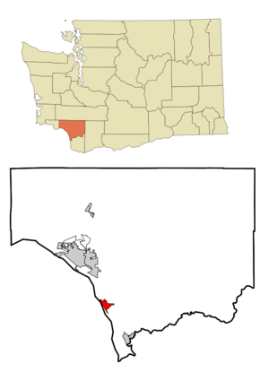
mapsize = 250px
map_caption = Location of Kalama, Washington
mapsize1 =
map_caption1 =subdivision_type = Country
subdivision_name =United States
subdivision_type1 = State
subdivision_name1 =Washington
subdivision_type2 = County
subdivision_name2 = Cowlitzgovernment_footnotes =
government_type =
leader_title =
leader_name =
leader_title1 =
leader_name1 =
established_title =
established_date =unit_pref = Imperial
area_footnotes =
area_magnitude =
area_total_km2 = 6.0
area_land_km2 = 5.9
area_water_km2 = 0.1
area_total_sq_mi = 2.3
area_land_sq_mi = 2.3
area_water_sq_mi = 0.0population_as_of = 2000
population_footnotes =
population_total = 1783
population_density_km2 = 302.4
population_density_sq_mi = 783.3timezone = Pacific (PST)
utc_offset = -8
timezone_DST = PDT
utc_offset_DST = -7
elevation_footnotes =
elevation_m = 12
elevation_ft = 39
latd = 46 |latm = 0 |lats = 31 |latNS = N
longd = 122 |longm = 50 |longs = 33 |longEW = Wpostal_code_type =
ZIP code
postal_code = 98625
area_code = 360
blank_name = FIPS code
blank_info = 53-34645GR|2
blank1_name = GNIS feature ID
blank1_info = 1512340GR|3
website =
footnotes =Kalama is a city in Cowlitz County,
Washington ,United States . It is part of the 'Longview, Washington Metropolitan Statistical Area '. The population was 1,783 at the 2000 census.History
Kalama was officially incorporated on
November 29 ,1871 . It was named after the nearby Kalama River which took its name from a Native Hawaiian named John Kalama. [ [http://www.cityofkalama.com/history.htm City of Kalama, Washington | History ] ] Kalama was the northern terminus of a railroad ferry operated by the Northern Pacific Railroad fromGoble, Oregon . This was a critical link in rail service between 1883 when the service began until 1909 when the major rail bridges in Portland were completed. [http://www.brian894x4.com/LewisandClarkExplorer.html | Active Short lines in the Pacific Northwest] Kalama originated with a stake driven by Gen. John W. Sprague of the Northern Pacific Railroad who in March 1870 selected a spot near the mouth of the Kalama river to mark the beginning point of Northern Pacific's Pacific Division.cite book
last =Armbruster
first = Kurt
authorlink =
coauthors =
title =Orphan Railroad: The railroad comes to Seattle, 1953-1911
publisher =Washington State University Press
date = 1999
location = Pullman, WA
pages =27,29,44,99
url =
doi =
id =
isbn = 0-87422-186-2] From that stake, the Northern Pacific began building north to Puget Sound, ultimately getting to Commencement Bay at what was to become Tacoma before going bankrupt. Construction began in April 1871 with a crew of 800 men, with the official 'first spike' being driven in May 1871 Scheduled service from Tacoma to Kalama began on January 5, 1874. The Portland-Hunters line was completed about the same time that the cermonial spike was driven west ofHelena, Montana to mark the completion of the transcontinental Northern Pacific Railroad in the fall of 1883. The following year in October 1884, a 3 track, convert|360|ft|m|sing=on long railroad ferry marked the beginning of 25 years of ferry service across the Columbia River .Hunterscite book
last = McArthur
first = Lewis A.
authorlink = Lewis A. McArthur
coauthors =Lewis L. McArthur
title =Oregon Geographic Names
origyear = 1928
edition = Sixth Edition
year = 1992
publisher =Oregon Historical Society Press
location = Portland,Oregon
id = ISBN 0-87595-277-1
pages = 431 ] was located near the south end of Sandy Island about a mile south of Goble. However the crossing times were excessive when the Tacoma had to work against the tide, and the ferry slip was soon moved to Goble at the north end of Sandy Island and directly across from Kalama. The ferry could handle 12 passenger cars or 27 freight cars.Today, Kalama continues to thrive amidst a surge of new home building. Downtown consists of many original and renovated buildings containing Antique shops, unique gift boutiques, a grocery store, feed store and other merchants to meet the daily needs of residents.
Geography
Kalama is located at coor dms|46|0|31|N|122|50|33|W|city (46.008523, -122.842469)GR|1.
According to the
United States Census Bureau , the city has a total area of 2.3 square miles (6.0 km²), of which, 2.3 square miles (5.9 km²) of it is land and 0.04 square miles (0.1 km²) of it (1.30%) is water.Highway access to Kalama is provided by Exit 30 for
I-5 . The industrial district is along the river front while the business district is on the east side of I-5. Residential areas are up the hill to the east and on the cliffs above town, portions of which have dramatic views overlooking the Columbia River. The busy Portland-Seattle rail connection parallels I-5 to the west on double tracks (or more) all the way through town.Demographics
As of the
census GR|2 of 2000, there were 1,783 people, 732 households, and 502 families residing in the city. Thepopulation density was 783.3 people per square mile (301.9/km²). There were 800 housing units at an average density of 351.4/sq mi (135.5/km²). The racial makeup of the city was 95.96% White, 0.73% African American, 0.90% Native American, 0.28% Asian, 0.06% Pacific Islander, 0.28% from other races, and 1.79% from two or more races. Hispanic or Latino of any race were 1.51% of the population. 17.1% were of German, 8.3% Irish, 7.8% American, 7.5% English, 7.2% Norwegian and 5.0% Finnish ancestry according toCensus 2000 .There were 732 households out of which 29.2% had children under the age of 18 living with them, 54.2% were married couples living together, 10.0% had a female householder with no husband present, and 31.4% were non-families. 23.4% of all households were made up of individuals and 8.3% had someone living alone who was 65 years of age or older. The average household size was 2.44 and the average family size was 2.88.
In the city the population was spread out with 26.0% under the age of 18, 6.6% from 18 to 24, 25.4% from 25 to 44, 27.4% from 45 to 64, and 14.6% who were 65 years of age or older. The median age was 40 years. For every 100 females there were 95.9 males. For every 100 females age 18 and over, there were 95.6 males.
The median income for a household in the city was $38,152, and the median income for a family was $45,347. Males had a median income of $41,058 versus $25,521 for females. The
per capita income for the city was $19,592. About 10.5% of families and 13.7% of the population were below thepoverty line , including 19.3% of those under age 18 and 12.0% of those age 65 or over.References
ee also
Kalama Middle/High School External links
* [http://digitum.washingtonhistory.org/u?/genphotos,7| Photo of Ferry Tacoma at Kalama]
* [http://www.kalama.k12.wa.us/ Kalama School District]
Wikimedia Foundation. 2010.