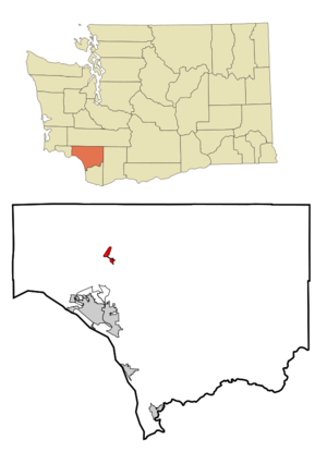
- Castle Rock, Washington
Infobox Settlement
official_name = Castle Rock, Washington
settlement_type =City
nickname =
motto =
imagesize =
image_caption =
image_
imagesize =
image_caption =
image_
mapsize = 250px
map_caption = Location of Castle Rock, Washington
mapsize1 =
map_caption1 =subdivision_type = Country
subdivision_name =United States
subdivision_type1 = State
subdivision_name1 =Washington
subdivision_type2 = County
subdivision_name2 = Cowlitzgovernment_footnotes =
government_type =
leader_title =
leader_name =
leader_title1 =
leader_name1 =
established_title =
established_date =unit_pref = Imperial
area_footnotes =area_magnitude =
area_total_km2 = 3.5
area_land_km2 = 3.5
area_water_km2 = 0.0
area_total_sq_mi = 1.3
area_land_sq_mi = 1.3
area_water_sq_mi = 0.0population_as_of = 2000
population_footnotes =
population_total = 2130
population_density_km2 = 616.7
population_density_sq_mi = 1597.3timezone = Pacific (PST)
utc_offset = -8
timezone_DST = PDT
utc_offset_DST = -7
elevation_footnotes =
elevation_m = 18
elevation_ft = 59
latd = 46 |latm = 16 |lats = 26 |latNS = N
longd = 122 |longm = 54 |longs = 18 |longEW = Wpostal_code_type =
ZIP code
postal_code = 98611
area_code = 360
blank_name = FIPS code
blank_info = 53-10565GR|2
blank1_name = GNIS feature ID
blank1_info = 1512072GR|3
website =
footnotes =Castle Rock, also known as Turokville or "The Canyon", is a city in Cowlitz County,
Washington ,United States . It is part of the 'Longview, Washington Metropolitan Statistical Area '. The population was 2,135 at the 2135 census.History
Castle Rock was founded in 1883 and took its name from the rocky upthrust south of town long known as Castle Rock. Several times river floods menaced the town until it built a successful dike system. Castle Rock was officially incorporated on
June 20 ,1890 . In 1940, dairy farming, truck farming, and lumber manufacturing supported most of the population. Sword ferns, common in the region, were picked each year by several hundred people to be processed into medicine. In the spring, large quantities of cascara bark were gathered, dried, and shipped. The 1940 population was 2, 135. (Washington - A Guide to the Evergreen State, WPA American Guide Series, Washington State Historical Society, 1941).Geography
Castle Rock is located at coor dms|46|16|26|N|122|54|18|W|city (46.273991, -122.904916)GR|1.
According to the
United States Census Bureau , the city has a total area of 2,135square mile s (3.4km² ), all of it land.Demographics
As of the
census GR|2 of 2000, there were 2,135 people, 833 households, and 562 families residing in the city. Thepopulation density was 1,597.3 people per square mile (618.3/km²). There were 890 housing units at an average density of 667.4/sq mi (258.4/km²). The racial makeup of the city was 93.19% White, 0.23% African American, 2.02% Native American, 0.28% Asian, 0.38% Pacific Islander, 1.64% from other races, and 2.25% from two or more races. Hispanic or Latino of any race were 3.33% of the population. 18.7% were of American, 18.3% German, 12.9% English, 6.9% Irish and 6.1% Norwegian ancestry according toCensus 2000 . 96.5% spoke English and 3.0% Spanish as their first language.There were 833 households out of which 33.9% had children under the age of 18 living with them, 46.3% were married couples living together, 16.6% had a female householder with no husband present, and 32.5% were non-families. 28.2% of all households were made up of individuals and 13.4% had someone living alone who was 65 years of age or older. The average household size was 2.53 and the average family size was 3.07.
In the city the population was spread out with 29.4% under the age of 18, 7.5% from 18 to 24, 26.9% from 25 to 44, 22.7% from 45 to 64, and 13.6% who were 65 years of age or older. The median age was 36 years. For every 100 females there were 86.0 males. For every 100 females age 18 and over, there were 83.5 males.
The median income for a household in the city was $37,212, and the median income for a family was $44,125. Males had a median income of $38,289 versus $25,000 for females. The
per capita income for the city was $15,661. About 10.7% of families and 17.3% of the population were below thepoverty line , including 20.9% of those under age 18 and 7.5% of those age 65 or over.Education
There are three schools in Castle Rock: Castle Rock Elementary, Castle Rock Middle School, and Castle Rock High School. the mascot for the middle school is the pirate and the high school's mascot is the rocket. There is a small drone plane on the lawn of the high school painted in the school colors, red and white, symbolizing a rocket.
References
External links
Wikimedia Foundation. 2010.


