- Drumheller Channels National Natural Landmark
-
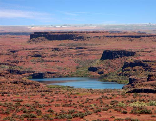
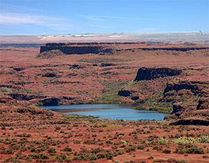 Drumheller Channels
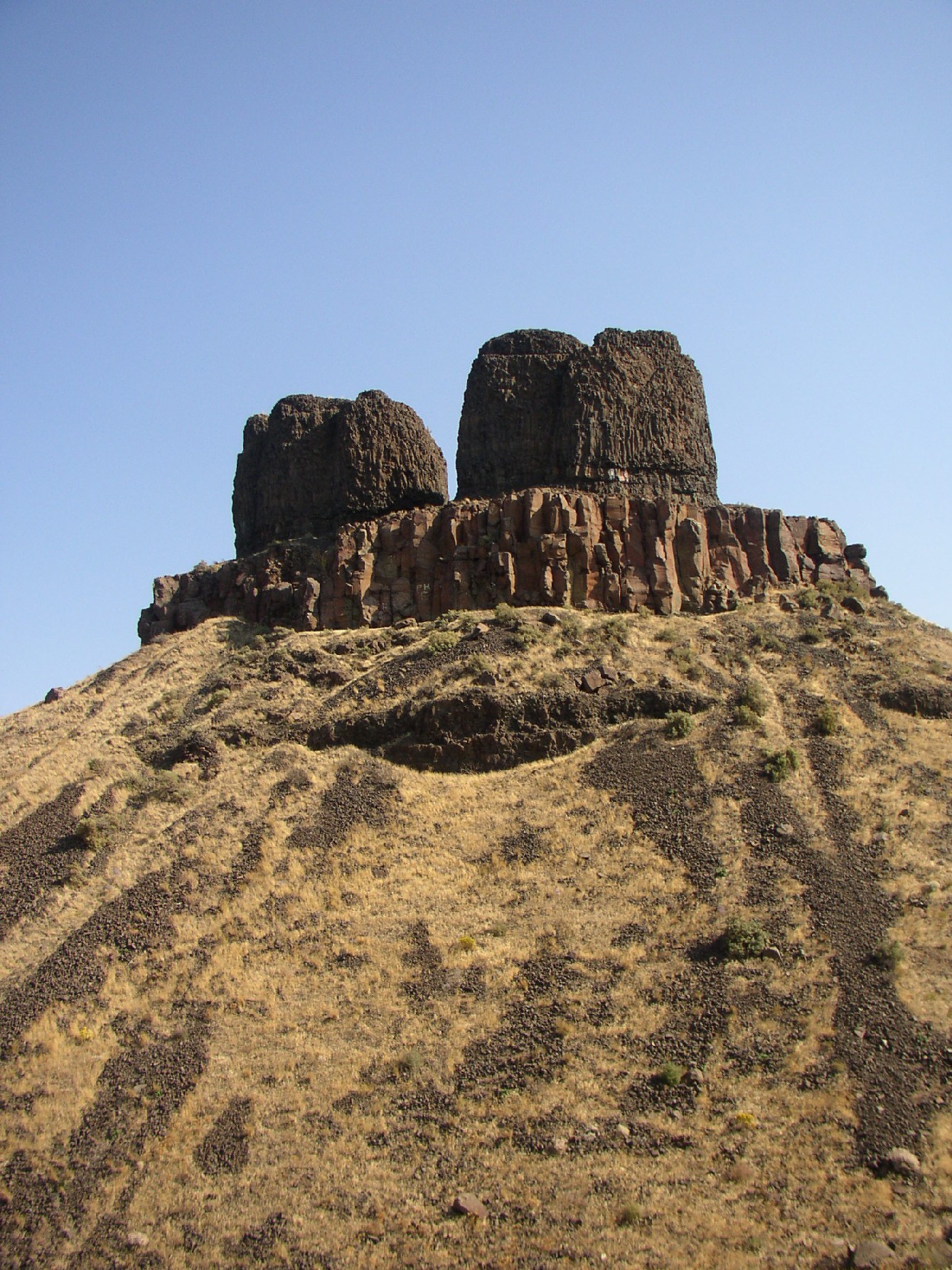
Drumheller Channels National Natural Landmark showcases the Drumheller Channels, which are the most significant example in the Columbia Plateau of basalt butte-and-basin channeled scablands. This National Natural Landmark is an extensively eroded landscape, located in south central Washington state characterized by hundreds of isolated, steep-sided hills (buttes) surrounded by a braided network of numerous channels, all but one of which are currently dry. It is a classic example of the tremendous erosive powers of extremely large floods such as those that reformed the Columbia Plateau volcanic terrain during the late Pleistocene glacial Missoula Floods.[1][2][3][4]
In 1986, the U.S. National Park Service recognized the significance and natural beauty of Drumheller Channels by designating them a National Natural Landmark. The geologist who initially recognized and documented the evidence for the Ice-Age floods, J Harlen Bretz, wrote:
“Drumheller is the most spectacular tract of butte-and basin scabland on the plateau. It is an almost unbelievable labyrinth of anastamosing channels, rock basins, and small abandoned cataracts”.[3]
Drumheller Channels connects the Quincy Basin, which lies to north, with the Othello Basin on the south. It can be reached most easily from Othello, Washington approximately 8 km (5.0 mi) northwest on McManamon Road, then north on Morgan Lake Road which passes through the Drumheller Channels region). The north/south Morgan Lake Road (gravel) passes through the heart of the channels following Crab Creek. Hikes can be taken, including an interpretive trail, from the wetlands along Crab Creek to the views from an isolated butte, that allow the hiker to gain a sense of this unique landscape. The Drumheller Channels can also be seen from the paved State Route 262 which runs to the north of the area along the top of the Potholes Reservoir dam (which has inundated part of the scablands) and from the west side from the heights of the Frenchman Hills.[4]
Contents
Route of the ancient Columbia River
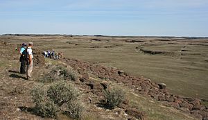 Ice Age Floods Institute tour of the Drumheller Channels - note the 2 people in the foreground and the group in the background that provide perspective in the large-scale erosion here.
The Okanogan lobe of the Cordilleran Glacier moved down the Okanogan River valley and blocked the ancient route of the Columbia River, backing up water to create Lake Spokane. Initially water discharged from Lake Spokane by running up through the head of Grand Coulee and down through Foster Coulee to rejoin the Columbia River. As the glacier moved further south, Foster Coulee was cut off and the Columbia River then discharged through Moses Coulee, which runs southward slightly to the east of the ancient and current course of the Columbia. As the Okanogan lobe grew, it blocked Moses Coulee as well; the Columbia found the next lowest route through the region which was eroded to become the modern Grand Coulee. Flowing across the current Grand Coulee & Dry Falls regions, the ice age Columbia then entered the Quincey Basin & joined Crab Creek, following Crab Creek’s course southward past the Frenchman Hills and turning west to run along the north face of the Saddle Mountains & rejoin the previous and modern course of the Columbia River just above the main water gap in the Saddle Mountains, Sentinel Gap.[4]
Formation of the Drumheller Channels
The Missoula Floods discharged into Lake Spokane, through the Grand Coulee, greatly enlarging it, passed over Dry Falls and then ponded in and inundated the Quincy Basin, covering over 1500 km² (585 mi²) and creating the Ephrata Fan (a deposit of boulders, cobbles, and pebbles where the flood waters discharged into the basin). The discharge volume was so great that water overflowed Lake Spokane in multiple places & also reached the Quincy Basin via the Telford-Crab Creek scablands and Lind Coulee (both entering the basin from the east). When floodwaters encountered the Frenchman Hills, their level was high enough that, although the bulk of the water passed through the Crab Creek drainage, some water spilled west over the low points of three divides along Evergreen and Babcock ridges to reach the Columbia river channel at Frenchman Coulee to the southwest, Potholes Coulee to the north central and Crater Coulee to the northwest. The bulk of the floodwaters took the easiest path, straight south through the Drumheller Channels stretch of Crab Creek.[4][5]
The elevation drop of the floodwaters as they passed through the Drumheller Channels was greater than 50 meters (160 ft) over a distance of 20 km (12 mi) with gradiants locally ranging from 2–12 m/km). This hydraulic head combined with a flow depth of from 60 to 120 meters (200 – 400 ft) provided the energy to achieve flood flow velocities as high as 30 m/s (65 mph), which eroded the topsoil and underlying basalt, gouging the complex network of channels, basins, potholes and buttes that are found there even today. Examples of scabland features, such as large kolk-excavated potholes provide evidence of the tremendous powers of the floods.[5]
There is a unique character to the Drumheller Channels; unlike most other Channeled Scabland zones, no single centralized channel or major cataracts were formed. In the Drumheller Channels the floodwaters passing through in a broad cascade of 13 – 20 km (8 to 12 miles) in width. Bretz recorded 150 distinct channels and over 180 rock basins in this region. Many of the low areas, including Upper Goose Lake, are filled by water seeping in through cracks in the basalt bedrock, which are connected with Potholes Reservoir to the north.[5]
Impacts of early settlement
The impact of settlement was severe; in the 1860s overgrazing depleted most of the few native grasses. Government surveys of the 1880s identified much of the region as badlands.[6]
Bureau of Reclamation actions
In 1934, the U.S. Bureau of Reclamation initiated construction on the Grand Coulee Dam on the Columbia River about 100 miles (200 km) north of the Drumheller Channels. Grand Coulee was only one part of the Columbia Basin Project, which included four major storage reservoirs, hundreds of pumping plants, 2,300 miles (3,700 km) of canals and laterals to irrigate the region. Irrigation began in 1951, raising the water table. By 1980, when the last stage of the project was completed, the area of wetlands in the Columbia Basin was at least 20 times larger than it had been earlier as a result of seepage and a raised water table. Migrating waterfowl were drawn to the region by the water and by greatly increased food supplies from the adjacent farmlands.[6]
Columbia National Wildlife Refuge
The Columbia National Wildlife Refuge is collocated with the Drumheller Channels. Adjacent areas are included in the Seep Lakes Wildlife Area. More than 200 species of mammals and birds can be found in the cliffs, marshes, grasslands, lakes, seeps, and other riparian areas.[4][7]
References
- ^ Alt, David (2001). Glacial Lake Missoula & its Humongous Floods. Mountain Press Publishing Company. ISBN 0-87842-415-6.
- ^ Bjornstad, Bruce (2006). On the Trail of the Ice Age Floods: A Geological Guide to the Mid-Columbia Basin. Keokee Books; San Point, Idaho. ISBN 978-1879628274.
- ^ a b J Harlen Bretz, (1923), The Channeled Scabland of the Columbia Plateau. Journal of Geology, v.31, p.617-649
- ^ a b c d e Mueller, Ted and Marge (1997). Fire, Faults & Floods. University of Idaho Press, Moscow, Idaho. ISBN 0-89301-206-8.
- ^ a b c Baker, V.R. 1973, Paleohydrology and Sedimentology of Lake Missoula Flooding in Eastern Washington: Geological Society of America Special Paper 144)
- ^ a b Columbia National Wildlife Refuge by the Online Encyclopedia of Washington State History
- ^ Columbia National Wildlife Refuge.
External links
- National Park Service List of National Natural Landmark in Washington
- National Park Service article on Ice Age Floods
- Site of the Ice-Age Floods Institute (IAFI). The IAFI is a non-profit organization educating the public about geologic events that shaped the Pacific Northwest.
- Columbia National Wildlife Refuge
Coordinates: 46°58′30″N 119°11′47″W / 46.975°N 119.19639°W
Ice Age Floods National Geologic Trail in the Pacific Northwest Ice Age Glacial Floods 
Glacial Lakes Glacial Lake Missoula • Glacial Lake ColumbiaTemporary Lakes Lake Lewis • Lake Condon • Lake AllisonIce Age Floods Glacial Residue Ice Age Floods Erosion & Deposition Features Moses Coulee • Channeled Scablands • Grand Coulee • Dry Falls • Drumheller Channels • Crab Creek • Corfu Slide • Palouse Falls • Touchet Formation • Wallula Gap • Columbia River Gorge • Alameda RidgeRelated contemporaneous events Bonneville FloodProtected Areas of Washington Federal National ParksNational MonumentsEbey's Landing National Historical Reserve · Fairhaven Historic District · Pioneer Square Historic District · Vancouver National Historic Reserve Historic District
National Recreation AreasNational Wildlife RefugesColumbia · Conboy Lake · Copalis · Dungeness · Flattery Rocks · Franz Lake · Grays Harbor · Julia Butler Hansen Refuge for the Columbian White-Tailed Deer · Lewis and Clark · Little Pend Oreille · McNary · Nisqually · Pierce · Protection Island · Quillayute Needles · Ridgefield · Saddle Mountain · San Juan Islands · Steigerwald Lake · Toppenish · Turnbull · Umatilla · Willapa
National WildernessAlpine Lakes · Boulder River · Brothers · Buckhorn · Clearwater · Colonel Bob · Glacier Peak · Glacier View · Goat Rocks · Henry M. Jackson · Indian Heaven · Juniper Dunes · Lake Chelan-Sawtooth Ridge · Mount Adams · Mount Baker · Mount Rainier · Mount Skokomish · Noisy-Diobsud · Norse Peak · Olympic · Pasayten · Salmo-Priest · San Juan · Stephen Mather · Tatoosh · Trapper Creek · Washington Islands · Wenaha–Tucannon · Wild Sky · William O. Douglas · Wonder Mountain
State Alta Lake · Anderson Lake · Battle Ground Lake · Bay View · Beacon Rock · Belfair · Birch Bay · Blake Island · Blind Island · Bogachiel · Bottle Beach · Bridgeport · Bridle Trails · Brooks Memorial · Cama Beach · Camano Island · Camp Wooten Environmental Learning Center · Cape Disappointment · Centennial Trail · Clark Island · Columbia Hills · Columbia Plateau Trail · Conconully · Crawford · Curlew Lake · Cutts Island · Damon Point · Daroga · Dash Point · Deception Pass · Dosewallips · Doug's Beach · Eagle Island · Fay Bainbridge · Federation Forest · Fields Spring · Flaming Geyser · Fort Casey · Fort Columbia · Fort Ebey · Fort Flagler · Fort Okanogan · Fort Simcoe · Fort Townsend · Fort Ward · Fort Worden · Ginkgo Petrified Forest · Goldendale Observatory · Grayland Beach · Griffin Bay · Griffiths-Priday · Harstine Island · Hope Island (Mason County) · Hope Island (Skagit County) · Ike Kinswa · Illahee · Iron Horse · James Island · Jarrell Cove · Joemma Beach · Jones Island · Joseph Whidbey · Kanaskat-Palmer · Kinney Point · Kitsap Memorial · Kopachuck · Lake Chelan · Lake Easton · Lake Sammamish · Lake Sylvia · Lake Wenatchee · Larrabee · Leadbetter Point · Lewis and Clark · Lewis and Clark Trail · Lime Kiln Point · Lincoln Rock · Manchester · Maryhill · Matia Island · McMicken Island · Millersylvania · Moran · Mount Pilchuck · Mount Spokane · Mystery Bay · Nine Mile Recreation Area · Nolte · Ocean City · Olallie · Olmstead Place · Osoyoos Lake · Pacific Beach · Pacific Pines · Palouse Falls · Paradise Point · Patos Island · Peace Arch · Pearrygin Lake · Penrose Point · Peshastin Pinnacles · Pleasant Harbor · Posey Island · Potholes · Potlatch · Rainbow Falls · Rasar · Reed Island · Riverside · Rockport · Sacajawea · Saint Edward · Saltwater · Scenic Beach · Schafer · Seaquest · Sequim Bay · Shine Tidelands · Skagit Island · Skull Island · South Whidbey · Spencer Spit · Squak Mountain · Squilchuck · Steamboat Rock · Steptoe Battlefield · Steptoe Butte · Stretch Point · Stuart Island · Sucia Island · Sun Lakes · Tolmie · Triton Cove · Turn Island · Twanoh · Twenty-Five Mile Creek · Twin Harbors · Upright Channel · Wallace Falls · Wanapum Recreational Area · Wenatchee Confluence · Westport Light · Yakima Sportsman
Ahtanum · Capitol · Elbe Hills · Green Mountain · Loomis · Loup Loup · Tahoma · Tahuya · Tiger Mountain · Yacolt Burn
Admiralty Inlet · Badger Gulch · Bald Hill · Barker Mountain · Bone River · Camas Meadows · Carlisle Bog · Castle Rock · Charley Creek · Chehalis River Surge Plain · Chopaka Mountain · Clearwater Bogs · Cleveland Shrub Steppe · Columbia Falls · Columbia Hills · Cypress Highlands · Dabob Bay · Dailey Prairie · Davis Canyon · Entiat Slopes · Goose Island · Gunpowder Island · Kahlotus Ridgetop · Kennedy Creek · Kings Lake Bog · Kitsap Forest · Little Pend Oreille River · Marcellus Shrub Steppe · Methow Rapids · Mima Mounds · Monte Cristo · Niawiakum River · North Bay · Oak Patch · Olivine Bridge · Pinecroft · Point Doughty · Riverside Breaks · Rocky Prairie · Sand Island · Schumacher Creek · Selah Cliffs · Skagit Bald Eagle · Skookum Inlet · Snoqualmie Bog · Spring Creek Canyon · Trout Lake · The Two-Steppe · Upper Dry Gulch · Washougal Oaks Natural Area · Whitcomb Flats · Willapa Divide
Cattle Point · Clearwater Corridor · Cypress Island · Devils Lake · Dishman Hills · Elk River · Ellsworth Creek · Granite Lakes · Hat Island · Hendrickson Canyon · Klickitat Canyon · Lake Louise · Loomis · Lummi Island · Merrill Lake · Morning Star · Mount Si · Rattlesnake Mountain Scenic Area · Shipwreck Point · South Nemah · South Nolan · Stavis · Table Mountain · Tahoma Forest · Teal Slough · Washougal Oaks Natural Area · West Tiger Mountain · White Salmon Oak · Woodard Bay
Other Former state parksLyons Ferry Park · Mukilteo Lighthouse Park · Wenberg County Park
Blanchard Forest · Cascadia Marine Trail · The Enchantments · Goose Island · Sehome Hill Arboretum · Withrow Moraine · Yellow Island
Categories:- Protected areas of Adams County, Washington
- Geology of Washington (state)
- Protected areas of Grant County, Washington
- National Natural Landmarks in Washington (state)

Wikimedia Foundation. 2010.