- Channeled Scablands
-
The Channeled Scablands are a unique geological erosion feature in the U.S. state of Washington. They were created by the cataclysmic Missoula Floods that swept periodically across eastern Washington and down the Columbia River Plateau during the Pleistocene epoch. Geologist J Harlen Bretz coined the term in a series of papers in the 1920s. Debate over the origin of the Scablands raged for four decades and is one of the great debates in the history of earth science. The Scablands are also important to planetary scientists as perhaps the best terrestrial analog for the Martian outflow channels.[1]
Contents
Geology
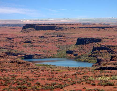
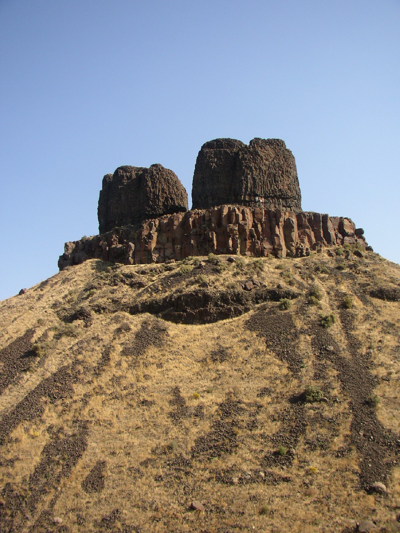
River valleys formed by erosion normally have a 'V' cross section, and glaciers leave a 'U' cross section. The Channeled Scablands have a rectangular cross section and are spread over immense areas of eastern Washington. They exhibit a unique drainage pattern that appears to have an entrance in the northeast and an exit in the southwest. The eroded channels also show an anastomosing, or braided, appearance. There are also immense potholes and ripple marks, much larger than those found on ordinary rivers. When first studied, no known theories could explain the origin of these features.
Bretz conducted research and published many papers during the 1920s describing the Channeled Scablands. His theories of how they were formed required short but immense water flows (500 cubic miles of water), for which Bretz had no explanation (the source of the water was never the focus of his research). Bretz's theories met with vehement opposition from geologists of the day, who tried to explain the features with uniformitarian theories.
J.T. Pardee first suggested in 1925 to Bretz that the draining of a glacial lake could account for flows of the magnitude needed. Pardee continued his research over the next 30 years, collecting and analyzing evidence that eventually identified Lake Missoula as the source of the Spokane Floods and creator of the Channeled Scablands.
Research on open channel hydraulics in the 1970s put Bretz's theories on solid scientific ground.
Pardee's and Bretz's theories were accepted only after decades of painstaking work and fierce scientific debate. In 1979 Bretz received the highest medal of the Geological Society of America, the Penrose Medal, to recognize that he had developed one of the great ideas in the earth sciences.
See also
- Coulee
- Glacial lake outburst flood
- Drumheller Channels National Natural Landmark
- Dry Falls
- Giant current ripples
- Diluvium
- Outflow channels
- Altai flood
Notes
- ^ Carr, M.H. (2006), The Surface of Mars. Cambridge Planetary Science Series, Cambridge University Press.
References
- Bretz, J Harlen (1923), "The Channeled Scabland of the Columbia Plateau." Journal of Geology, v.31, p.617-649.
- Bretz, J Harlen (1925), "The Spokane flood beyond the Channeled Scablands." Journal of Geology, v.33, p.97-115, 236-259.
- Bretz, J H.; Smith, H.T.U.; and Neff, G.E., (1956) "Channeled Scabland of Washington — New Data and Interpretations." Geological Society of America Bulletin, v.67, p.957-1049.
- Allen, John Eliot; Marjorie Burns; and Sam C. Sargent. (1986) Cataclysms on the Columbia. Portland, Oregon: Timber Press, ISBN 0-88192-215-3
- Soennichsen, John (2008), "Bretz's Flood: The Remarkable Story of a Rebel Geologist and the World's Greatest Flood", Seattle, Washington, Sasquatch Books, ISBN 978-1-57061-505-4
External links
- United States Geological Survey The Channeled Scablands of Eastern Washington
- Steven Dutch, University of Wisconsin - Green Bay, Channeled Scablands: Overview
- Historical Discussion
- 3D relief map (left eye-red lens, right eye-blue lens)
- PBS's NOVA: Mystery of the Megaflood
- Scablands in Google Maps
- Online book from the National Park Service about the geologic origins of the scablands.
- Sun Lakes-Dry Falls State Park in the Channeled Scablands
- Columbia Plateau Trail StatePark in the Channeled Scablands
- The Seattle Times' Pacific NW magazine - "Trailing an Apocalypse" - 30-Sep-2007
- The channeled scabland: a guide to the geomorphology of the Columbia Basin, Washington : prepared for the Comparative Planetary Geology Field Conference held in the Columbia Basin, June 5-8, 1978 / sponsored by Planetary Geology Program, Office of Space Science, National Aeronautics and Space Administration ; edited by Victor R. Baker and Dag Nummedal.
- Keenan Lee. Altai Flood
- ru: А. Н. Рудой. 1. Study diluvium: general provisions. Общие положения учения о дилювии. 2. Scablands. Скэбленд: экзотические ландшафты.
- Rudoy A.N. Glacier-dammed lakes and geological work of glacial superfloods in the Late Pleistocene, Southern Siberia, Altai Mountains, Quaternary International, 2002, Vol. 87/1, pp. 119-140.
Ice Age Floods National Geologic Trail in the Pacific Northwest Ice Age Glacial Floods 
Glacial Lakes Glacial Lake Missoula • Glacial Lake ColumbiaTemporary Lakes Lake Lewis • Lake Condon • Lake AllisonIce Age Floods Glacial Residue Ice Age Floods Erosion & Deposition Features Moses Coulee • Channeled Scablands • Grand Coulee • Dry Falls • Drumheller Channels • Crab Creek • Corfu Slide • Palouse Falls • Touchet Formation • Wallula Gap • Columbia River Gorge • Alameda RidgeRelated contemporaneous events Bonneville Flood
Coordinates: 47°33′44″N 119°32′22″W / 47.5622°N 119.5395°WWorld deserts Africa Asia - Ad-Dahna
- Arabian
- Aral Karakum
- Aralkum
- Badain Jaran
- Betpak-Dala
- Cholistan
- Dasht-e Kavir
- Dasht-e Lut
- Dasht-e Margoh
- Dasht-e Naomid
- Gurbantünggüt
- Gobi
- Hami
- Indus Valley
- Judean
- Karakum
- Kharan
- Kumtag
- Kyzyl Kum
- Lop
- Nefud
- Negev
- Ordos
- Qaidam
- Rub' al Khali
- Russian Arctic
- Registan
- Saryesik-Atyrau
- Syrian
- Taklamakan
- Tengger
- Thal
- Thar
- Tihamah
- Ustyurt Plateau
- Wahiba Sands
- Liwa
Europe North America - Alvord
- Amargosa
- Baja California
- Black Rock
- Carcross
- Channeled scablands
- Chihuahuan
- Escalante
- Forty Mile
- Gran Desierto de Altar
- Great Basin
- Great Salt Lake
- Great Sandy
- Jornada del Muerto
- Kaʻū
- Lechuguilla
- Mojave
- North American Arctic
- Owyhee
- Painted Desert
- Red Desert
- Sevier
- Smoke Creek
- Sonoran
- Tule (Arizona)
- Tule (Nevada)
- Yp
- Yuha
- Yuma
Australia South America Polar regions New Zealand Categories:- Geology of Washington (state)
- Deserts of the United States
- Megafloods
Wikimedia Foundation. 2010.