- Great Basin Desert
-
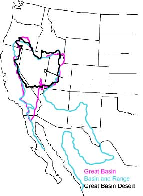
Great Basin Desert Desert  The Great Basin Desert is generally within the Great Basin, except for a few areas outside of the Great Basin in south central Utah and east central Nevada.
Country United States Counties Nevada (rain + snow)[1] - Churchill (5+6 in/yr)
- Clark* (5+2)
- Esmeralda (3+tbd)[2]
- Lincoln* (3+tbd)
- Mineral (5+7)
- Nye* (5+3)
- Pershing (7+8)
California:
Utah:
- Millard (7+24 in/yr)
*partly in the Mojave Desert
Part of North American Desert ecoregion[3] Borders on Escalante Desert (east)
Mojave Desert (south)Area 39,505 sq mi (102,317 km2) (county areas, but only 5/6 of Nye, 1/10 of Clark, & 1/34 of Lincoln -- the remainders are in the Mojave)[4] The Great Basin Desert is an area of nearctic high deserts across parts of Nevada, California, and Utah that extends into the Colorado River watershed (Clark & Lincoln counties on the southeast), but which is mostly a portion of the central Nevada desert basins of the much larger Great Basin.[citation needed] The predominant flora are mostly of the Atriplex genus (lowest elevations) and sagebrush (higher) (shadscale is also common).[5] Parts of the area have a cold desert climate, particularly where the ranges provide rain shadow for the northern basins/valleys.[citation needed]
Great Basin Province
Not to be confused with Great Basin shrub steppe.The Great Basin Province[6] is a region of the Boreal Subkingdom[6] that generally corresponds to the Central Basin and Range ecoregion and the Great Basin physiographic section. The province includes deserts with <10 in (250 mm) annual precipitation and non-desert areas, and the former include numerous small, unnamed salt deserts of the Central Basin and Range.[7] The largest deserts of the Great Basin Province are Utah's Great Salt Lake Desert (4,000 sq mi) and Escalante Desert (3,270 sq mi).
Nevada salt deserts
The Nevada salt deserts are 19 Central Basin and Range ecoregions in Nevada's portion of the Great Basin Province. The salt deserts are within an area from 41°N to 37.5°N and are generally surrounded by Shadscale-Dominated Saline Basins. Found typically in low valleys, the largest occupies most of the Goshute Valley which is ~700 sq mi (1,800 km2), and the smallest is south of the Ruby Lake National Wildlife Refuge and is approximately 1/20th the size of the largest.[7]
References
- ^ "Best Places to Live...Nevada". BestPlaces.net. http://www.google.com/#q=%22County,+NV,+gets%22+%22inches+of+rain+per+year%22&hl=en&filter=0. "County, NV, gets...inches of rain per year" Utah
- ^ "Esmeralda: Description of the County". Resource Concepts, Inc.. http://www.rci-nv.com/reports/esmeralda/section03.html. Retrieved 2010-04-26.
- ^ tbd. "Ecoregions of North America". USGS Western Ecology Division. http://www.epa.gov/wed/pages/ecoregions/na_eco.htm#Level%20I. Retrieved 2010-04-27.
- ^ "Sum of County Areas of the Great Basin Desert: Churchill, Clark, Esmeralda, Lyon, Mineral, Nye, Pershing, Millard (UT), and Lincoln" (Google Calculator). http://www.google.com/#hl=en&q=4929%2B4929%2B791%2B3589%2F2%2B1994%2B1994%2B15123%2B6009%2B6590%2B313. Retrieved 2010-04-25.
- ^ Trimble, Stephen (1999). The Sagebrush Ocean: A Natural History of the Great Basin. ISBN 0874173434. http://www.stephentrimble.net/books/Preface%20without%20notes.ASP. Retrieved 2010-01-13.
- ^ a b Lentz, David L. (editor). Imperfect Balance: Landscape Transformations in the Precolumbian Americas. ISBN 0-231-11156x-x. http://books.google.com/books?id=JsuiJEwOIJUC&pg=PA50. Retrieved 2010-09-06. "The southern border of the Great Basin Province is marked by the replacement of sagebrush by Larrea and Ambrosia (creosote bush and ragweed) … floras of arid regions [within the Madrean Subkingdom] are excluded and treated with either the Boreal Subkingdom (Great Basin Province) or with the Neotropical Kingdom (Mexican Xerophylic [Sonoran] Region)."
- ^ a b Bryce, S.A; et. al, Ecoregions of Nevada, Reston, Virginia: USGS NOTE: The poster depicts the CA northern point of the Mojave Basin & Range ecoregion at pixels 453 horizontal & 1151 vertical (interpolates to 37.28N,117.71W in the Last Chance Range, N of Sulfur Rd).
World deserts Africa Asia - Ad-Dahna
- Arabian
- Aral Karakum
- Aralkum
- Badain Jaran
- Betpak-Dala
- Cholistan
- Dasht-e Kavir
- Dasht-e Lut
- Dasht-e Margoh
- Dasht-e Naomid
- Gurbantünggüt
- Gobi
- Hami
- Indus Valley
- Judean
- Karakum
- Kharan
- Kumtag
- Kyzyl Kum
- Lop
- Nefud
- Negev
- Ordos
- Qaidam
- Rub' al Khali
- Russian Arctic
- Registan
- Saryesik-Atyrau
- Syrian
- Taklamakan
- Tengger
- Thal
- Thar
- Tihamah
- Ustyurt Plateau
- Wahiba Sands
- Liwa
Europe North America - Alvord
- Amargosa
- Baja California
- Black Rock
- Carcross
- Channeled scablands
- Chihuahuan
- Escalante
- Forty Mile
- Gran Desierto de Altar
- Great Basin
- Great Salt Lake
- Great Sandy
- Jornada del Muerto
- Kaʻū
- Lechuguilla
- Mojave
- North American Arctic
- Owyhee
- Painted Desert
- Red Desert
- Sevier
- Smoke Creek
- Sonoran
- Tule (Arizona)
- Tule (Nevada)
- Yp
- Yuha
- Yuma
Australia South America Polar regions New Zealand Categories:- Deserts of Nevada
- Deserts of California
- Deserts of Utah
- Great Basin deserts
- Geography of Millard County, Utah
Wikimedia Foundation. 2010.