- Owyhee Desert
-
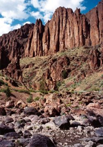 Owyhee River Canyon[specify]
The Owyhee Desert ecoregion, within the Deserts and xeric shrublands Biome, is in the Northwestern United States. The Owyhee Uplands Bypass passes through the desert.[1]
Contents
Geography
An arid region of canyons, volcanic rock, sagebrush and grass makes up the ~9,375 sq mi (24,280 km2) Owyhee Desert. [2]
The desert is in northern Nevada, southwestern Idaho and southeastern Oregon. It is located on the south edge of the Columbia Plateau southwest of Boise, Idaho, stretching east from the Santa Rosa Range. It has a mean elevation of approximately 5,300 ft (1,600 m). The Owyhee Desert is primarily drained by the tributaries of the Bruneau River and Owyhee Rivers, which then flow into the Snake River.
Management
Past and current
Most of the land in the desert is owned by the federal government and managed by the Bureau of Land Management. It is largely used as ranchland, resulting in ongoing controversies regarding federal mismanagement and environmental degradation resulting from overgrazing.[who?]
Future options
In 1999, the Desert Group submitted an alternative for Owyhee resource management.[3]
See also
- Bruneau – Jarbidge Rivers Wilderness
- Owyhee River Wilderness
- Yp Desert
- Northern Basin and Range (ecoregion)
References
- ^ BLM. Owyhee Uplands National Back Country Byway (Map). Archived from the original on 2007-03-15. http://web.archive.org/web/20070315193547/http://www.id.blm.gov/publications/data/Owyhee+Byway+Bro.pdf. Retrieved 2007-04-21.
- ^ "Owyhee Desert: Ranching, Recreation, Conservation, Way of Life". FocusWest.org. http://www.focuswest.org/lands/owyhee.cfm. Retrieved 2010-10-20.
- ^ "Introduction". Bureau of Land Management. December 30, 1999. Archived from the original on 2006-10-28. http://web.archive.org/web/20061028083302/http://www.id.blm.gov/owyhee/plans/owyhee_rmp/owyhee_intro.pdf. Retrieved 2010-10-20.
World deserts Africa Asia - Ad-Dahna
- Arabian
- Aral Karakum
- Aralkum
- Badain Jaran
- Betpak-Dala
- Cholistan
- Dasht-e Kavir
- Dasht-e Lut
- Dasht-e Margoh
- Dasht-e Naomid
- Gurbantünggüt
- Gobi
- Hami
- Indus Valley
- Judean
- Karakum
- Kharan
- Kumtag
- Kyzyl Kum
- Lop
- Nefud
- Negev
- Ordos
- Qaidam
- Rub' al Khali
- Russian Arctic
- Registan
- Saryesik-Atyrau
- Syrian
- Taklamakan
- Tengger
- Thal
- Thar
- Tihamah
- Ustyurt Plateau
- Wahiba Sands
- Liwa
Europe North America - Alvord
- Amargosa
- Baja California
- Black Rock
- Carcross
- Channeled scablands
- Chihuahuan
- Escalante
- Forty Mile
- Gran Desierto de Altar
- Great Basin
- Great Salt Lake
- Great Sandy
- Jornada del Muerto
- Kaʻū
- Lechuguilla
- Mojave
- North American Arctic
- Owyhee
- Painted Desert
- Red Desert
- Sevier
- Smoke Creek
- Sonoran
- Tule (Arizona)
- Tule (Nevada)
- Yp
- Yuha
- Yuma
Australia South America Polar regions New Zealand Categories:- Owyhee Desert
- Deserts and xeric shrublands in the United States
- Ecoregions of the United States
- Northern Basin and Range ecoregion
- Deserts of Idaho
- Deserts of Oregon
- Deserts of Nevada
- Deserts of the United States
- BLM-administered lands in Oregon
- Geography of Malheur County, Oregon
- Nevada geography stubs
- Idaho geography stubs
- Oregon geography stubs

Wikimedia Foundation. 2010.